
Arizona Eagle Mining Corp. Completes Acquisition of Three Past-Producing High-Grade Silver Mines to Consolidate Eagle Silver Project
Arizona Eagle Mining (TSXV: AZEM, OTCQB: AZEMF) has completed the acquisition of 62 acres of patented land hosting three past‑producing high‑grade silver mines – Arizona National, Lookout and Silver Belt – known as the Silver Parcels.
Sentiment and the balance of points
Rhea-AI Sentiment reads the wording of the document, how positive or negative its language is on a 1 to 5 scale. The balance of points shown with the takes weighs what the document actually discloses, so the two can disagree, for example when a trial that missed its main goal is described in upbeat language.
Rhea-AI Summary
Arizona Eagle Mining (TSXV: AZEM, OTCQB: AZEMF) has completed the acquisition of 62 acres of patented land hosting three past‑producing high‑grade silver mines – Arizona National, Lookout and Silver Belt – known as the Silver Parcels. The ground lies on strike and about one kilometre northeast of the McCabe gold‑silver deposit and includes an operating water well with extraction rights.
According to Arizona Eagle, the acquisition consolidates the Eagle Silver Project, extends the mineralized structural corridor northeast of McCabe by 50% (from 3 km to 4.5 km), and increases patented land ownership by 18% (from 348 to 410 acres). Surface and waste‑pile sampling on the Eagle Silver area has returned notable grades, including up to 861 g/t silver and 15.6 g/t gold, plus zinc and lead values from Arizona National Mine tailings. The company holds a 100% interest in the broader Eagle Project in Yavapai County, now totaling over 4,000 acres, and has completed a seven‑hole Phase 1 drill program at McCabe, with assays from five holes pending.
Positive
- Completed acquisition of 62 acres with three past‑producing silver mines on patented land
- Mineralized corridor northeast of McCabe extended by 50%, from 3 km to 4.5 km
- Patented land position expanded by 18%, from 348 to 410 acres
- Waste‑pile sampling returned up to 861 g/t silver and 15.6 g/t gold
- Arizona Eagle now controls over 4,169–4,231 acres at the Eagle Project area
- Historic McCabe estimate reported 878,000 oz gold @ 11.7 g/t and 5M oz silver @ 69 g/t
Negative
- None.
News Explained
The acquisition is complete, but the release gives no consideration or dilution terms, so its immediate cash and ownership effect on existing common holders cannot be assessed from this disclosure.
Details
News Market Reaction – AZEMF
On Aug 17, the day this news came out, AZEMF closed 9.84% above the previous close.
Data tracked by StockTitan Argus for the Aug 17 session.
AI-generated analysis. How Rhea-AI works. Not financial advice.




Toronto, Ontario--(Newsfile Corp. - August 17, 2026) - Arizona Eagle Mining Corp. (TSXV: AZEM) (OTCQB: AZEMF) (the "Company" or "Arizona Eagle") is pleased to announce that it has completed the acquisition of 62 acres of patented land that host three past-producing high-grade silver mines: the Arizona National Mine, the Lookout Mine and the Silver Belt Mine (the "Silver Parcels"). These five parcels are located on strike with, and approximately one kilometre northeast of, the Company's McCabe gold-silver deposit. The acquisition included an operating water well with extraction rights.
Kevin Reid, Chief Executive Officer of Arizona Eagle, commented:
"We are pleased to close the strategic acquisition of three past-producing high-grade silver mines, consolidating the Eagle Silver Project, located within close proximity of the gold and silver McCabe Mine. These high-grade silver mines served as major sources of silver production in Arizona until the 1930s. Mining operations at that time were limited to relatively shallow oxidized depths, with the deepest shaft reaching only 150 metres, allowing for the opportunity for further discoveries at depth. These mines have been privately held by multiple parties and dormant for almost 100 years. Surface sampling on the Eagle Silver property has returned grades up to 344 g/t silver, with sampling of the Arizona National Mine waste pile returning grades of up to 861 g/t silver and 15.6 g/t gold. An additional sampling program was recently completed on the newly acquired claims.
Applying the same strategy we are employing at the McCabe gold-silver deposit, we see the opportunity to revive these mines through the application of modern exploration methods and systematic drilling, and we firmly believe that the Eagle Project offers exceptional discovery potential in one of Arizona's most prolific historic gold-silver districts. These acquisitions extend the structural corridor of mineralization northeast of McCabe by
Previously reported surface sampling on these claims by Arizona Eagle has returned silver grades including 344 g/t, 255 g/t, 234 g/t, as well as 2.4 g/t gold. Recent testing of the tailings dumps in the first quarter of 2026 adjacent to the Arizona National Mine shaft included a sample that returned a grade of 861 g/t silver,
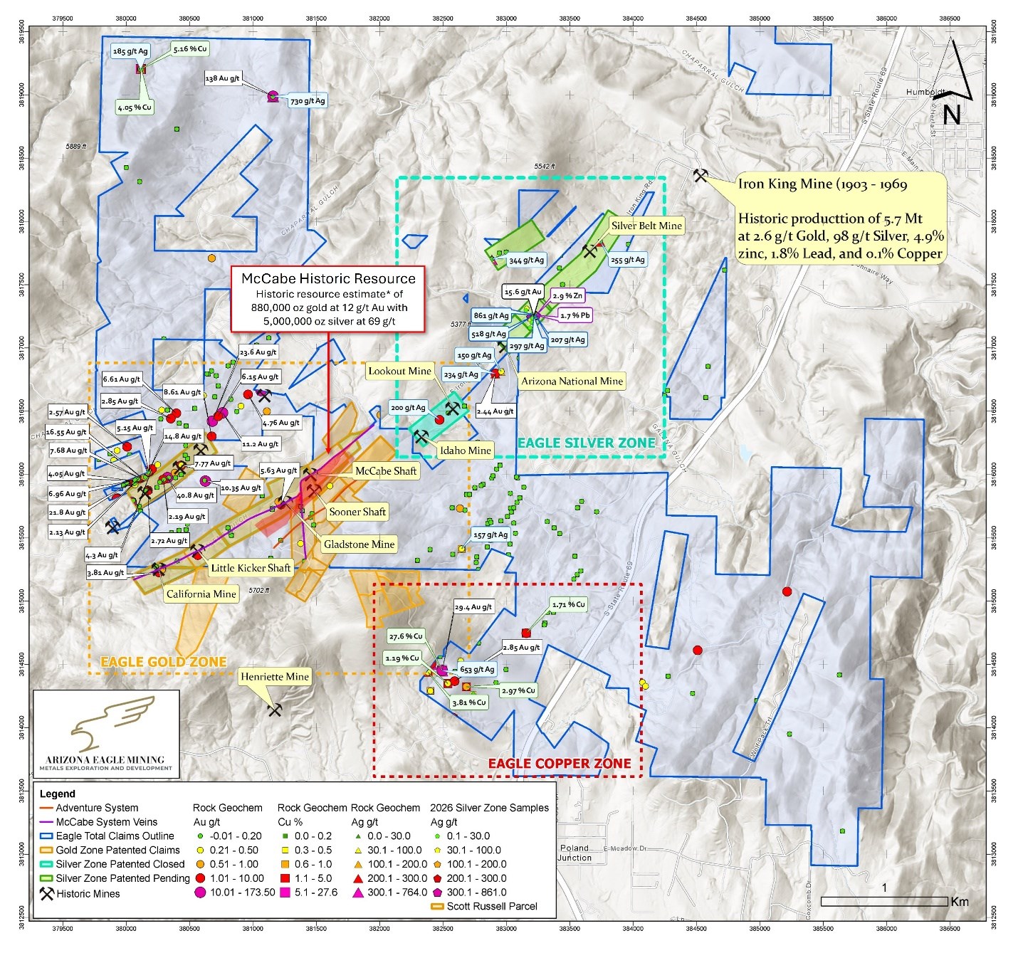
Figure 1. Eagle Silver Zone displaying Arizona National, Lookout, and Silver Belt Mines
To view an enhanced version of this graphic, please visit:
https://images.newsfilecorp.com/files/10145/309755_a5aa0477d45dc930_002full.jpg
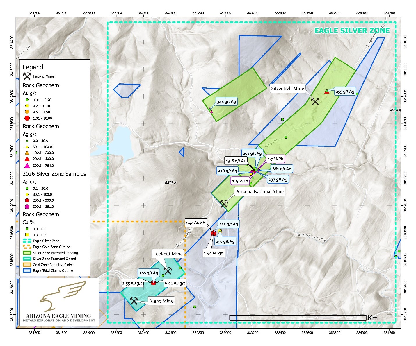
Figure 2. Select surface sampling results completed by Arizona Eagle on Eagle Silver Project
To view an enhanced version of this graphic, please visit:
https://images.newsfilecorp.com/files/10145/309755_a5aa0477d45dc930_003full.jpg
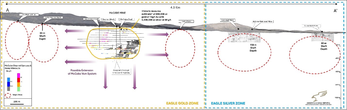
Figure 3. Long section showing drill targets at Eagle Gold Zone (3km of strike), with Eagle Silver Zone extending to NE (1.5 km of strike)
To view an enhanced version of this graphic, please visit:
https://images.newsfilecorp.com/files/10145/309755_a5aa0477d45dc930_004full.jpg
Arizona National Mine
The Arizona National Mine is comprised of three shafts and seven levels to a depth of 500 feet (150 metres). The deposit was mined intermittently between 1915 and 1931 and reported shipments of silver-lead ore and concentrates (Anderson, 19581).
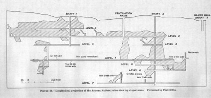
Figure 4. Long section of the Arizona National Mine showing 7 levels to 500 feet deep
To view an enhanced version of this graphic, please visit:
https://images.newsfilecorp.com/files/10145/309755_a5aa0477d45dc930_005full.jpg
Sampling conducted in February 2026 of the Arizona National Mine waste pile undertaken by the Company returned numerous samples of high-grade silver, gold and zinc (see Table 1 below). An additional sampling program was completed on the parcels in July 2026, with results pending.
| Sample | Silver (g/t) | Gold (g/t) | Lead (%) | Zinc (%) |
| SS01 | 0.05 | <0.005 | 0.00054 | 0.0015 |
| SS02 | 207 | 0.138 | 0.133 | 0.326 |
| SS03 | 861 | 0.156 | 1.67 | 2.88 |
| SS04 | 2.71 | 0.017 | 0.0143 | 0.0237 |
| SS05 | 518 | 0.052 | 0.65 | 1.26 |
| SS06 | 3.14 | 0.005 | 0.00401 | 0.0083 |
| SS07 | 5.97 | 0.008 | 0.0081 | 0.0099 |
| SS08 | 32.3 | 0.036 | 0.359 | 1.07 |
| SS09 | 297 | 15.55 | 1.48 | 0.337 |
| SS10 | 11.4 | 0.03 | 0.0222 | 0.0309 |
| SS11 | 1.17 | 0.018 | 0.00502 | 0.0114 |
| SS12 | 26.7 | 0.006 | 0.01265 | 1.955 |
| SS13 | 0.44 | <0.005 | 0.0012 | 0.006 |
| SS14 | 0.35 | <0.005 | 0.0011 | 0.012 |
| SS15 | 51.4 | 0.067 | 0.132 | 0.565 |
| SS16 | 0.19 | <0.005 | 0.00074 | 0.0058 |
| SS17 | 67.3 | 0.018 | 0.125 | 0.303 |
Table 1: Arizona National Mine Waste Pile Sample Results
Lookout Mine
This Lookout Mine is located on the Silver Belt vein, about 1,000 feet (304 metres) southwest of the Arizona National Mine. The mine was last in operation from 1948-1949 and production was reported to consist chiefly of galena (lead sulphide), sphalerite (zinc sulphide) and gold (Anderson, 19581).
Silver Belt Mine
The Silver Belt Mine was discovered in the 1880s and was mined until the 1930s. The mine includes four shafts and at least four underground levels. This deposit was mined to a depth of only 250 feet (80 metres), with grades reported up to 20 ounces per ton silver (600 g/t), with
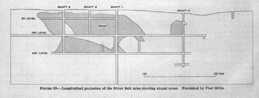
Figure 5. Long section of Silver Belt Mine, which ended production in 1949.
To view an enhanced version of this graphic, please visit:
https://images.newsfilecorp.com/files/10145/309755_a5aa0477d45dc930_006full.jpg
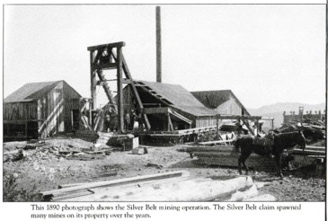
Figure 6. 1890 photograph of the Silver Belt Mine which operated until the 1930s.
To view an enhanced version of this graphic, please visit:
https://images.newsfilecorp.com/files/10145/309755_a5aa0477d45dc930_007full.jpg
Eagle Project Overview
Arizona Eagle holds a
Over the past two years, Arizona Eagle has expanded its total land position to 4,231 acres through staking and acquisitions surrounding the McCabe Mine. During this time, the Company completed exploration programs focused on geological mapping, surface sampling, helicopter-borne VTEM surveys and ground-based induced polarization surveys that identified multiple parallel mineralized structures that have not been historically drill tested.
Phase 1 Drill Program
In the first quarter of 2026, the Company initiated Phase 1 drill program of 7 holes. The drill program was designed in part to explore the lateral and vertical continuity of the McCabe veins in and around the historic resource. Results of the first 2 holes were announced on May 6th, 2026, with the remaining 5 holes to be released in the third quarter of 2026.
Phase 2 Drill Program
The Company recently completed a sampling program on the newly acquired Silver Parcels, with results pending. A SkyTem geophysical survey is also planned to test for structural continuity between the McCabe Mine and the three past-producing silver mines, on strike to the northeast. Results of the sampling and geophysics will be used to define expansion targets on strike, as well as guide resource definition drilling at the McCabe Mine.
About Arizona Eagle Mining Corp.
Arizona Eagle is a mineral exploration company focused on the acquisition, exploration, and development of mineral properties. Arizona Eagle's principal asset is the Eagle Project, a 4,169-acre property comprised of patented and unpatented claims located near the town of Prescott Valley in Yavapai County, Arizona. The Eagle Project is centred on the past-producing McCabe Mine, a high-grade gold-silver deposit, and includes multiple parallel structures hosting past-producing mines that remain largely untested by modern drilling. While Arizona Eagle's primary focus will be on the exploration and development of the Eagle Project, it will continue to own Core Nickel's land portfolio in the Thompson Nickel Belt of northern Manitoba.
The scientific and technical information contained in this news release has been reviewed and approved by Clyde Smith, PhD, Vice-President, Exploration of the Company, who is a Qualified Person as defined under National Instrument 43-101 - Standards of Disclosure for Mineral Projects.
For Further Information
For further information on Arizona Eagle, please contact:
Kevin Reid
Chief Executive Officer and Director
Email: kreid@arizonaeaglemining.com
https://www.arizonaeaglemining.com/
Cautionary Statement Regarding Forward-Looking Statements
This news release contains forward-looking statements and forward-looking information (collectively, "forward-looking statements") within the meaning of applicable securities laws. Any statements that are contained in this news release that are not statements of historical fact may be deemed to be forward-looking statements. Forward-looking statements are often identified by terms such as "may", "should", "anticipate", "will", "estimates", "believes", "intends", "expects" and similar expressions which are intended to identify forward-looking statements. More particularly and without limitation, this news release contains forward-looking statements, including statements concerning the proposed acquisition of the Silver Parcels and the expected closing thereof, the consolidation of the Eagle Silver Project, the Company's exploration activities and drill program at the Eagle Project, the expected timing and receipt of assay results, the mobilization of additional drill rigs, and the potential expansion of the historic estimate. Forward-looking statements are inherently uncertain, and the actual performance may be affected by a number of material factors, assumptions and expectations, many of which are beyond the control of the Company, including expectations and assumptions concerning the Company's ability to complete the acquisition of the Silver Parcels on the proposed terms or at all, including the completion of satisfactory due diligence, the timely receipt of all required regulatory approvals, including the approval of the TSXV, the Company's ability to obtain clear title to the Silver Parcels, the ability of the Company to execute on the proposed exploration program at the Eagle Project, commodity price fluctuations, the availability of financing on acceptable terms, environmental and permitting risks, and risks inherent in mineral exploration and development. Readers are cautioned that assumptions used in the preparation of any forward-looking statements may prove to be incorrect. Events or circumstances may cause actual results to differ materially from those predicted as a result of numerous known and unknown risks, uncertainties and other factors, many of which are beyond the control of the Company. Readers are further cautioned not to place undue reliance on any forward-looking statements, as such information, although considered reasonable by management of the Company at the time of preparation, may prove to be incorrect and actual results may differ materially from those anticipated. The forward-looking statements contained in this news release are made as of the date of this news release and are expressly qualified by the foregoing cautionary statement. Except as expressly required by securities law, the Company does not undertake any obligation to update publicly or to revise any of the included forward-looking statements, whether as a result of new information, future events or otherwise.
1 Anderson, C.A. and Creasey, S.C. 1958. Geology and Ore Deposits of the Jerome Area, Yavapai County, Arizona. Arizona Geological Survey Professional Paper 308. United States Department of the Interior
2 The historical estimate for the McCabe Deposit is unclassified and predates, and is non-compliant with, current NI 43-101 standards; it is based on a 1984 "Total Reserve Estimate" by Stan West Mining. The Company's Qualified Person has not done significant work to classify the historic estimate as current mineral resources or current mineral reserves. Significant data compilation, re-drilling, re-sampling and data verification may be required by a Qualified Person before the historic resource can be verified and upgraded to be compliant with current NI 43-101 standards.
To view the source version of this press release, please visit https://www.newsfilecorp.com/release/309755
FAQ
AI-generated questions and answers. How Rhea-AI works. Not financial advice.