
Canadian Gold Resources Increases Québec Gaspé Land Position by 72% Through Strategic Staking Along the Garin River Fault
Canadian Gold Resources significantly expands its Gaspé Peninsula land package, targeting the Garin River Fault and new geophysical features for future exploration.
Sentiment and the balance of points
Rhea-AI Sentiment reads the wording of the document, how positive or negative its language is on a 1 to 5 scale. The balance of points shown with the takes weighs what the document actually discloses, so the two can disagree, for example when a trial that missed its main goal is described in upbeat language.
Rhea-AI Summary
Canadian Gold Resources (CDNGF) has increased its Québec Gaspé Peninsula land position by approximately 72% through staking 195 new mineral claims covering about 11,164 hectares immediately south of its Lac Arsenault and Robidoux properties.
The total land package now spans roughly 29,225 hectares (about 72,000 acres), securing additional ground along the Garin River Fault and related structural splays, which the company views as prospective for vein-type gold mineralization. Regional geophysical data also highlight a broad magnetic feature within the newly acquired area that the company considers an additional exploration target. Initial work will focus on data review and field reconnaissance to prioritize follow-up exploration.
Positive
- Land position +72% to approximately 29,225 hectares across Québec's Gaspé Peninsula
- 195 new mineral claims covering about 11,164 hectares staked south of Lac Arsenault and Robidoux
- Expanded exposure along the Garin River Fault and related structural splays viewed as prospective for vein-type gold
- New geophysical target identified via a broad magnetic feature within the newly staked area
- 58,068,876 common shares outstanding post-closing of the Placement, clarifying current share capital
Negative
- None.
AI-generated analysis. How Rhea-AI works. Not financial advice.




Dieppe, New Brunswick--(Newsfile Corp. - September 3, 2026) - Canadian Gold Resources Ltd. (TSXV: CAN) ("Canadian Gold" or the "Company") is pleased to announce that it has acquired, through map staking, 195 mineral claims covering approximately 11,164 hectares (27,587 acres) immediately south of the Company's Lac Arsenault and Robidoux properties in Québec's Gaspé Peninsula.
The staking expands the Company's land position south of its Lac Arsenault and Robidoux properties and secures additional ground along the Garin River Fault and associated interpreted structural splays. The strategic staking initiative increases Canadian Gold's total land position by approximately
The Garin River Fault is a major structure, parallel to the regionally significant Grand Pabos Fault, both of which the Company considers prospective for vein type gold mineralization. The newly staked claims provide expanded coverage of this structural corridor and broaden the Company's exploration position adjacent to its existing project areas.
Regional government geophysical data also identify a broad magnetic feature within the newly staked area. Although the source of this feature is presently unknown, the Company believes it may represent an additional geological feature of exploration interest. One possible interpretation is that it reflects a buried intrusive body; however, this interpretation remains conceptual and has not been verified by fieldwork or drilling.
The staking is strategically located immediately south of the Company's Lac Arsenault property, where gold-silver-polymetallic vein mineralization occurs within a complex structural setting and is southeast of the Robidoux property where vein type gold mineralization occurs along the Grand Pabos Fault.
"The staking of these lands is a logical extension of our land position in the Lac Arsenault - Robidoux area," said Ken Chernin, Interim President and Chief Executive Officer of Canadian Gold Resources. "Our principal objective was to secure prospective ground covering the Garin River Fault and related structures. The presence of a regional magnetic feature within the acquired area provides an additional reason to evaluate the ground."
The Company intends to review the available geological and geophysical information and undertake initial field reconnaissance to assess the geological setting of the newly acquired claims and prioritize areas for further exploration.
The staking forms part of Canadian Gold's broader strategy of consolidating prospective ground along major regional structures surrounding its existing properties in the Gaspé Peninsula.
Qualified Person
The scientific and technical information contained in this news release has been reviewed and approved by Jamie Lavigne, P.Geo., Chief Geologist of Canadian Gold Resources Ltd. and a "Qualified Person" as defined by National Instrument 43-101 – Standards of Disclosure for Mineral Projects.
About Canadian Gold Resources Ltd.
The Company is a junior exploration issuer advancing three high-grade gold properties totaling approximately 29,225 hectares in Québec's Gaspé Peninsula. The Company's strategy is to unlock the potential of historically explored assets through modern exploration and development, supported by a management team with a proven track record in discovery and project advancement.
For further information, please contact:
Ken Chernin
Interim President & Chief Executive Officer
Canadian Gold Resources Ltd.
ken.chernin@cdngold.com
+1 (416) 846 - 7373
Investor Relations
investors@cdngold.com
Neither TSX Venture Exchange nor its Regulation Services Provider (as that term is defined in policies of the TSX Venture Exchange) accepts responsibility for the adequacy or accuracy of this release.
Canadian Gold trades on the TSX Venture Exchange under the ticker "CAN" and has 58,068,876 common shares outstanding post-closing of the Placement.
Forward-Looking Statements Disclaimer:
This news release contains "forward-looking statements," including but not limited to statements regarding the Company's strategic objectives and anticipated growth. Forward-looking statements are based on current expectations and assumptions that are subject to risks and uncertainties that may cause actual results to differ materially. Readers are cautioned not to place undue reliance on these statements. The Company disclaims any obligation to update or revise any forward-looking information, except as required by applicable securities laws.
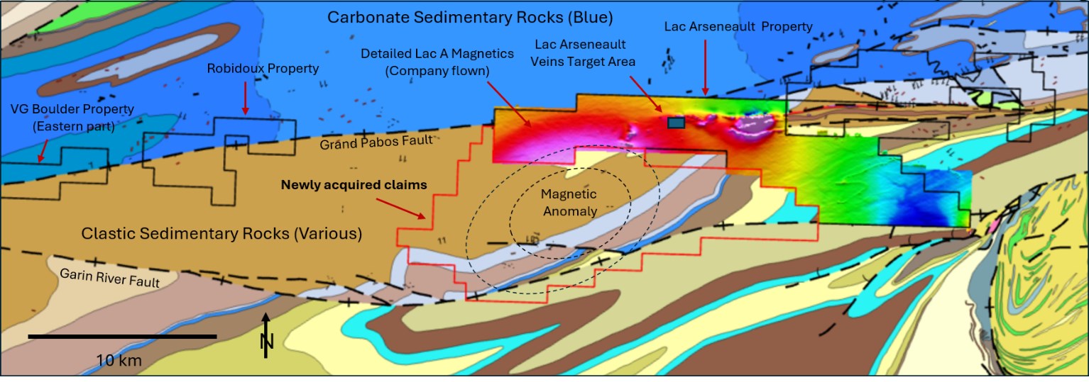
Figure 1: Newly acquired claims south of Lac Arsenault and Robidoux, showing principal regional structures and magnetic data
To view an enhanced version of this graphic, please visit:
https://images.newsfilecorp.com/files/11663/312886_6c25bcbbe4c609fc_001full.jpg

To view the source version of this press release, please visit https://www.newsfilecorp.com/release/312886
FAQ
AI-generated questions and answers. How Rhea-AI works. Not financial advice.