
Founders Metals Hits 12.95 g/t Gold over 6.0 m Confirming High-Grade Gold Potential at Lower Antino
Rhea-AI Summary
Founders Metals (OTCQX: FDMIF) reports high-grade drill results at the Lower Antino target, including 6.0 m of 12.95 g/t Au from 55.0 m (LA060), plus a 200 m south step-out intercept of 18.0 m of 0.68 g/t Au from 59.1 m (LA054). Drilling extends mineralization ~250 m west and confirms broad tonalite-hosted mineralization along strike. Four diamond rigs are active across the Antino district; additional assays and modelling are underway to refine geometry and continuity.
Positive
- 6.0 m of 12.95 g/t Au (LA060) — highest Lower Antino drill composite
- High-grade interval extends mineralization ~250 m west
- 18.0 m of 0.68 g/t Au from 59.1 m (LA054) in 200 m step-out
- Broad intercepts confirm continuous tonalite-hosted mineralization along strike
- Four diamond rigs operating across the Antino district
Negative
- Most wide intercepts are low-grade (e.g., LA055: 56.10 m @ 0.28 g/t Au)
- Interval averages use un-capped assays; capping levels not yet established
- True widths estimated (~85%) — geometry and continuity still uncertain
News Market Reaction – FDMIF
In the Apr 30 session, FDMIF declined 2.04%, reflecting a moderate negative market reaction.
Data tracked by StockTitan Argus on the day of publication.
AI-generated analysis. How Rhea-AI works. Not financial advice.




Vancouver, British Columbia--(Newsfile Corp. - April 30, 2026) - Founders Metals Inc. (TSXV: FDR) (OTCQX: FDMIF) (FSE: 9DL0) ("Founders" or the "Company") reports high-grade gold results from the Lower Antino Target at its Antino Gold Project ("Antino" or the "Project") in southeastern Suriname (Figure 1). Results include 6.0 metres (m) of 12.95 grams per tonne (g/t) gold (Au) - a significant high-grade intercept at Lower Antino - while continued systematic drilling expands the mineralized system along strike.
Colin Padget, President & CEO, commented, "The 6.0 metres of 12.95 g/t gold in LA060 is an important result for Lower Antino. While the system has consistently delivered broad, lower-grade mineralization, this intercept suggests the presence of a higher-grade component - a characteristic we have been actively testing for. Additional drilling in this release continues to grow the mineralized extent of Lower Antino, and we will incorporate these results into our geological models to better define the geometry and continuity of mineralization as the program advances."
Highlights
- High-grade drill-confirmed intercept near surface at Lower Antino confirms high-grade component within the tonalite-hosted gold system:
- 6.0 m of 12.95 g/t Au from 55.0 m (LA060)
- Intercept extends mineralization approximately 250 m west of the nearest previous drilling
- Continued systematic drilling expands the mineralized system with wide intercepts along strike:
- Drilling to the east confirms continued growth of the mineralized system (LA055, LA056) (Figure 2)
- 200 m step-out to the south intersects intrusion-hosted mineralization with 18.0 m of 0.68 g/t Au from 59.1 m (LA054)
Geological Discussion
The westernmost hole in this release, LA060, intersected 6.0 m of 12.95 g/t Au from 55.0 m depth, delivering the highest-grade composite interval returned from Lower Antino drilling to date and extending mineralization approximately 250 m to the west. This result confirms the presence of a high-grade shear-related component within the broader tonalite-hosted gold system, consistent with previously reported historical high-grade channel and grab sample results, but that had not yet been confirmed by drilling.
Systematic step-out drilling to the east and south continues to expand the mineralized footprint. Holes LA055 and LA056 confirm broad, consistent gold mineralization along strike to the east, while LA054 intersected gold mineralization in a 200 m step-out to the south. Sheared and altered tonalite intrusions have been observed in multiple holes with assays pending between known mineralized corridors. Holes LA051 and LA052, the farthest south holes at Lower Antino to date, are interpreted to have been drilled east of the mineralized tonalite bodies.
Lower Antino is one of two Advanced Targets within Founders' 102,360-hectare contiguous land package, which hosts eight drill-tested gold targets across the 55 km long Antino concession. The Company currently has four diamond drill rigs operating at Antino, with two rigs at Antino North, one at Upper Antino, and one at Lower Antino, with results pending at all locations. The Company will continue to systematically advance its highest-priority targets across the district.
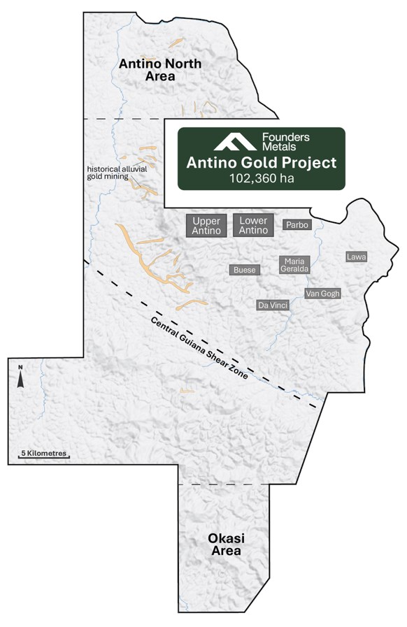
Figure 1: Antino Gold Project Property Map
To view an enhanced version of this graphic, please visit:
https://images.newsfilecorp.com/files/7574/295168_be3d3fa8d4df5acc_001full.jpg
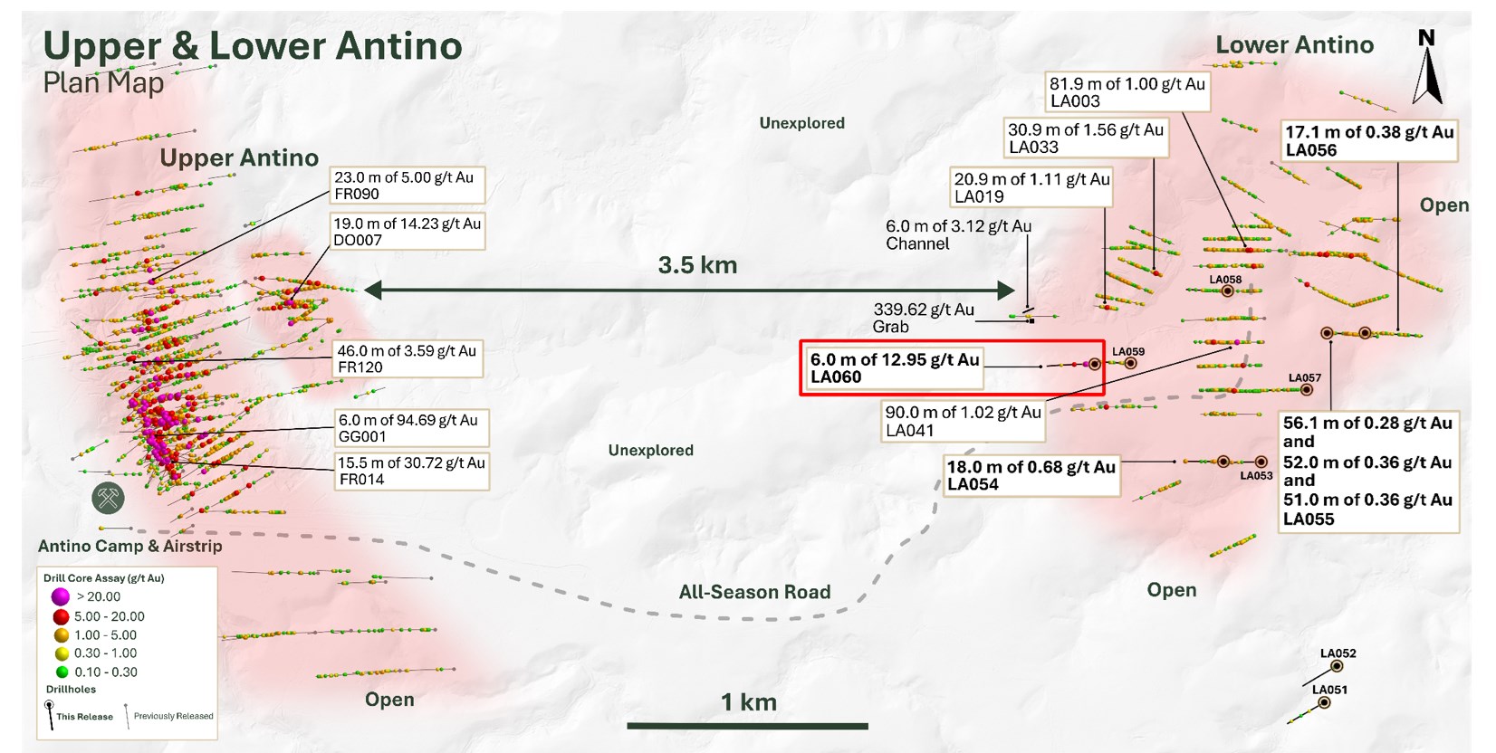
Figure 2: Lower Antino Plan Map
To view an enhanced version of this graphic, please visit:
https://images.newsfilecorp.com/files/7574/295168_be3d3fa8d4df5acc_002full.jpg
Table 1: Drill Hole Assay Results
| Drillhole | From (m) | To (m) | Interval (m) | Au (g/t) |
| LA051 | NSA | |||
| LA052 | NSA | |||
| LA053 | NSA | |||
| LA054 | 59.10 | 77.10 | 18.00 | 0.68 |
| incl. | 59.10 | 62.10 | 3.00 | 2.70 |
| and | 243.00 | 246.00 | 3.00 | 1.71 |
| LA055 | 0.00 | 56.10 | 56.10 | 0.28 |
| incl. | 33.60 | 42.60 | 9.00 | 1.13 |
| and | 102.00 | 154.00 | 52.00 | 0.36 |
| and | 162.00 | 213.00 | 51.00 | 0.36 |
| and | 264.00 | 274.00 | 10.00 | 0.30 |
| LA056 | 0.00 | 17.10 | 17.10 | 0.38 |
| and | 102.00 | 117.00 | 15.00 | 0.27 |
| and | 218.00 | 224.00 | 6.00 | 0.21 |
| and | 241.00 | 247.00 | 6.00 | 0.46 |
| LA057 | 118.00 | 127.00 | 9.00 | 0.37 |
| and | 308.00 | 316.00 | 8.00 | 0.40 |
| LA058 | 159.00 | 165.00 | 6.00 | 0.29 |
| LA059 | 0.00 | 8.10 | 8.10 | 0.24 |
| and | 59.00 | 67.00 | 8.00 | 0.20 |
| and | 124.00 | 128.00 | 4.00 | 0.42 |
| LA060 | 55.00 | 61.00 | 6.00 | 12.95 |
| incl. | 56.00 | 59.00 | 3.00 | 25.70 |
| and | 128.00 | 132.00 | 4.00 | 2.03 |
*Intervals are down-hole depths. True widths of mineralization are estimated to be approximately
Table 2: Drill Hole Locations
| Hole ID | Easting (m) | Northing (m) | Elevation (m) | Azimuth (°) | Dip (°) | Depth (m) |
| LA051 | 821874.33 | 399865.00 | 135.00 | 240.40 | -50.30 | 275.00 |
| LA052 | 821926.67 | 400017.00 | 144.55 | 240.40 | -50.00 | 251.21 |
| LA053 | 821612.00 | 400866.67 | 138.58 | 270.10 | -49.90 | 251.29 |
| LA054 | 821454.60 | 400868.00 | 159.90 | 270.00 | -50.30 | 251.15 |
| LA055 | 821885.33 | 401403.00 | 136.51 | 90.20 | -50.30 | 314.12 |
| LA056 | 822043.67 | 401403.67 | 112.89 | 90.00 | -50.00 | 353.48 |
| LA057 | 821801.00 | 401167.50 | 160.93 | 270.10 | -50.30 | 338.00 |
| LA058 | 821472.33 | 401578.67 | 130.68 | 270.30 | -50.20 | 266.15 |
| LA059 | 821068.67 | 401278.00 | 146.41 | 270.30 | -50.20 | 251.00 |
| LA060 | 820919.33 | 401273.50 | 131.64 | 270.40 | -50.30 | 290.00 |
About Founders Metals Inc.
Founders Metals Inc. is a Canadian gold exploration company building a district-scale gold camp in southeastern Suriname. The Company controls a 102,360-hectare contiguous land package in the Guiana Shield - the largest uninterrupted package of highly prospective greenstone belt geology in the region. Founders is backed by strategic partnerships with Gold Fields and B2Gold and is executing one of the most active exploration programs in the global junior gold sector. The Company is committed to responsible exploration, strong community engagement, and disciplined capital allocation as it advances Suriname's next major gold camp.
ON BEHALF OF THE BOARD OF DIRECTORS,
Per: "Colin Padget"
Colin Padget
President, Chief Executive Officer, and Director
Contact Information
Katie MacKenzie, Vice President, Corporate Development
Tel: +1 306 537 8903 | katiem@fdrmetals.com
Cautionary Statement Regarding Forward-Looking Information
This press release contains "forward-looking information" within the meaning of applicable Canadian securities legislation, including statements regarding the Company's exploration plans, anticipated drilling results, and the Company's prospects. Forward-looking information can generally be identified by words such as "plans", "expects", "is expected", "budget", "scheduled", "estimates", "forecasts", "intends", "anticipates", "believes", or variations indicating that certain actions, events or results "may", "could", "would", "might" or "will" occur or be achieved.
Forward-looking statements are based on management's current expectations and reasonable assumptions but are subject to business, market, and economic risks, uncertainties, and contingencies that may cause actual results to differ materially from those expressed or implied, including: general business and economic uncertainties; exploration results; mining industry risks; and other factors described in the Company's most recent annual management discussion and analysis. Although the Company has attempted to identify important factors that could cause actual results to differ materially, other factors may cause results not to be as anticipated. There can be no assurance that forward-looking information will prove accurate, as actual results and future events could differ materially from those anticipated. Accordingly, readers should not place undue reliance on forward-looking information. The Company does not undertake to update any forward-looking information except in accordance with applicable securities laws. Neither TSX Venture Exchange nor its Regulation Services Provider (as that term is defined in policies of the TSX Venture Exchange) accepts responsibility for the adequacy or accuracy of this release.
All material information on Founders Metals can be found at www.sedarplus.ca.
Quality Assurance and Control
Drill holes are drilled as NQ- and HQ-diameter diamond core. Core is sawed in half, with one half submitted for assay and the other retained for reference. Samples were analyzed at FILAB Suriname, a Bureau Veritas Certified Laboratory in Paramaribo, Suriname (a commercial certified laboratory under ISO 9001:2015). Samples are crushed to
Qualified Persons
The technical content of this news release has been reviewed and approved by Michael Dufresne, M.Sc., P.Geol., P.Geo., an independent qualified person as defined by National Instrument 43-101.

To view the source version of this press release, please visit https://www.newsfilecorp.com/release/295168