Future Fuels Unlocks Historic Geophysical Survey Data; Marketing Update
Rhea-AI Summary
Future Fuels (TSXV:FTUR, OTCQB:FTURF) announced it has acquired high-resolution geophysical data covering the Mountain Lake system at its wholly owned Hornby Basin Project, located approximately 95 kilometres southwest of Kugluktuk, Nunavut. The company said it will immediately re-process and integrate the dataset into Vrify's DORA AI platform to produce the first high-resolution geophysical coverage directly over Mountain Lake.
Future Fuels expects the digitized, AI-processed data to help identify geophysical signatures tied to known mineralization and to generate new high-priority drill targets across its district-scale land position.
Positive
- High-resolution geophysical data acquired for Mountain Lake system
- Dataset covers Hornby Basin area ~95 kilometres southwest of Kugluktuk
- Immediate reprocessing planned using Vrify DORA AI platform
- Objective to identify geophysical signatures and new drill targets
Negative
- None.
News Market Reaction – FTURF
In the Oct 7 session, FTURF gained 0.05%, reflecting a mild positive market reaction.
Data tracked by StockTitan Argus on the day of publication.
AI-generated analysis. How Rhea-AI works. Not financial advice.
VANCOUVER, BC, BC / ACCESS Newswire / October 6, 2025 / Future Fuels Inc. (TSXV:FTUR)(FSE:S0J)(OTCQB:FTURF) ("Future Fuels" or the "Company") is pleased to announce that it has acquired high resolution geophysical data that covers the Mountain Lake System at its wholly owned Hornby Basin Project (the "Hornby Project" or the "Project"), located approximately 95 kilometres southwest of Kugluktuk, Nunavut Territory.
Future Fuels CEO, Rob Leckie commented "One of our primary objectives for the Mountain Lake project has been the consolidation and digitization of historic data generated during prior exploration campaigns. Over the past decades, various operators spent substantial time, effort and money generating data that was never properly consolidated. Our ongoing efforts to secure and process this data represents a significant step forward for our exploration program. We will be immediately re-processing and integrating it into Vrify's DORA AI platform, giving us high-resolution geophysical coverage directly over the Mountain Lake system for the first time. Our hope is that this will allow for the identification of geophysical signatures associated with known mineralization and the application of those patterns across our broader district-scale land position. This is why digitization, advanced AI, and machine learning tools are a core part of our exploration strategy; Future Fuels can now systematically evaluate Mountain Lake and the Hornby Basin in a manner that was previously impossible. We believe this dataset will unlock new high-priority drill targets across the property."
About The Historical Geophysical Survey
The Airborne Mega Transient Electromagnetic (MEGATEM) survey was conducted by Pitchstone Exploration and Triex Minerals two decades ago but was never submitted to the Nunavut Geoscience Database. As a result, this data was inaccessible to Future Fuels until now.
In May 2005, Fugro Airborne Surveys flew 684 line kms of MEGATEM electromagnetics and magnetics at 150m line spacings. This is the highest resolution airborne survey ever to be completed at the Hornby Project. The Electromagnetic system was a MEGATEM 20 channel multicoil system flown at a height of 120m above the ground.
MEGATEM are airborne transient (or time domain) towed-bird EM systems incorporating a high-speed digital receiver which records the secondary field response with a high degree of accuracy. The response is generated by eddy currents in conductors. The resulting EM response can be interpreted to identify the probable origin of the source conductors. There are various types of conductors, but graphitic horizons in the bedrock are the primary target. These graphitic zones are often associated with unconformity style uranium deposits. The Company had Fugro's interpretation of the data, as this was documented as an appendix to the 2006 assessment report (085069) but lacked the digital version which prevented integration with the ongoing re-interpretation work and use within the Vrify DORA AI analysis and platform.
The key highlights from the 2005 report completed by Fugro were:
The magnetic field products showed several strong magnetic bodies with numerous weak short wavelength bodies filling around the dominant features. This abundance of strong gradients seen in the first derivative product indicated the area had undergone strong structural deformation and faulting. This is an important component required for unconformity style deposits hosted at the contact between the overlying sediments and basement.
The EM products identified five significant conductors in the survey area which showed evidence of structural control from the magnetic data. These conductors were recommended for follow up.
The airborne magnetic and EM survey highlighted several interesting observations. The magnetic survey shows a sharp NE-SW boundary between rocks with a strong magnetic signature (on NW side) and rocks of variable weak to moderate magnetic signature (SE side). This boundary correlates well with the main trace of the NE trending, vertical dipping Helmut Fault and associated splays. On the SW side of the Helmut Fault, where the magnetic signature is variably weak to moderate, most of the changes in magnetic variability correspond to mapped and interpreted faults. It is likely that the magnetic signature picked up on the survey represents basement rock (i.e. below the Dismal Lake sandstone stratigraphy). As very few holes went deep enough to intersect the basement rock, it is not clear whether the different magnetic intensity is a function of the block faulted nature of the same basement rock, or different rock units that make up the basement.
The Mountain Lake System occurs within a NE-SW trending zone of moderate magnetic intensity signature, separated from a narrow zone of weak magnetic intensity to the NW. This change in magnetic intensity from weak to moderate is coincident with the trace of the NE trending vertical Imperial Fault. It is suspected that the proximity to these major faults has a direct impact on the control of the uranium mineralization. The magnetic survey seems to be very good at showing the traces of the various faults and highlighting the underlying basement magnetic signature of the Mountain Lake System itself.
The airborne EM survey shows that the faults believed to be important controls in mineralization are subtle conductors. Based on the airborne geophysical work, the faults themselves may represent a mineralized uranium target.
Historical Data Product and Next Steps
The data is currently being re-processed and will be incorporated into the learning data sets for the DORA AI platform with Vrify. It is anticipated that this additional data layer will enable the DORA algorithm to generate valuable insights that can help guide future exploration and target generation.
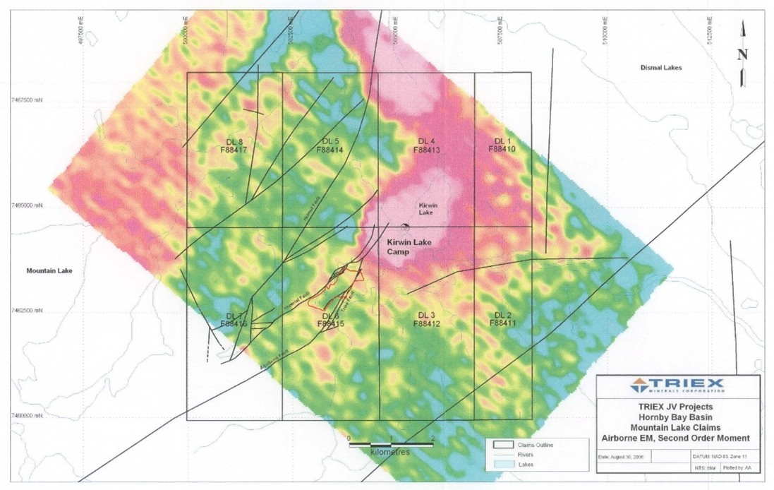
Figure 1: Mountain Lake airborne MEGATEM Survey, 2nd Order Moment: Magenta-Blue represents high-low conductivity (After Armitage, 2006)
References
Armitage, A. E. (2006). 2005 Airborne Geophysical surveys, on the mountain lake property, Prepared for Triex Minerals Corporation, Nunavut assessment report 085069
Marketing Update
Further to the Company's March 11, 2025 and September 5, 2025 news releases, the Company also wishes to announce that it has increased the maximum budget of its renewed September 5, 2025 engagement with MCS Market Communication Service GmbH ("MCS") for the continued provision of a range of on-line marketing services, including campaign creation and production of marketing materials, as well as research and analytics, by up to an additional 155,000 euros. The services are expected to run until November 6, 2025, or until budget exhaustion. No securities have been provided to MCS or its principals as compensation.
National Instrument 43-101 Disclosure
Nicholas Rodway, P. Geo, (NAPEG Licence # L5576) is a consultant of the Company and is a qualified person as defined by National Instrument 43-101 - Standards of Disclosure for Mineral Properties. Mr. Rodway has reviewed and approved the technical content in this release.
About Future Fuels Inc.
Future Fuels' principal asset is the Hornby Project, covering the entire 3,407 km² Hornby Basin in north-western Nunavut, a geologically promising area with over 40 underexplored uranium showings, including the historic Mountain Lake System. Additionally, Future Fuels holds the Covette Project in Quebec's James Bay region, comprising 65 mineral claims over 3,370 hectares.
On behalf of the Board of Directors
FUTURE FUELS INC.
Rob Leckie, CEO and Director
info@futurefuelsinc.com
604-681-1568
X: @FutureFuelsInc
www.futurefuelsinc.com
Forward Looking Statements
Neither the TSX Venture Exchange nor its Regulation Service Provider (as that term is defined in the policies of the TSX Venture Exchange) accepts responsibility for the adequacy or accuracy of this release.
This news release contains forward-looking statements and other statements that are not historical facts. Forward-looking statements are often identified by terms such as "will", "may", "should", "anticipate", "expects" and similar expressions. All statements other than statements of historical fact included in this news release are forward-looking statements that involve risks and uncertainties. There can be no assurance that such statements will prove to be accurate and actual results and future events could differ materially from those anticipated in such statements. Important factors that could cause actual results to differ materially from the Company's expectations include but are not limited to market conditions and the risks detailed from time to time in the filings made by the Company with securities regulators, available under its profile at www.sedarplus.ca. The reader is cautioned that assumptions used in the preparation of any forward-looking information may prove to be incorrect. Events or circumstances may cause actual results to differ materially from those predicted, as a result of numerous known and unknown risks, uncertainties, and other factors, many of which are beyond the control of the Company. The reader is cautioned not to place undue reliance on any forward-looking information, including, but not limited to, statements regarding the Hornby Project, the prospects of the mineral claims forming the Hornby Project, which are not at an advanced stage of development, the Company's anticipated business and operational activities, and the Company's plans with respect to the exploration or advancement of the Hornby Project. Factors that could cause actual results to vary from forward-looking statements or may affect the operations, performance, development and results of the Company's business include, among other things, the Company's ability to generate sufficient cash flow to meet its current and future obligations; that mineral exploration is inherently uncertain and may be unsuccessful in achieving the desired results; that mineral exploration plans may change and be re-defined based on a number of factors, many of which are outside of the Company's control; the Company's ability to access sources of debt and equity capital; competitive factors, pricing pressures and supply and demand in the Company's industry; and general economic and business. Such information, although considered reasonable by management at the time of preparation, may prove to be incorrect and actual results may differ materially from those anticipated. Forward-looking statements contained in this news release are expressly qualified by this cautionary statement. The forward-looking statements contained in this news release are made as of the date of this news release and the Company will update or revise publicly any of the included forward-looking statements as expressly required by applicable law.
SOURCE: Future Fuels Inc.
View the original press release on ACCESS Newswire