
Skeleton Coast Uranium Completes Digitisation of Historical Exploration Data for Its Five Namibian EPLs and Defines Priority Target Areas for Field Validation
Field validation depends on landowner access, park entry permits and environmental clearances across the licence portfolio.
Sentiment and the balance of points
Rhea-AI Sentiment reads the wording of the document, how positive or negative its language is on a 1 to 5 scale. The balance of points shown with the takes weighs what the document actually discloses, so the two can disagree, for example when a trial that missed its main goal is described in upbeat language.
Rhea-AI Summary
Skeleton Coast Uranium (GLIIF) completed historical exploration data digitisation for its five Namibian prospecting licences and defined priority field-validation targets. Practara consolidated approximately 140 historical sheets into one geographically referenced dataset, completing Phase 1 data consolidation and target definition. Targets cover granite-associated uranium and uranium in ancient drainage channels.
Regional airborne magnetic and radiometric data reprocessing is complete; ranked uranium targets will be released once finalised. The company plans Phase 2 field validation on EPL 8617 in the fourth quarter of 2026, subject to landowner access agreements. Park entry permits are pending for subsequent work, and EPLs 9872 and 9873 still require environmental clearance. Historical information is unverified, targets are conceptual, and exploration has not defined a mineral resource on any licence.
How this balance works
Rhea-AI gives every point it takes from this document a weight. Minor counts 1, Moderate 3 and Major 9, so one Major point outweighs several Minor ones. The bar adds up the weights on each side, and when neither side holds more than 65% of the total the balance reads Mixed.
It reads the document as published, with the same rules for every company, and it does not look at what the market expected or at how the stock traded, so a point can be objectively good on a day the stock falls.
Rhea-AI Sentiment measures something else, the tone of the wording.
Hollow bars mark forward-looking points. How the balance works
Positive
- Minor pointPhase 1 data consolidation and target definition completed across all five licences.
- Minor pointApproximately 140 historical sheets consolidated into a geographically referenced exploration dataset.
- Minor point. Forward-looking: it has not happened yet and may not happen.Regional airborne data reprocessing completed; ranked uranium targets will be released once finalised.
- Minor pointEPL 8617 targets defined along the Valencia-Khan corridor and northern ancient drainage valley.
- Minor pointEPL 8208 targets defined in the ancient drainage corridor, Etusis dome and eastern Salem granite.
3 minor points
- Minor pointEPL 9727 targets defined in northeastern drainage-related cover and southwestern granite-associated terrain.
- Minor pointEPLs 9872 and 9873 targets defined in terrace and ancient valley cover and granite belts.
- Minor point. Forward-looking: it has not happened yet and may not happen.Phase 2 field validation planned for fourth-quarter 2026, beginning on EPL 8617.
Negative
- Moderate pointEPL 8617 fieldwork depends on landowner access agreements that remain to be concluded.
- Minor pointPark entry permits remain pending before EPL 9727 and licences within Namib-Naukluft National Park follow.
- Minor pointEPLs 9872 and 9873 lack required environmental clearance certificates, preventing fieldwork until granted.
- Minor pointHistorical technical information remains independently unverified and should not be relied upon.
- Minor pointTargets are conceptual; insufficient exploration has defined a mineral resource on any licence.
2 minor points
- Minor pointLanger Heinrich district drilling lies outside EPL 8208 and does not establish mineralisation within it.
- Minor pointEPLs 9872 and 9873 had the least historical coverage in the archive.
AI-generated analysis. How Rhea-AI works. Not financial advice.




Following the first phase announced on August 18, 2026, Practara (Pty) Ltd has completed the second and final phase of the digitisation of historical exploration data, extending the compilation to EPLs 9872 and 9873, and consolidating the archive for all five EPLs into a single georeferenced GIS dataset of approximately 140 digitised historical sheets, delivered in GeoPackage and Google Earth formats with a descriptive index.
The compiled dataset includes approximately 72 historical map products for the EPL 8208 area and about 1,131 historical drillhole positions from the Langer Heinrich district adjoining EPL 8208, captured with overburden and mineralised thickness attributes where recorded, together with historical licence, work area and survey boundaries across the portfolio.
The compilation completes the Phase 1 data consolidation and target definition recommended in the Company's NI 43-101 Technical Reports (announced August 4, 2026) and has defined priority target areas on each licence under the Company's dual prospectivity model: primary leucogranite-associated uranium analogous to Rössing and Husab, and secondary calcrete-hosted palaeochannel uranium analogous to Langer Heinrich.
On this base the Company commissioned the reprocessing and reinterpretation of the government's regional airborne magnetic and radiometric data over all five licences, referred to on August 18, 2026; the Company will release these results once finalised. Phase 2 field validation is planned to begin in the fourth quarter of 2026 on EPL 8617, where the licence overlies freehold farmland, subject to the conclusion of access agreements with the landowners.
Namibia accounted for approximately
12% of global mined uranium production in 2024 and ranks among the world's top three producing countries (World Nuclear Association).
Vancouver, British Columbia--(Newsfile Corp. - October 1, 2026) - Skeleton Coast Uranium Corp. (TSXV: SKEL) (OTC: GLIIF) (FSE: KDM0) (the "Company" or "Skeleton Coast Uranium") is pleased to announce that Practara (Pty) Ltd ("Practara") has completed the digitisation of the historical exploration data for the Company's five Exclusive Prospecting Licences ("EPLs") in the Erongo Region of Namibia, completing the Phase 1 data consolidation and target definition recommended in the Company's Technical Reports, and that interpretation of the compiled data has defined priority target areas on each licence for field validation. The first phase of the digitisation programme, covering EPLs 8617, 8208 and 9727, was announced on August 18, 2026.
Historical Data Digitisation Programme
The digitisation programme recovered a heterogeneous archive of scanned historical exploration sheets held for the licences and the surrounding district, comprising regional and prospect scale geological mapping, historical exploration reports, regional airborne geophysics, ground radiometric and geophysical surveys, geochemical sampling and historical drilling records, and converted it into a consistent, spatially referenced digital dataset. Each sheet was reviewed, classified by data type (drilling, geochemistry, geophysics, geology, locality and general), and, where the available control allowed, georeferenced to WGS84 UTM Zone 33S and digitised in QGIS. Sheets that could not be georeferenced, duplicates, sheets without data values and cross sections lacking vertical control were tagged and excluded, with the reason recorded, so that the exclusions are auditable and can be revisited if further control becomes available.
The second phase completed the compilation for EPLs 9872 and 9873, reconciled the full set of digitised sheets against a descriptive index recording the content, units and source licence of each file, and integrated the dataset into the Company's Phase 1 geographic information system together with the regional geological mapping, the historical uranium occurrence and prospect positions (including Welwitschia Flats), the structural lineament interpretation from the reprocessed magnetic data and the target zones of the 2024 prospectivity assessment of EPL 8208 and its former eastern extension, as recommended for EPL 9727 and EPL 8208 in the Technical Reports. For the Langer Heinrich district adjoining EPL 8208, approximately 72 historical map products were reviewed or digitised and about 1,131 historical drillhole positions were captured, with the historical overburden and mineralisation isopachs and value contours, to provide the regional context and the exploration analogue for the calcrete hosted model; these data are not evidence of mineralisation within EPL 8208. In total, approximately 140 historical sheets were georeferenced and digitised: about 75 covering EPL 8208, EPL 9727 and the adjoining Langer Heinrich district, about 45 covering EPL 8617 and about 20 covering EPLs 9872 and 9873; a further 30 sheets were reviewed but excluded as duplicates or for lack of coordinate control. The compiled data for EPLs 8617, 8208 and 9727 are shown in Figures 1 to 3. Outputs are delivered as GeoPackage files, the open, single file GIS format, and as Google Earth (KMZ) files for straightforward viewing, and are held in a controlled technical data room together with the current licence and cadastral boundaries, the environmental approvals and the landowner and access records.
Priority Target Areas
Each of the Company's projects offers dual prospectivity for primary leucogranite-associated uranium mineralisation analogous to the Rössing and Husab deposits, and secondary calcrete-hosted palaeochannel uranium mineralisation analogous to the Langer Heinrich deposit. Interpretation of the compiled data within the geological framework set out in the Technical Reports, together with the Company's prospectivity assessment of the licences, has defined the following priority target areas for ground follow up.
EPL 8617
EPL 8617 (10,491.5 hectares) lies in the southern Central Zone of the Damara Orogen, approximately 18 km east of the Rössing mine and 17 km east of the Husab mine. The structurally prepared Damara metasediments and alaskites of the Valencia-Khan corridor project into the licence, and historical records reference radiometric anomalies along the trend that may indicate alaskite hosted uranium mineralisation. The compiled data define two target areas: the Valencia-Khan structural corridor for primary leucogranite associated mineralisation, and the north trending palaeovalley in the north of the licence, where cover and drainage geometry favour secondary calcrete hosted mineralisation. EPL 8617 is held under farm title and is the Company's first priority for ground work (Figure 1).
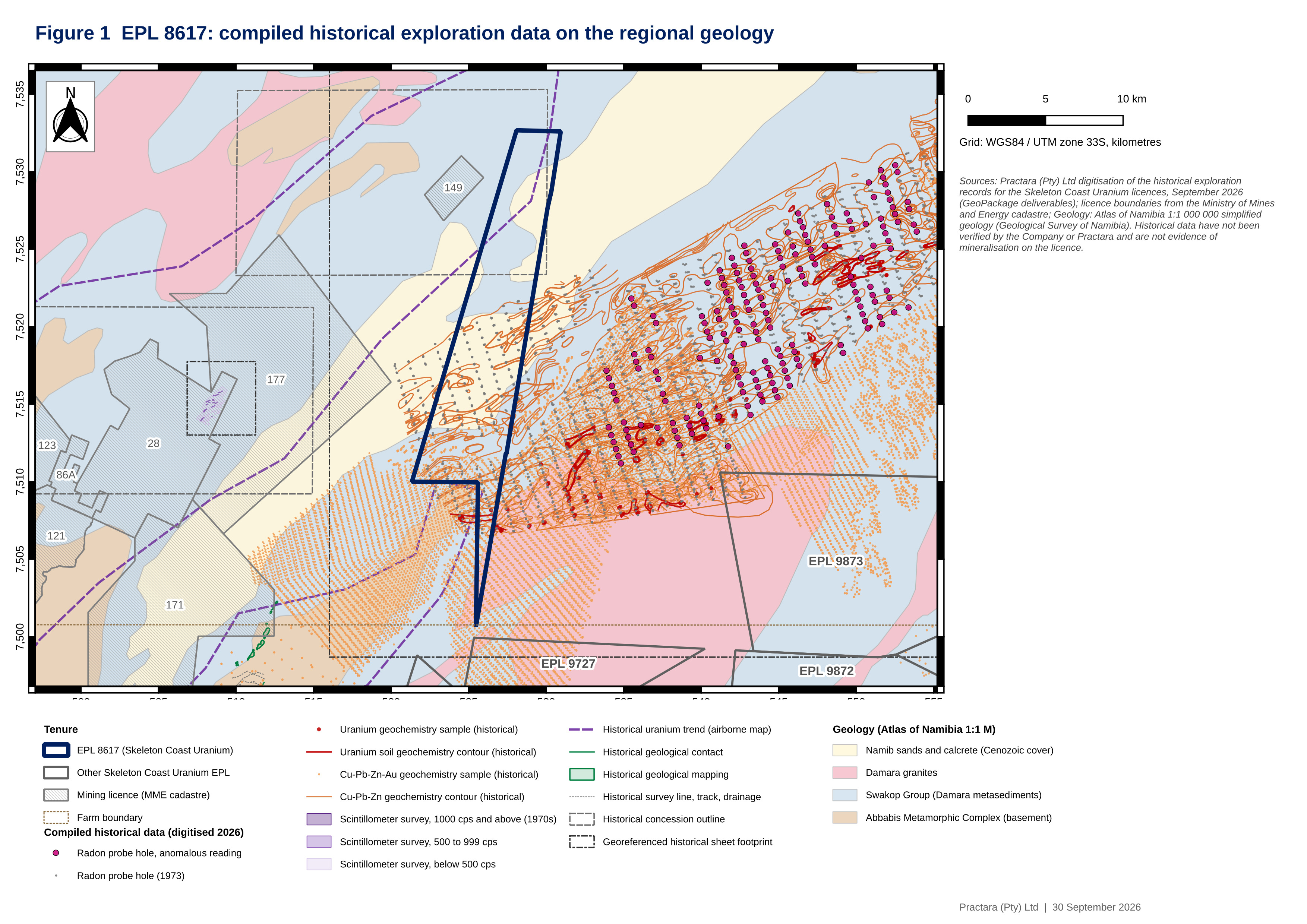
Figure 1. EPL 8617: compiled historical exploration data on the Atlas of Namibia 1:1 million geology. Historical data are shown for context and have not been verified by the Company.
To view an enhanced version of this graphic, please visit:
https://images.newsfilecorp.com/files/890/316809_skeletoncoast1figure.jpg
EPL 8208
EPL 8208 (7,840.7 hectares) is contiguous along its southern boundary with the mining licences hosting the Langer Heinrich mine. The compiled historical record, including the digitised Langer Heinrich district drilling, defines the palaeochannel corridor between the Etusis dome and the Langer Heinrich boundary as the priority target for secondary calcrete hosted mineralisation, with interpreted tributaries to the Langer Heinrich palaeochannel system displaying elevated historical radiometric responses. The Etusis dome and the Salem granite in the east of the licence are the target area for primary mineralisation (Figure 2).
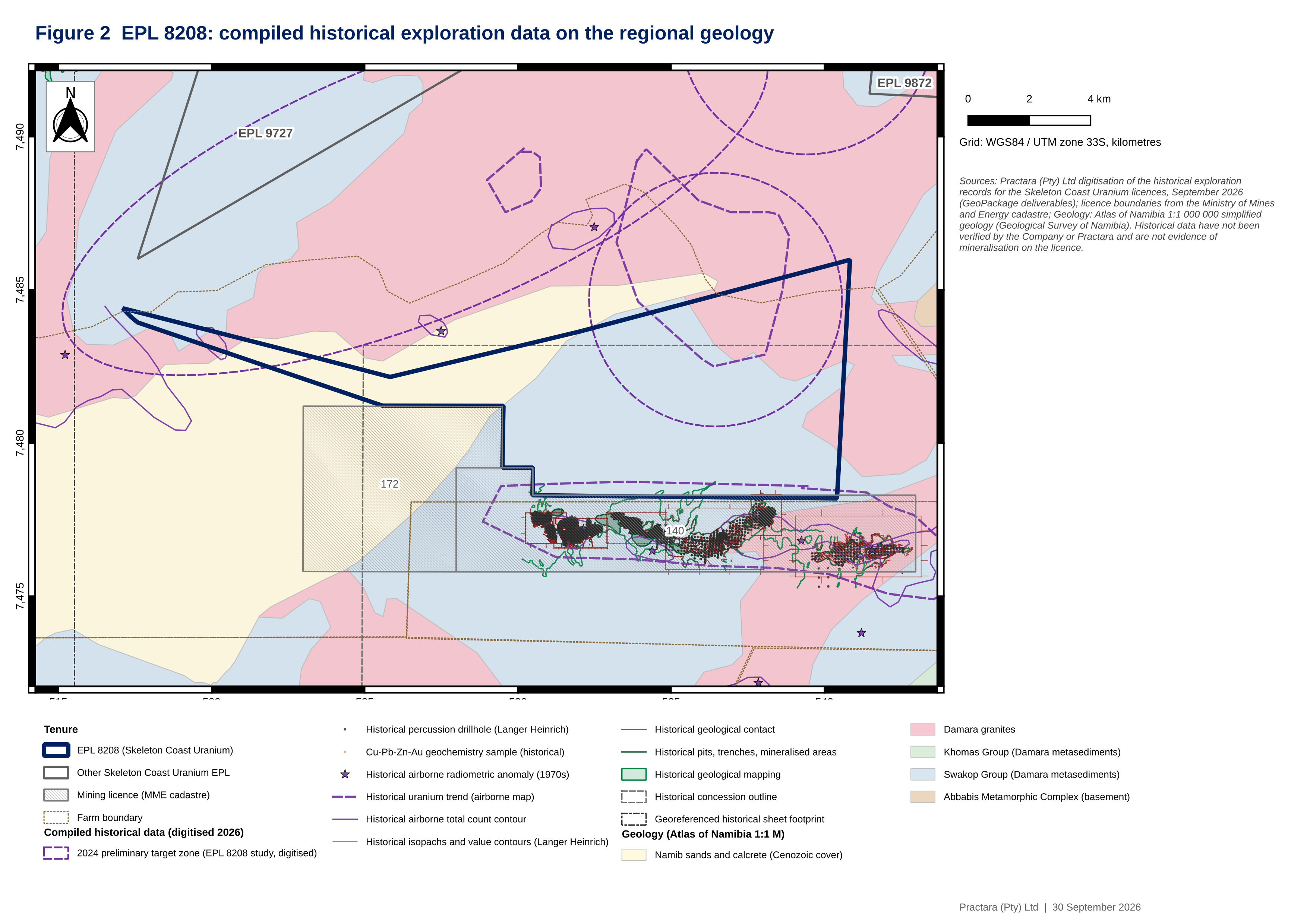
Figure 2. EPL 8208: compiled historical exploration data, including the digitised Langer Heinrich district drilling south of the licence boundary, and the 2024 preliminary target zones on the regional geology. The Langer Heinrich data lie outside EPL 8208 and are not evidence of mineralisation on the licence.
To view an enhanced version of this graphic, please visit:
https://images.newsfilecorp.com/files/890/316809_skeletoncoastfigure2.jpg
EPL 9727
EPL 9727 (12,081.1 hectares) occupies a transitional setting between the two models: the north eastern sector, with Cenozoic palaeochannel related cover of the Gawib drainage system, is the target area for calcrete hosted secondary mineralisation, and the south western sector, with Damara basement lithologies including the Bloedkoppie granite and associated pegmatites, is the target area for primary leucogranite associated mineralisation. Approximately half of the licence lies within the Namib Naukluft National Park (Figure 3).
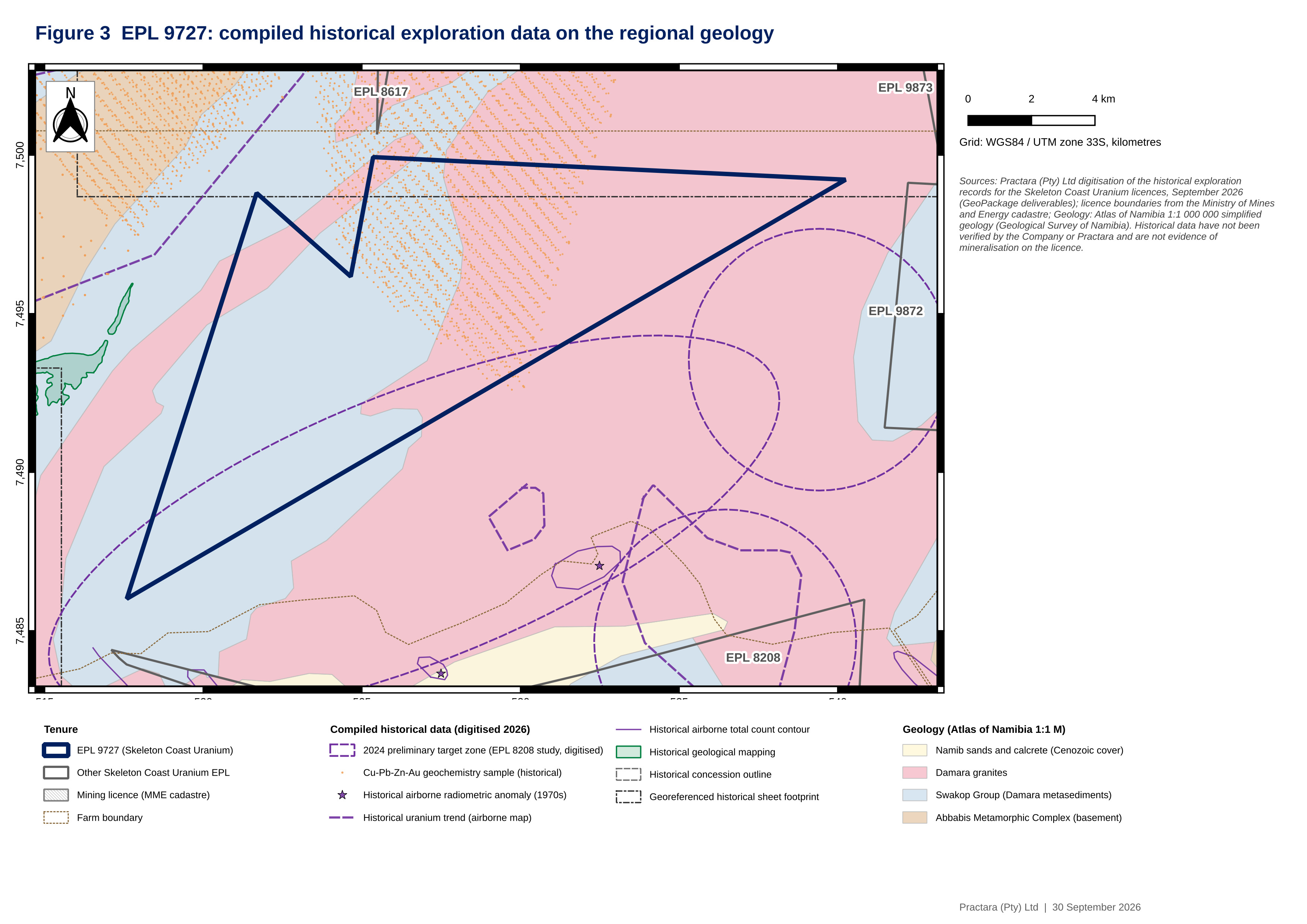
Figure 3. EPL 9727: compiled historical exploration data and the preliminary target zones of the 2024 prospectivity assessment on the regional geology.
To view an enhanced version of this graphic, please visit:
https://images.newsfilecorp.com/files/890/316809_skeletoncoastfigure3.jpg
EPLs 9872 and 9873
EPLs 9872 (11,077.9 hectares) and 9873 (19,482.1 hectares) lie east of EPL 8617 and had the least historical coverage in the archive; the compiled data define the terrace and palaeovalley cover between two north east trending granite belts on the common boundary of the two licences as the target area for secondary mineralisation, and the granite belts themselves as the primary target areas. The Namibian Ministry of Environment, Forestry and Tourism has not yet granted the required Environmental Clearance Certificates for EPLs 9872 and 9873, which are necessary for field work to be conducted.
Next Steps
With the compilation complete, the Phase 1 work recommended in the Technical Reports is finished. On the compiled base the Company commissioned ASST Namibia, an independent geophysical contractor, to reprocess and reinterpret the Namibia Ministry of Mines and Energy's regional airborne magnetic and radiometric data over all five licences, the work referred to in the Company's news release of August 18, 2026. That reprocessing work is now complete and the results are being assembled into a ranked set of airborne uranium targets across the licences, which will be released once finalised. Phase 2, the field validation of the priority target areas (scintillometer and spectrometer traverses with geological mapping, radon surveys where the radiometric source is not exposed, and geochemical sampling, followed by targeted high-resolution airborne surveys over selected ground-truthed targets), is planned to begin in the fourth quarter of 2026 on EPL 8617, where the licence overlies freehold farmland, subject to the conclusion of access agreements with the landowners, with EPL 9727 and the licences within the Namib-Naukluft National Park to follow once park entry permits are issued.
"With the digitisation completed we hold, for the first time, the full historical record of these licences in one georeferenced dataset. With this information, we have generated better exploration targets on each licence under both uranium models, and it is the base on which the reinterpretation of airborne data and this season's ground work are built," commented Dr. Nathan Chutas, Chief Executive Officer of Skeleton Coast Uranium.
Practara
Practara, a metals and mining advisory firm headquartered in South Africa, prepared the Company's technical reports entitled "NI 43-101 Technical Report on the EPL8208, Erongo Region, Namibia", "NI 43-101 Technical Report on the EPL 9727 Uranium Project, Erongo Region, Namibia" and "NI 43-101 Technical Report on the EPL 8617 Uranium Project, Erongo Region, Namibia", each with an effective date of April 22, 2026, filed on SEDAR+ and announced on August 4, 2026 (the "Technical Reports"), has compiled and digitised the historical exploration record of the Company's five EPLs and the surrounding district, and manages exploration on the licences, which combined cover approximately 60,973 hectares or 610 square kilometres.
Namibia
According to the World Nuclear Association, Namibia hosts approximately
About Skeleton Coast Uranium Corp.
Skeleton Coast Uranium holds options to acquire 70
Skeleton Coast Uranium trades on the TSX Venture Exchange under the symbol 'SKEL', on the OTC under the symbol 'GLIIF', and on the Frankfurt Stock Exchange under the symbol 'KDM0'. Additional information about Skeleton Coast Uranium can be found at www.skeletoncoasturanium.com and under the Company's profile at www.sedarplus.ca.
Qualified Person
Dr. Nathan Chutas, PhD, CPG, Chief Executive Officer of the Company, is a Qualified Person as defined by National Instrument 43-101 and has reviewed and approved the scientific and technical information contained in this news release. Dr. Chutas is a Certified Professional Geologist registered with the American Institute of Professional Geologists and is not independent of the Company within the meaning of Section 1.5 of NI 43-101.
On behalf of the Board of Directors
Skeleton Coast Uranium Corp.
Dr. Nathan Chutas, PhD, CPG
Chief Executive Officer
T: (236) 334-1660
E: info@skeletoncoasturanium.com
Technical Information
Historical technical information referenced in this news release is derived from open file exploration reports lodged with the Geological Survey of Namibia and the Ministry of Mines and Energy and from the 1988 Geological Survey of Namibia publication "The Mineral Resources of Namibia - Uranium" by H. Roesener and C.P. Schreuder. This information has not been independently verified by the Company or its Qualified Person, has not been reviewed for compliance with current sampling, analytical and quality assurance and quality control practices, and should not be relied upon; it is provided to illustrate the prior work history on the properties. The exploration targets described in this news release are conceptual in nature: there has been insufficient exploration to define a Mineral Resource on any of the EPLs and it is uncertain whether further exploration will result in the delineation of a Mineral Resource.
Information concerning the Rössing, Husab, Langer Heinrich and Etango properties is taken from the public disclosure of their operators; the Company has no interest in, or right to acquire an interest in, any of those properties, and mineralisation on adjacent or nearby properties is not necessarily indicative of mineralisation on the Company's EPLs.
Forward-Looking Information
This news release may contain certain "forward-looking information" or "forward-looking statements" within the meaning of applicable Canadian securities laws and the United States Private Securities Litigation Reform Act of 1995. When or if used in this news release, the words "anticipate", "believe", "estimate", "expect", "target", "plan", "forecast", "may", "schedule", "intend" and similar words or expressions identify forward-looking statements or information. Forward-looking statements or information in this news release may relate, but are not limited to, the continued compilation, modelling and interpretation of historical data; the identification, prioritisation and advancement of exploration targets on the Company's EPLs; the geological potential of the EPLs; the timing and scope of the planned ground exploration programme, the conclusion of land access agreements and the issue of park entry permits; and the Company's future exploration plans, expenditures and objectives in Namibia. Such statements represent the Company's current views with respect to future events and are necessarily based upon a number of assumptions and estimates that, while considered reasonable by the Company, are inherently subject to significant business, economic, competitive, political and social risks, contingencies and uncertainties, including, without limitation, the availability, accuracy and resolution of historical technical data and its interpretation; the granting of licence renewals, permits and access on acceptable terms and in the expected time; the availability of funding, contractors and equipment; exploration results that differ from expectations; risks inherent in mineral exploration activities in Namibia; and general economic, market and business conditions. Many factors, both known and unknown, could cause results, performance, or achievements to be materially different from the results, performance or achievements that are or may be expressed or implied by such forward-looking statements. The Company does not intend, and does not assume any obligation, to update these forward-looking statements or information to reflect changes in assumptions or changes in circumstances or any other events affecting such statements and information other than as required by applicable laws, rules and regulations.
Neither the TSX Venture Exchange nor its Regulation Services Provider (as that term is defined in the policies of the TSX Venture Exchange) accepts responsibility for the adequacy or accuracy of this release.

To view the source version of this press release, please visit https://www.newsfilecorp.com/release/316809
FAQ
AI-generated questions and answers. How Rhea-AI works. Not financial advice.
What did Skeleton Coast Uranium complete across its five Namibian licences?
Skeleton Coast Uranium completed Phase 1 historical data consolidation and target definition across all five licences. Practara assembled approximately 140 geographically referenced historical sheets into one dataset, supporting priority exploration targets for granite-associated uranium and uranium hosted in ancient drainage channels.
When will Skeleton Coast Uranium begin field validation on EPL 8617?
The company plans to begin field validation on EPL 8617 in the fourth quarter of 2026, subject to concluding access agreements with landowners. Work on EPL 9727 and licences within Namib-Naukluft National Park is to follow once park entry permits are issued.
How will Skeleton Coast Uranium validate its uranium exploration targets?
Phase 2 will use ground radiation measurements, geological mapping and geochemical sampling to validate priority targets. Radon surveys are planned where the radiation source is not exposed, followed by targeted high-resolution airborne surveys over selected targets checked on the ground.
How did Skeleton Coast Uranium handle unusable historical exploration sheets?
A further 30 sheets were reviewed but excluded as duplicates or for lack of coordinate control. Exclusion reasons were recorded so they can be audited and revisited if additional positioning information becomes available.