
Great Atlantic Resources Partner Commences Borehole and EM Surveys to Define Mineralized Zones at Pilley's Island Project
Great Atlantic Resources (OTC: GRARF) reports that option partner HM Exploration has started borehole and surface Time-Domain Electromagnetic (TDEM) surveys at the Pilley's Island Project in north-central Newfoundland, using contractor Crone Geophysics.
Sentiment and the balance of points
Rhea-AI Sentiment reads the wording of the document, how positive or negative its language is on a 1 to 5 scale. The balance of points shown with the takes weighs what the document actually discloses, so the two can disagree, for example when a trial that missed its main goal is described in upbeat language.
Rhea-AI Summary
Great Atlantic Resources (OTC: GRARF) reports that option partner HM Exploration has started borehole and surface Time-Domain Electromagnetic (TDEM) surveys at the Pilley's Island Project in north-central Newfoundland, using contractor Crone Geophysics. HM Exploration can earn a 100% interest in the project.
According to HM Exploration, the Surveys target potential extensions of known mineralized zones and additional conductive targets around Phase One drilling at the Clifford Jones (Bull Road) Zone. Borehole TDEM is underway in 2026 drill holes, to be followed by a surface survey of approximately 13 line kilometres over about one square kilometre.
HM Exploration states that the TDEM data will be used to refine targets and plan a Phase Two drill program anticipated for late 2026. The project hosts multiple volcanogenic massive sulphide (VMS) prospects in a road-accessible area with historic production and limited modern systematic drilling.
Positive
- HM Exploration commences borehole and surface TDEM surveys at Pilley's Island in 2026
- Planned surface EM program covers approximately 13 line kilometres over ~1 square kilometre
- Survey data intended to guide Phase Two drilling planned for late 2026
- Project hosts multiple VMS systems with historic high-grade Zn-Pb-Cu-Ag+/-Au intersections
- Road-accessible project with historic production of ~450,000 tonnes of massive pyritic ore
Negative
- None.
AI-generated analysis. How Rhea-AI works. Not financial advice.




North-Central Newfoundland
Vancouver, British Columbia--(Newsfile Corp. - August 18, 2026) - GREAT ATLANTIC RESOURCES CORP. (TSXV: GR) (the "Company" or "Great Atlantic") is pleased to announce that it's option partner HM Exploration Corp. ("HM Exploration") has commenced borehole and surface Time-Domain Electromagnetic (TDEM) surveys (collectively the "Surveys") at Great Atlantic's Pilley's Island Project, located in north-central Newfoundland, Canada. HM Exploration has contracted Crone Geophysics ("Crone") to conduct the Surveys. HM Exploration (CSE: HM) holds an option to earn a
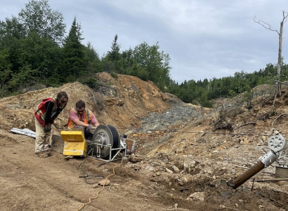
Figure 1 (by HM Exploration): Crone Geophysics personnel conducting borehole TDEM survey on drill hole PI-26-001 at the Clifford Jones (Bull Road) Zone
To view an enhanced version of this graphic, please visit:
https://images.newsfilecorp.com/files/3027/310064_1c9cf51954283b7a_002full.jpg
"VMS deposits are a globally significant source of copper, zinc, lead, silver, and gold," states Anderson, CEO of Great Atlantic. "Following the promising results generated through HM Exploration's previous drilling program, it confirms the exploration potential for the project and province. This work will provide additional information on the potential extensions of known mineralized zones, which will help identify new targets for follow up."
Highlights (as stated by HM Exploration):
- The goal of the Survey is to identify potential extensions of known mineralized zones and additional conductive targets surrounding the Phase One drilling at the Clifford Jones (Bull Road) Zone.
- TDEM is particularly effective for Volcanogenic Massive Sulphide (VMS) exploration because many volcanogenic massive sulphide deposits contain significant concentrations of conductive sulphide minerals, which can produce a measurable electromagnetic response.
- The data from the survey will provide valuable information that will assist with drill hole planning for the Phase Two drill program that is planned to take place in late 2026.
"The ongoing EM surveys will be instrumental in refining targets for our Phase Two drill program," said Nick Rodway, President and CEO of HM Exploration. "Phase One drilling confirmed continuity within both the Upper and Lower lenses. The borehole and surface EM data will help us evaluate their potential extensions and identify additional conductive targets that may represent massive sulphide mineralization. We look forward to reporting the results once the surveys and interpretation are complete."
About the TDEM Surveys (as stated by HM Exploration)
Crone Geophysics is actively conducting borehole TDEM surveys in drill holes from the Phase One drill program completed in May 2026 at the Clifford Jones (Bull Road) Zone. Upon completion of the borehole surveys, Crone will then execute a surface survey consisting of approximately 13-line kilometres covering approximately one square kilometre encompassing and expanding on ground surrounding the Phase One drill holes (Figure 2). Time-Domain Electromagnetics (TDEM) is a proven geophysical technique widely used in mineral exploration to identify and characterize electrically conductive zones in the subsurface. In VMS exploration, TDEM is particularly effective because many volcanogenic massive sulphide deposits contain significant concentrations of conductive sulphide minerals, which can produce a measurable electromagnetic response. By transmitting an electromagnetic signal into the ground and measuring the resulting decay response, TDEM surveys, such as Crone's Pulse-EM system (Figure 1), can help identify conductive anomalies that may represent massive sulphide mineralization and can provide information on their size, geometry, depth and continuity. When integrated with geological mapping, geochemistry, drilling and other geophysical data, TDEM can be an effective tool for prioritizing exploration targets and refining drill programs, potentially improving the efficiency and success of mineral exploration.
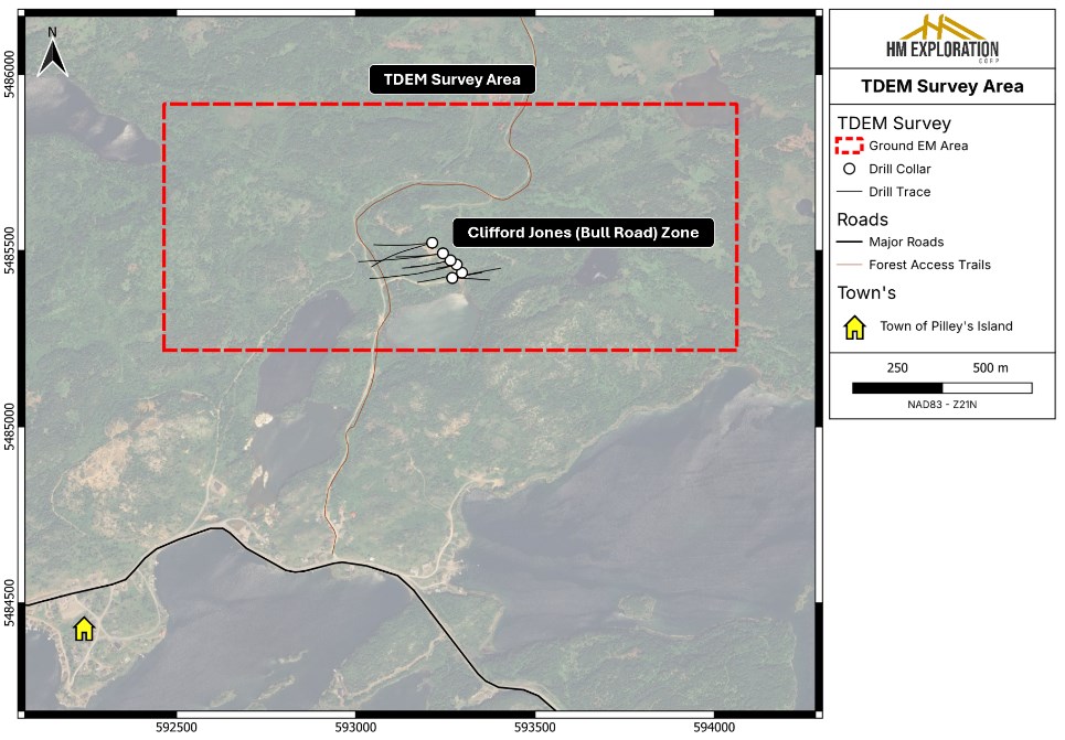
Figure 2 (by HM Exploration): Overview map of the Time-Domain Electromagnetics (TDEM) survey area at the Lewis Pilley's Project
To view an enhanced version of this graphic, please visit:
https://images.newsfilecorp.com/files/3027/310064_1c9cf51954283b7a_003full.jpg
Geology & Mineralization (as stated by HM Exploration)
The Project is located within the Notre Dame Subzone of the Dunnage Tectonostratigraphic Zone. Of note, most of the Project is underlain by Ordovician submarine volcanic rocks of the Roberts Arm Group which is regionally identified as part of a mature arc sequence referred to as the Buchans-Roberts Arm Belt that also hosts the historic Buchans mine (after Dunning et al., 1987). Mineralization occurs as lower grade (Spencer's Dock); medium grade (Old Mines); and high grade (3B-Zone/Clifford Jones) deposits that are of both sub-seafloor replacement and exhalative varieties. The deposits are often flanked by extensive chlorite, sericite, silica, K-feldspar and epidote alteration often observed in bimodal-felsic VMS systems. The Spencer's Dock area displays sericite/silica alteration that generally increases in intensity near mineralized zones, while the 3B/Old Mine areas display sericite/silica alteration that is abundant but less widespread and is more intense when proximal to mineralized zones (after Kerr, 1996).
VMS deposits are a globally significant source of copper, zinc, lead, silver, and gold. The Project's geology shares key characteristics with known VMS districts in Newfoundland, including the past producing Buchans, Ming and Rambler Mines, supporting the exploration potential of the Project.
About Lewis Pilley's Project (as stated by HM Exploration)
The Project is road accessible and situated approximately twenty-five (25) km east of the town of Springdale, approximately fifty-five (55) km southeast of Firefly Metals' Green Bay Project and approximately one hundred fifty (150) km from the Pine Cove Mill and Port by way of major roads.
The Project has a long history of mining and exploration dating back to the late 1800s when the Pilley's Island Pyrite Company Ltd. produced approximately 450,000 tonnes of massive pyritic ore from the Pilley's Island Mine-Old Mines (after Kerr, 1996).
The Project hosts a cluster of VMS systems and prospects with demonstrated high-grade Zn-Pb-Cu-Ag+/-Au intersections. Mineralization is typical bimodal-felsic VMS, with both massive sulphide and sulphide-clast breccias (Thurlow, 1996). The geological setting is directly analogous to the Buchans camp (Thurlow, 1996), and the presence of sulphide-clast breccias is a strong vector toward proximal massive sulphide lenses.
Most of the historic showings that fall within the extents of the Project have not seen systematic exploration. Many of the historic drill holes were shallow and drilled in a vertical orientation limiting the geological knowledge of the extents of the underlying lithology and mineralization. Work is being planned to validate historic assay results as well as collect new data from the 3B-Zone, Clifford Jones (Bull Road) Extension, Bouzanne Shaft, Henderson, Mansfield and Pilley's Cove Showings.
National Instrument 43-101 Disclosure (as stated by HM Exploration)
Nicholas Rodway, P.Geo, (Licence No. 46541) (Permit to Practice No. 1000359) is CEO and Director of HM Exploration, and a qualified person as defined by National Instrument 43-101- Standards of Disclosure for Mineral Projects. Mr. Rodway has supervised the preparation of and verified and approved the technical content in this news release. Verification included a review of the survey methodology, contractor information, drill hole locations and relevant geological and drilling data.
References
Dunning, G.R., Kean, B.F., Thurlow, J.G and Swinden, H.S. (1987): Geochronology of the Buchans, Roberts Arm and Victoria Lake Groups and Mansfield Cove Complex, Newfoundland. Canadian Journal of Earth Sciences, Volume 24, pages 1175-1184.
Kerr, A. (1996) New perspectives on the stratigraphy, volcanology, and structure of the island-arc volcanic rocks in the Ordovician Roberts Arm Group, Notre Dame Bay. In Current Research, Newfoundland Department of Natural Resources, Geological Survey, Report 96-1, pages 283-310.
Thurlow, J.G (1996): Geology of a newly discovered cluster of blind massive sulphide deposits, Pilley's Island, central Newfoundland. In Current Research, Newfoundland Department of Natural Resources, Geological Survey, Report 96-1, pages 181- 189.
David Martin, P.Geo., (New Brunswick and Newfoundland and Labrador), a Qualified Person as defined by NI 43-101 and VP Exploration for Great Atlantic, reviewed and approved the technical information contained in this News Release.
On Behalf of the board of directors
"Christopher R. Anderson"
Mr. Christopher R. Anderson
President CEO Director
604-488-3900
Investor Relations:
1-416-628-1560
IR@GreatAtlanticResources.com
___
Never miss an update!
Follow Great Atlantic Resources Corp. on social media for project updates, photos, and much more.
LINKEDIN: https://ca.linkedin.com/company/greatatlanticresources
X: https://x.com/GreatAtlRes
FACEBOOK: https://www.facebook.com/GreatAtlanticResources
INSTAGRAM: https://www.instagram.com/greatatlanticresources/
YOUTUBE: https://www.youtube.com/@GreatAtlanticTV/
TIKTOK: https://www.tiktok.com/@greatatlanticresources

To view an enhanced version of this graphic, please visit:
https://images.newsfilecorp.com/files/3027/310064_1c9cf51954283b7a_004full.jpg
About Great Atlantic Resources Corp.: Great Atlantic Resources Corp. is a Canadian exploration company focused on the discovery and development of mineral assets in the resource-rich and sovereign risk-free realm of Atlantic Canada, one of the number one mining regions of the world. Great Atlantic is currently surging forward building the company utilizing a Project Generation model, with a special focus on the most critical elements on the planet that are prominent in Atlantic Canada, Gold, Copper, Zinc, Nickel, Cobalt, Antimony and Tungsten.
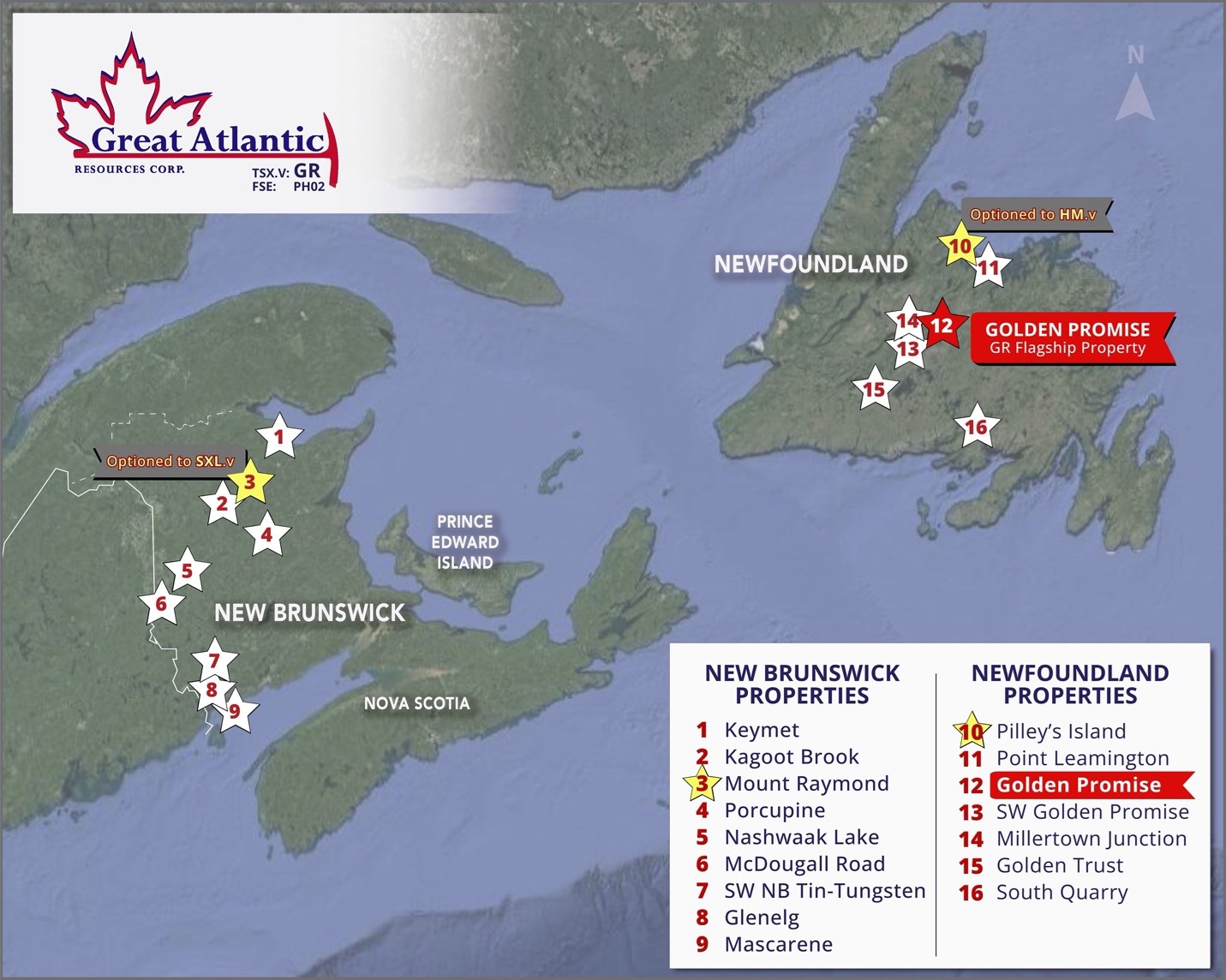
To view an enhanced version of this graphic, please visit:
https://images.newsfilecorp.com/files/3027/310064_1c9cf51954283b7a_005full.jpg
This press release includes certain statements that may be deemed "forward-looking statements". All statements in this release, other than statements of historical facts, that address future exploration drilling, exploration activities and events or developments that the Company expects, are forward looking statements. Although the Company believes the expectations expressed in such forward-looking statements are based on reasonable assumptions, such statements are not guarantees of future performance and actual results or developments may differ materially from those in forward-looking statements. Factors that could cause actual results to differ materially from those in forward-looking statements include exploitation and exploration successes, continued availability of financing, and general economic, market or business conditions.
Neither TSX Venture Exchange nor its Regulation Services Provider (as that term is defined in the policies of the TSX Venture Exchange) accepts responsibility for the adequacy or accuracy of this release.
Great Atlantic Resources Corp.
888 Dunsmuir Street - Suite 888, Vancouver, B.C., V6C 3K4
To view the source version of this press release, please visit https://www.newsfilecorp.com/release/310064
FAQ
AI-generated questions and answers. How Rhea-AI works. Not financial advice.