Silver Hammer Prepares for Drill Program at Its 100% Owned California Patented Claim at The Eliza Project in Nevada
Rhea-AI Summary
Silver Hammer Mining (OTC:HAMRF) is preparing a Phase 1 drill program on its 100% owned California Patented Claim at the Eliza Silver Project, White Pine County, Nevada.
Up to 15 holes (~1,500 metres) will test five priority targets defined by historical mapping, soil sampling, heliborne geophysics and high-grade rock samples (including a 1,290 g/t Ag sample).
AI-generated analysis. Not financial advice.
Positive
- Phase 1 drill program planned: up to 15 holes (~1,500 metres)
- Patented land (California Patent) allows drilling without exploration permits
- Five priority targets identified from mapping, soil surveys, geophysics and historic workings
- High-grade rock sample reported: 1,290 g/t Ag (sample PN662703)
Negative
- Phase 2 program on greater Eliza claims is pending US Forest Service approval
- Phase 1 scale (~1,500 metres) is limited and may not fully delineate the system
News Market Reaction – HAMRF
On the day this news was published, HAMRF declined 2.50%, reflecting a moderate negative market reaction.
Data tracked by StockTitan Argus on the day of publication.
Vancouver, British Columbia--(Newsfile Corp. - March 11, 2026) - Silver Hammer Mining Corp. (CSE: HAMR) (the "Company" or "Silver Hammer") is pleased to announce that the Company is finalizing plans for its Phase 1 drill program on its
"We are looking forward to Phase 1 of drill-testing priority targets at the
New priority drill targets on the California Patent have been identified from historical geological data from past exploration programs including surface mapping and sampling, an extensive soil sampling program, heliborne geophysics (magnetics and radiometrics), and from historical records of old mine workings. Up to five structures appear to be mineralized with silver and/or gold, and these form the five distinct drill targets (refer to Fig. 1).
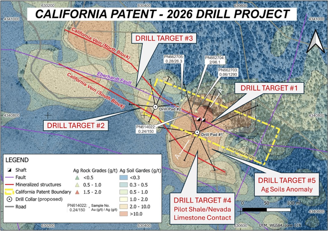
Fig. 1 - California Patent Drill Targets Map with a Compilation of Geological Structures, Rock and Soil Samples
To view an enhanced version of this graphic, please visit:
https://images.newsfilecorp.com/files/9597/288112_ffcef8640486490b_001full.jpg
Up to a fifteen (15) hole drill program, consisting of approximately 1,500 metres (5,000 feet), has been designed to test following targets:
- Drill Target #1: The California Vein dips steeply, at approximately 80O to the northeast and is proximal to the Eberhardt Fault at surface. Mineralization has been found in a set of rock samples taken in 2021 and 2022 on or in the vicinity of the California Vein and the Eberhardt Fault, with four of the eight samples showing significant silver and/or gold grades (see Table 1 - please refer to the Company's news releases dated December 6, 2021 and May 11, 2022 for more information). Airborne magnetics (vertical gradient) and radiometrics (total count) both show low anomalies as distinctly linear features at the Eberhardt Fault/California Vein zone. Two drill pads would allow for drilling the California Vein from the south, over a distance exceeding 150 metres along strike with a set of six fanned holes.
Table 1 - Rock Samples at California Patent (Mapping and Sampling Programs, 2021-2022)
| Sample No. | Au (g/t) | Ag (g/t) | As (ppm) | Cd (ppm) | Cu (ppm) | Mn (ppm) | Mo (ppm) | Pb (ppm) | Sb (ppm) | Zn (ppm) |
| PN662702 | 0.01 | 0.524 | 14.6 | 1 | 2 | 541 | 2 | 9.05 | 5 | 10.8 |
| PN662703 | 0.06 | 1290 | 33.8 | 14 | 56.8 | 2750 | 5.6 | 619 | 268 | 71.1 |
| PN662704 | 2.00 | 96.1 | 19 | 12 | 32 | 1620 | 2.42 | 179 | 33.2 | 128 |
| PN662705 | 0.28 | 26.3 | 10.5 | 1 | 13.6 | 316 | 2.12 | 39.2 | 11.5 | 21.3 |
| PN662706 | 0.01 | 2.44 | 25.3 | 1 | 7.05 | 4610 | 5.15 | 9.1 | 7.88 | 31.6 |
| PN662707 | 0.01 | 14.1 | 19.4 | 1 | 7.08 | 2020 | 2 | 9.9 | 10.1 | 22 |
| PN662708 | 0.01 | 0.275 | 8.28 | 1 | 3.58 | 96.8 | 2 | 18.5 | 5 | 7.68 |
| PN614022 | 0.24 | 150 | 32.2 | 14.8 | 84.5 | 1340 | 2.35 | 324 | 51.3 | 172 |
- Drill Target #2: The California Vein has been interpreted to have been cut by the Eberhardt Fault just above the current topographic surface and down-dropped and displaced southwards in the South Block of the Eberhardt Fault (refer to Fig. 2). Silver mineralization in the geochemical soil anomaly and rock sampling suggests this repetition of the California Vein daylights approximately 70 metres to the south of the surface trace of the Eberhardt Fault (and the outcropping of the California Vein in the North Block of the fault). Six fanned holes, drilled southwards from the two drill pads, are designed to test this fault-displaced portion of the California Vein.
- Drill Target #3: The Eberhard Fault is expected to be intersected by the set of six northwards-trending drill holes. This drill-testing is expected to provide additional information of which structure is the source of the mineralized rock and soil samples that are in proximity of both the California Vein and the Eberhardt Fault.
- Drill Target #4: Pilot Shale has been mapped at surface in the South Block of the normal-type Eberhardt Fault. Geological interpretation of the stratigraphy leads to an expectation of the Pilot Shale and the stratigraphically lower Nevada Limestone contact to be located approximately 60 metres below the topographic surface in the South Block of the Eberhardt Fault. This brecciated lithologic contact has been recognized as a potential trap for hydrothermal fluids during the mineralization stage. Such association of manto-style mineralization and basal brecciation at nearby Treasure Hill is described by R.M. Smith1: 'The chloride ore bodies were localized in the uppermost strata of the gently west-dipping Guilmette (Nevada) Limestone just below the Pilot Shale, most of which is eroded from all but the Telegraph Peak portion of Treasure Hill. The limestone is brecciated by premineralization bedding faults, the most prominent of which is along its contact with the shale'. During past mining in the late 1800s, several exploratory drifts were driven in the California Mine, with a goal to reach this Pilot Shale - Nevada Limestone contact. The two vertical holes from the two drill pads are designed to explore for such potential manto-type mineralization at the lithologic contact (refer to Fig. 2).
1 R.K. Hose, M.C. Blake and R.M. Smith, Bulletin 85, Geology and Mineral resources of White Pine County, Nevada, Nevada Bureau of Mines and Geology Part II, Mineral Resources, 1976.
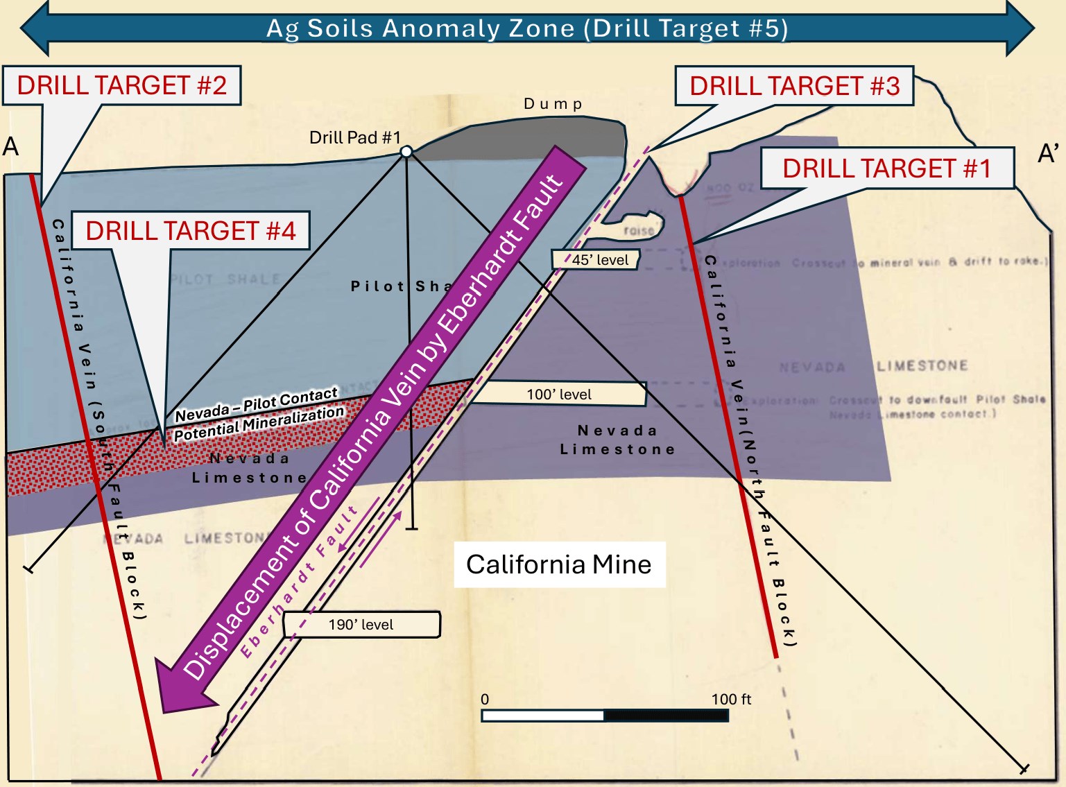
Fig. 2 - California Mine Section A-A', with Drill Targets and Historic Underground Workings
To view an enhanced version of this graphic, please visit:
https://images.newsfilecorp.com/files/9597/288112_ffcef8640486490b_002full.jpg
- Drill Target #5: The broad zone of anomalous silver values follows the trend of the high rock samples as well as the trend of magnetic and radiometric anomalies. This zone measures up to 200 metres wide north-south and over 400 metres east-west. All holes are within this soil geochemical anomaly.
Mr. Ball added, "The intersection of high angle structures in several orientations and the potential of the low-angle shale-limestone contact at the location of a historic mine, combined with several high-grade rock samples, forms a number of exciting and compelling drill targets."
Qualified Person
The scientific and technical aspects of this press release have been reviewed and approved under the supervision of Damir Cukor, P.Geo. Mr. Cukor is a Qualified Person (QP) under National Instrument 43-101 Standards of Disclosure for Mineral Projects and as a consultant for the Company as Technical Director – Projects.
About Silver Hammer Mining Corp.
Silver Hammer Mining Corp. is a well-funded junior resource company focused on advancing past- producing high-grade silver projects in the United States. Silver Hammer controls
On Behalf of the Board of Silver Hammer Mining Corp.
Peter A. Ball
President & CEO, Director
E: peter@silverhammermining.com
For investor relations inquiries, contact:
Peter A. Ball
President & CEO
778.344.4653
E: investors@silverhammermining.com
Forward-Looking Information
This press release contains "forward-looking information" within the meaning of applicable Canadian securities legislation. Forward-looking information in this press release includes, without limitation, statements relating to the Offering, the intended use of proceeds from the Offering, and other statements which are subject to a number of conditions, as described elsewhere in this news release. These statements are based upon assumptions that are subject to significant risks and uncertainties, including risks regarding the mining industry, commodity prices, market conditions, general economic factors, management's ability to manage and to operate the business, and explore and develop the projects of the Company, and the equity markets generally. Because of these risks and uncertainties and as a result of a variety of factors, the actual results, expectations, achievements or performance of the Company may differ materially from those anticipated and indicated by these forward-looking statements. Any number of factors could cause actual results to differ materially from these forward-looking statements as well as future results. Although the Company believes that the expectations reflected in forward-looking statements are reasonable, they can give no assurances that the expectations of any forward-looking statements will prove to be correct. Except as required by law, the Company disclaims any intention and assume no obligation to update or revise any forward-looking statements to reflect actual results, whether as a result of new information, future events, changes in assumptions, changes in factors affecting such forward-looking statements or otherwise. This news release does not constitute an offer to sell or a solicitation of an offer to sell any of securities in the United States. The securities have not been and will not be registered under the U.S. Securities Act or any state securities laws and may not be offered or sold within the United States or to U.S. Persons unless registered under the U.S. Securities Act and applicable state securities laws or an exemption from such registration is available.
The Canadian Securities Exchange does not accept responsibility for the adequacy or accuracy of this release. The Canadian Securities Exchange has neither approved nor disapproved the contents of this press release.
![]()
To view the source version of this press release, please visit https://www.newsfilecorp.com/release/288112