Intrepid Metals Outlines New Clanton Zone with 2.19% Copper over 24.35m within 0.80% Copper over 71.70m at Corral Copper
Rhea-AI Summary
Intrepid Metals (OTCQB: IMTCF) has announced significant drilling results from its new Clanton Zone at the Corral Copper Property in Arizona. The highlight intersection from hole CC25_040 revealed 0.88% Copper Equivalent over 71.70m, including 2.30% CuEq over 24.35m and an impressive 5.32% CuEq over 7.90m.
The newly discovered Clanton Zone, located 200m south of the Ringo Zone, has been traced over 180m and features carbonate replacement deposit (CRD) style copper-gold-silver mineralization. The zone is defined by three holes and is separated from the Ringo Zone by the West Star Hill Fault. The company has completed its 2025 drill program at Corral with twenty-one drill holes totaling 5,765.4 meters across multiple zones, with results pending for six holes.
Positive
- Discovery of new Clanton Zone with high-grade copper mineralization (2.19% Cu over 24.35m)
- Significant intersection in CC25_040 showing 0.88% CuEq over 71.70m
- Mineralization traced over 180m, indicating potential for expansion
- Successful completion of 21-hole drill program across multiple zones
Negative
- Results for six drill holes still pending
- Zone is separated by fault, which could affect continuity
News Market Reaction – IMTCF
In the Oct 2 session, IMTCF declined 6.54%, reflecting a notable negative market reaction.
Data tracked by StockTitan Argus on the day of publication.
AI-generated analysis. How Rhea-AI works. Not financial advice.
Vancouver, British Columbia--(Newsfile Corp. - October 2, 2025) - Intrepid Metals Corp. (TSXV: INTR) (OTCQB: IMTCF) ("Intrepid" or the "Company") is pleased to provide assay results from the new Clanton Zone at the Company's Flagship Corral Copper Property ("Corral" or the "Property") in Cochise County, Arizona. The Company has completed its 2025 drill program at Corral, with a total of twenty-one drill holes (5765.4 meters ("m")) across the Clanton, Ringo, Earp, and Holliday zones. Assay results for the final six drill holes are still pending.
The Clanton Zone is located roughly 200m south of the Ringo Zone and has been traced over 180m (see Figure 1 below). This new zone consists of carbonate replacement deposit ("CRD") style copper-gold-silver mineralization similar to Ringo but separated by the West Star Hill Fault. The latest drill hole, CC25_040 intersected 71.70m of
"The latest results from Corral continue to build on the momentum we've established, confirming the strength of the system and its potential to support long-term growth," said Mark Morabito, Chairman and CEO of Intrepid Metals. "The discovery of a new zone south of Ringo is particularly exciting, as it expands our exploration footprint and unlocks further opportunities to create shareholder value. Together, these advances underscore the significant upside that remains across the property."
Highlights from Hole CC25_040:
CC25_0402:
- 71.70m of
0.80% Copper ("Cu"), 0.10 grams per ton ("gpt") Gold ("Au") and 5.35 gpt Silver ("Ag") (0.88% Copper Equivalent ("CuEq")1) including,- 24.35m of
2.19% Cu, 0.17 gpt Au and 11.59 gpt Ag (2.30% CuEq1) including - 7.90m of
5.54% Cu, 0.24 gpt Au and 16.19 gpt Ag (5.32% CuEq1).
- 24.35m of
- 26.40m of
0.07% Cu, 0.06 gpt Au and 3.27 gpt Ag (0.18% CuEq1). - 77.55m of
0.11% Cu, 0.06 gpt Au and 2.21 gpt Ag (0.15% CuEq1).
New Zone at Corral Copper
The emerging Clanton Zone is defined by 3 holes including CC24-16, CC_24_17, and CC25_40. The Clanton Zone is separated from the Ringo Zone by the northwest trending West Star Hill Fault and is a shallowly east-dipping open-ended lens of CRD mineralization that is continuous for at least 180 meters that is between 25 and 30 meters thick. Historic drilling in the area was used to guide exploration drilling south of the West Star Hill Fault.
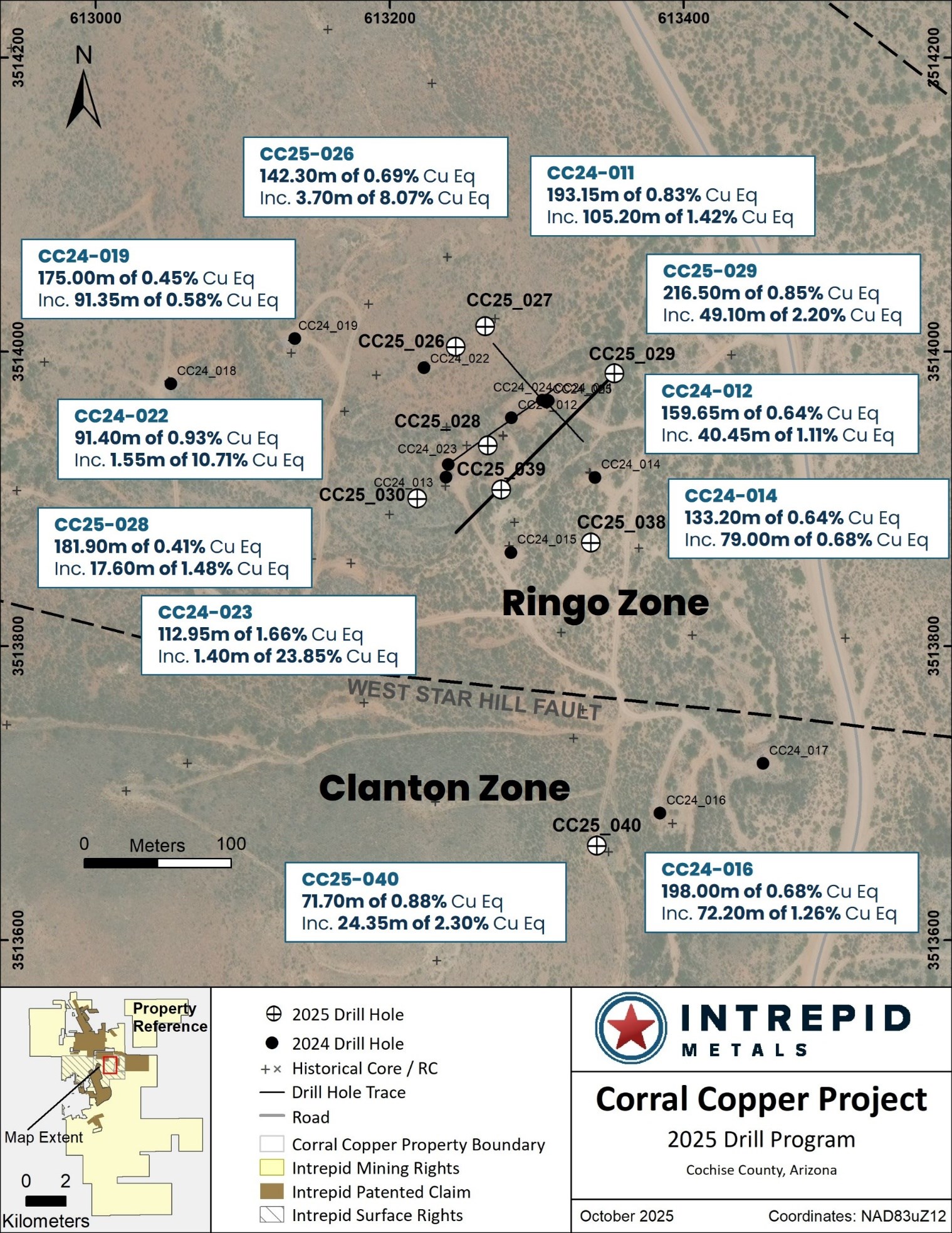
Figure 1: Drill plan map from the Ringo and Clanton Zones at Corral Copper
To view an enhanced version of this graphic, please visit:
https://images.newsfilecorp.com/files/6187/268808_81435f4774e858fe_001full.jpg
Technical Information
All scientific and technical information in this news release has been reviewed and approved by Daniel MacNeil, P.Geo. Mr. MacNeil is a Technical Advisor to the Company and is a qualified person for the purposes of National Instrument 43-101 - Standards of Disclosure for Mineral Projects.
Mr. MacNeil has verified the drilling data disclosed in this news release, including the assay and test data underlying the information or opinions contained in this news release. Mr. MacNeil verified the data disclosed (including previously released Intrepid data underlying the information disclosed) in this news release by reviewing imported and sorted assay data; checking the performance of blank samples and certified reference materials; reviewing the variance in field duplicate results; and reviewing grade calculation formulas. Mr. MacNeil detected no significant QA/QC issues during review of the data and is not aware of any sampling, recovery or other factors that could materially affect the accuracy or reliability of the drilling data referred to in this news release.
As it relates to adjacent properties disclosed in this news release, Mr. MacNeil has been unable to verify the information and that the information is not necessarily indicative to the mineralization on the Corral Copper Property.
Table 1: Drill Intercepts for the Ringo Zone1
| CC25_0402 COMPOSITE INTERCEPTS | |||||||||
| DRILL HOLE DETAILS | ANALYZED GRADE | DILUTED METAL EQUIVALENT1 | |||||||
| DRILL HOLE | FROM | TO | LENGTH | COPPER | GOLD | SILVER | ZINC | CUEQ | AUEQ |
| ID | (m) | (m) | (m) | (%) | (ppm) | (ppm) | (%) | (%) | (ppm) |
| CC25_40 | 19.90 | 21.50 | 1.60 | 0.01 | 0.14 | 3.20 | 0.00 | 0.11 | 0.15 |
| CC25_40 | 33.60 | 36.55 | 2.95 | 0.01 | 0.14 | 0.70 | 0.00 | 0.09 | 0.13 |
| CC25_40 | 39.30 | 42.95 | 3.65 | 0.01 | 0.14 | 1.28 | 0.00 | 0.10 | 0.14 |
| CC25_40 | 47.20 | 118.90 | 71.70 | 0.80 | 0.10 | 5.35 | 0.46 | 0.88 | 1.21 |
| Incl. | 81.40 | 105.75 | 24.35 | 2.19 | 0.17 | 11.59 | 1.05 | 2.30 | 3.15 |
| And | 83.45 | 91.35 | 7.90 | 5.54 | 0.24 | 16.19 | 1.50 | 5.32 | 7.30 |
| And | 94.80 | 105.75 | 10.95 | 0.73 | 0.14 | 10.99 | 1.16 | 1.06 | 1.45 |
| CC25_40 | 127.50 | 129.00 | 1.50 | 0.02 | 0.03 | 1.80 | 0.17 | 0.09 | 0.12 |
| CC25_40 | 135.00 | 136.50 | 1.50 | 0.01 | 0.02 | 0.25 | 0.26 | 0.08 | 0.12 |
| CC25_40 | 144.70 | 149.25 | 4.55 | 0.04 | 0.03 | 1.98 | 0.36 | 0.15 | 0.21 |
| CC25_40 | 157.60 | 184.00 | 26.40 | 0.07 | 0.06 | 3.27 | 0.28 | 0.18 | 0.25 |
| Incl. | 175.40 | 184.00 | 8.60 | 0.13 | 0.10 | 2.00 | 0.25 | 0.24 | 0.33 |
| CC25_40 | 194.75 | 196.00 | 1.25 | 0.04 | 0.02 | 2.10 | 0.20 | 0.11 | 0.15 |
| CC25_40 | 199.00 | 201.60 | 2.60 | 0.04 | 0.04 | 1.55 | 0.08 | 0.09 | 0.12 |
| CC25_40 | 238.00 | 315.55 | 77.55 | 0.11 | 0.06 | 2.21 | 0.05 | 0.15 | 0.21 |
| Incl. | 255.00 | 267.00 | 12.00 | 0.19 | 0.10 | 2.86 | 0.07 | 0.26 | 0.35 |
Table 2: Drill Hole Location Information for Holes CC25-026 through CC25_046
| DRILL HOLE | START DATE | END DATE | EASTING (m) | NORTHING (m) | ELEVATION (m) | AZIMUTH (°) | INCLINATION (°) | DEPTH (m) |
| CC25_026 | 2025-04-28 | 2025-05-03 | 613245 | 3514003 | 1424 | 0 | -90 | 234.4 |
| CC25_027 | 2025-05-04 | 2025-05-08 | 613265 | 3514017 | 1423 | 0 | -90 | 224.65 |
| CC25_028 | 2025-05-09 | 2025-05-16 | 613267 | 3513936 | 1420 | 0 | -90 | 240.8 |
| CC25_029 | 2025-05-17 | 2025-05-23 | 613353 | 3513985 | 1415 | 225 | -60 | 305.1 |
| CC25_030 | 2025-05-24 | 2025-05-30 | 613219 | 3513900 | 1423 | 0 | -90 | 270.7 |
| CC25_031 | 2025-05-31 | 2025-06-06 | 611891 | 3515918 | 1501 | 235 | -40 | 320.65 |
| CC25_032 | 2025-06-07 | 2025-06-12 | 612028 | 3515934 | 1472 | 0 | -90 | 313.05 |
| CC25_033 | 2025-06-12 | 2025-06-17 | 612135 | 3515757 | 1485 | 235 | -80 | 230.1 |
| CC25_034 | 2025-06-18 | 2025-06-22 | 612169 | 3514840 | 1495 | 250 | -45 | 204.2 |
| CC25_035 | 2025-06-22 | 2025-06-29 | 612258 | 3514776 | 1494 | 245 | -50 | 249.95 |
| CC25_036 | 2025-06-30 | 2025-07-06 | 612177 | 3514898 | 1497 | 250 | -50 | 219.6 |
| CC25_037 | 2025-07-07 | 2025-07-18 | 613050 | 3514029 | 1435 | 0 | -90 | 334.65 |
| CC25_038 | 2025-07-19 | 2025-07-29 | 613337 | 3513870 | 1422 | 0 | -90 | 282.55 |
| CC25_039 | 2025-07-30 | 2025-08-09 | 613276 | 3513906 | 1420 | 0 | -90 | 255.75 |
| CC25_040 | 2025-08-10 | 2025-08-22 | 613341 | 3513664 | 1438 | 0 | -90 | 331.30 |
| CC25_041 | 2025-08-23 | 2025-08-27 | 613099 | 3513981 | 1428 | 0 | -90 | 310.00 |
| CC25_042 | 2025-08-28 | 2025-09-02 | 613188 | 3513970 | 1425 | 0 | -90 | 274.90 |
| CC25_043 | 2025-09-03 | 2025-09-10 | 613305 | 3514040 | 1420 | 0 | -90 | 212.15 |
| CC25_044 | 2025-09-11 | 2025-09-15 | 613156 | 3513936 | 1425 | 0 | -90 | 290.15 |
| CC25_045 | 2025-09-15 | 2025-09-22 | 614067 | 3513972 | 1411 | 215 | -70 | 391.05 |
| CC25_046 | 2025-09-23 | 2025-09-27 | 613206 | 3513935 | 1423 | 0 | -90 | 269.75 |
Quality Assurance and Quality Control
Drill core was first reviewed by a geologist, who identified and marked intervals for sampling. The marked sample intervals were then cut in half with a diamond saw; half of the core was left in the core box and the other half was removed, placed in plastic bags, sealed and labeled. Intervals and unique sample numbers are recorded on the drill logs and the samples are sequenced with standards and blanks inserted according to a predefined QA/QC procedure. The samples are maintained under security on site until they are shipped to the analytical lab.
All core samples were sent to ALS Geochemistry (ALS), a division of ALS Global, in Tucson, Arizona, for sample preparation, with pulps sent to the ALS Geochemistry laboratory in Reno, Nevada for analysis. ALS meets all requirements of International Standards ISO/IEC 17025:2017 and ISO 9001:2015 for analytical procedures and is independent of the Company. HQ size core was split and sampled over approximately two metre intervals. Samples were analyzed using: ALS's Fire Assay Fusion method (Au-AA23) with an AA finish for gold and by gravimetric finish (Au-GRA21) for samples assaying greater than 10 ppm (gpt) gold; by a 36-element four acid digest ICP-AES analysis (ME-ICP61) with additional analysis for High Grade Cu (Cu-OG62), High Grade Zn (Zn-OG62) and High Grade Pb (Pb-OG62); and for silver assays above 100 ppm (g/t) by Fire Assay Fusion method with gravimetric finish (Ag-GRA21). ME-ICP61 results were reported in parts per million (ppm), High Grade (OG62) results were reported in percent (%). In addition to ALS quality assurance- quality control (QA/QC) protocols, Intrepid implements an internal QA/QC program that includes the insertion of sample blanks, duplicates, and standards, with QA QC control samples comprising approximately
About Corral Copper
The Corral Copper Property, located near historical mining areas, is an advanced exploration and development opportunity in Cochise County, Arizona. Corral is located 15 miles east of the famous mining town of Tombstone and 22 miles north of the historic Bisbee mining camp which has produced more than 8 billion pounds of copper3. Production from the Bisbee mining camp, or within the district as disclosed in the next paragraph, is not necessarily indicative of the mineral potential at Corral.
The district has a mining history dating back to the late 1800s, with several small mines extracting copper from the area in the early 1900s, producing several thousand tons. Between 1950 and 2008, various companies explored parts of the district, but the effort was uncoordinated, non-synergistic and focused on discrete land positions and commodities due to the fragmented ownership. There is over 50,000m of historical drilling at Corral mainly centered on the Ringo, Earp and Holliday Zones and although this core has been destroyed, Intrepid has a historical digital drill hole archive database which the Company uses for the purposes of exploration targeting and drill hole planning. Intrepid, through ongoing exploration drilling and surface geological mapping, sampling and prospecting is increasing confidence in the validity of this data.
Intrepid is confident that by combining modern exploration techniques with historical data and with a clear focus on responsible development, the Corral Copper Property can quickly become an advanced exploration stage project and move towards development studies.
About Intrepid Metals Corp.
Intrepid Metals Corp. is a Canadian company focused on exploring for high-grade essential metals such as copper, silver, and zinc mineral projects in proximity to established mining jurisdictions in southeastern Arizona, USA. The Company has acquired or has agreements to acquire several drill ready projects, including the Corral Copper Project (a district scale advanced exploration and development opportunity with significant shallow historical drill results), the Tombstone South Project (within the historical Tombstone mining district with geological similarities to the Taylor Deposit, which was purchased for
INTREPID METALS CORP.
On behalf of the Company
"Mark Morabito"
Chairman & CEO
For further information regarding this news release, please contact:
Mark Morabito, Chairman & CEO
604-681-8030
info@intrepidmetals.com
Notes
1 Composite intervals are calculated using length weighted averages based on a combination of lithological breaks and copper, gold, silver and zinc assay values according to a
2 Drill hole CC25_040 contained two intervals where samples could not be obtained due to loss of recovery during drilling. These intervals occur from 93.55-94.80 (1.25m) and 96.60-99.65m (3.05m). These intervals are located in a mineralized core run and have been included in composite calculations but have been assigned zero assay values for copper, gold, silver and zinc for purposes of weighted average composite intercept calculations.
3 Information disclosed in this news release regarding the historic Bisbee Camp can be found on the Copper Queen Mine website, on the City of Bisbee website (www.bisbeeaz.gov/2174/Bisbee-History) and from Briggs, D.F., 2015, History of the Warren (Bisbee) Mining District, Arizona Geological Survey Contributed Report CR-15-b, 8 p.
4 Details regarding the sale of the Taylor Deposit can be found in South32 News Release dated October 8, 2018 (South32 completes acquisition of Arizona Mining).
Cautionary Note Regarding Forward-Looking Information
Certain statements contained in this release constitute forward-looking information within the meaning of applicable Canadian securities laws. Such forward-looking statements relate to: the potential of the property; the interpretation of drills results; the potential to support long-term growth; unlocking further opportunities to create shareholder value; the significant upside that remains across the property; the exploration potential of the Corral Copper Property and the Company's other mineral projects; and potential future production.
In certain cases, forward-looking information can be identified by the use of words such as "plans", "expects", "budget", "scheduled", "estimates", "forecasts", "intends", "anticipates" or "believes", or variations of such words and phrases or state that certain actions, events or results "may", "could", "would", "might", "occur" or "be achieved" suggesting future outcomes, or other expectations, beliefs, plans, objectives, assumptions, intentions or statements about future events or performance. Forward-looking information contained in this news release is based on certain factors and assumptions regarding, among other things, the Company can raise additional financing to continue operations; the results of exploration activities, commodity prices, the timing and amount of future exploration and development expenditures, the availability of labour and materials, receipt of and compliance with necessary regulatory approvals and permits, the estimation of insurance coverage, and assumptions with respect to currency fluctuations, environmental risks, title disputes or claims, and other similar matters. While the Company considers these assumptions to be reasonable based on information currently available to it, they may prove to be incorrect.
Forward looking information involves known and unknown risks, uncertainties and other factors which may cause the actual results, performance or achievements of the Company to be materially different from any future results, performance or achievements expressed or implied by the forward-looking information. Such factors include risks inherent in the exploration and development of mineral deposits, including risks relating to the ability to access infrastructure, risks relating to the failure to access financing, risks relating to changes in commodity prices, risk related to unanticipated geological or structural formations and characteristics risks related to current global financial conditions, risks related to current global financial conditions and the impact of any future global pandemic on the Company's business, reliance on key personnel, operational risks inherent in the conduct of exploration and development activities, including the risk of accidents, labour disputes and cave-ins, regulatory risks including the risk that permits may not be obtained in a timely fashion or at all, financing, capitalization and liquidity risks, risks related to disputes concerning property titles and interests, environmental risks and the additional risks identified in the "Risk Factors" section of the Company's reports and filings with applicable Canadian securities regulators.
Although the Company has attempted to identify important factors that could cause actual actions, events or results to differ materially from those described in forward-looking information, there may be other factors that cause actions, events or results not to be as anticipated, estimated or intended. Accordingly, readers should not place undue reliance on forward-looking information. The forward-looking information is made as of the date of this news release. Except as required by applicable securities laws, the Company does not undertake any obligation to publicly update or revise any forward-looking information.
Neither the TSX Venture Exchange nor its Regulation Services Provider (as that term is defined in the policies of the TSX Venture Exchange) has reviewed or accepts responsibility for the adequacy or accuracy of this release.
![]()
To view the source version of this press release, please visit https://www.newsfilecorp.com/release/268808