Kyocera and Nagasaki University Develop “Energy Harvesting Smart Buoy” to Collect Ocean Data
New innovation combines
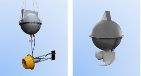
Energy Harvesting Smart Buoys. Left: SLTT (Small Lens-type Tidal Turbines), Right: VTT (Vertical-axis Tidal Turbines) (Graphic: Business Wire)
Development Background
Marine pollution and climate change have become serious societal issues. To solve these issues and help create a more sustainable world, scientists need more reliable ways to monitor and visualize various sea conditions. However, maintaining a stable power supply is a big challenge for continuous data collection at sea. Therefore,
Outline of the Prototypes
A buoy equipped with a tidal-current power generation system supplies power to the Kyocera GPS multi-unit and connected sensors *1. The GPS multi-unit is a compact Kyocera IoT device, equipped with various sensors and antennas, compatible with GPS, GLONASS, and Michibiki *2 location tracking systems.
*1 Equipped with a general-purpose serial interface (RS-485), it can connect sensors according to application.
*2 GLONASS is a positioning system using Russian satellites. Michibiki is a Japanese satellite positioning system consisting mainly of quasi-zenith orbiting satellites.
Each prototype is equipped with two different tidal-current power generation systems:
SLTT (Small Lens-type Tidal Turbines) - The buoy and power generation are separate, and a diffuser is installed around the turbine. In addition to protecting the turbine, the diffuser has the effect of increasing the flow of water for better power generation.
VTT (Vertical-axis Tidal Turbines) - The power generation element is directly connected to the buoy. Its AI-guided design incorporates a tilted axis to optimize turbine rotation amid heavy ocean swells and waves.
|
SLTT |
VTT |
Size |
Total: Approx. 1800mm Buoy: 520mm ×500mm Generator: 400mm ×507mm |
Total: Approx. 910mm Buoy: 520mm×500mm Generator: 400mm×200mm |
Weight |
Approx. 32kg |
Approx. 31kg |
Battery |
Tidal power generation + Secondary battery (54,000mA) |
|
External sensor |
Current meter (Velocity, direction of flow, and water temperature) |
|
Internal sensor |
Temperature and Humidity/Acceleration/Charging current/Battery voltage/Leakage detection |
|
Location information |
GPS / GLONASS / Michibiki*2 |
|
Antenna |
Built-in |
|
Communication method |
LTE* Cat.M1 (LTE-M) |
|
Compatible band |
B1/B8/B19/B26 |
|
SIM |
nano SIM |
|
Role of
Organization |
Role |
|
Turbine design optimized for tidal-current power generation |
Kyocera |
Development of various sensor controls, power control, buoy design, cloud applications, and mobile applications |
* PAL Co., Ltd., and
Future Initiatives
To promote ongoing ocean monitoring, the companies are planning to support a water temperature-salinity sensor (temperature, salinity, and electrical conductivity), chlorophyll turbidity sensor (chlorophyll, turbidity, and water temperature), DO sensor (dissolved oxygen and water temperature), and an underwater camera. Performance and operation will be improved, along with a reduction in size and weight, in commercial versions. Kyocera will also build an IoT platform to store collected data, and ongoing testing will be conducted mainly in
Please see the details in the link below,
https://global.kyocera.com/news/2021/0801_kswa.html
*LTE is a trademark of ETSI.
View source version on businesswire.com: https://www.businesswire.com/news/home/20210825005240/en/
Corporate Communications
TEL: Head Office +81-(0)75-604-3416 / E-mail: webmaster.pressgl@kyocera.jp
Source: