Max Resource Conducts LiDAR Survey over the Entire Mora Gold Property
Rhea-AI Summary
Max Resource (OTC: MXROF) will conduct a high-resolution airborne LiDAR survey across the entire 700 ha Mora mining concession KK6-08031 to help delineate drill targets (BQ, BX, NAN) and map hidden artisanal workings.
Max holds exclusive rights to acquire 100% of the concession and has paid USD $250,000 in option payments to date. Highlight channel samples include 45.0 g/t Au & 7,110 g/t Ag over 1.0m. The Company also reported a USD $4.8m fully funded 2025 Freeport earn-in program on Sierra Azul.
Positive
- LiDAR survey across 700 ha Mora concession
- Channel sample: 45.0 g/t Au & 7,110 g/t Ag over 1.0m
- Confirmed option payments of USD $250,000
- Fully funded USD $4.8m 2025 Freeport earn-in program
Negative
- Debt settlement issues 500,000 shares at $0.12 (subject to TSXV approval)
- Granted 11,500,000 PSUs to consultants (vesting one year)
- Mora Property remains undrilled as of November 21, 2025
News Market Reaction – MXROF
In the trading session that priced this news, MXROF gained 5.71%, reflecting a notable positive market reaction.
Data tracked by StockTitan Argus on the day of publication.
AI-generated analysis. How Rhea-AI works. Not financial advice.
Vancouver, British Columbia--(Newsfile Corp. - November 21, 2025) - MAX RESOURCE CORP. (TSXV: MAX) (OTC Pink: MXROF) (FSE: M1D2) ("Max" or the "Company") is pleased to report that Max will be conducting an airborne high-resolution LiDAR survey over the entire 700ha Mora mining concession KK6-08031, located within the productive Middle Cauca Gold Belt host to several world class gold deposits, 85-km south of Medellin, Colombia, which the Company has the exclusive right to purchase
Highlights
- The LiDAR survey forms part of the initial steps to delineate high priority drill locations within the BQ, BX, NAN targets and identify new targets.
- To date, 33 artisanal underground mines are noted in historic technical reports of which Max has successfully mapped 9 inactive mines. The depth or advance of the artisanal mines varies between 5.0m and 90.5m. LiDAR can identify hidden artisanal mines/works due to tree and plant cover.
- Channel sampling artisanal underground mines is very important, it's almost like having a drillhole, identifying geological characteristics of fresh rock such as lithology, hydrothermal alterations, types of sulfides or mineralization, structures-uplifts-faults-veins and veinlets.
- LiDAR will assist in building an accurate 3D model, the key to maximizing the success of Max's planned drill program, being the first known drilling event on mining concession KK6-08031.
"The LiDAR datasets will be used to delineate drill design on the BX, BQ and NAN targets, providing unprecedented ground details to be observed for the first time," says Max Head Geologist Sergio Cocunubo.
"Sampling of artisanal mines and workings were significant steps conducted at Collective Mining's Guayabales and Continental Gold's Buritica in which we identified geological characteristics and confirmed active galleries in gold and silver production," he concluded.
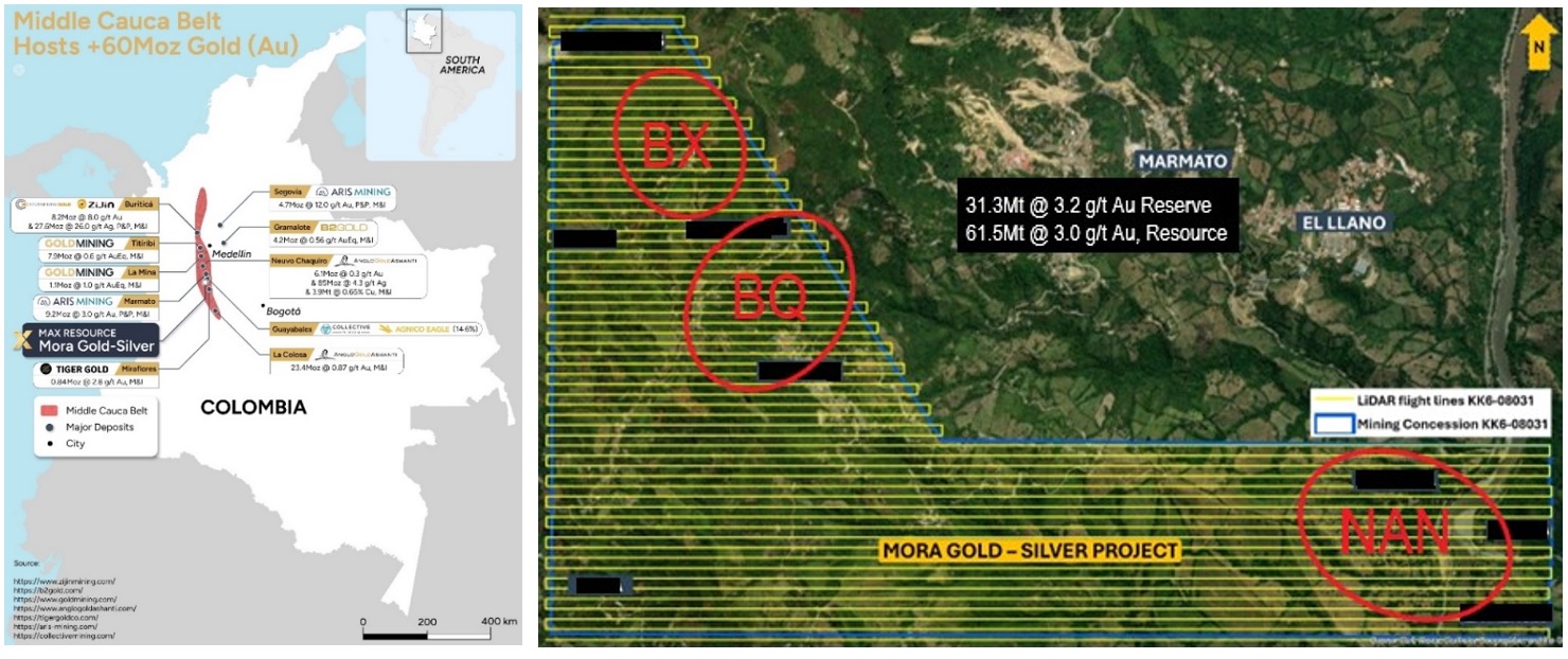
Figure 1. The LiDAR survey will consist of GSD (ground sampling space) between 2 and 7 cm. Longitudinal overlap
To view an enhanced version of this graphic, please visit:
https://images.newsfilecorp.com/files/3834/275412_max%20figure%201.jpg
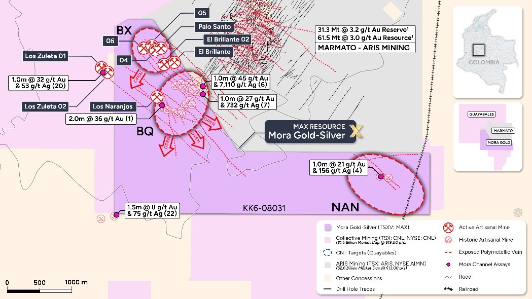
Figure 2. Mora Property encompasses over 40 historic workings, 5 active mines, a series of exposed polymetallic structures over 2,500m by 1,000m.
To view an enhanced version of this graphic, please visit:
https://images.newsfilecorp.com/files/3834/275412_078ff38bb4c7dbeb_003full.jpg
Surface samples collected from San Juan and NAN by their nature are selective samples and may not be indicative of underlying mineralization.
What is LiDAR?
LiDAR is a relatively new technology whereby surface geomorphology patterns and outcrop patterns suggestive of underlying geology and structure can be identified including subtle aspects and seeing through the surface trees and plant cover that can hide surface details.
LiDAR is a modern remote sensing technique that concurrently takes high-resolution (hi-res) images and builds a detailed digital terrain model (DTM) and detailed digital surface model (DSM) utilizing an extremely sensitive and accurate digital mapping tool. Together, the DTM and Hi-Resolution images provide three-dimensional (3D) model of the terrain, where additional data (geophysics, drilling, surface sampling, etc.) can be incorporated to provide a multi-dimensional model from which multiple data sources can be interpreted accurately, all in 3D high-accuracy system with more precise, efficient, and reliable geospatial data acquisition. It delivers a turnkey solution for 3D data collection and high-accuracy post-processing. In addition, is a particularly powerful tool for drill planning as it significantly reduces the risk of interpreting data in only two dimensions.
LiDAR is the acronym for Light Detection and Ranging. It is a relatively new active remote sensing technology using a laser scanner, Global Positioning System (GPS) RTK with GNSS station, and inertial navigation. In the same way that SONAR uses sound waves and reflection to detect targets and determine distance (think of the ping heard in a submarine scene from a war movie), LiDAR uses laser pulses with their timed reflectance to determine the target distance. This process is illustrated in Figure 3.
The LiDAR survey distinguishes down to the multi-centimeter scale coupled with orthophotography remote sensing images and techniques. This combination of LiDAR and orthophoto combined relies on rigorous, high-quality data collected under strict QA/QC standards and is most useful for delineating linear features such as faults, uplifts, quartz veins or resistant rock types with hydrothermal alteration such as silicification.
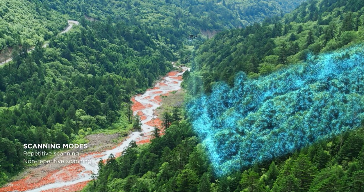
Figure 3. Drone LiDAR topography scanning process Illustration
To view an enhanced version of this graphic, please visit:
https://images.newsfilecorp.com/files/3834/275412_078ff38bb4c7dbeb_004full.jpg
Discussion of the Mora Gold-Silver Project
In August 2025, through its wholly owned subsidiary Maximum Company Colombia S.A.S., Max entered into a purchase agreement to acquire
Highlights
- The undrilled Mora Property encompasses over 40 historic workings, 5 active mines, a series of exposed polymetallic structures over 2,500m by 1,000m, adjacent to Aris Mining's (TSX: ARIS) (NYSE: AIMN) 9.2Moz Marmato Gold Operation (P&P Reserves: 31.3Mt@3.2 g/t Au for 3.2Mozs, M&I Resources: 61.5Mt@3.0 g/t Au for 6.0Moz, Inferred Resources: 35Mt at 2.4 g/t Au for 2.8Mozs ¹).
- Aris Mining's Marmato Property abuts the 2.8 km eastern boundary, and Collective Mining's (TSX: CNL) (NYSE: CNL) Guayabales Project abuts along 3.7 km north (Apollo Porphyry System), west, south, and vertical east boundaries of the Mora Property.
- Highlight, Mora Property channel sample results include (refer to Table 1)
- 45.0 g/t gold & 7,110 g/t silver over 1.0m; 32.0 g/t gold & 53 g/t silver over 1.0m.
- 27.0 g/t gold & 732 g/t silver over 1.0m; 8.9 g/t gold & 75 g/t silver over 1.5m.
Max advises investors that the gold mineralization at the Marmato gold deposit and the Apollo porphyry zone may not necessarily by indicative of similar mineralization at the Mora Property. Max further advises the QP has been unable to verify the information on Marmato and Guayabales and that the information is not necessarily indicative to the mineralization on the Mora Property.
In September 2025, Max reported the appointment of Mr. Sergio Cocunubo as Head Geologist, reuniting with key Technical Advisor Dr. Chris Grainger and Community Relations specialist Mr. John Henao, all key members of the Collective Mining and the Continental Gold team that developed the Buriticá Gold Deposit³ Deposit (P&P Reserves: 3.8Mozs at 6.9 g/t Au & 13Mozs at 24g/t Ag in 15.61Mt and M&I Resources: 4.4Mozs at 8.9 g/t Au & 14.6Mozs at 29 g/t in 14.02Mt plus Inferred Resources: 5.1Mozs at 8.9 g/t Au & 18Mozs at 29 g/t Ag in 16.2Mt³), sold to Zijin Mining for US
The Company's 2025 exploration program is well underway, includes collection of geological and geophysical data, channel sample all active and historical artisanal mines/workings, outcrops, airborne LiDAR, 3D geological/DTM/topographic modelling and delineation of drill targets. Exploration update is due shortly.
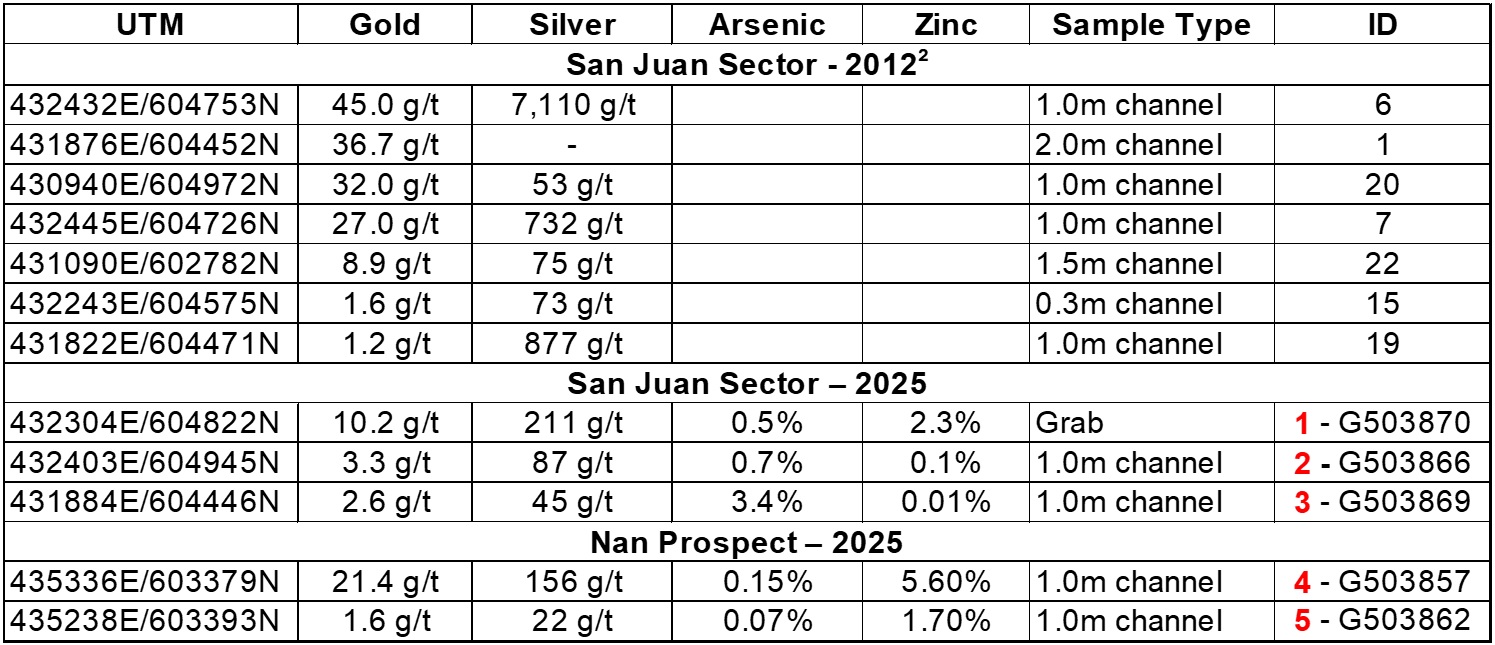
Table 1. Highlight Assay Results for 2012² and 2025 Field Investigations.
To view an enhanced version of this graphic, please visit:
https://images.newsfilecorp.com/files/3834/275412_max%20table%201.jpg
Corporate Update
Under the terms of the Agreement, whereby the Company's wholly owned Colombian subsidiary, Maximum Company Colombia S.A.S. ("Maximum") has the exclusive rights to acquire
The Company has entered into a debt settlement agreement with an arm's-length creditor to settle outstanding indebtedness totaling
In addition, the Company has granted 11,500,000 Performance Share Units ("PSUs") to certain consultants of the Company pursuant to the Company's Omnibus Equity Incentive Compensation Plan (the "Omnibus Plan"). The PSUs will vest upon the consultants completing one year of service with the Company. All PSUs are subject to a hold period of four months and one day. The PSUs have been granted under and are governed by the terms of the Company's Omnibus Plan.
Quality Assurance
Max adheres to a strict QA/QC program for sample handling, sampling, sample transportation and analyses. All 21 rock samples were taken by the Max consulting geologist, labelled, placed in sealed, securitized bags and shipped to ALS Lab's sample preparation facility in Medellin, Columbia. ALS Medellin is an ISO 9001: 2008 certified facility and is independent of Max. All samples were analyzed using ALS procedure ME-ICP61, a four-acid digestion with inductively coupled plasma finished. Over-limit gold is determined by ALS procedure Au-GRA21 a 30-gram fire assay with a gravimetric finish. Over-limit silver, lead, arsenic and zinc were determined by ALS procedure OG-62, a four-acid digestion with an atomic absorption spectroscopy finish.
At this early stage of exploration, Max has relied on the QA/QC protocol's employed by ALS.
Sierra Azul Copper-Silver Project in Colombia
Max's wholly owned Sierra Azul Copper-Silver Project sits along the Colombian portion of the world's largest producing copper belt (Andean belt). Max has an Earn-In Agreement ("EIA") with Freeport-McMoRan Exploration Corporation ("Freeport"), a wholly owned affiliate of Freeport-McMoRan Inc. whereby the fully funded USD
Florália Property in Brazil
The Florália Iron Property (mineral right 832.022/2018) in Brazil lies within Minas Gerais, Brazil's largest iron ore and steel producing State. The Property has established road access to rail terminal (15 km) linking to steel mills and shipping ports; roads connect to DSO buyers Vale (16 km) and ArcelorMittal (26 km) ensuring efficient logistics and market access. Max's technical team has significantly expanded the Florália Iron Geological Target from 8-12Mt at
Max's majority owned Max Iron Brazil Ltd. has entered into a non-binding letter of intent with Bolt Metals Corp. ("Bolt") whereby Bolt may acquire an option to earn a
Max cautions investors the potential quantity and grade of the iron ore is conceptual in nature, and further cautions there has been insufficient exploration to define a mineral resource and Max is uncertain if further exploration will result in the geological target being delineated as a mineral resource. Hematite mineralization tonnage potential estimation is based on in situ high-grade outcrops and interpreted and modelled magnetic anomalies. Density value used for the estimate is 2.8t/m³. Hematite sample grades range between 55
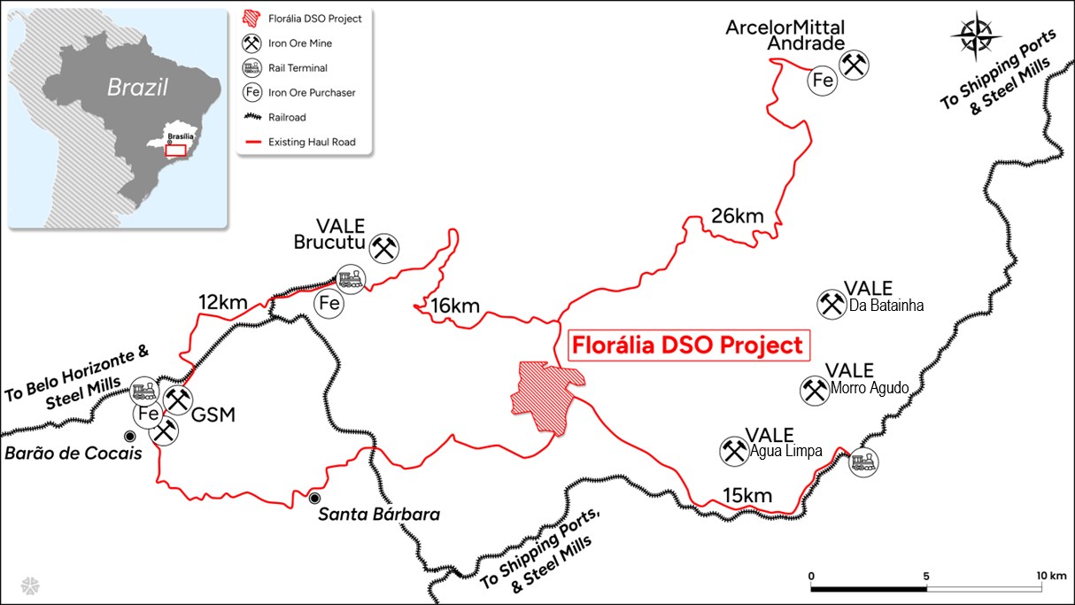
Figure 4. Florália Property located nearby infrastructure and markets
To view an enhanced version of this graphic, please visit:
https://images.newsfilecorp.com/files/3834/275412_078ff38bb4c7dbeb_007full.jpg
Qualified Person
The Company's disclosure of a technical or scientific nature in this news release was reviewed and approved by Tim Henneberry, P.Geo (British Columbia), a member of the Max Resource advisory board, who serves as a qualified person under the definition of National Instrument 43-101.
| Name | Highlights | Reference |
| News Release² Dec 20, 2012 | Crown Gold Corp. (TSXV: CWN) Mora Property | Scott Franko, senior consultant to Crown Gold and a registered Professional Geologist was designated as the Qualified Person under NI 43:101 for the Colombian Mining Project |
| Marmato Gold Deposit¹ | Aris Mining (TSX: ARIS) (NYSE: AIMN) | https://aris-mining.com/operation/reserves-and-resources/ |
| P&P Reserve: 31.28Mt at 3.16 g/t Au for 3.178Mozs | ||
| M&I Resources: 61.50Mt at 3.03 g/t Au for 5.997Mozs | ||
| Inferred Resource: 35.60Mt at 2.43 g/t Au for 2.787Mozs | ||
| Buriticá Gold Deposit³ | Zijin Mining - Continental Gold | https://www.zijinmining.com/global/program-detail-71741.htm |
| P&P Reserve: 3.8Mozs at 6.9g/t Au&13Mozs at 24g/t Ag in 15.61Mt | ||
| M&I Resource: 4.4Mozs at 8.9g/t Au&14.6Mozs at 29g/t in 14.02Mt | ||
| Inf. Resource: 5.1Mozs at 8.9g/t Au&18Mozs at 29g/t Ag in 16.2Mt |
Table 2. References
For more information, visit on Max Resource: https://www.maxresource.com/
For additional information, contact: Tim McNulty E: info@maxresource.com T: (604) 290-8100 Brett Matich T: (604) 484 1230
Neither TSX Venture Exchange nor its Regulation Services Provider (as that term is defined in the policies of the TSX Venture Exchange) accepts responsibility for the adequacy or accuracy of this release.
Except for statements of historic fact, this news release contains certain "forward-looking information" within the meaning of applicable securities law.
Forward-looking information is frequently characterized by words such as "plan", "expect", "project", "intend", "believe", "anticipate", "estimate" and other similar words, or statements that certain events or conditions "may" or "will" occur. Forward-looking statements are based on the opinions and estimates at the date the statements are made and are subject to a variety of risks and uncertainties and other factors that could cause actual events or results to differ materially from those anticipated in the forward-looking statements including, but not limited to delays or uncertainties with regulatory approvals, including that of the TSXV. There are uncertainties inherent in forward-looking information, including factors beyond the Company's control. There are no assurances that the commercialization plans for Max Resources Corp. described in this news release will come into effect on the terms or time frame described herein.
The Company undertakes no obligation to update forward-looking information if circumstances or management's estimates or opinions should change except as required by law. The reader is cautioned not to place undue reliance on forward-looking statements. Additional information identifying risks and uncertainties that could affect financial results is contained in the Company's filings with Canadian securities regulators, which filings are available at www.sedarplus.ca.
To view the source version of this press release, please visit https://www.newsfilecorp.com/release/275412