Exploits Launches High-Resolution Detailed Geophysics at Québec Gold Projects
Rhea-AI Summary
Exploits Discovery (OTCQB: NFLDF) launched high-resolution drone magnetic and VLF-EM surveys at its Fenton and Wilson gold projects in Québec to map structural controls and identify priority drill targets ahead of a planned winter drill program.
Key metrics: magnetic 270 line-km at Fenton and 700 line-km at Wilson; VLF-EM 135 line-km at Fenton and 350 line-km at Wilson; 50m line spacing at 35–40m altitude. The company recently agreed to sell Newfoundland assets for up to 3,547,100 shares at $2.48 (up to ~$8.8M), leaving Exploits with ~$10M cash and no debt.
Positive
- Company to have approximately $10M cash and no debt
- Drone magnetic surveys total 970 line-km across both projects
- VLF-EM surveys total 485 line-km to refine targets
- Fenton historical resource: 63,885 oz (426,173 t @ 4.66 g/t, non-NI 43-101)
- Wilson historical resource: 42,850 oz (187,706 t @ 7.1 g/t, non-NI 43-101)
Negative
- Historical resources at Fenton and Wilson are non-NI 43-101 and considered uncertain
- Sale consideration includes up to 3,547,100 shares, which may dilute existing holders
- Planned winter drilling depends on geophysics results; outcomes remain uncertain
News Market Reaction – NFLDF
In the Oct 8 session, NFLDF declined 1.04%, reflecting a mild negative market reaction.
Data tracked by StockTitan Argus on the day of publication.
AI-generated analysis. How Rhea-AI works. Not financial advice.
Surveys to map structural controls on gold mineralization and identify priority drill targets
Toronto, Ontario--(Newsfile Corp. - October 8, 2025) - Exploits Discovery Corp. (CSE: NFLD) (OTCQB: NFLDF) (FSE: 634) announces the commencement of high-resolution drone magnetic and VLF-EM surveys at its Fenton and Wilson gold projects in Québec. These surveys are aimed at identifying new areas of interest and gaining a more detailed understanding of the projects' known high-grade gold zones. Results from the surveys and this summer's field work, will guide the design of a winter drill program focused on expanding known resources and testing new zones of gold mineralization.
High-Resolution Detailed Geophysics at Québec Gold Projects
The geophysics crew will fly high-resolution drone magnetic and VLF-EM surveys across each property. The magnetic survey will cover 270-line kilometres at Fenton and 700-line kilometres at Wilson, while the VLF-EM survey will cover 135-line kilometres at Fenton and 350-line kilometres at Wilson.
Other highlights include:
- Drone magnetic and VLF-EM survey to cover the entire Fenton and Wilson properties
- Both surveys will use 50-metre line spacing at 35 to 40 metres above surface for high-resolution
- The drone magnetic survey will be run in two perpendicular directions to improve detail and help identify high-angle cross structures that trend parallel to historical survey lines.
Jeff Swinoga, President and CEO, comments: "We are excited to launch these high-resolution surveys at our Fenton and Wilson projects, which together with our field work will ultimately lead to drilling programs on these gold projects. The surveys are designed to map structural controls on gold mineralization and highlight new, high-priority drill targets across both properties. The results will greatly benefit our anticipated upcoming winter drilling programs, where we aim to expand known resources and test new zones of gold mineralization. With the recent announced sale of our Newfoundland properties to New Found Gold Corp. for up to 3,547,100 shares at 2.48 per share (for up to approximately
The Fenton and Wilson properties contain high-grade gold mineralization associated with regional geophysical conductors near intersections with high-angle cross structures. A summary of the work to date on each project is below.
Fenton Project
The Fenton project comprises 18 contiguous claims covering approximately 760.7 hectares, with year-round access via forestry roads.
A historical mineral resource estimate (non-NI 43-101 compliant)* reported 426,173 tonnes grading 4.66 g/t gold (Au), for 63,885 ounces of gold, including 23,643 ounces within the first 50 metres below surface. This estimate was prepared by Exploration Boréale Inc. (Denis Chénard, Ing., 2000), and based on a cut-off grade of 2.0 g/t Au and a minimum true width of 1.0 m.
Since that time, an additional 25 drill holes totaling more than 10,800 metres have been completed, which expanded the mineralized envelope along strike and to depth. Reported highlights include:
- DDH 1354-17-17: 0.9 g/t Au over 32.6 m from 405.6 m, including 12.1 g/t Au over 1.0 m (SOQUEM, 2018)
- DDH 1354-17-17: 3.4 g/t Au over 20.0 m from 556.0 m, including 29.6 g/t Au over 2.0 m (SOQUEM, 2018)
- DDH 1354-17-24: 1.1 g/t Au over 11.0 m from 660.0 m, including 8.2 g/t Au over 1.0 m (SOQUEM, 2018)
In addition to the Fenton Historical Resource and the immediate area, several other targets have been identified on the property (see figure 1), including:
- One with drill holes and a similar geophysical signature:
- 1391-17-20 returned 42.3 g/t Au over 5.1 m including 356.0 g/t Au over 0.6 m (Gagnon, 2018)
- 1391-20-36 (a second drill hole) returned 2.9 g/t over 11.0 m, including 25.7 g/t Au over 1.0 m (Gagnon, 2020)
- Four with surface grab samples and a similar geophysical signature:
- Multiple > 10.0 g/t Au grab samples with one reaching 90.1 g/t Au
- Nine with similar geophysical targets with no sampling to date but coincident NW trending Mag high and EM conductor axis
(Details of sampling, QA/QC, and analytical procedures for the 2012, 2017-2018 and 2020 SOQUEM programs are provided below in Appendix A).
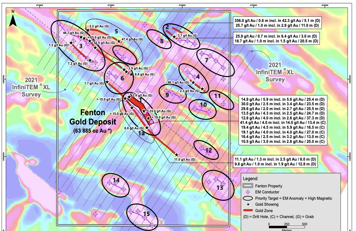
Figure 1. Fenton Property, showing historic results and InfiniTEM Survey (Cartier Resources Inc., 2021).
To view an enhanced version of this graphic, please visit:
https://images.newsfilecorp.com/files/6393/269598_e07fd92e74ffb9ab_002full.jpg
Wilson Project
The Wilson gold project comprises 42 contiguous claims covering 1,660 hectares, located just 15 kilometres east of Lebel-sur-Quevillon in Québec.
The project hosts multiple gold-bearing zones, including the high-grade Toussaint showing where a historical mineral resource estimate (non-NI 43-101 compliant)* reported 187,706 tonnes at 7.1 g/t gold totalling approximately 42,850 ounces of gold (conducted by Freewest Resources in 1994 based on 70 holes and 9,634 metres).
An additional 92 holes totaling over 22,000 metres have been drilled on the property since the MRE was calculated. The results have greatly expanded the mineralized envelop along strike and to depth and include the following reported results:
- DDH HMW 21-09: 13.11 g/t Au over 3.0 m from 121.0 m, including 38.0 g/t Au over 1.0 m (Yordanov, 2022)
- DDH HMW 21-08: 11.25 g/t Au over 3.0 metres from 104.0 m, including 30.9 g/t Au over 1.0 m (Yordanov, 2022)
- DDH WL17-15: 6.8 g/t Au over 4.0 m, including 16.1 g/t Au over 1.0 m (Cartier, 2017)
- DDH WL17-05: 24.8 g/t Au over 1.0 m and 5.0 g/t Au over 3.0 m; including 14.1 g/t Au over 1.0 m (Cartier, 2017)
In addition to the Toussaint Historical mineral resource and immediate area, at least seven other targets have been identified on the property (see figure 2):
- Six have highly anomalous drill intercepts and a similar geophysical signature including:
- DDH HMW 21-33: 17.31 g/t Au over 3.0 m including 58.8 g/t Au over 1.0 m (Yordanov, 2023)
- 64.6 g/t Au over 0.4 m
- DDH HMW 21-36: 5.8 g/t Au over 4.1 m (Yordanov, 2023)
- One has anomalous channel samples and a similar geophysical signature: 3.9 g/t Au over 2.0 metres
(Details of sampling, QA/QC, and analytical procedures for the 2017 Cartier and 2021-2022 Hawkmoon programs are provided in Appendix A).
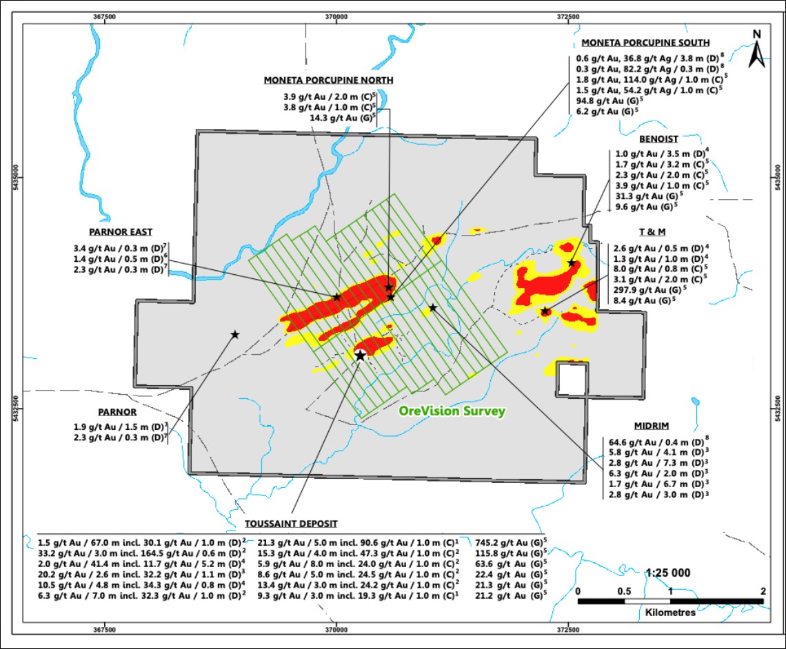
Figure 2. Wilson Property, showing historic results and OreVision Survey.
To view an enhanced version of this graphic, please visit:
https://images.newsfilecorp.com/files/6393/269598_figure298.jpg
*Historical Resource Disclaimers
Fenton (GM 56275; Chénard, 2000): The historical estimate predates NI 43-101, cannot be compared to CIM standards, and lacks complete QA/QC documentation. It is considered relevant but uncertain and suspect due to limited verification, incomplete sampling, and inconsistencies in survey control. A Qualified Person has not done sufficient work to classify the estimate as current, and the Company is not treating it as current. Additional work (data verification, re-logging, re-sampling, confirmation drilling, and updated modelling) would be required.
Wilson (GM 52557; Freewest, 1994): The historical estimate predates NI 43-101 and categories cannot be compared to CIM standards. It is considered relevant but uncertain and suspect given the limited tonnage, historical methodology, and absence of modern QA/QC. A Qualified Person has not done sufficient work to classify it as current, and the Company is not treating it as current. Additional work (data compilation, core verification, confirmation drilling, and updated modelling) would be required.
Sale of Newfoundland Properties
The Company recently announced the sale of its Newfoundland properties to New Found Cold Corp. for up to a total of 3,547,100 shares at a deemed price of
Qualified person statement
The scientific and technical information contained in this news release has been reviewed and approved by
Mark Richardson, P.Geo. (OGQ Permit No. 10929), a Qualified Person as defined by National Instrument 43-101.
About Exploits Discovery Corp.
Exploits Discovery is a Canadian gold exploration company focused on growing ounces in top-tier mining jurisdictions. Exploits' portfolio consists of the Hawkins Gold Project in Ontario and three advanced high-grade gold projects in Québec (Fenton, Wilson, and Benoist). The Company's strategy is to advance projects with district-scale potential through systematic exploration and partnerships, creating shareholder value through discovery and resource growth.
On Behalf of the Board,
/s/ "Jeff Swinoga"
President and CEO
For more information, please contact:
Jeff Swinoga
President & CEO
+1 (778) 819-2708
jeffswinoga@exploits.gold
https://exploitsdiscovery.com
Neither the Canadian Securities Exchange nor its Regulation Service Provider (as the term is defined in the policies of the Canadian Securities Exchange) accepts responsibility for the adequacy of accuracy of this news release.
Forward-Looking Statements
This news release contains certain forward-looking statements, which relate to future events or future performance and reflect management's current expectations and assumptions. Such forward-looking statements reflect management's current beliefs and are based on assumptions made by and information currently available to the Company. Readers are cautioned that these forward-looking statements are neither promises nor guarantees, and are subject to risks and uncertainties that may cause future results to differ materially from those expected including, but not limited to, market conditions, availability of financing, actual results of the Company's exploration and other activities, environmental risks, future metal prices, operating risks, accidents, labor issues, delays in obtaining governmental approvals and permits, and other risks in the mining industry. All the forward-looking statements made in this news release are qualified by these cautionary statements and those in our continuous disclosure filings available on SEDAR+ at www.sedarplus.ca. These forward-looking statements are made as of the date hereof and the Company does not assume any obligation to update or revise them to reflect new events or circumstances save as required by applicable law.
Appendix A
Summary prevoiusly disclosed drill collars
2012 SOQUEM (Fenton Program)
| Hole ID | Easting (mE) | Northing (mN) | Elevation (m) | Azimuth (°) | Dip (°) | Total Depth (m) |
| 1354-12-01 | 473369.7 | 5484827.3 | 376 | 217 | -46 | 192 |
| 1354-12-02 | 473252.8 | 5484868.1 | 373 | 214 | -46 | 291 |
| 1354-12-03 | 472928.9 | 5484488.5 | 370 | 34 | -45 | 132 |
| 1354-12-04 | 473487.4 | 5484819 | 370 | 215 | -45 | 291 |
| 1354-12-05 | 473376.7 | 5484420.6 | 369 | 216.7 | -45 | 102 |
| 1354-12-06 | 473378.6 | 5484422.2 | 369 | 36.5 | -60 | 390 |
| 1354-12-07 | 473475.3 | 5484346.3 | 366 | 37.1 | -53 | 232.4 |
| 1354-12-08 | 473575.3 | 5484266.7 | 366 | 38 | -46 | 246 |
| 1354-12-09 | 473617.2 | 5484239.3 | 367 | 35 | -46 | 243 |
| 1354-12-10 | 473312.2 | 5484452.9 | 369 | 33 | -52 | 411.5 |
| 1354-12-11 | 474015.1 | 5485612.6 | 370 | 216.1 | -46 | 201 |
| 1354-12-12 | 473893.3 | 5485113.2 | 370 | 216.6 | -44 | 282 |
NAD83 Zone 18
Source: GM 67354
2017 SOQUEM (Guercheville Program)
| Hole ID | Easting (mE) | Northing (mN) | Elevation (m) | Azimuth (°) | Dip (°) | Total Depth (m) |
| 1391-17-14 | 474721.5 | 5485395.3 | 372.3 | 219 | -44 | 171 |
| 1391-17-15 | 474844.2 | 5485401.7 | 371.1 | 220 | -44 | 171 |
| 1391-17-16 | 474925.9 | 5485340.2 | 369.7 | 220 | -45 | 132 |
| 1391-17-17 | 474842.7 | 5485233.5 | 369.5 | 305 | -45 | 162 |
| 1391-17-18 | 474844.7 | 5485229.8 | 369.5 | 223 | -44 | 174 |
| 1391-17-19 | 474123.8 | 5485588.9 | 370.1 | 220 | -60 | 207 |
| 1391-17-20 | 473923.1 | 5485653.6 | 368.7 | 220 | -58 | 231 |
| 1391-17-21 | 474076.7 | 5485695.1 | 369.6 | 217 | -56 | 300 |
NAD83 Zone 18
Source: GM 70782
2017 SOQUEM (Fenton Program)
| Hole ID | Easting (mE) | Northing (mN) | Elevation (m) | Azimuth (°) | Dip (°) | Total Depth (m) |
| 1354-17-13 | 473576.5 | 5484822.3 | 372 | 235.9 | -61.2 | 490 |
| 1354-17-14 | 473577 | 5484822.6 | 372 | 235.5 | -75.5 | 580 |
| 1354-17-15 | 473653.8 | 5484751.6 | 374 | 235.5 | -77.5 | 636 |
| 1354-17-16 | 473654.6 | 5484752.1 | 374 | 232.3 | -70.8 | 546 |
| 1354-17-17 | 473577.8 | 5484823 | 372 | 230.5 | -80 | 671.5 |
| 1354-17-18 | 473510.7 | 5484893.7 | 371 | 234.4 | -59.4 | 432 |
| 1354-17-19 | 473511 | 5484894 | 371 | 234.4 | -72 | 603 |
| 1354-17-20 | 473445.6 | 5484977.7 | 371 | 234.5 | -69.0 | 496 |
| 1354-17-21 | 473511.4 | 5484894.2 | 371 | 235.1 | -77.2 | 420.1 |
| 1354-17-21W | 473415.65 | 5484839.59 | -11.6 | 243.2 | -70 | 499.0 |
| 1354-17-22 | 473446 | 5484978 | 371 | 234 | -80.1 | 663 |
| 1354-17-23 | 473572.8 | 5484820.2 | 372 | 229.3 | -74.4 | 538 |
| 1354-17-24 | 473650.8 | 5484749.5 | 374 | 222.4 | -76.2 | 688 |
| 1354-17-25 | 473682 | 5484903 | 372 | 234.5 | -78.8 | 925 |
| 1354-17-25A | 473680.6 | 5484901.9 | 372 | 232.6 | -79.3 | 18 |
NAD83 Zone 18
Source:GM71366
2020 SOQUEM (Fenton)
| Hole ID | Easting (mE) | Northing (mN) | Elevation (m) | Azimuth (°) | Dip (°) | Total Depth (m) |
| 1391-20-33 | 473933 | 5485592 | 368.9 | 36 | -57 | 89.8 |
| 1391-20-34 | 473905 | 5485553 | 368.8 | 31 | -54 | 171 |
| 1391-20-35 | 473854 | 5485562 | 368.3 | 40 | -44 | 147 |
| 1391-20-36 | 473805 | 5485587 | 367.9 | 32 | -56 | 167 |
| 1391-20-37 | 473835 | 5485630 | 367.4 | 37 | -51 | 108 |
| 1391-20-38 | 473805 | 5485668 | 367.8 | 215 | -46 | 96 |
| 1391-20-39 | 473852 | 5485732 | 367.1 | 217 | -44 | 201 |
| 1391-20-40 | 473538 | 5485740 | 368 | 168 | -44 | 203.5 |
| 1391-20-41 | 473720 | 5485373 | 369.4 | 34 | -45 | 111.0 |
NAD83 Zone 18
Source: GM71834
Cartier 2017 (WL series):
| Hole ID | Easting (mE) | Northing (mN) | Elevation (m) | Azimuth (°) | Dip (°) | Total Depth (m) |
| WL17-01 | 370120 | 5433291 | 319 | 147.9 | -74.2 | 441 |
| WL17-02 | 370164 | 5433329 | 319 | 142.5 | -82 | 472 |
| WL17-03 | 370130 | 5433310 | 319 | 143.3 | -76 | 474 |
| WL17-04 | 370189 | 5433370 | 319 | 140.9 | -67.3 | 474 |
| WL17-05 | 370189 | 5433370 | 319 | 137.9 | -76.2 | 486.5 |
| WL17-06 | 370189 | 5433370 | 319 | 147.3 | -85.3 | 675 |
| WL17-07 | 370365 | 5433313 | 317 | 137 | -65 | 327 |
| WL17-08 | 370365 | 5433313 | 317 | 140 | -76 | 396 |
| WL17-09 | 370476 | 5433287 | 322 | 144.4 | -81.5 | 369 |
| WL17-10 | 370708 | 5433288 | 310 | 146 | -59.5 | 354 |
| WL17-11 | 370708 | 5433288 | 310 | 138.4 | -69.4 | 477 |
| WL17-12 | 370749 | 5433339 | 313 | 160.5 | -81.4 | 372 |
| WL17-13 | 370757 | 5433410 | 310 | 155.4 | -76.2 | 462 |
| WL17-14 | 370561 | 5433347 | 317 | 139.3 | -79 | 357 |
| WL17-15 | 370012 | 5433261 | 317 | 143.9 | -57.5 | 345 |
| WL17-16 | 370012 | 5433261 | 317 | 134.9 | -69.4 | 438 |
| WL17-17 | 370012 | 5433261 | 317 | 156 | -79.4 | 393 |
| WL17-18 | 370937 | 5433810 | 307 | 128.2 | -63.4 | 384 |
| WL17-19 | 370937 | 5433810 | 307 | 157.5 | -54 | 351 |
NAD83 Zone 18
Source: GM 70585
Viking Gold 2012 (VP series):
| Hole ID | Easting (mE) | Northing (mN) | Elevation (m) | Azimuth (°) | Dip (°) | Total Depth (m) |
| VP-11-01 | 370126.7 | 5433102.6 | 317.4 | 142 | -45 | 120 |
| VP-11-02 | 370313.2 | 5433139.8 | 324.5 | 132 | -45 | 114 |
| VP-11-03 | 370386.4 | 5433166.5 | 325.1 | 145 | -45 | 102 |
| VP-11-04 | 370497.7 | 5433181.4 | 315.8 | 131 | -46 | 102 |
| VP-11-05 | 370712.9 | 5433221.7 | 305.7 | 140 | -45 | 174 |
| VP-11-09 | 370112 | 5433793 | 319 | 145 | -45 | 162 |
| VP-11-10 | 370090 | 5433465 | 325 | 145 | -46.5 | 159 |
| VP-11-11 | 370127.6 | 5433189.3 | 317.4 | 140 | -55.2 | 210 |
| VP-11-12 | 370147.7 | 5433248.1 | 316.4 | 142.4 | -60.8 | 258 |
| VP-11-13 | 370319.3 | 5433263.5 | 319.2 | 141 | -45 | 207 |
| VP-11-14 | 370438.1 | 5433267.6 | 324.7 | 145 | -53.4 | 204 |
| VP-11-15 | 370531 | 5433309 | 325.2 | 143.3 | -51.5 | 219 |
| VP-11-16 | 370518.1 | 5433415.6 | 313.8 | 141 | -45 | 330 |
| VP-11-17 | 370600.1 | 5433209.1 | 306.8 | 141 | -55 | 102 |
| VP-11-18 | 370753.7 | 5433250.5 | 308.8 | 145 | -47.9 | 180 |
| VP-11-19 | 370796.7 | 5433276.3 | 305.8 | 145 | -48.3 | 180 |
| VP-11-20 | 370813.5 | 5433339.9 | 306.6 | 140 | -57 | 222 |
| VP-11-21 | 370265 | 5432894 | 311 | 175 | -55.5 | 192 |
| VP-11-22 | 370754 | 5433044 | 300.1 | 175 | -57 | 171 |
| VP-11-23 | 370756.2 | 5433334.9 | 310.6 | 140 | -50 | 255 |
| VP-11-24 | 370742.5 | 5433266.8 | 310.1 | 145 | -58 | 210 |
| VP-11-25 | 370055.4 | 5433293.7 | 319 | 142 | -53 | 333 |
| VP-12-26 | 370061.8 | 5433194.5 | 315.6 | 144 | -52 | 234 |
| VP-12-27 | 370065.2 | 5433146.7 | 315.7 | 144 | -45 | 157 |
| VP-12-28 | 370071.1 | 5433095.9 | 315.8 | 144 | -45 | 120 |
| VP-12-29 | 369984 | 5433048.5 | 315.4 | 144 | -45 | 120 |
NAD83 Zone 18
Source: GM 68527
Hawkmoon 2021-2022 (HMW series):
| Hole ID | Easting (mE) | Northing (mN) | Elevation (m) | Azimuth (°) | Dip (°) | Total Depth (m) |
| HMW21-01 | 370229 | 5433140 | 326 | 145 | -45 | 150 |
| HMW21-02 | 370228 | 5433076 | 327 | 150 | -55 | 100 |
| HMW21-03 | 370224 | 5433094 | 327 | 155 | -45 | 201 |
| HMW21-04 | 370149 | 5433090 | 326 | 145 | -60 | 201 |
| HMW21-05 | 370129 | 5433187 | 323 | 140 | -55 | 254.4 |
| HMW21-06 | 370192 | 5433115 | 321 | 145 | -60 | 201 |
| HMW21-07 | 370176 | 5433295 | 325 | 147 | -55 | 252 |
| HMW21-08 | 370260 | 5433164 | 329 | 145 | -55 | 201 |
| HMW21-09 | 370256 | 5433206 | 334 | 145 | -55 | 201 |
| HMW21-10 | 370284 | 5433114 | 331 | 155 | -45 | 201 |
| HMW21-11 | 370284 | 5433114 | 331 | 155 | -60 | 150 |
| HMW21-12 | 370263 | 5433103 | 326 | 145 | -70 | 102 |
| HMW21-13 | 370251 | 5433097 | 323 | 145 | -70 | 102 |
| HMW21-14 | 370378 | 5433198 | 315 | 145 | -55 | 201 |
| HMW21-15 | 370664 | 5433269 | 328 | 145 | -55 | 201 |
| HMW21-16 | 370726 | 5433215 | 317 | 140 | -45 | 150 |
| HMW21-17 | 370757 | 5433252 | 322 | 145 | -45 | 135 |
| HMW21-18 | 370823 | 5433286 | 319 | 160 | -60 | 150 |
| HMW21-19 | 370852 | 5433325 | 304 | 160 | -60 | 150 |
| HMW21-20 | 370861 | 5433473 | 309 | 145 | -60 | 210 |
| HMW21-21 | 370852 | 5433662 | 319 | 150 | -50 | 150 |
| HMW21-22 | 370861 | 5433621 | 305 | 145 | -60 | 201 |
| HMW21-23 | 370746 | 5433592 | 334 | 150 | -60 | 201 |
| HMW21-24 | 371008 | 5433595 | 316 | 160 | -60 | 150 |
| HMW21-25 | 371001 | 5433721 | 312 | 155 | -55 | 231 |
| HMW21-26 | 371052 | 5433674 | 312 | 150 | -60 | 198 |
| HMW21-27 | 371091 | 5433654 | 313 | 150 | -60 | 201 |
| HMW21-28 | 371067 | 5433623 | 309 | 155 | -45 | 186 |
| HMW22-29 | 370246 | 5433152 | 325 | 145 | -45 | 150 |
| HMW22-30 | 370272 | 5433176 | 320 | 145 | -55 | 201 |
| HMW22-31 | 370115 | 5433173 | 323 | 145 | -55 | 354 |
| HMW22-32 | 370162 | 5433290 | 320 | 145 | -55 | 450 |
| HMW22-33 | 370209 | 5433316 | 320 | 145 | -55 | 439 |
| HMW22-34 | 370275 | 5433222 | 320 | 145 | -55 | 252 |
| HMW22-35 | 370510 | 5433290 | 320 | 145 | -55 | 402 |
| HMW22-36 | 370980 | 5433647 | 320 | 155 | -60 | 300 |
| HMW22-37 | 371040 | 5433628 | 320 | 155 | -45 | 252 |
| HMW22-38 | 370235 | 5433842 | 320 | 325 | -45 | 201 |
NAD83 Zone 18
Source: Source: GM 73171
Historic Sampling, QAQC and Analyitcal Proceedures
Fenton (SOQUEM 2012) (Series 1354):
Core was sawn in half; samples averaged 1.0-1.5 m. Preparation at Techni-Lab, Ste-Germaine-Boulé: crushed to
Guercheville (SOQUEM 2017) (Series 1391):
Core was sawn in half; samples averaged 1.5 m. Preparation at ALS Chemex Val-d'Or: dried, crushed to
Fenton (SOQUEM 2017-2018) (Series 1354):
Core was sawn in half; samples typically 1.5 m. Preparation at ALS Val-d'Or; gold by 30 g fire assay (AAS finish) with gravimetric re-assay for >2 g/t Au. Select coarse-gold samples analyzed by Metallic Sieve (~1,000 g). Multi-element geochemistry by four-acid ICP-AES/MS and lithium metaborate ICP methods. SOQUEM inserted blanks, standards, and duplicates; ALS inserted internal controls. All labs accredited ISO 17025:2005. Intervals reported are core lengths; true widths are unknown. Source: GM 71366.
Geurcheville-Fenton (SOQUEM 2020) (Series 1391):
Core was sawn in half; preparation at ALS included crushing and pulverizing with silica blanks inserted between samples. Gold >5 g/t was re-analyzed by gravimetric finish; Pt/Pd ≥3 g/t and Ag ≥100 ppm re-analyzed by fire assay/ICP-OES; Ag ≥500 ppm re-analyzed by fire assay/gravimetric; base metals >
Wilson (Viking Gold 2012) (Series VP-12):
Core sawn in half; samples ~1.0-1.5 m. Preparation at ALS Val-d'Or: crushed to
Wilson (Cartier 2017) (Series WL):
Core was sawn in half; samples prepared at Techni-Lab Val-d'Or (crushed to
Wilson (Hawkmoon 2021-2022) (Series HMW):
Core was sawn in half; samples prepared at ALS Val-d'Or and analyzed at ALS Vancouver by 30 g fire assay (AAS finish). Samples >10 g/t Au re-analyzed by gravimetric finish. QA/QC included blanks, standards, and duplicates inserted regularly, with ALS internal controls. Results were within expected ranges. Labs accredited ISO 17025:2005. Intervals reported are core lengths; true widths are unknown. Source: GM 73171.
Citations for Previously Disclosed Results
- Cartier Resources Inc. (2017). Rapport de la campagne de forage 2017 - Projet Wilson, canton de Verneuil, Québec. Assessment submission to the Ministère des Ressources naturelles du Québec.
- Cartier Resources Inc. (2021, November 29). Cartier's exploration work in progress on the Fenton property. Press release. Retrieved from https://ressourcescartier.com/press-releases/cartiers-exploration-work-in-progress-on-the-fenton-property/.
- Datac Géoconseil Inc. (1998). Rapport d'évaluation - Propriété Fenton, canton de Fenton, Abitibi, Québec. Prepared for Exploration Boréale Inc. Assessment report GM 56275, Ministère des Ressources naturelles du Québec.
- Exploration Boréale Inc. (Chénard, D., Ing.). (2000). Évaluation de l'inventaire minéral aurifère, gîte Fenton. Assessment report GM 56275, Ministère des Ressources naturelles du Québec.
- Fekete, M. (1994). Rapport d'exploration et d'estimation des ressources minérales, projet Toussaint, canton de Verneuil, Abitibi, Québec. Prepared for Freewest Resources Canada Inc. Assessment report GM 52557, Ministère des Ressources naturelles du Québec.
- Gagnon, J.-F. (2018). Rapport d'exploration, année 2017, propriété Guercheville 2014-1 (1391), feuillet 32G/11. GM70782. SOQUEM Inc., Ministère de l'Énergie et des Ressources naturelles du Québec.
- Gagnon, J.-F., & Fortin Rhéaume, J.-D. (2020). Rapport d'exploration: Cartographie été 2019 et forage hiver 2020, propriété Guercheville 2014-1 (1391), feuillet SNRC 32G/11. SOQUEM Inc., Ministère de l'Énergie et des Ressources naturelles du Québec.
- SOQUEM Inc. (2012). Rapport de travaux d'exploration - Projet Fenton (GM 67354). Ministère des Ressources naturelles et de la Faune du Québec, SIGEOM Assessment File. 149 p.
- SOQUEM Inc. (2018). Programme de forage - Gîte Fenton (1354): méthodologie, QA/QC et résultats analytiques. Internal report and assessment submission.
- Viking Gold Exploration Inc. (2011). Rapport des travaux d'exploration 2011-2012, projet Fenton, Abitibi, Québec. Assessment report GM 68445, submitted to the Ministère des Ressources naturelles et de la Faune du Québec.
- Yordanov, G. M. (2022, December 10). Assessment report on the 2021-2022 diamond drill program completed on the Wilson Property, Verneuil Township, Québec (NTS 32F02). GMY Consulting Inc. for Hawkmoon Resources Corp.
- Yordanov, G. M. (2023, June 27). Assessment report on the 2022 diamond drill program completed on the Wilson Property, Verneuil Township, Québec (NTS 32F02). GMY Consulting Inc. for Hawkmoon Resources Corp.
![]()
To view the source version of this press release, please visit https://www.newsfilecorp.com/release/269598