
QIMC Reports Record 24.3% Clean Natural Hydrogen at Bennett Hill DDH-26-04 and Begins Technical Evaluation of Pilot-Scale Development Pathway and Clean Energy Generation
Rhea-AI Summary
Quebec Innovative Materials (CSE: QIMC, OTCQB: QIMCF) reported new mud-gas results from diamond drill hole DDH-26-04 at Bennett Hill, Nova Scotia, including a peak 24.3% H₂ reading at 707 m, the highest single hydrogen value in its 2026 Advocate Area program.
Across the full hole, 104 of 284 IsoJar samples returned ≥1% H₂, 23 ≥5% and 10 ≥10%, with percent-level hydrogen sustained to within 39 m of the 818 m end of hole. Methane was recorded at approximately 0% and CO₂ at or below 0.2%, consistent with earlier holes DDH-26-01, -02 and -03 at Eatonville Road, 15 km away. According to QIMC, these four holes support a working model of a district-scale, structurally controlled clean natural hydrogen system along the Cobequid-Chedabucto Fault Zone, and the company has begun technical evaluation of a potential pilot-scale characterization and clean energy generation pathway for the Advocate Area.
Positive
- 24.3% peak hydrogen at 707 m in DDH-26-04, highest yet in 2026 program
- 104 of 284 samples at or above 1% H₂ across DDH-26-04
- Hydrogen remains at percent levels to within 39 m of 818 m hole bottom
- Consistently low methane (~0%) and CO₂ (≤0.2%) across four 2026 holes
- Percent-level hydrogen confirmed at two drill centres 15 km apart
- Company initiating technical evaluation of pilot-scale development and clean energy generation
Negative
- Pilot-scale and commercial development remain at evaluation stage with no production decision disclosed
- Key alteration and petrophysical intervals have laboratory assays and porosity data pending, delaying full reservoir characterization
AI-generated analysis. How Rhea-AI works. Not financial advice.




Multiple Percent-Level Hydrogen Readings and a Consistently Clean, Near-Zero Methane Gas Signature Across Four Drill Holes at Two Drill Centres 15 Kilometres Apart Support QIMC's District-Scale Natural Hydrogen Energy Model
- Peak mud-gas reading of
24.3% H₂ recorded at 707 metres in DDH-26-04 - the highest single hydrogen reading yet recorded across QIMC's four-hole 2026 Advocate Area drilling program
Six readings ≥
10% H₂ and 46 readings ≥1% H₂ recorded across the newly reported 250 m to 818 m interval of DDH-26-04, out of 284 mud-gas samples collected across the full holePercent-level hydrogen sustained to within 39 metres (from 764 to 803 m) at the end of hole DDH-26-04 (
11.4% H₂ at 779 m); methane recorded at approximately0% , CO₂ at or below0.2% and SO₂ at0.01% ±0.01% throughout, consistent with the low-methane signature reported at DDH-26-01, -02 and -03DDH-26-04 completed to a final depth of 818 metres at Bennett Hill, Nova Scotia
Combined with DDH-26-01, DDH-26-02 and DDH-26-03 at Eatonville Road, results support a working model of a hydrogen system extending across at least 15 kilometres of the Cobequid-Chedabucto Fault Zone
Company beginning technical evaluation of the pathway toward pilot-scale characterization and clean energy generation of the Advocate Area clean hydrogen system
Montreal, Quebec--(Newsfile Corp. - July 20, 2026) - Quebec Innovative Materials Corp. (CSE: QIMC) (OTCQB: QIMCF) (FSE: 7FJ) ("QIMC" or the "Company") today reported new mud-gas geochemical results from the 250-metre to 818-metre interval (final depth) of diamond drill hole DDH-26-04 at Bennett Hill, Nova Scotia, including a peak reading of
Taken together with previously reported results from DDH-26-01, DDH-26-02 and DDH-26-03 at the Eatonville Road area — approximately 15 kilometres from Bennett Hill — the Company considers the DDH-26-04 results to be an important data point supporting its working geological model of a district-scale, structurally controlled clean natural hydrogen system across the Advocate Area and Canada's longest reported clean natural hydrogen corridor and system.
Highlights – DDH-26-04 (250 m – 818 m Interval, Final Depth)
Peak and repeated high-range readings. A peak reading of
24.3% H₂ at 707 metres, together with19.2% H₂ at 674 m,18.1% H₂ at 671 m,12.4% H₂ at 665 m,11.9% H₂ at 287 m,11.4% H₂ at 779 m, and9.8% H₂ at 668 m.Broadly elevated, not isolated. Of 284 co-collected IsoJar mud-gas samples across the full hole (14 m-815 m), 104 returned readings at or above
1% H₂, 23 at or above5% H₂, and 10 at or above10% H₂ — consistent with the Company's characterization of repeated, rather than single, elevated readings.Sustained toward final depth. Percent-level readings continued to within 39 metres of the bottom of the hole (
11.4% H₂ at 779 m;8.3% H₂ at 776 m), indicating the system remained open and did not weaken toward the base of DDH-26-04.Low-methane, low-CO₂ signature maintained. Methane (CH₄) was recorded at approximately
0% and carbon dioxide (CO₂) at or below0.2% across the 250-818 m interval, consistent with the hydrogen-dominant, low-methane and low-CO₂ gas signature reported at DDH-26-01, DDH-26-02 and DDH-26-03.Corroborating headspace data. Companion 2-litre bottle headspace sampling across the 281-818 m interval returned hydrogen enrichment in similar intervals (for example, 1.3% H₂-equivalent at 371 m), at generally lower absolute values consistent with the greater dilution inherent to the headspace method as described in prior Company disclosures.
Hole complete. DDH-26-04 was completed to a final depth of 818 metres.
Geological and Structural Observations – DDH-26-04
DDH-26-04 was collared on or about June 9, 2026 at a planned azimuth of 355° (northwest) per the Diamond Drill Report header and completed at a final downhole depth of 818 metres. Downhole survey measurements filed with the updated Diamond Drill Report record hole bearings of approximately 356° to 012° (true north) along the hole and a dip of approximately -69° at the first survey station (-14 m), progressively flattening to approximately -51° by 794 m. All depths in this release are downhole (core-length) measurements; owing to this deviation, true vertical depths are shallower — on a preliminary minimum-curvature basis, approximately 705 metres at end of hole and approximately 620 metres at the 707 m peak reading. The hole intersects a structurally complex package dominated by variably deformed syenogranite intruded by mafic dykes and, in its upper 43 metres, mafic volcanic rock, with a discrete zone of faulted sedimentary screens (siltstone, argillite and polymictic sedimentary breccia) between approximately 409 m and 425 m - interpreted as a fault-bound block consistent with the Company's R2G2™ (Reactivated Rift and Graben Geostructure) exploration model.
Pervasive brittle structure, not a single fault. The updated Diamond Drill Report records 32 intervals of fault breccia (between approximately 132 m and 538 m) and 86 discrete intervals of broken core (between approximately 48 m and 652 m), together with a discrete fault zone and associated fault gouge at 17.1-17.8 m — indicating that roughly the upper 650 metres of DDH-26-04 is affected by distributed faulting and fracturing rather than a single, isolated structure, with the most intense fracturing concentrated above approximately 250 metres.
The highest hydrogen interval sits within a healed structural corridor. The 665-707 m interval hosting the hole's strongest readings, including the
24.3% H₂ peak at 707 m, lies within a variably deformed mafic dyke-syenogranite complex described in field logs as containing hydrothermal, quartz- and hematite-healed breccia and fracture sets oriented over a wide range of angles to the core axis — consistent with a repeatedly reactivated structural corridor. Core quality (RQD) through this interval remains generally high (75-100% ), indicating the fracture network here is substantially healed rather than open rubble.A direct structural-gas correlation at 776-779 m. Core-quality data show the only interval of
0% RQD logged in the hole at 776-779 m — where the field log records near-total core loss (approximately 20 cm of core recovered over the 3-metre run) and queries a possible open void — and where magnetic susceptibility also falls to approximately 0 SI×10⁻³ over 777-778 m against a local background of 3-5 SI×10⁻³ - both consistent with a discrete, more intensely broken structural break. This interval directly brackets two of the strongest readings in the lower part of the hole (8.3% H₂ at 776 m and11.4% H₂ at 779 m), providing one of the clearest direct correlations yet observed on the project between a specific structural feature and elevated hydrogen.Pressurized water zone at approximately 617 m. Company field personnel have reported a pressurized water interval at approximately 617 m encountered during drilling of DDH-26-04, with water observed overflowing at surface at the wellhead. The Diamond Drill Report logs a mm-scale fault gouge at 618.9 m and an associated pyrite clot at 616.65 m in this same interval, consistent with a hydraulically active structure at this depth.
Competent, low-porosity relatively undeformed syenogranite above the deep hydrogen zone. On a preliminary basis, the Company interprets the thick, dominantly syenogranitic block between approximately 250 m and 640 m as a competent, low-porosity interval with the potential to act as a comparatively impermeable cap above the deeper 665-818 m hydrogen-bearing zone. Diamond Drill Report data support a tight rock-mass characterization of this block: core recovery is logged at
100% throughout, with Rock Quality Designation (RQD) averaging approximately90% (median93% ) and no logged sub-interval falling below approximately57% — markedly more competent than the pervasively faulted upper 250 metres of the hole. Field logs repeatedly describe the block as massive and silicified — including "texturally and mineralogically constant" from 486.1 m to 535.3 m and an "overall silicified section" at 575-577 m — with fracture and breccia sets dominantly healed by quartz, hematite and silica infill, including, in the brecciated syenogranite toward the base of the block, the explicit observation that "quartz-filled fractures do not extend into the matrix." Notably, open porosity (vugginess) is essentially absent from the field logs across the 250-640 m block — in sharp contrast to the vug-rich, altered interval below approximately 700 m — consistent with a low-porosity fractured granitic mass. Petrophysical samples of the block (PSQIMC-26-136 through PSQIMC-26-140, between approximately 484 m and 579 m) have been collected and laboratory porosity and permeability results are pending. Diamond Drill Report additionally records four petrophysical samples through the deeper altered zone (PSQIMC-26-144 through PSQIMC-26-147, approximately 694 m to 782 m), which will allow direct laboratory comparison of the proposed sealing block against the vuggy, altered interval beneath it.Increasing alteration intensity from approximately 690 m to final depth. Field logs for the 690-818 m interval repeatedly note increasing vugginess (open porosity) with depth — including at 700-702 m (logged as "core locally very vuggy"), 718-719 m, 741-752 m, 767 m, 773-776 m, 783-785 m, 791-803 m and 804-806 m — together with increasing hematization (for example, 742.0-745.7 m is logged as "intense K-spar to hematitic alteration resulting in a salmon-pink color," with further hematization at 768.7-769.7 m and 804-806 m), increasingly intense brecciation from approximately 741 m to 759 m, and, at 801-803 m, vugs explicitly associated in the field log with "removal of 'dark' mineral (likely magnetite) from breccia matrix." Taken together, these observations are consistent with progressive, structurally controlled magnetite-to-hematite (Fe²⁺-to-Fe³⁺) redox alteration and increasing rock porosity with depth toward final hole depth, in a package of granite that field logs otherwise describe as increasingly fractured and "tortured" - texturally consistent with rock that has undergone repeated interaction with an actively altering fluid.
Preliminary IOCG-style alteration analogy — assays to be submitted for laboratory analysis. The combination of pervasive structural and hydrothermal brecciation, hematite-rich alteration, and localized magnetite destruction/redistribution documented in DDH-26-04 is texturally similar to alteration styles observed in Iron-Oxide-Copper-Gold ("IOCG") mineral systems elsewhere. In particular, the Diamond Drill Report documents a long, continuously altered interval from approximately 690 m to final depth at 818 m in which iron-oxide minerals are more concentrated than elsewhere in the hole: interstitial and elongated magnetite (mm-wide, cm-long grains aligned along the fabric) is logged throughout the host syenogranite, together with pervasive K-spar-to-hematite alteration — including 742.0-745.7 m, logged as "intense K-spar to hematitic alteration resulting in a salmon-pink color," further hematization at 768.7-769.7 m and around 805 m, and, at 801-803 m, vugs associated in the field log with removal of a dark mineral from the breccia matrix. Core samples spanning this altered interval, including lithogeochemical samples K685299 through K685302 (approximately 694 m to 783 m), will be submitted to the laboratory for assay analysis.
District-Wide Context: Four Holes, One Structural Corridor
DDH-26-04 is located at Bennett Hill, approximately 15 kilometres from the Eatonville Road drill area where DDH-26-01, DDH-26-02 and DDH-26-03 were completed earlier in the 2026 program. Previously disclosed results from DDH-26-01, DDH-26-02 and DDH-26-03 are described in the Company's news releases dated March 10, March 19, May 20, June 18 and June 29, 2026; depth references reflect measurements recorded at each hole and are not equivalent calibrated values between holes.
The Company considers the combination of (i) percent-level hydrogen at two structural centres 15 kilometres apart, (ii) a consistent low-methane, low-CO₂ gas signature across all four holes, and (iii) hydrogen concentrations that remain elevated or increase with depth in every hole drilled to date, to be supportive of a district-scale, rather than point-source, natural hydrogen system along the regional Cobequid-Chedabucto Fault Zone. The
Toward Commercial Development
QIMC is evaluating what a hydrogen system of this apparent scale and consistency could mean for a longer-term pilot or commercial development pathway at the Advocate Area. This evaluation includes ongoing monitoring of, and engagement with, evolving provincial and federal frameworks applicable to natural hydrogen exploration, pilot testing and future production in Nova Scotia, Québec and Ontario as well as evaluation of potential technical and development partnerships to advance any future pilot-scale production model.
Management Commentary
"DDH-26-04 is a milestone hole for QIMC — and, we believe, a meaningful moment for clean natural hydrogen in North America. We set out this season to answer one question: is the Advocate Area a single anomaly, or a district? Four holes in, the data increasingly point to a district. We now have percent-level hydrogen at two drill centres 15 kilometres apart, a peak reading of
Scientific Review and Commentary
DDH-26-04 drill hole, located at the summit of Bennett Hill, was designed to continue evaluating the Advocate natural hydrogen corridor, and more specifically its presumed northeastward extension along the deformation corridor situated between the South Cobequid and North Cobequid faults in Fraserville area. This area of the Cobequid Highlands is characterized by a predominantly igneous geology, dominated by felsic intrusive rocks associated with the Carboniferous Apple River pluton. The igneous rocks in the vicinity of the drill site are highly deformed and altered, and they coincide with strong hydrogen soil-gas anomalies identified during the initial 2025 survey. Together with Soil-Gas geochemistry and drilling results from West Advocate, these anomalies demonstrated the presence of a multi-kilometre natural hydrogen system, thereby validating the R2G2™ model originally applied to prioritize exploration in this part of the Maritimes.
DDH-26-04 drill hole begins in basaltic rocks to the south and quickly intersects the felsic units of the Apple River pluton. At Bennett Hill, the pluton is composed mainly of variably deformed syenogranite, and it also contains aphyric mafic dykes. The dominant structural fabrics include tectonic and hydrothermal breccias, zones of intensely fractured rock (low RQD), fault planes, and, more rarely, fault gouge. As highlighted in the press release, the felsic rocks of the pluton are locally affected by strong alteration characterized by hematite, magnetite, and chlorite, with additional zones of silicification and carbonatization. Sulfides occur in several intervals, typically associated with intensely altered zones. The style, mineralogy, and thickness of these alteration zones are consistent with an IOCG-type hydrothermal system. It is worth noting that numerous IOCG-style occurrences have been documented along the Cobequid Fault Zone over a strike length of approximately 300 km. However, the western segments of the system, such as Advocate and Bennett Hill, were not previously recognized as hosting this type of hydrothermal mineralization. In this context, both the location of DDH-26-04 and the substantial volume of altered felsic rocks intersected in the drill hole are particularly significant.
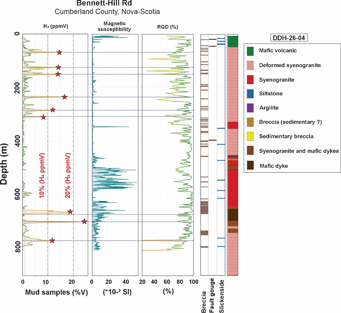
Figure 1. Diagram showing the changes in H2 (ppmV) concentrations (drill mud) measured in hole DDH-26-04 and the magnetic susceptibility measurements and RQD (%) measured on the drill core. The main lithologies and some structural elements are also shown in the figure.
To view an enhanced version of this graphic, please visit:
https://images.newsfilecorp.com/files/7968/305760_89c578e76471ca65_001full.jpg
A redundancy analysis (RDA) was conducted to provide a preliminary assessment of the relationship between hydrogen concentrations (H₂, log₁₀-transformed) measured in the drilling mud from DDH-26-04 and the distance (in metres) separating each measurement point from the nearest breccia zone, fault gouge, or fault mirror (slickenside), while also accounting for geological unit. The model explains
Geology contributes more modestly once structural distances are accounted for (partial R² =
About Québec Innovative Materials Corp. (QIMC)
Québec Innovative Materials Corp. (CSE: QIMC) (OTCQB: QIMCF) (FSE: 7FJ) is a North American exploration and development company advancing a portfolio of natural hydrogen and critical mineral interests. The Company is advancing its exploration model across Québec, Ontario, Nova Scotia and Minnesota through the application of its proprietary R2G2™ (Reactivated Rift and Graben Geostructure) framework. QIMC is focused on responsible exploration, technical innovation, and the advancement of natural hydrogen opportunities that may contribute to future clean-energy development initiatives. The Company's exploration at the Advocate Area involves no hydraulic fracturing and no reservoir stimulation.
For Further Information
QUÉBEC INNOVATIVE MATERIALS CORP.
John Karagiannidis
President & Chief Executive Officer
Email: info@qimaterials.com
Tel: +1 514-726-7058
Sampling, Methodology and Data Verification
Mud-gas readings reported in this release are preliminary and are based on co-collected IsoJar headspace samples taken at regular depth intervals during the drilling of DDH-26-04, using a portable EAGLE II gas analyzer fitted with a higher measurement range than the unit used in the upper 100 metres, consistent with the methodology disclosed by the Company on June 18 and June 29, 2026. Companion 2-litre bottle headspace samples were collected using the Company's standard headspace protocol (1,300 mL water / 700 mL air at room temperature and pressure) as described in the Company's March 10, 2026 disclosure for DDH-26-01.
The results in this release below 250 metres have been compiled from the Company's original handwritten field and laboratory data sheets. They have been independently verified against certified gas cylinder standards under the supervision of Prof. Marc Richer-LaFlèche, P.Geo., of INRS, prior to any public disclosure.
Scientific and Technical Information
The scientific and technical information in this news release has been reviewed and approved by Prof. Marc Richer-LaFlèche, P.Geo., of the Institut national de la recherche scientifique (INRS), a technical consultant to the Company.
Natural hydrogen is a gaseous substance and is not a "mineral resource" or "mineral reserve" as those terms are defined under National Instrument 43-101 - Standards of Disclosure for Mineral Projects ("NI 43-101") and the CIM Definition Standards. The hydrogen readings disclosed in this news release are provided as exploration-stage geochemical information and general corporate disclosure. NI 43-101 mineral resource and mineral reserve definitions and classifications do not apply to the hydrogen readings reported herein.
Cautionary Statement Regarding Mud-Gas Readings
Investors are cautioned that mud-gas and headspace gas readings are preliminary, exploration-stage geochemical indicators only. They are preliminary laboratory measurements obtained from IsoJar headspace samples. They are not mineral resources or mineral reserves, are not indicative of the presence, volume, concentration, flow rate, deliverability or commercial recoverability of any natural hydrogen accumulation, and should not be relied upon as such. There is no guarantee that elevated hydrogen readings will be independently verified, calibrated, or translate into an economically recoverable resource. References to "record," "highest," "strongest" or similar terms reflect the Company's review of its own records and are not statements of independently verified fact.
Neither the Canadian Securities Exchange nor its Regulation Services Provider (as that term is defined in the policies of the Canadian Securities Exchange) accepts responsibility for the adequacy or accuracy of this release.
Forward-Looking Statements
This news release contains "forward-looking information" and "forward-looking statements" within the meaning of applicable Canadian securities laws, including statements regarding the interpretation and significance of hydrogen readings at DDH-26-04 and other holes; the existence, extent, continuity or scalability of any hydrogen corridor or system; the relationship between Bennett Hill and the Eatonville Road drill area; any potential pilot-scale or commercial hydrogen production pathway, partnership or regulatory development; and results expected from continued sampling, drilling, and laboratory calibration. Such statements are based on assumptions and are subject to known and unknown risks and uncertainties — including that readings may not be confirmed by laboratory analysis, that geochemical indicators may not reflect a recoverable resource, that no decision has been made to proceed with pilot or commercial production, and risks relating to financing, permitting, weather, markets and general economic conditions — that may cause actual results to differ materially from those expressed or implied. Readers are cautioned not to place undue reliance on forward-looking statements. Except as required by applicable law, the Company disclaims any obligation to update or revise any forward-looking statements.

To view the source version of this press release, please visit https://www.newsfilecorp.com/release/305760