Sun Summit Strengthens Cu-Au Porphyry Potential at the JD Project, Toodoggone District: Defines an Open-Ended 8.5 km Long IP Anomaly
Rhea-AI Summary
Sun Summit Minerals (OTCQB: SMREF) has reported significant findings from its induced polarization (IP) survey at the JD Project in British Columbia's Toodoggone Mining District. The company has identified an impressive 8.5 km long chargeability-high anomaly along the McClair Creek alteration zone, substantially enhancing the project's copper-gold porphyry potential.
The survey, covering over 31-line kilometers across eight northeast-southwest oriented lines, revealed a broad anomaly spanning 8.5 by ~2 kilometers that remains open to the north and south. Notably, only 850 meters of the anomaly has been tested by drilling, with all five historic drill holes intersecting porphyry-related alteration and mineralization.
The company is currently conducting geological mapping and prospecting surveys, with additional soil survey data being compiled to refine drill targets. The McClair Creek anomaly is strategically located 17 km north of Amarc Resources' Aurora discovery.
Positive
- Discovery of an extensive 8.5 km long chargeability-high anomaly indicating strong copper-gold mineralization potential
- All 5 previous drill holes successfully intersected porphyry-related alteration and mineralization
- Strategic location 17 km north of Amarc Resources' Aurora discovery
- Ongoing geological mapping and soil surveys to refine drill targets
Negative
- Only 850 meters of the 8.5 km anomaly has been tested by drilling
- Additional IP surveying required to infill widely spaced lines
- Most of the large-scale anomaly remains untested
News Market Reaction
On the day this news was published, SMREF gained 2.64%, reflecting a moderate positive market reaction.
Data tracked by StockTitan Argus on the day of publication.
Vancouver, British Columbia--(Newsfile Corp. - September 18, 2025) - Sun Summit Minerals Corp. (TSXV: SMN) (OTCQB: SMREF) ("Sun Summit" or the "Company") is pleased to report results from a recently completed induced polarization (IP) survey across the JD Porphyry Trend at the JD Project, Toodoggone Mining District, north-central British Columbia.
Highlights:
New IP data enhances the JD Porphyry Trend: New chargeability and resistivity data demonstrate strong prospectivity for porphyry-related copper-gold mineralization along the JD Porphyry trend.
Untested anomalies: Only 850 meters of the 8.5 km long chargeability anomaly has been tested by drilling, where all 5 widely-spaced holes from 2013 and 2018 intersected porphyry-related alteration and mineralization (see February 5th, 2025, news release).
Follow-up programs ongoing: Geological mapping and prospecting surveys along the McClair Creek alteration zone are ongoing. Data from recently completed soil surveys along parts of the JD Porphyry trend are being compiled and interpreted to refine drill targets.
Phase II IP Survey: a subsequent phase of closely-spaced IP survey south of the Creek Zone is newly completed and results are being integrated with the 2024 IP survey historical data and with the current 3D model of the Creek zone.
"We have now defined a broad 8.5 km long chargeability-high anomaly at JD, significantly enhancing the project's copper-gold porphyry potential along the McClair Creek alteration zone," said Niel Marotta, CEO of Sun Summit Minerals. "This impressive alteration zone transects the JD Porphyry trend, yet remarkably, only five historic drill holes have tested it. The vast majority of this large-scale anomaly remains untested and represents a high-priority area for further target definition and exploration."
The JD Porphyry Trend IP Survey
The IP survey across the JD Porphyry trend consisted of over 31-line kilometers across eight northeast-southwest oriented lines. Line spacing varied from 500 to 1,200 meters depending on design depth of earlier survey arrays (Figure 1). The 2025 survey was designed to characterise and detect subsurface sulfide mineralization associated with pronounced magnetic anomalies and strong hydrothermal alteration observed along McClair creek (see February 5th, 2025, news release). The IP survey expanded on previous surveys that defined a north-south trending, open ended, high-chargeability anomaly. New and historic data was compiled and inverted (Figures 1 and 2).
The broadly, north-south oriented >18 mv/v McClair Creek chargeability-high anomaly spans 8.5 by ~2 kilometers and is open to the north and south (Figure 2). The broad anomaly is locally spatially coincident with discrete strong magnetic-high anomalies (Figure 2) and near the Belle South target, a strong resistivity-high anomaly. The intensity of the chargeability anomaly increases with depth, particularly to the north where the anomaly increases to +40 mv/v near the Fericrete and Oxide Peak targets (Figure 1).
Besides five widely-spaced drill holes near the McClair target in 2013 and 2018 (Figure 1), no other chargeability anomaly along the 8.5 km trend has been drill tested. Results from the five McClair holes (see February 5th, 2025 news release) suggests the entire trend may also be prospective for porphyry-related mineralization.
The McClair Creek anomaly is along trend, 17 km north of Amarc Resources' Aurora discovery (Figure 3). Porphyry-related copper and gold mineralization at Aurora is spatially associated with strong coincident chargeability-high and resistivity-high anomalies centered on a magnetic-high anomaly1.
Next Steps
This new chargeability and resistivity data supports the strong prospectivity for partially concealed, porphyry-related copper-gold mineralization proximal to the McClair Creek alteration zone (Figure 1). Additional IP surveying is warranted to infill widely spaced lines and to extend the survey footprint to the north and south (Figure 3).
Data from recently completed soil surveys along parts of the JD Porphyry trend are being compiled and interpreted to refine drill targets. Data from these surveys together with results from ongoing geological mapping and prospecting along the McClair Creek alteration zone (Figure 1) will be used to inform drill targeting and testing.
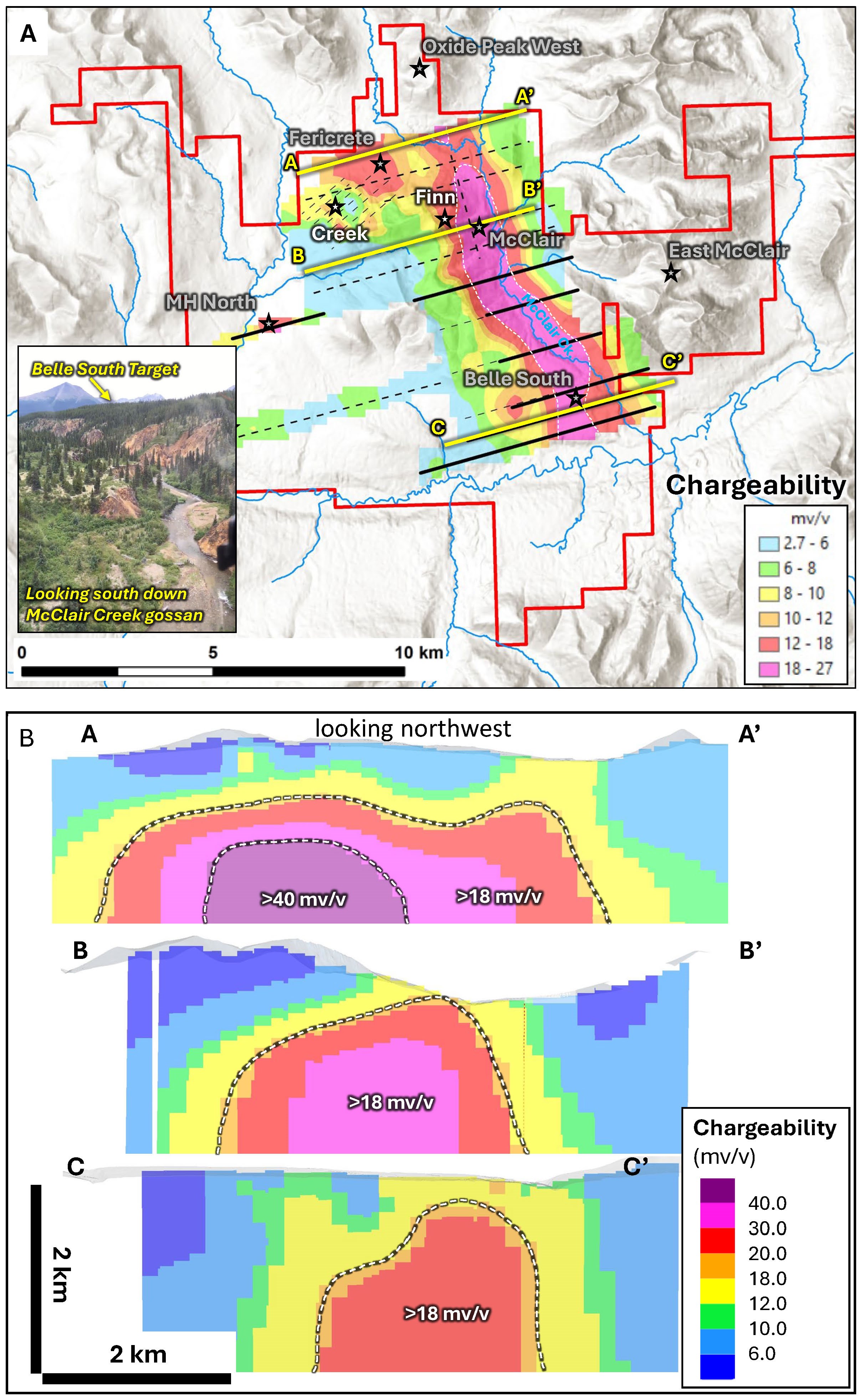
Figure 1. JD Porphyry Trend, A. Map of the JD Project showing the recently acquired and compiled IP data (400m depth slice through the chargeability model). New (black) and historical IP lines (dashed) shown. Key targets are highlighted. Inset photo looking south down McClair Creek showing parts of the 10 km long McClair Creek gossan. The Belle South porphyry target is situated above the gossan on a till covered plateau, where the coincident high-chargeability and high-magnetic intensity (Figure 2b) is located, B. Sections through the chargeability 3D voxel model showing the strong-chargeability anomaly at Fericrete (A-A'), McClair (B-B') and Belle South (C-C') targets. Section lines shown in (A).
To view an enhanced version of this graphic, please visit:
https://images.newsfilecorp.com/files/6142/266939_eff55888c4b95891_001full.jpg
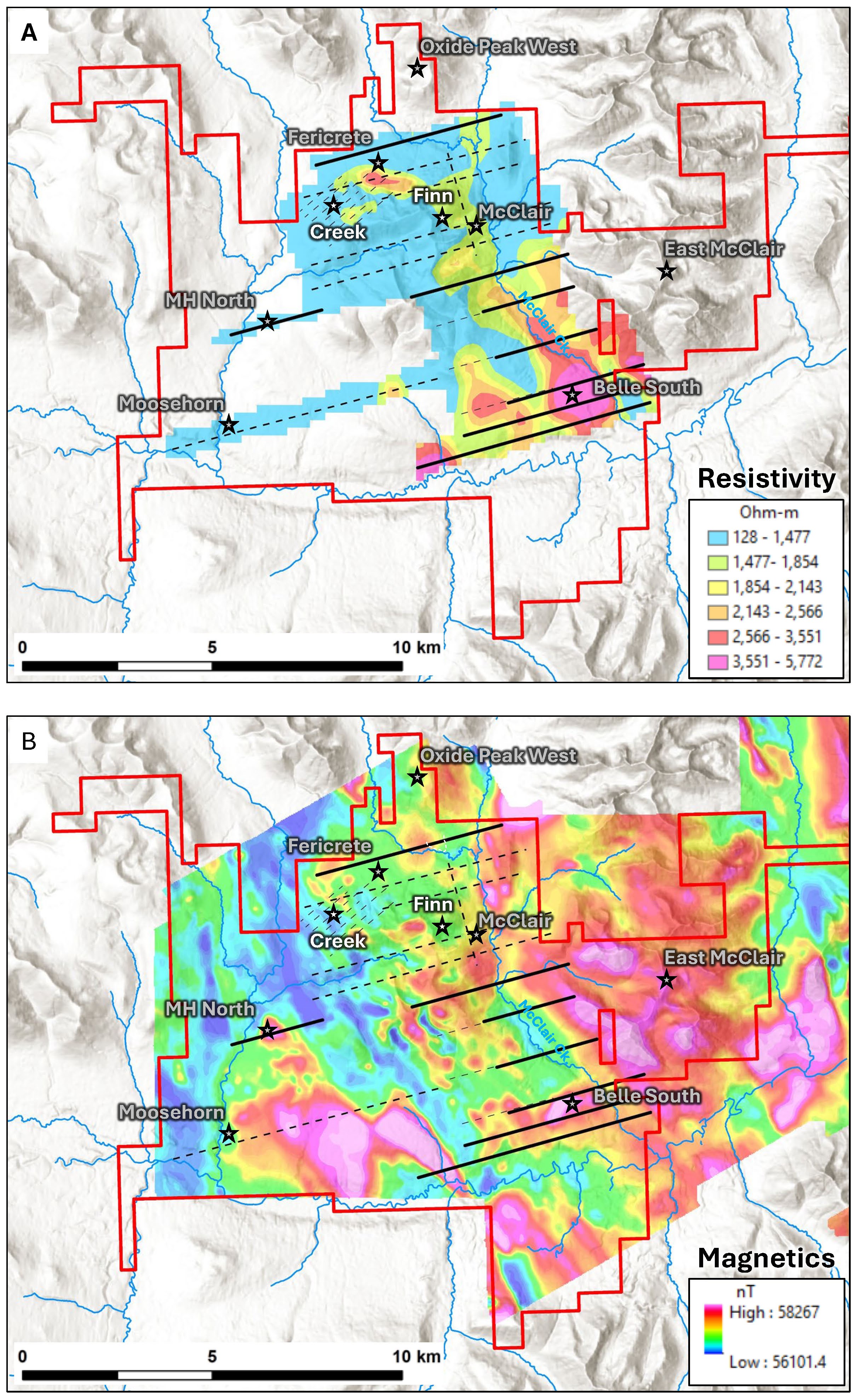
Figure 2. JD Porphyry Trend, A. Map of the JD Project showing the recently acquired and compiled IP data (400m depth slice through the resistivity model). New (black) and historical (dashed) IP lines shown, B. Map of the JD Project showing total magnetic intensity data acquired in 2021 overlain with IP lines and key target areas.
To view an enhanced version of this graphic, please visit:
https://images.newsfilecorp.com/files/6142/266939_eff55888c4b95891_002full.jpg
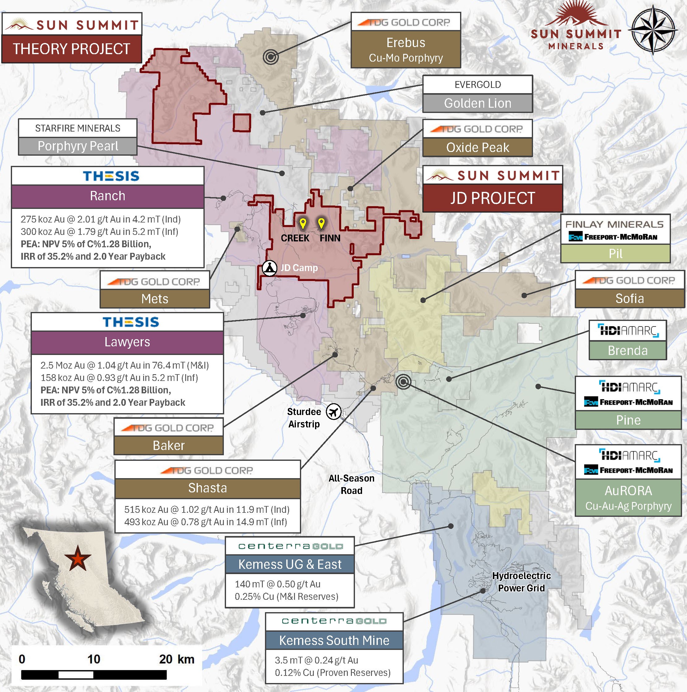
Figure 3. Map of the Toodoggone District showing the location of the JD Project in relation to other development and exploration projects. Data sourced from Thesis, TDG and Centerra's corporate websites. The QP has been unable to verify the information and that the information is not necessarily indicative to the mineralization on the property that is the subject of the disclosure.
To view an enhanced version of this graphic, please visit:
https://images.newsfilecorp.com/files/6142/266939_eff55888c4b95891_003full.jpg
National Instrument 43-101 Disclosure
This news release has been reviewed and approved by Sun Summit's Vice President Exploration, Ken MacDonald, P. Geo., a "Qualified Person" as defined in National Instrument 43-101 Standards of Disclosure for Mineral Projects of the Canadian Securities Administrators. Some technical information contained in this release is historical in nature and has been compiled from public sources believed to be accurate. The historical technical information has not been verified by Sun Summit and may in some instances be unverifiable dependent on the existence of historical drill core and grab samples.
Community Engagement
Sun Summit is engaging with First Nations on whose territory our projects are located and is discussing their interests and identifying contract and work opportunities, as well as opportunities to support community initiatives. The Company looks forward to continuing to work with local and regional First Nations with ongoing exploration.
About the JD Project
The JD Project is located in the Toodoggone mining district in north-central British Columbia, a highly prospective deposit-rich mineral trend. The project covers an area of over 15,000 hectares and is in close proximity to active exploration and development projects, such as Thesis Gold's Lawyers and Ranch projects, TDG Gold's Baker-Shasta projects, Amarc Resource's AuRORA project, Centerra's Gold's Kemess East and Underground projects, as well as the past-producing Kemess open pit copper-gold mine.
The project is 450 kilometres northwest of the city of Prince George, and 25 kilometres north of the Sturdee airstrip. It is proximal to existing infrastructure in place to support the past-producing Kemess mine, including roads and a hydroelectric power line.
The JD Project is in a favourable geological environment characterized by both high-grade epithermal gold and silver mineralization, as well as porphyry-related copper and gold mineralization. Some historical exploration, including drilling, geochemistry and geophysics, has been carried out on the property, however the project area is largely underexplored.
About Sun Summit
Sun Summit Minerals (TSXV: SMN) (OTCQB: SMREF) is a mineral exploration company focused on the discovery, expansion and advancement of district scale gold and copper assets in British Columbia. The Company's diverse portfolio includes the JD and Theory projects in the Toodoggone region of north-central B.C., and the Buck Project in central B.C.
Further details are available at www.sunsummitminerals.com.
References
- Greig, R., Steiner, A, Dudek, N., (2024), 2023 Joy Project Assessment Report, Omenica Mining Division, Assessment Report Indexing System, Report 41856, https://apps.nrs.gov.bc.ca/pub/aris.
Link to Figures
On behalf of the board of directors
Niel Marotta
Chief Executive Officer & Director
info@sunsummitminerals.com
For further information, contact:
Matthew Benedetto, Simone Capital
mbenedetto@simonecapital.ca
Tel. 416-817-1226
Forward-Looking Information
Statements contained in this news release that are not historical facts may be forward-looking statements, which involve risks, uncertainties and other factors that could cause actual results to differ materially from those expressed or implied by such forward-looking statements. In addition, the forward-looking statements require management to make assumptions and are subject to inherent risks and uncertainties. There is significant risk that the forward-looking statements will not prove to be accurate, that the management's assumptions may not be correct and that actual results may differ materially from such forward-looking statements. Accordingly, readers should not place undue reliance on the forward-looking statements. Generally forward-looking statements can be identified by the use of terminology such as "anticipate", "will", "expect", "may", "continue", "could", "estimate", "forecast", "plan", "potential" and similar expressions. Forward-looking statements contained in this press release may include, but are not limited to, the timing of and size and scope of the drill program at the JD property; indications and results from drilling may be materially different; the Company's exploration plans, expectations and forecasts. These forward-looking statements are based on a number of assumptions which may prove to be incorrect which, without limiting the generality of the following, include: the Company's ability to complete the drill program as currently contemplated; the anticipated results based on current indications; risks inherent in exploration activities; volatility and sensitivity to market prices; volatility and sensitivity to capital market fluctuations; and fluctuations in metal prices. The forward-looking statements contained in this news release are made as of the date hereof or the dates specifically referenced in this press release, where applicable. Except as required by applicable securities laws and regulation, Sun Summit disclaims any intention or obligation to update or revise any forward-looking statement, whether as a result of new information, future events or otherwise, except as required by applicable securities laws. All forward-looking statements contained in this press release are expressly qualified by this cautionary statement.
Neither the TSX Venture Exchange nor its Regulation Services Provider (as that term is defined in the policies of the TSX Venture Exchange) accepts responsibility for the adequacy or accuracy of this release.
![]()
To view the source version of this press release, please visit https://www.newsfilecorp.com/release/266939