
Western Star Drone Magnetics Trace the Skarn-Hosting Granite-Limestone Contact Beneath Cover at Eagle Point In Preparation For Drill Program
Sentiment and the balance of points
Rhea-AI Sentiment reads the wording of the document, how positive or negative its language is on a 1 to 5 scale. The balance of points shown with the takes weighs what the document actually discloses, so the two can disagree, for example when a trial that missed its main goal is described in upbeat language.
Rhea-AI Summary
Western Star Resources (WSRIF) completed a drone magnetic survey at Eagle Point, tracing an interpreted granite–limestone contact for approximately 3 kilometres. The survey covered approximately 4.9 km² at the 100%-owned New Mexico tungsten project. The company interprets the contact as the prospective zone for tungsten-bearing skarn, a rock formed where granite-related fluids react with limestone.
The interpretation is incorporated into the geological model and planned 17-hole, approximately 1,850-metre drill program. Six holes would test beneath cover up to approximately 400 metres north-west of historical workings. Assays from 23 samples collected in August 2026 remain pending and will help finalize targets. Mapping and sampling will extend north-west, while drilling logistics and applicable permitting advance. Magnetic surveys do not detect tungsten; drilling must confirm the interpretation.
How this balance works
Rhea-AI gives every point it takes from this document a weight. Minor counts 1, Moderate 3 and Major 9, so one Major point outweighs several Minor ones. The bar adds up the weights on each side, and when neither side holds more than 65% of the total the balance reads Mixed.
It reads the document as published, with the same rules for every company, and it does not look at what the market expected or at how the stock traded, so a point can be objectively good on a day the stock falls.
Rhea-AI Sentiment measures something else, the tone of the wording.
Hollow bars mark forward-looking points. How the balance works
Positive
- Moderate point. Forward-looking: it has not happened yet and may not happen.Planned 17-hole, approximately 1,850-metre program includes six holes stepping out up to approximately 400 metres north-west.
- Minor pointCompleted approximately 4.9 km² magnetic survey supports exploration at the wholly owned Eagle Point project.
- Minor pointInterpreted prospective contact extends approximately 3 kilometres, including beneath shallow cover.
- Minor pointHistorical workings and mapped mineralized skarn connect the magnetic interpretation to known scheelite mineralization.
- Minor point. Forward-looking: it has not happened yet and may not happen.Planned north-west mapping and sampling will extend along the interpreted contact, including historical trenches.
Negative
- Minor pointMagnetic interpretation requires drilling confirmation; the survey does not detect tungsten.
- Minor point. Forward-looking: it has not happened yet and may not happen.Assays from 23 August 2026 samples remain pending and will inform final drill targets.
- Minor point. Forward-looking: it has not happened yet and may not happen.Proposed drilling still requires advancement of applicable permitting and logistics.
Details
News Market Reaction – WSRIF
On Nov 11, the day this news came out, WSRIF closed 2.99% below the previous close.
Data tracked by StockTitan Argus for the Nov 11 session.
AI-generated analysis. How Rhea-AI works. Not financial advice.


Vancouver, British Columbia – November 11, 2026 – TheNewswire - Western Star Resources Inc. (CSE: WSR) (OTC: WSRIF) (FRA: 4K2) (the “Company” or “Western Star”) is pleased to announce the results of the high-resolution drone magnetic survey at its
Blake Morgan, the CEO and President of Western Star, stated “The drone survey has done exactly what we needed it to do at Eagle Point. The skarn we mapped in August sits on the granite–limestone contact, but most of that contact is hidden under shallow cover. The magnetics now show us where it goes, and it runs for kilometres north-west beneath the cover. With the contact mapped and the 3D model updated, we are going into the maiden drill program with a much clearer picture of where to put the holes.”
Key Highlights:
• A high-resolution drone magnetic survey covering approximately 4.9 km² has been completed over the southern and western parts of the Eagle Point claims. Processing and interpretation were completed by Warren Hughes, P.Geo., of East Coast Consulting.
• A broad, arcuate magnetic high, bounded to the north-west by a sharp gradient against a magnetically quiet domain, is interpreted to reflect the granite, with the quiet domain corresponding to the Horquilla Limestone. The gradient between them is interpreted to approximate the skarn-hosting granite–limestone contact.
• The interpreted contact is traced for approximately 3 kilometres, curving from the north-eastern part of the survey south-west across the western part of the Property, where it projects beneath shallow cover and cannot be mapped at surface.
• The historical Eagle Point workings and the principal skarn exposure sampled by the Company in August 2026 sit at the southern end of the interpreted contact, providing a direct link between the magnetic framework and known scheelite mineralization.
• The planned 17-hole, approximately 1,850-metre (6,070-foot) drill program has been positioned on the interpreted contact. Six holes step out up to approximately 400 metres north-west of the historical workings to test the contact beneath talus cover.
• Assay results from the 23 samples collected in August 2026 remain pending and will be integrated with the magnetics and the three-dimensional model to finalize drill targets.
Click Image To View Full Size
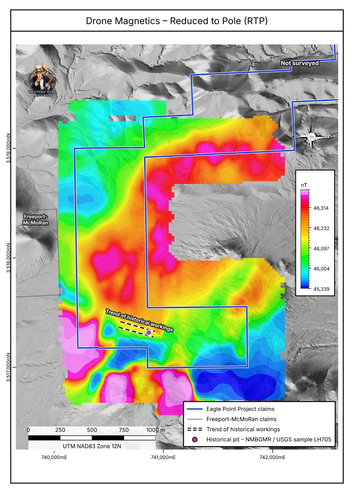
Figure 1: Reduced-to-pole (RTP) total magnetic intensity from the 2026 drone magnetic survey. The Eagle Point claim boundary, the trend of the historical workings and the historical pit from which sample LH705 was collected are shown. The north-eastern claims were not surveyed. Grid UTM NAD83 Zone 12N.
The Tungsten Skarn Setting at Eagle Point
Tungsten skarns form where a granitic intrusion is emplaced into a carbonate sequence. Hydrothermal fluid expelled from the cooling intrusion reacts with the limestone to produce garnet-rich calc-silicate rock (skarn or tactite), and it is within that skarn that scheelite, the principal tungsten mineral, is deposited. The contact between the intrusion and the carbonate host is therefore the primary exploration target.
At Eagle Point, mapping by the Company in August 2026 identified scheelite-bearing skarn developed along the contact between intrusive granite and Horquilla Limestone, with scheelite associated with garnet, epidote and lesser quartz (see news release dated September 22, 2026). The exposed contact dips steeply, at approximately 80 degrees, but extensive talus cover obscures much of it, and its full extent and geometry cannot be established from surface mapping alone. Mapping that contact beneath cover was the principal objective of the drone survey.
Mapping the Contact Beneath Cover
The magnetic data show a broad, arcuate magnetic high that trends east–west across the northern part of the survey, curves south-west across the western part of the Property and continues into the southern part of the Property. To the north-west it is bounded by a sharp magnetic gradient against a magnetically quiet domain. The quiet domain corresponds to the limestone mapped north and west of the granite, and the high to the granite and its margin. The Company interprets the gradient to approximate the granite–limestone contact.
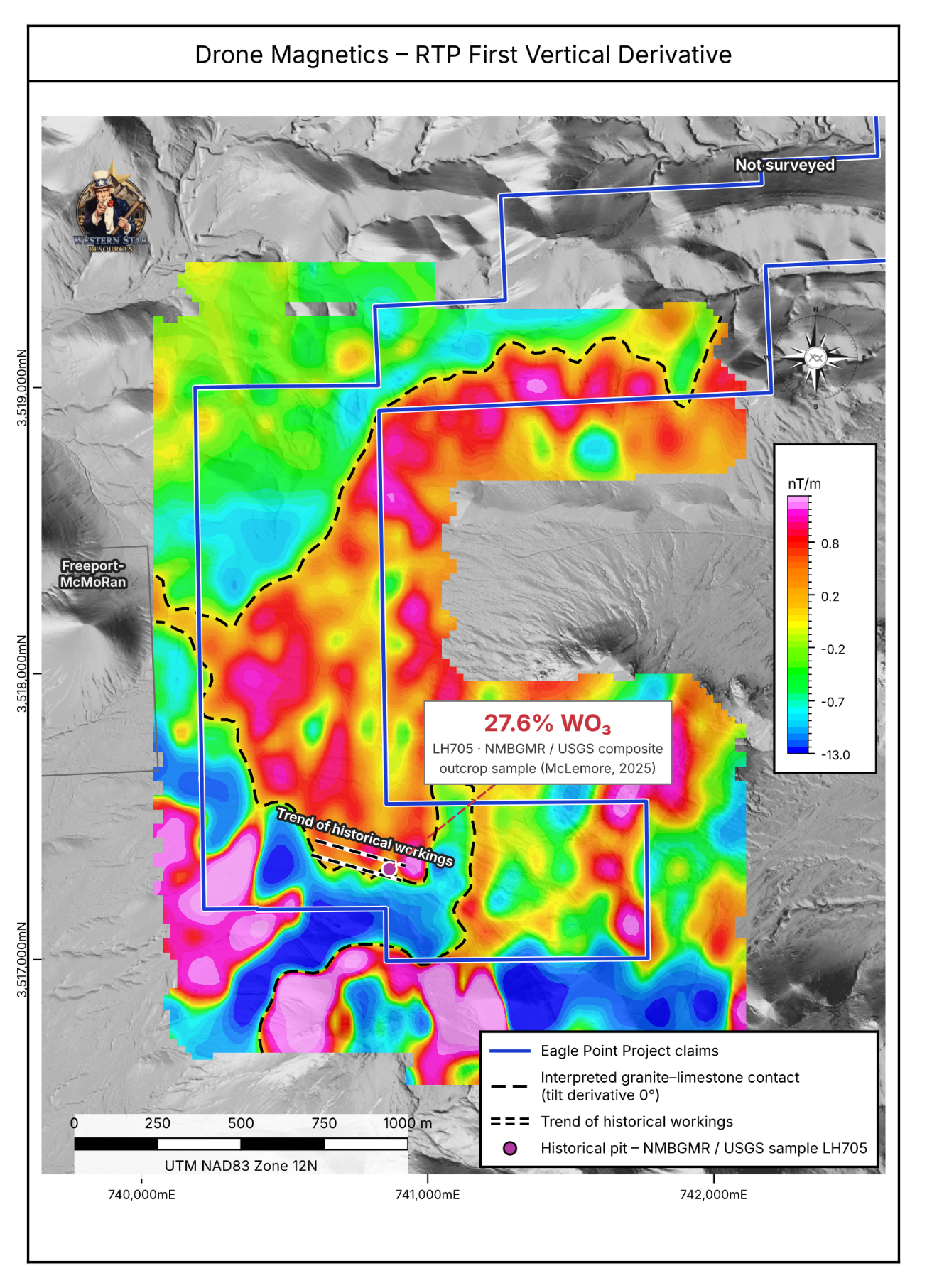
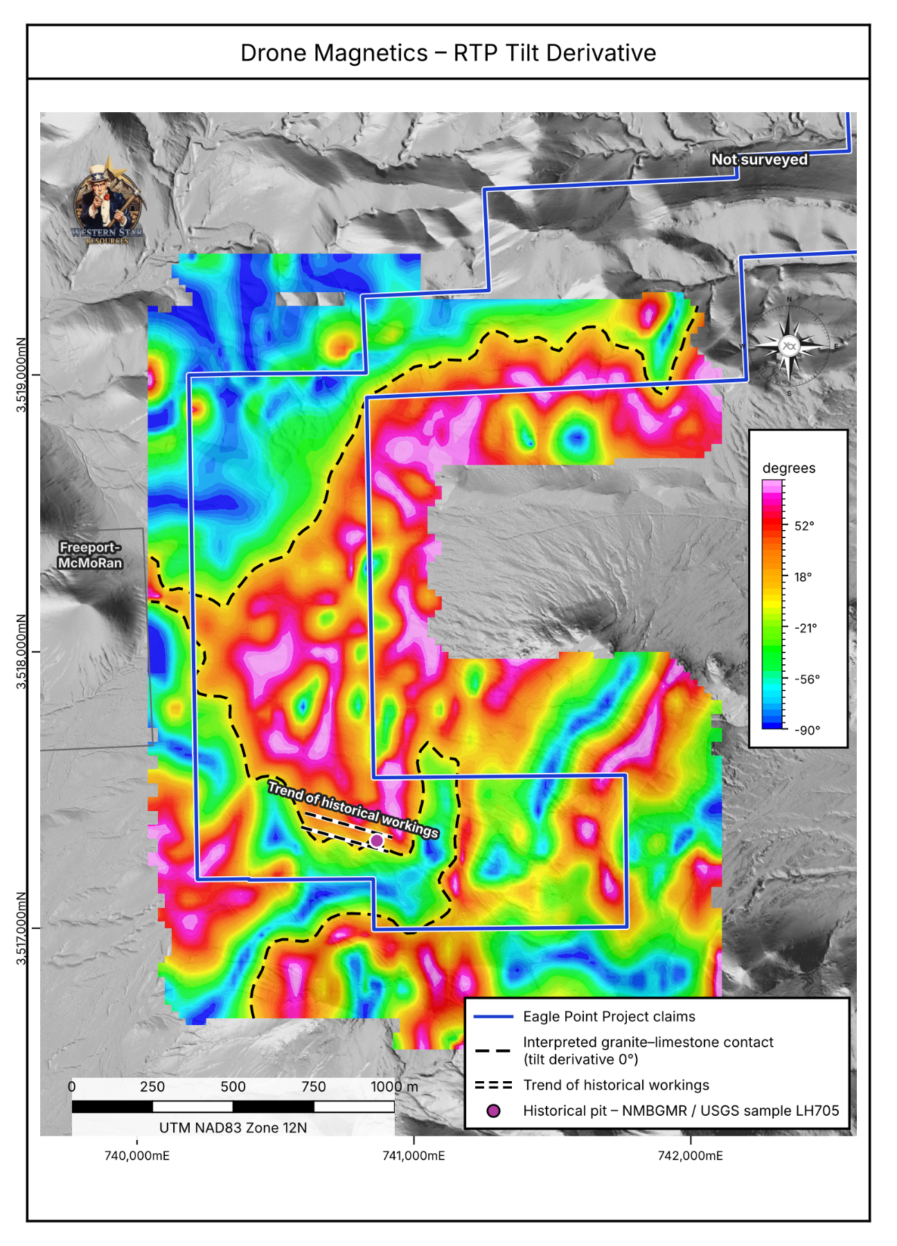
On this interpretation, the contact is traced for approximately 3 kilometres through the surveyed area, including across the western part of the Property, where it projects beneath shallow cover. The historical trenches in the western part of the Property (Trenches 4 to 7 and 9; see news release dated September 15, 2026) lie in the same contact zone and have not previously been followed up with modern exploration.
The historical Eagle Point workings, the garnet-skarn contact mapped by the Company in August 2026 and the twelve samples (LH700–LH711) collected by the New Mexico Bureau of Geology and Mineral Resources sit at the southern end of the interpreted contact, where it bends sharply to the east. This links the magnetic framework directly to the known scheelite mineralization on the Property and gives the Company a basis for following the contact away from the exposed skarn.
Strong, discrete magnetic highs along the southern edge of the survey lie largely south of the Company’s claims and at the edge of the survey, where the data are least constrained, and are not interpreted further at this stage.
Click Image To View Full Size
Figure 2: RTP first vertical derivative with the interpreted granite–limestone contact (tilt derivative zero contour). Sample LH705 (
Click Image To View Full Size
Figure 3: Tilt derivative of the RTP magnetic field. The zero contour (dashed) marks the interpreted edges of the magnetic sources, interpreted as the granite–limestone contact. Grid UTM NAD83 Zone 12N.
Integration with the Planned Drill Program
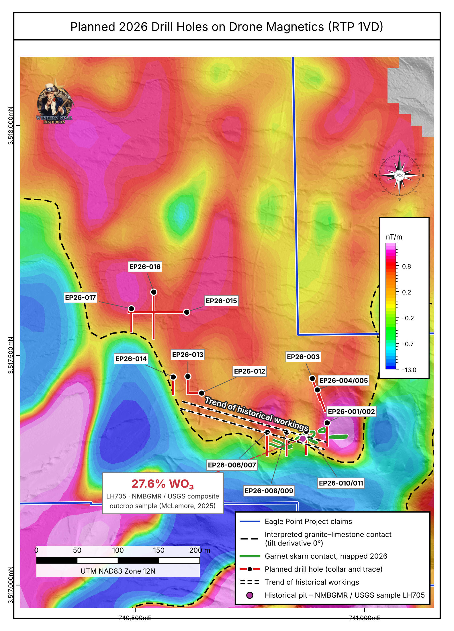
The magnetic interpretation has been incorporated into the Company’s three-dimensional Leapfrog Geo model, which supports the planned 17-hole, approximately 1,850-metre (6,070-foot) drill program announced on September 22, 2026. The holes are designed as shallow, closely spaced tests of the steeply dipping skarn contact and are positioned along the interpreted magnetic contact (Figure 4):
Click Image To View Full Size
Figure 4: Planned 2026 drill holes (collars and surface traces of hole paths) on the RTP first vertical derivative, with the interpreted granite–limestone contact and the garnet-skarn contact mapped by the Company in August 2026. Grid UTM NAD83 Zone 12N.
Next Steps
Assay results from the 23 samples collected from the principal skarn target in August 2026 are pending at ALS Geochemistry in Tucson, Arizona. These will be integrated with the magnetic interpretation, the geological mapping and the three-dimensional model to finalize drill targets. Mapping and sampling will be extended north-west along the interpreted contact, including the historical trenches, and the Company is advancing drilling logistics and applicable permitting for the proposed program.
Qualified Person
The scientific and technical information contained in this news release has been reviewed and approved by Jasper Mowatt, MIMMM, MAusIMM, a consultant to the Company and a Qualified Person as defined by National Instrument 43-101 – Standards of Disclosure for Mineral Projects. Mr. Mowatt is not independent of the Company.
Quality Assurance and Quality Control (QA/QC):
The UAV magnetic survey was flown by AJ Mining LLC using a DJI Matrice M300 platform carrying a GSMP-35U potassium vapour magnetometer, at a nominal sensor height of 30 metres with terrain following. Flight lines were oriented east-west at 100 metre spacing with tie lines at 1000 metres over approximately 4.9 km² (1,200 acres). Data were quality-checked in the field and corrected against base-station readings, with diurnal, lag and heading corrections applied. Processing, levelling, gridding and interpretation were completed by Warren Hughes, P.Geo., of East Coast Consulting using Geosoft Oasis Montaj, with data gridded at a 25-metre cell size. Reduction to the pole (inclination 58.5°, declination 8.2°), tilt derivative and related products were computed from the levelled total magnetic intensity grid. All coordinates are reported in the NAD83 UTM Zone 12N coordinate system. Magnetic surveys measure a physical rock property and do not detect tungsten; scheelite is not magnetic, and the interpretations described in this news release require confirmation by drilling. Sample LH705 and the LH700–LH711 suite were not collected by or under the supervision of the Company, and the Qualified Person has not verified the sampling or analytical procedures.
References
McLemore, V.T., 2025. Master chemical database of critical mineral deposits in New Mexico (unpublished compilation dated 18 September 2025). New Mexico Bureau of Geology and Mineral Resources. Samples LH700–LH711; analysed by the U.S. Geological Survey, laboratory file MRP-21541. WO₃ calculated from W using a factor of 1.2611.
About Western Star Resources
Western Star Resources is a mineral exploration company focused on the acquisition, exploration and advancement of mineral properties, with a growing strategic emphasis on tungsten and critical minerals in the United States. The Company is advancing a portfolio of past-producing tungsten assets in Nevada and New Mexico, including the Eagle Point Tungsten Project in New Mexico and the Rowland and White Star tungsten projects in Nevada, while maintaining additional exploration exposure through its Western Star Property in British Columbia.
Contact Information:
Blake Morgan,
Director, President and CEO
blake@acvc.vc
Phone: 236-878-4938
Neither the Canadian Securities Exchange nor its Regulation Services Provider (as that term is defined in the policies of the Canadian Securities Exchange) accepts responsibility for the adequacy or accuracy of this press release.
Certain of the statements made and information contained herein may constitute “forward-looking information”. In particular, references to the interpretation of the magnetic survey, the planned drill program and its permitting, pending assay results, and future work programs or expectations on the quality or results of such work programs are subject to risks associated with operations on the property, exploration activity generally, the inherent uncertainty of geophysical interpretation, equipment limitations and availability, as well as other risks that we may not be currently aware of. Accordingly, readers are advised not to place undue reliance on forward-looking information. Except as required under applicable securities legislation, the Company undertakes no obligation to publicly update or revise forward-looking information, whether as a result of new information, future events or otherwise.
Copyright (c) 2026 TheNewswire - All rights reserved.
FAQ
AI-generated questions and answers. How Rhea-AI works. Not financial advice.