
Bentley Systems Announces Seequent’s Acquisition of Seismic Interpretation Software Company Eliis
Eliis brings PaleoScan, a seismic interpretation platform used by hundreds of energy companies, into Seequent’s portfolio.
Sentiment and the balance of points
Rhea-AI Sentiment reads the wording of the document, how positive or negative its language is on a 1 to 5 scale. The balance of points shown with the takes weighs what the document actually discloses, so the two can disagree, for example when a trial that missed its main goal is described in upbeat language.


Strengthens Seequent’s subsurface software portfolio, energy and geophysics capabilities, and expands team of specialists
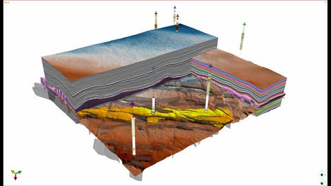
3D view from PaleoScan showcasing recent advancements in seismic interpretation workflows that support prospect evaluation and exploration decision-making
Founded in 2007 and with headquarters in Montpellier,
Eliis’ software includes seismic interpretation platform PaleoScan, with its patented Relative Geological Time technology and AI-assisted interpretation capabilities, that is used by hundreds of energy companies, and groundbreaking industry co-innovation project PaleoModel to enable downstream reservoir simulation. Eliis’ seismic interpretation capabilities complement Seequent’s subsurface portfolio including its implicit modeling tool Leapfrog.
Graham Grant, CEO, Seequent, said, “I am delighted to welcome Eliis to Seequent. Global challenges—notably energy security, the energy transition, and the demand for critical resources—are increasing the need for deeper subsurface insight. Lower cost seismic data acquisition and AI are expanding the adoption of seismic methods beyond oil and gas. We see huge opportunity in energy, mining, as well as groundwater management, the recovery of minerals from brines, and carbon storage. For example, seismic interpretation helps mining companies reduce geological uncertainty and discover deeper mineral deposits compared to traditional methods. Eliis will strengthen Seequent’s ability to help our users understand the underground, reduce uncertainty and risk, and make better, faster, and more confident decisions.”
Benoît Matha, CEO, Eliis, said, “Seequent’s acquisition of Eliis provides us with a secure, long-term home in a company that deeply understands and values our expertise and software. The combination of Eliis’ seismic expertise with complementary geoscience and reservoir technologies will accelerate our ambition to become a leading subsurface technology platform beyond the energy industry —extending our reach across the subsurface workflow and unlocking new growth opportunities. We are excited to join Seequent and by the opportunities ahead.”
Dechert LLP and Simmons & Simmons LLP acted as legal advisors to Bentley and Seequent in the transaction.
###
For high-resolution images, click here.
About Bentley Systems
Around the world, infrastructure professionals rely on software from Bentley Systems to help them design, build, and operate better and more resilient infrastructure for transportation, water, energy, cities, and more. Founded in 1984 by engineers for engineers, Bentley is the partner of choice for engineering firms and owner-operators worldwide, with software that spans engineering disciplines, industry sectors, and all phases of the infrastructure lifecycle. Through our digital twin solutions, we help infrastructure professionals unlock the value of their data to transform project delivery and asset performance.
About Seequent
Seequent, The Bentley Subsurface Company, helps organisations to understand the underground, giving them the confidence to make better decisions faster. Seequent builds world-leading technology that is at the forefront of Earth sciences, transforming the way our customers work. Every day we help them develop critical mineral resources more sustainably, design and build better infrastructure, source renewable energy, and reduce their impact on the environment.
Seequent operates in 150+ countries while proudly maintaining headquarters in New Zealand. Once Eliis joins the company, we will be 950+ colleagues strong in 32 locations.
© 2026 Bentley Systems, Incorporated. Bentley, the Bentley logo, Eliis, Leapfrog, PaleoModel, PaleoScan and Seequent are either registered or unregistered trademarks or service marks of Bentley Systems, Incorporated or one of its direct or indirect wholly owned subsidiaries. All other brands and product names are trademarks of their respective owners.
View source version on businesswire.com: https://www.businesswire.com/news/home/20261029964674/en/
For more information, contact:
Press Contact: Liz Crawshaw, liz.crawshaw@seequent.com, +64 21 501 036
Bentley investors: Eric Boyer, IR@bentley.com
Newsroom: https://www.seequent.com/company/news-media/
Seequent on LinkedIn.
Source: Bentley Systems, Incorporated