
Canuc Launches Major Airborne Gravity Survey, Targeting Deep Discovery Potential at East Sudbury Project
Sentiment and the balance of points
Rhea-AI Sentiment reads the wording of the document, how positive or negative its language is on a 1 to 5 scale. The balance of points shown with the takes weighs what the document actually discloses, so the two can disagree, for example when a trial that missed its main goal is described in upbeat language.
Rhea-AI Summary
Canuc Resources (OTCQB: CNUCF) has commenced a major airborne Full Tensor Gravity Gradiometer (FTG), magnetic and LiDAR survey, flown by Bell Geospace, over its 100% owned East Sudbury Project (ESP) in Ontario, covering a ~200 km2 land package and nearly 2,000 line-kilometres.
According to Canuc, the program will map deep geological structures, refine understanding of the McLaren Lake Fault and parallel faults, and integrate FTG results with seismic, historical drilling, past-producing gold and copper mines and AI-driven analysis to prioritize high-value gravity anomalies and large-scale drill targets, including potential IOCG-style deposits at depth.
Positive
- FTG, magnetic and LiDAR survey over nearly 2,000 line-km at ESP
- Covers ~200 km2 of 100% owned East Sudbury Project ground
- Integrates FTG, seismic, historical data and AI for drill targeting
- ESP land package totals 20,078 hectares near Sudbury Mining Camp
- Additional exposure via San Javier silver-gold project in Mexico
- Ongoing cash flow from MidTex natural gas and 4% Scadding NSR
Negative
- None.
AI-generated analysis. How Rhea-AI works. Not financial advice.




Toronto, Ontario--(Newsfile Corp. - August 18, 2026) - Canuc Resources Corporation (TSXV: CDA) (OTCQB: CNUCF) (WKN: A41V6H) ("Canuc" or the "Company") is pleased to announce that Bell Geospace has officially begun flying the Gravity Gradiometer, Magnetic and LiDAR Survey on Canuc's
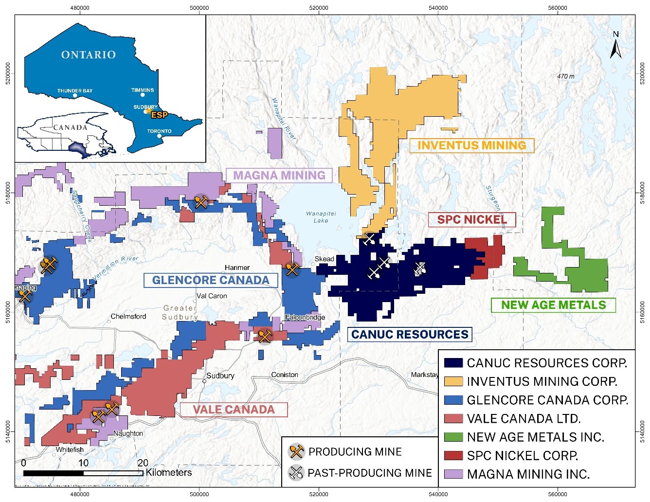
Figure 1. Canuc's East Sudbury Project (ESP) Regional Setting
To view an enhanced version of this graphic, please visit:
https://images.newsfilecorp.com/files/2906/309939_2d85443614e5fb7b_001full.jpg
A Powerful New Exploration Tool Across Nearly 2,000 Line-Kilometers
The comprehensive survey program will cover close to 2,000-line kilometres giving Canuc one of the most detailed subsurface pictures ever compiled on the ESP. (Figure 2 below).
Bell's cutting-edge Full Tensor Gradiometer ("FTG") and magnetic data will be used to map deep geological structures and help to identify large-scale drill targets across the entire East Sudbury Project - unlocking terrain not previously explored in such detail at depth. The program is designed to sharpen the Company's understanding of the McLaren Lake Fault and three sub-parallel faults already identified on the property, while also helping to uncover previously unmapped sub-surface structures.
The FTG survey builds directly on the seismic program completed last month (July, 2026) by OptiSeis Solutions Ltd. and Natural Resources Canada along the McLaren Lake Fault. Together, these two leading-edge geophysical programs are expected to significantly improve geological interpretation and enhance the identification and targeting of prospective mineralized systems, including MIAC related gold and IOCG-style deposits.
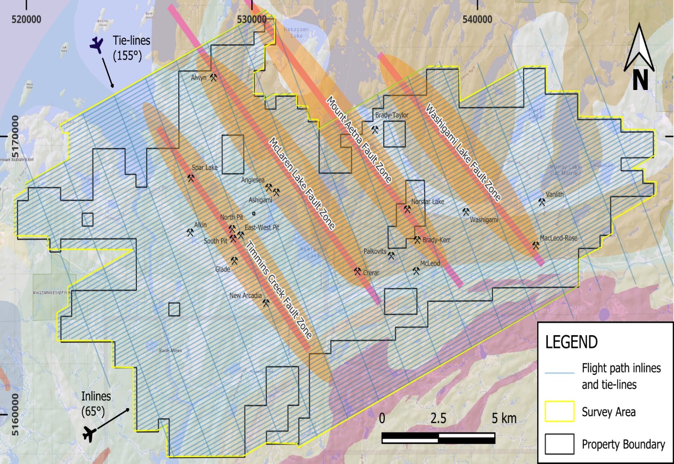
Figure 2. Flight Lines for Full Tensor Gravity Gradiometer, Magnetic, and LIDAR Survey
To view an enhanced version of this graphic, please visit:
https://images.newsfilecorp.com/files/2906/309939_2d85443614e5fb7b_002full.jpg
Gravity Gradiometer Survey Deliverables
Bell's Full Tensor Gradiometer (FTG), magnetic data and enhanced interpretation products will be used to identify and prioritize high-value gravity anomalies for follow up drilling on the East Sudbury Project.
Canuc plans to integrate these results with historical regional geological data, the locations of past producing gold and copper mines and occurrences, and the recently completed seismic survey, to compile a rich, comprehensive data set for AI-driven analysis to further refine exploration targeting.
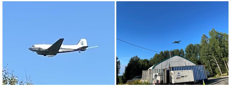
Figure 3. BellGeo DC3 Flying FT Gravity, Magnetic, and LIDAR Survey 17.Aug.2026
To view an enhanced version of this graphic, please visit:
https://images.newsfilecorp.com/files/2906/309939_8ee4774c54d20ae3_001full.jpg
Program Objectives
"Despite a history of high-grade gold and copper mining dating back as far as 1904, and despite nearly 45,000 metres of historical drilling around old gold and copper mine workings, effectively no drilling or exploration has been undertaken beyond 150 metres of depth on the claims covered by Canuc's East Sudbury Project," stated Christopher Berlet, CEO and Director of Canuc.
"These new gravity and seismic exploration tools, combined with enhanced AI-driven analysis will allow us - for the first time - to look beyond the near surface expressions of these historic gold and copper mine workings as we search for larger source deposit models or feeder systems and potentially IOCG type deposits at depth."
"Our objective is to deliver a transformational regional exploration outcome east of the Sudbury Basin, one of Canada's most storied and successful mining jurisdictions."
Canuc's updated website and corporate presentation can be found at: www.canucresources.ca
The technical information in this release has been reviewed and approved by Seymour Sears, B.A., B.Sc., P.Geo, a non-independent qualified person as defined by NI 43-101, who is currently managing exploration activity on the ESP Project.
About Canuc Resources Corporation
Canuc Resources Corporation is a junior resource company advancing its
Canuc also holds a
Canuc generates steady cash flow from natural gas production at its MidTex Energy Project in Central West Texas, USA where the Company holds interests in producing natural gas wells and has rights for further infield development. The Company also receives a
For further information please visit: www.canucresources.ca
Christopher J. Berlet B.A.Sc.(Mining), CFA, CEO & Director of Canuc, is responsible for the content of this press release.
For further information please contact:
Canuc Resources Corporation
(416) 525 - 6869
cberlet@canucresources.ca
Forward Looking Information
This news release contains forward-looking information. All information, other than information of historical fact, constitute "forward-looking statements" and includes any information that addresses activities, events or developments that the Corporation believes, expects or anticipates will or may occur in the future including the Corporation's strategy, plans or future financial or operating performance.
When used in this news release, the words "estimate", "project", "anticipate", "expect", "intend", "believe", "hope", "may" and similar expressions, as well as "will", "shall" and other indications of future tense, are intended to identify forward-looking information. The forward-looking information is based on current expectations and applies only as of the date on which they were made. The factors that could cause actual results to differ materially from those indicated in such forward-looking information include, but are not limited to, the ability of the Corporation to fund the exploration expenditures required under the Agreement. Other factors such as uncertainties regarding government regulations could also affect the results. Other risks may be set out in the Corporation's annual financial statements, MD&A and other publicly filed documents.
The Corporation cautions that there can be no assurance that forward-looking information will prove to be accurate, as actual results and future events could differ materially from those anticipated in such information. Accordingly, investors should not place undue reliance on forward-looking information. Except as required by law, the Corporation does not assume any obligation to release publicly any revisions to forward-looking information contained in this press release to reflect events or circumstances after the date hereof.
Neither the TSXV nor its Regulation Services Provider (as that term is defined in the policies of the TSXV) accepts responsibility for the adequacy or accuracy of this news release.

To view the source version of this press release, please visit https://www.newsfilecorp.com/release/309939
FAQ
AI-generated questions and answers. How Rhea-AI works. Not financial advice.