CanAlaska Begins Ground-Based Geophysical Program at Waterbury South Project
Rhea-AI Summary
CanAlaska (OTCQX: CVVUF) has begun a 2026 ground-based geophysical program at its 100% owned Waterbury South project, ~10 km southeast of Cigar Lake and ~2 km from the Cigar Lake haul road.
The program uses an eight-line Stepwise Moving Loop TDEM survey (~90 km) to refine conductive corridors and generate drill targets; work is expected complete by early April 2026. Historic hole WAT009 returned polymetallic mineralization including 405 ppm U and 2.42% Ni over 0.5 m.
AI-generated analysis. How Rhea-AI works. Not financial advice.
Positive
- 90 km SWML-TDEM survey planned to refine targets
- Project is 100% CanAlaska and near Cigar Lake (10 km)
- WAT009 polymetallic intercept: 405 ppm U, 2.42% Ni over 0.5 m
- Survey completion anticipated by early April 2026
Negative
- Historical drill intercepts are narrow and limited in scope
- Historical results on file are unverified by a Qualified Person
News Market Reaction – CVVUF
On the day this news was published, CVVUF gained 10.98%, reflecting a significant positive market reaction.
Data tracked by StockTitan Argus on the day of publication.
Electromagnetic Survey Focused on Generating New Priority Drill Targets
Project Located 10 Kilometers from Cigar Lake Mine; 2 Kilometers from Cigar Lake Haul Road
Saskatoon, Saskatchewan--(Newsfile Corp. - February 19, 2026) - CanAlaska Uranium Ltd. (TSXV: CVV) (OTCQX: CVVUF) (FSE: DH7) ("CanAlaska" or the "Company") is pleased to announce the start of the 2026 ground-based geophysical program on the Waterbury South project (the "Project") in the eastern Athabasca Basin (Figure 1). The goal of the Waterbury South geophysical survey is to refine conductive corridors to generate targets for future drilling programs focused around historical mineralization on the Project. The Waterbury South project is
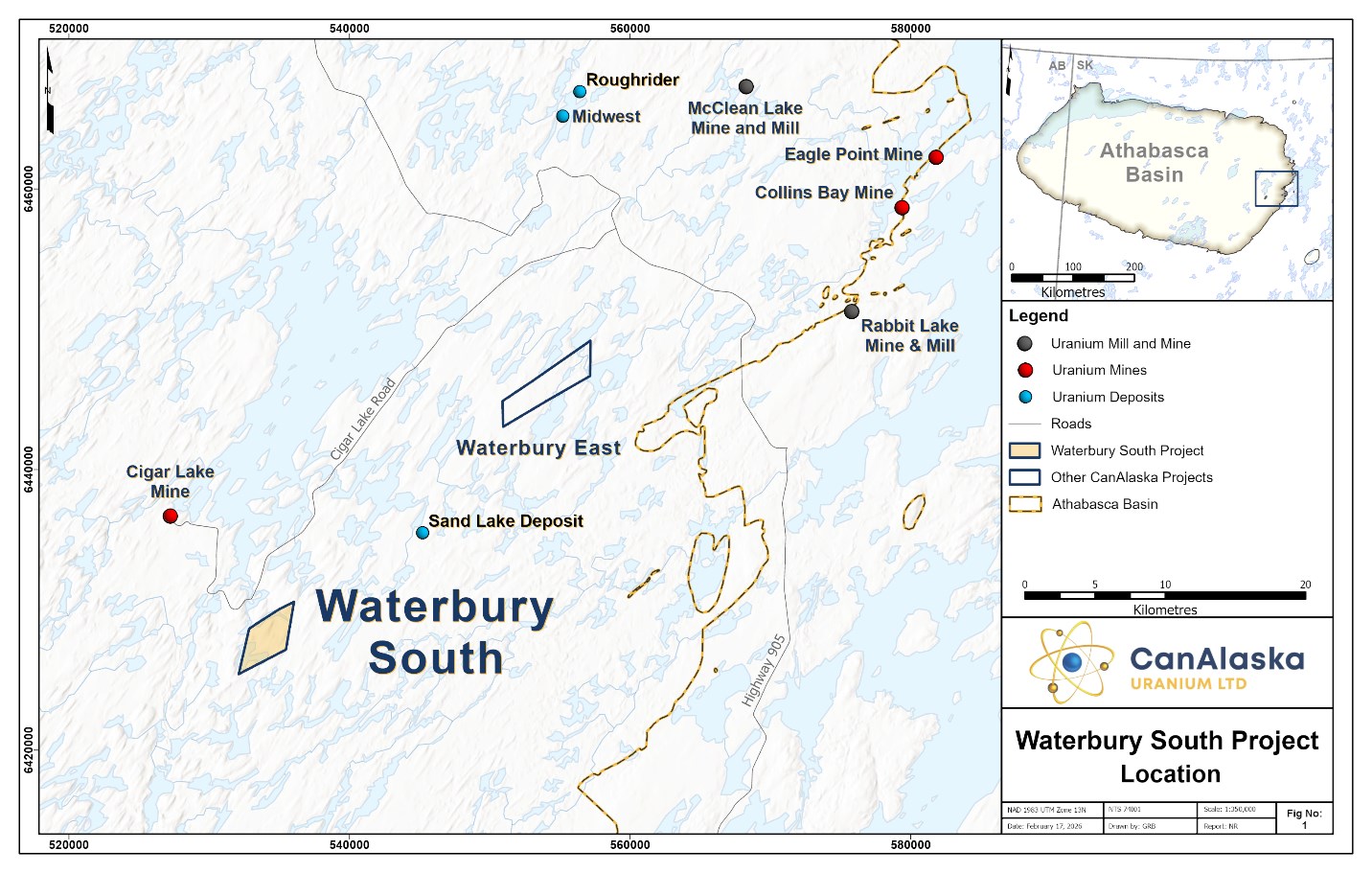
Figure 1 – Location of Waterbury South Project
To view an enhanced version of this graphic, please visit:
https://images.newsfilecorp.com/files/2864/284418_486af2bc24dad809_002full.jpg
CanAlaska CEO, Cory Belyk, comments, "The Waterbury South project has been sitting in our opportunity list for a few years as we advanced the West McArthur Pike Zone discovery. CanAlaska now has access to lower-cost capital to move this project toward discovery by following up on these very significant results from our recent drill programs in 2021 and 2022. The style and strength of polymetallic mineralization in WAT009 is directly relatable to the style of mineralization encountered at the nearby giant Cigar Lake uranium mine. Further discovery of uranium mineralization on this project has been hampered by not having new geophysical data to support drilling. The CanAlaska team is going to correct this through completion of this work in 2026. With Cigar Lake reaching its natural production life end-point in 2036, now is a great time to advance this project for our shareholders."
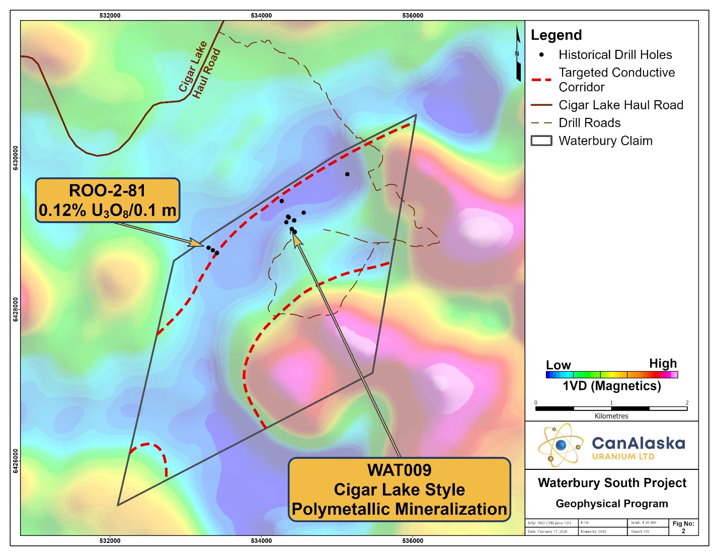
Figure 2 – Waterbury South Geophysical Program Focus
To view an enhanced version of this graphic, please visit:
https://images.newsfilecorp.com/files/2864/284418_486af2bc24dad809_004full.jpg
2026 Waterbury South Ground Geophysical Program
The winter 2026 exploration program on the Waterbury South project will consist of a ground-based electromagnetic survey to map the conductive corridors on the Project. A modern Stepwise Moving Loop Time Domain Electromagnetic survey (SWML-TDEM) is planned to advance the Project. The survey will consist of eight geophysical grid lines oriented perpendicular to a linear magnetic low corridor on the Project designed to map the location of the graphitic basement conductors where they intersect the sandstone and basement unconformity (Figure 2). The survey will consist of approximately 90 km of SWML-TDEM surveying utilizing the Volterra-EM acquisition system. The Volterra-EM acquisition system is a full-waveform,
The Waterbury South project is located along the regional prolific Collins Bay fault system which is interpreted to run from northeast of Cameco's Eagle Point Mine through the Eagle Point, Collins Bay, and Rabbit Lake uranium deposits and into the Project area. The Project has been subject to limited historical exploration by SMDC, Noranda, COGEMA, and Cameco who performed a variety of geochemical surveys, and airborne and ground based geophysical surveys. In the 1980's, Noranda completed one drill fence on the project, which identified basement-hosted uranium mineralization grading
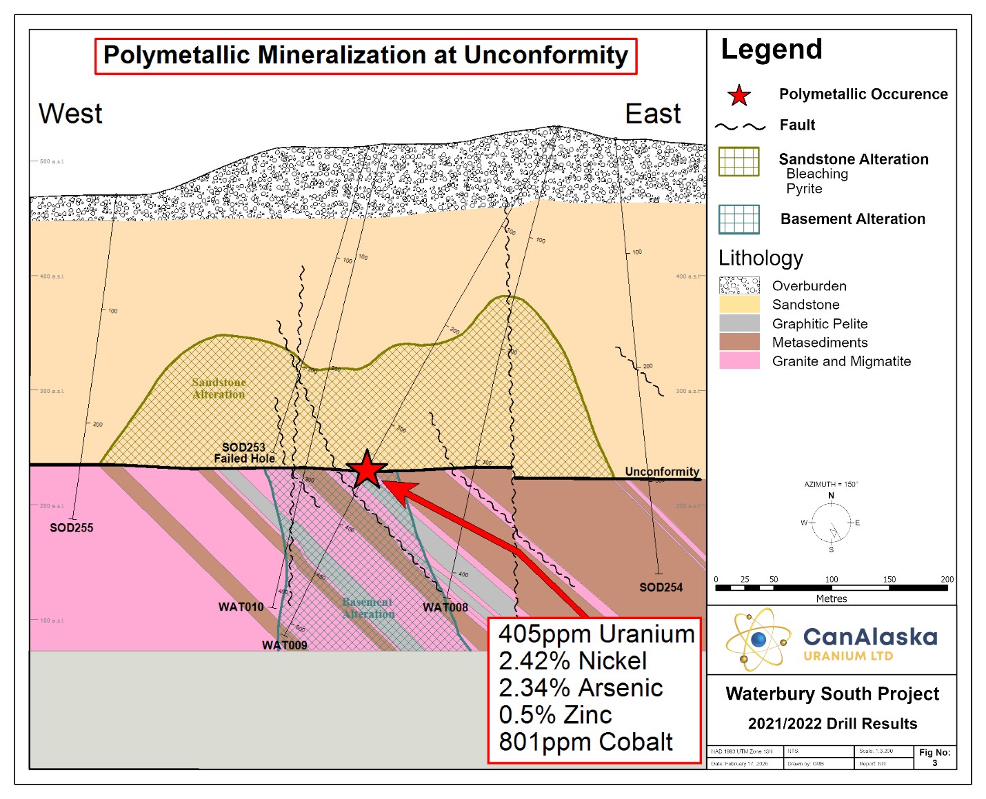
Figure 3 – Waterbury South 2021/2022 Drill Program Results
To view an enhanced version of this graphic, please visit:
https://images.newsfilecorp.com/files/2864/284418_486af2bc24dad809_006full.jpg
The Company acquired the Project in the mid-2000's and completed an airborne electromagnetic survey followed by a DC Resistivity survey that identified likely sandstone resistivity low breaches, a typical response for post-Athabasca structure and alteration on other projects in the area. In 2021, CanAlaska completed three drillholes on the Waterbury South project. This drill program was highlighted by WAT009 which intersected a strongly altered lower sandstone column with bleaching, sooty pyrite, desilicification, and chlorite, associated with polymetallic mineralization at the unconformity. The polymetallic mineralization is characterized by 0.5 m with 405 ppm uranium,
The 2026 winter exploration program is focused on mapping and refining conductive corridors on the Project, specifically targeting the strike extension of the historical mineralization and geochemical anomalism that was intersected during previous drill programs. The Company believes that modern ground-based geophysical data will provide accurate targets for future exploration across the broader Waterbury South project.
The survey, which is anticipated to be done by early April, will be completed by SJ Geophysics with interpretation and processing support from Convolutions Geoscience.
Other News
The Company will be attending the Red Cloud Pre-PDAC 2026 Mining Showcase on February 26th and 27th in Toronto, Ontario.
The Company will also be attending the 2026 PDAC Convention from March 1st - 4th in Toronto, Ontario and will have representatives at booth #2140.
Technical Disclosure - Historical Results, Neighbouring Properties, and Grab Samples
The historical results contained within this news release have been captured from the Saskatchewan Mineral Assessment Database (SMAD) as available and may be incomplete or subject to minor location inaccuracies. Management cautions that historical results collected and reported by past operators unrelated to CanAlaska have not been verified nor confirmed by a Qualified Person; however, the historical results form a scientific basis for ongoing work on the subject projects.
This news release refers to neighbouring properties in which the Company has no interest. Results, discoveries, or mineralization on proximate land or neighboring properties, whether in stated current resource estimates or historical resource estimates, are not necessarily indicative of results, discoveries, or mineralization on the Company's properties.
All reported depths and intervals are drill hole depths and intervals, unless otherwise noted, and do not represent true thicknesses, which have yet to be determined.
About CanAlaska Uranium
CanAlaska is a leading explorer of uranium in the Athabasca Basin of Saskatchewan, Canada. With a project generator model, the Company has built a large portfolio of uranium projects in the Athabasca Basin. CanAlaska owns numerous uranium properties, totaling approximately 500,000 hectares, with clearly defined targets in the Athabasca Basin covering both basement and unconformity uranium deposit potential. The Company has recently concentrated on the West McArthur high-grade uranium expansion with targets in 2024 and 2025 leading to significant success at Pike Zone. Fully financed for the upcoming 2026 drill season, CanAlaska is focused on uranium deposit discovery and delineation in a safe and secure jurisdiction. The Company has the right team in place with a track record of discovery and projects that are located next to critical mine and mill infrastructure.
The Company's head office is in Saskatoon, Saskatchewan, Canada with a satellite office in Vancouver, BC, Canada.
The Qualified Person under National Instrument 43-101 Standards of Disclosure for Mineral Projects for this news release is Nathan Bridge, MSc., P. Geo., Vice-President Exploration for CanAlaska Uranium Ltd., who has reviewed and approved its contents.
On behalf of the Board of Directors
"Cory Belyk"
Cory Belyk, P.Geo., FGC
CEO, President and Director
CanAlaska Uranium Ltd.
Contacts:
| Cory Belyk, CEO and President | General Enquiry |
| Tel: +1.306.668.6900 | Tel: +1.306.668.6915 |
| Email: cbelyk@canalaska.com | Email: info@canalaska.com |
Neither TSX Venture Exchange nor its Regulation Services Provider (as that term is defined in the policies of the TSX Venture Exchange) accepts responsibility for the adequacy or accuracy of this release.
Forward-looking information
All statements included in this press release that address activities, events or developments that the Company expects, believes or anticipates will or may occur in the future are forward-looking statements. Forward-looking statements are frequently identified by such words as "may", "will", "plan", "expect", "anticipate", "estimate", "intend" and similar words referring to future events and results. Forward-looking statements are based on the current opinions and expectations of management. These forward-looking statements involve numerous assumptions made by the Company based on its experience, perception of historical trends, current conditions, expected future developments and other factors it believes are appropriate in the circumstances. In addition, these statements involve substantial known and unknown risks and uncertainties that contribute to the possibility that the predictions, forecasts, projections and other forward-looking statements will prove inaccurate, certain of which are beyond the Company's control. Actual events or results may differ materially from those projected in the forward-looking statements and the Company cautions against placing undue reliance thereon.
The Company believes that the expectations reflected in forward-looking statements included herein are reasonable, but no assurance can be given that these expectations will prove to be correct and such forward-looking statements included herein should not be unduly relied upon. These statements speak only as of the date hereof. The Company does not intend, and does not assumes any obligation, to revise or update these forward-looking statements, except as required by applicable law.
![]()
To view the source version of this press release, please visit https://www.newsfilecorp.com/release/284418