
Meta Critical Minerals Completes High-Resolution LiDAR Survey at Its 100% Owned Table Mountain High-Purity Silica Project, Golden, British Columbia
Combined survey coverage totals 10.1 square kilometers, with data processing still under way.
Sentiment and the balance of points
Rhea-AI Sentiment reads the wording of the document, how positive or negative its language is on a 1 to 5 scale. The balance of points shown with the takes weighs what the document actually discloses, so the two can disagree, for example when a trial that missed its main goal is described in upbeat language.
Rhea-AI Summary
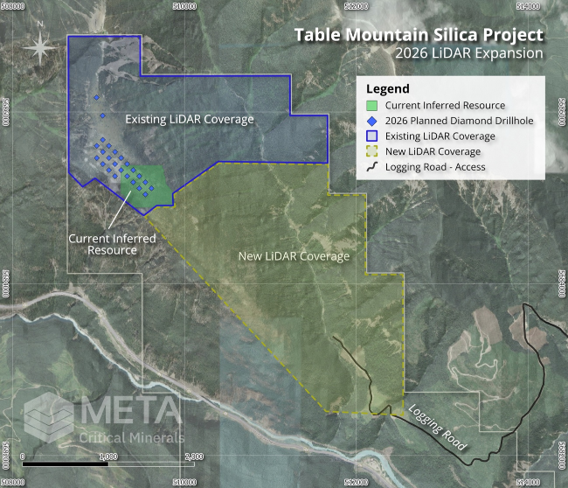
Meta Critical Minerals (MTTAF) completed an airborne LiDAR survey covering approximately 5.3 square kilometers at its wholly owned Table Mountain silica project. The September 2026 survey complements the 2025 survey, bringing combined coverage to 10.1 square kilometers near Golden, British Columbia. Processing of the laser-based terrain data and high-resolution aerial imagery is under way.
The company plans to use the data for geological mapping, an updated mineral resource estimate and a Preliminary Economic Assessment, an early-stage study of project economics. The coverage includes the main silica mineralization zone and current drilling locations. The survey complements the maiden diamond drill program, which began on October 8, 2026.
Positive
- Minor pointCompleted survey adds approximately 5.3 square kilometers to Table Mountain’s terrain coverage.
- Minor pointMaiden diamond drilling began October 8, 2026, and is under way.
- Minor point. Forward-looking: it has not happened yet and may not happen.Planned resource estimate update will use the survey’s topographic surface and surveyed drill locations.
- Minor point. Forward-looking: it has not happened yet and may not happen.Planned Preliminary Economic Assessment will be supported by the survey data.
Negative
- None.
AI-generated analysis. How Rhea-AI works. Not financial advice.


VANCOUVER, BC / ACCESS Newswire / November 12, 2026 / Meta Critical Minerals Inc. (the " Company " or " Meta ") (CSE:MTTA)(OTCQB:MTTAF)(FSE:VJ3) is pleased to announce that it has completed a high-resolution airborne LiDAR survey over its
Management Commentary
Yannis Tsitos, President of Meta, commented: "Completing the LiDAR survey gives us a detailed, three-dimensional picture of Table Mountain that we have not had before. On a forested property like this, LiDAR strips away the tree cover and shows us the shape of the quartzite ridges and the structures that control them. Together with our maiden drill program now under way, it will give us the base we need for an updated resource estimate and a Preliminary Economic Assessment. The work also fits our plan to build Table Mountain into a reliable, Canadian source of high-purity silica for the solar, semiconductor and advanced-materials supply chains. We will keep the market informed as drill results and the integrated LiDAR interpretation come in." (1)
LiDAR Survey Details & Use of LiDAR Data
The UAV-borne LiDAR survey was flown in September 2026 to complement ground towards the southeast of our 2025 LiDAR survey, which had a coverage of 4.8 Km 2 . With LiDAR data and high-resolution orthophoto processing now in progress, the combined LiDAR coverage will total 10.1 Km 2 . Therefore, there is now full coverage from the northern edge of the Property to the logging road that provides access to the southeastern base of Table Mountain from the Trans-Canada Highway, inclusive of the main zone of silica mineralization, the 2025 MRE and the current diamond drilling locations.
The survey was designed to see through the dense forest which covers parts of the Project. The LiDAR data gives the Company a modern, accurate base for all further work at Table Mountain. It will be used to:
- Geological mapping: The bare-earth model shows ridges, breaks in slope and linear features that reflect the outcrop pattern of the Mount Wilson quartzite and its contacts. Field crews can use this to refine the geological model and prioritize targets along the Project's up to 11 km of mapped strike.
- Resource estimation: An accurate topographic surface is a key input for an updated Mineral Resource Estimate. Drill collars will also be surveyed against the LiDAR surface. (1)
- Engineering and the PEA: The data will support the production of a Preliminary Economic Assessment, as well as site access and infrastructure. (1)
- Environment and access: The survey supports baseline environmental and archaeological studies, drainage mapping, and planning of further drill pads and access trails with minimal disturbance.
Finally, the survey complements the Company's maiden diamond drill program at Table Mountain, which started on October 8, 2026.
Cautionary Notes
| (1) | Mineral Resources that are not Mineral Reserves do not have demonstrated economic viability. No preliminary economic assessment, pre-feasibility study or feasibility study has been completed on Table Mountain, and no Mineral Reserves have been established. There is no certainty the Project will advance to a production decision. |
Qualified Person
Technical information in this news release has been reviewed and approved by Case Lewis, P.Geo., a "Qualified Person" as defined under NI 43-101 Standards of Disclosure for Mineral Projects and a director of the Table Mountain Project vendor.
ON BEHALF OF THE BOARD,
Rana Vig | CEO and Director
Telephone: 604-218-4766
rana@meta-cm.com
About Meta Critical Minerals Inc.
Meta Critical Minerals Inc. is a well-funded, publicly listed mining company focused on building shareholder value through the acquisition, exploration, and development of strategically located critical-mineral assets. The Company is advancing a portfolio of projects targeting silica (silicon), zircon (zirconium), titanium, scandium, vanadium, and rare earth elements, commodities that are essential to advanced manufacturing, defense systems, green power generation and electrification, and emerging technologies. Meta's assets are located in jurisdictions characterized by strong and growing demand for critical minerals, spanning Canada, U.S.A. and Central-East Asia. The Company's strategy emphasizes near-term production potential, disciplined capital allocation, and the development of assets capable of supporting a transition to cash-flow-generating operations, with the objective of delivering sustainable long-term value to shareholders, host communities, and regional stakeholders.
The Canadian Securities Exchange has not reviewed this press release and does not accept responsibility for the adequacy or accuracy of this news release.
Forward-Looking Statements
This news release contains certain forward-looking statements and forward-looking information within the meaning of applicable securities laws. Such statements include, but are not limited to, the Company's plans and expectations regarding exploration, resource definition, technical evaluation and potential development of its British Columbia critical mineral projects. Forward-looking statements are based on management's current expectations and assumptions and are subject to risks and uncertainties that could cause actual results to differ materially from those expressed or implied. These include exploration and development risks, permitting and regulatory requirements, funding availability, commodity market conditions, changes in government priorities and other risks associated with mineral exploration and development. There can be no assurance that anticipated objectives or collaborations will be achieved. Readers are cautioned not to place undue reliance on these statements. Except as required by applicable securities laws, the Company undertakes no obligation to update or revise any forward-looking statements.
SOURCE: Meta Critical Minerals Inc.
View the original press release on ACCESS Newswire
FAQ
AI-generated questions and answers. How Rhea-AI works. Not financial advice.
What did Meta Critical Minerals complete at Table Mountain?
Meta completed a high-resolution airborne LiDAR survey covering approximately 5.3 square kilometers at its wholly owned Table Mountain silica project near Golden, British Columbia. Combined with the 2025 survey, coverage totals 10.1 square kilometers.
How will Meta Critical Minerals use the Table Mountain LiDAR data for environmental and access planning?
The survey will support baseline environmental and archaeological studies, drainage mapping, and planning for further drill pads and access trails with minimal disturbance.