
Puma Exploration Completes 2,800 Line-Kilometres of Drone Magnetic Surveys
Puma Exploration (OTCQB: PUMXF, TSXV: PUMA) reported completion of six high-resolution drone magnetic survey grids totalling approximately 2,800 line‑kilometres across its McKenzie Gold, Jacquet River and Caribou East projects in northern New Brunswick.
Sentiment and the balance of points
Rhea-AI Sentiment reads the wording of the document, how positive or negative its language is on a 1 to 5 scale. The balance of points shown with the takes weighs what the document actually discloses, so the two can disagree, for example when a trial that missed its main goal is described in upbeat language.
Rhea-AI Summary
Puma Exploration (OTCQB: PUMXF, TSXV: PUMA) reported completion of six high-resolution drone magnetic survey grids totalling approximately 2,800 line‑kilometres across its McKenzie Gold, Jacquet River and Caribou East projects in northern New Brunswick. Pioneer Exploration Consultants conducted the work between June 23 and July 15, 2026, using consistent parameters for regional comparison.
The surveys cover 1,228.190 line‑kilometres at McKenzie Gold, 986.460 at Jacquet River and 585.238 at Caribou East. According to Puma Exploration, the high-quality, low-noise magnetic datasets will be integrated with mapping, geochemistry, trenching and drilling data to refine gold target generation and prioritize future exploration, including potential drilling.
Positive
- 2,799.888 line‑kilometres of new high-resolution magnetic coverage completed across three New Brunswick projects
- McKenzie Gold, Jacquet River and Caribou East grids total 3 + 1 + 2 survey blocks for regional targeting
- Pioneer reports error and noise levels below acceptance thresholds, yielding high-quality magnetic datasets for detailed interpretation
- New data will be integrated with geological and geochemical information to prioritize follow-up mapping and sampling
- Puma plans to assess structural intersections and magnetic anomaly margins as potential future drilling targets
Negative
- None.
Details
News Market Reaction – PUMXF
On Aug 25, the day this news came out, PUMXF closed 8.82% above the previous close.
Data tracked by StockTitan Argus for the Aug 25 session.
AI-generated analysis. How Rhea-AI works. Not financial advice.




Rimouski, Québec--(Newsfile Corp. - August 25, 2026) - Puma Exploration Inc. (TSXV: PUMA) (OTCQB: PUMXF) ("Puma" or the "Company") is pleased to announce the completion of six (6) high-resolution drone magnetic survey grids totalling 2,799.9 line-kilometres across its McKenzie Gold, Jacquet River and Caribou East projects in Northern New Brunswick.
The six datasets provide consistent, high-resolution data for Puma's regional geological compilation. Combined with mapping, geochemistry, historical work and known mineralized trends, the surveys will help the Company identify potential continuities and extensions of its priority gold corridors and refine targets for upcoming exploration programs.
Pioneer Exploration Consultants Ltd. ("Pioneer") completed the fieldwork from June 23 to July 15, 2026. Consistent survey parameters were used across all six grids, allowing Puma's exploration team to compare and integrate the results on a regional scale.
Survey Highlights
| Project | Survey grids | Line-kilometres |
| McKenzie Gold Project | 3 | 1,228.190 |
| Jacquet River Project | 1 | 986.460 |
| Caribou East Project | 2 | 585.238 |
| TOTAL | 6 | 2,799.888 |
Approximately 2,800 line-kilometres of new high-resolution magnetic coverage across three projects.
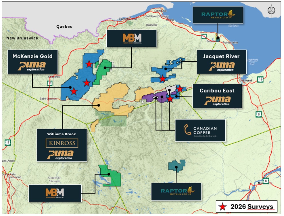
Figure 1. General Location of the surveys completed on Puma's projects in New Brunswick.
To view an enhanced version of this graphic, please visit:
https://images.newsfilecorp.com/files/3398/311194_figure1.jpg
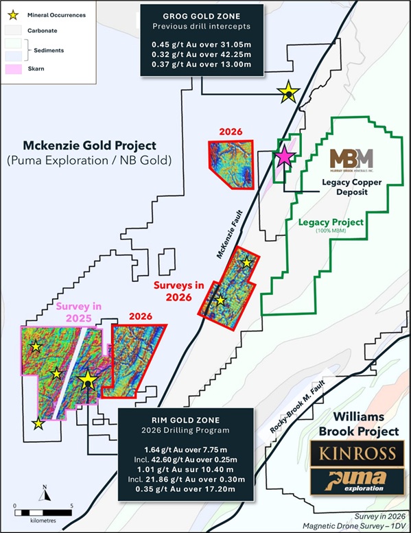
Figure 2. High-Resolution drone magnetic surveys completed at McKenzie Gold Project.
Three (3) survey grids | 1,228.190 line-kilometres.
To view an enhanced version of this graphic, please visit:
https://images.newsfilecorp.com/files/3398/311194_figure2.jpg
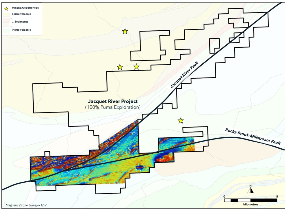
Figure 3. High-Resolution drone magnetic survey completed at Jacquet River Project. One (1) survey grid | 986.460 line-kilometres.
To view an enhanced version of this graphic, please visit:
https://images.newsfilecorp.com/files/3398/311194_figure3.jpg
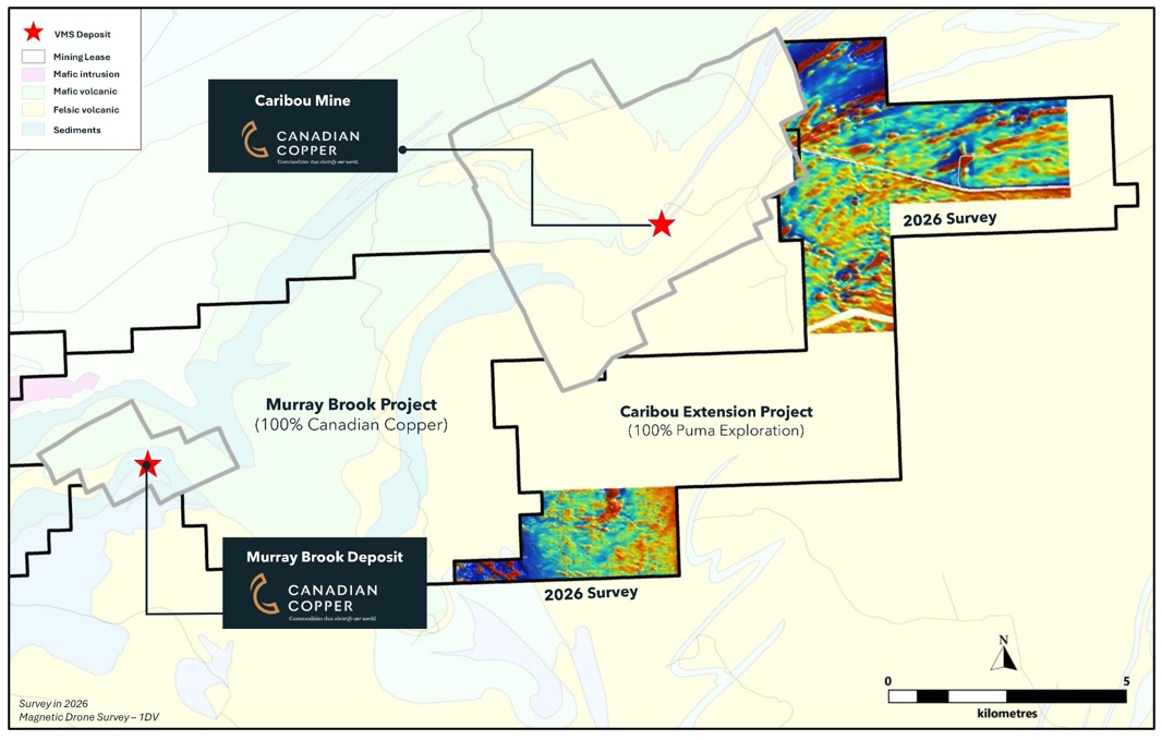
Figure 4. High-Resolution drone magnetic surveys completed at Caribou East Project. Two (2) survey grids | 585.238 line-kilometres.
To view an enhanced version of this graphic, please visit:
https://images.newsfilecorp.com/files/3398/311194_figure4.jpg
EXPLORATION TARGET GENERATION
Drone magnetic survey data is an important exploration tool for Puma, offering a high-resolution view of geological patterns and structures, even in regions where bedrock is concealed beneath overburden or glacial deposits. By analyzing these patterns alongside known gold occurrences and mineralized trends, the Company can pinpoint potential extensions of its gold corridors and focus follow-up efforts on the most promising sites, such as the Rim Gold Zone.
The new magnetic data provides an additional resource for Puma's extensive regional interpretation. When integrated with geological mapping, prospection, geochemistry, trenching, and drilling data, it helps the exploration team prioritize specific targets.
''The strength of drone magnetic surveys lies not only in their sensitivity but also in the speed and efficiency with which data can be collected across vast areas. With the advancement of drone technology, high-resolution magnetic surveys provide valuable insights into subsurface geology, allowing exploration teams to make more informed decisions before investing in costly drilling programs, making magnetic surveys indispensable from early-stage reconnaissance to eventually trenching and drilling operations,'' notes Marcel Robillard, CEO of Puma Exploration.
Pioneer reported that the final error and noise levels were below its acceptance threshold, established using Geological Survey of Canada guidelines. The survey therefore provides a high-quality, high-resolution magnetic dataset suitable for detailed geological interpretation.
NEXT STEPS
Puma is integrating the magnetic results with its geological and geochemical database to prioritize follow-up mapping and sampling. The Company will also assess prospective structural intersections, intrusive contacts and magnetic anomaly margins as potential targets for further geophysical work and future drilling.
QUALIFIED PERSON
The scientific and technical content of this press release has been prepared, reviewed, and approved by Dominique Gagné, P.Geo., who is a Qualified Person as defined by National Instrument 43-101 - Standards of Disclosure for Mineral Projects.
ABOUT PUMA EXPLORATION
Puma Exploration is a Canadian mineral exploration company focused on identifying and developing a pipeline of precious metals projects in New Brunswick, near Canada's renowned Bathurst Mining Camp. Puma has a long history in northern New Brunswick and has developed a strong understanding of the region's geology and mineralized systems through a combination of traditional prospecting, trenching, geophysics, geochemistry and advanced exploration techniques.
Connect with us on Facebook, X, or LinkedIn.
Visit www.explorationpuma.com for more information or contact:
Marcel Robillard, President and CEO.
(418) 750-8510; president@explorationpuma.com
Mia Boiridy, Head of Investor Relations and Director.
(250) 575-3305; mboiridy@explorationpuma.com
Neither the TSX Venture Exchange nor its Regulation Services Provider (as that term is defined in the policies of the TSX Venture Exchange) accepts responsibility for the adequacy or accuracy of this release.
Forward-Looking Statements: This press release may contain forward-looking statements. Such forward-looking statements involve several known and unknown risks, uncertainties, and other factors that may cause the actual results, performance, or achievements of Puma to differ materially from those expressed or implied by such forward-looking statements. Readers are cautioned not to place undue reliance on these forward-looking statements, which speak only as of the date the statements were made, except as required by law. Puma undertakes no obligation to publicly update or revise any forward-looking statements. The quarterly and annual reports, as well as the documents submitted to the securities administration, describe these risks and uncertainties.

To view the source version of this press release, please visit https://www.newsfilecorp.com/release/311194
FAQ
AI-generated questions and answers. How Rhea-AI works. Not financial advice.