Powermax Minerals Announces Commencement of Airborne Geophysical Survey at Atikokan REE Property, Northwestern Ontario
Rhea-AI Summary
Powermax Minerals (OTCQB: PWMXF) has begun a high-resolution helicopter-borne magnetic and gamma-ray spectrometric survey across its Atikokan REE Property (Blocks A, B, C) in northwestern Ontario on October 21, 2025. The program covers approximately 1,388 line-km with 100 m line spacing and will produce magnetic and radiometric products, element ratios, Geosoft-format grids, and a final technical report.
Survey data will be integrated with field mapping, geochemical sampling, and ground radiometrics as part of the Company’s 2025 Phase 1 exploration program to prioritize drill-ready REE targets for follow-up in 2026. The company also granted 200,000 stock options and 1,650,000 RSUs, both subject to shareholder approval.
Positive
- 1,388 line-km airborne survey commenced
- 9,290 hectares Atikokan property coverage
- Survey will deliver magnetic, radiometric, and Geosoft grids
- Integration planned with 2025 field mapping and geochemistry
Negative
- Granted 1,650,000 RSUs subject to shareholder approval
- Granted 200,000 options at $0.96 exercisable five years
News Market Reaction – PWMXF
In the Oct 21 session, PWMXF declined 7.35%, reflecting a notable negative market reaction.
Data tracked by StockTitan Argus on the day of publication.
AI-generated analysis. How Rhea-AI works. Not financial advice.
Vancouver, British Columbia--(Newsfile Corp. - October 21, 2025) - Powermax Minerals Inc. (CSE: PMAX) (OTCQB: PWMXF) (FSE: T23) ("Powermax" or the "Company") is pleased to announce that it has commenced a high-resolution helicopter-borne magnetic and gamma-ray spectrometric survey over the Company's Atikokan REE Properties (Blocks A, B and C) in northwestern Ontario.
Powermax has engaged Geo Data Solutions GDS Inc. ("GDS") of Laval, Québec to conduct the survey. The program will cover approximately 1,388 line-kilometres with 100-metre traverse line spacing and 500-metre tie lines, utilizing an AS350 BA+ helicopter, a Geometrics G-822A cesium magnetometer, and a Radiation Solutions RSX-5 spectrometer. Deliverables will include processed magnetic products (residual total field, first vertical derivative), radiometric products (K%, eU, eTh, dose-rate), and element ratios (U/Th, U/K, Th/K), together with a final report and Geosoft-format data and grids.
Objectives & Rationale
The airborne survey is designed to rapidly refine geological structure, map lithological variations, and highlight radiometric anomalies associated with rare earth element (REE)-bearing systems. Results will be further processed and integrated with surface mapping and geochemical data to generate and prioritize targets for subsequent fieldwork.
Technical Overview (Summary)
- Contractor: Geo Data Solutions GDS Inc. (IAGSA member)
- Platform: AS350 BA+ helicopter (or equivalent)
- Magnetics: Geometrics G-822A cesium sensor with real-time compensation
- Radiometrics: Radiation Solutions RSX-5 (4 downward + 1 upward crystals)
- Coverage: ~1,388 line-km; 100 m lines / 500 m ties; NAD83 UTM Zone 15N
- Products: Magnetic (RTP/residual, 1VD), DEM; K%, eU, eTh, dose-rate; U/Th, U/K, Th/K; PDF maps, Geosoft line database and grids; final technical report.
Planned Timeline
Subject to weather and operational conditions, GDS anticipates efficient daily production and delivery of final processed datasets and report shortly after acquisition is complete.
Integration with the 2025 Exploration Program
This airborne survey represents a key component of the Company's broader Phase 1 exploration program announced earlier this month, which includes:
- Desktop compilation and GIS modeling to integrate historical geological, geophysical, and geochemical datasets;
- Prospecting and geological mapping to identify and characterize pegmatite zones and mineralized structures;
- Geochemical sampling, including rock, soil, and stream sediment sampling; and
- Ground radiometric surveys using handheld scintillometers to support anomaly validation.
Data from the airborne program will be merged with these surface results to refine geological interpretations and prioritize high-potential REE targets for detailed follow-up exploration in 2026.
CEO Statement
"Launching this airborne program is an important step in advancing our Atikokan REE portfolio," said Paul Gorman, CEO of Powermax. "High-resolution magnetics and spectrometry are proven tools for vectoring toward REE-prospective lithologies and structures, and we look forward to translating these results into ranked drill-ready targets. By integrating airborne and ground-based datasets, Powermax aims to establish a comprehensive understanding of the property's subsurface geology and identify priority zones for rare earth element exploration."
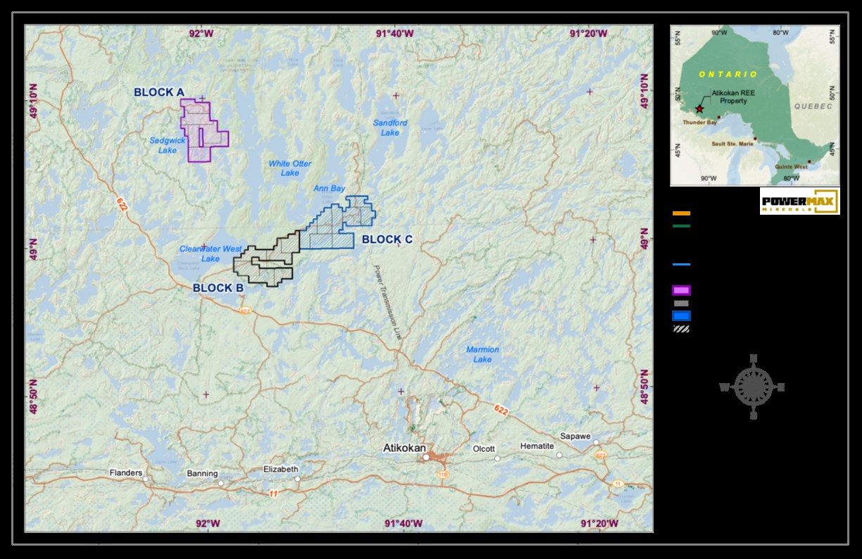
Figure 1: Atikokan Property Location Map
To view an enhanced version of this graphic, please visit:
https://images.newsfilecorp.com/files/11633/271268_d09374c4148319a5_001full.jpg
Project Significance
The Atikokan Property is strategically located within a prospective rare-metal corridor of the Superior Province, where previous surveys have documented REE-enriched granitic and pegmatitic systems. The upcoming program aims to confirm these regional geochemical trends and delineate potential mineralized zones suitable for detailed follow-up work, including trenching and diamond drilling.
Atikokan Property Overview
The Atikokan Property comprises three claim blocks (A, B, and C) covering a total of approximately 9,290 hectares. The property is underlain by Archean granodiorite-granite, tonalite, diorite-monzodiorite, and gneissic complexes that are known to host pegmatites and rare-metal mineralization, including rare earth elements (REEs), uranium, thorium, and niobium. Regional geochemical and radiometric data from the Ontario Geological Survey have outlined several lake sediment anomalies that form the focus of this phase of work.
The Company also announces that it has granted 200,000 stock options ("Options") to a consultant of the Company, pursuant to its Omnibus Plan, at an exercise price of
Qualified Person
The technical information contained in this news release has been reviewed and approved by Afzaal Pirzada, P.Geo., who is a director of the Company and a Qualified Person under National Instrument 43-101 - Standards of Disclosure for Mineral Projects.
On Behalf of the Board of Directors
Paul Gorman, CEO & Director
Email: info@powermaxminerals.com
Website: www.powermaxminerals.com
About Powermax Minerals Inc.
Powermax Minerals Inc. is a Canadian mineral exploration company focused on advancing rare earth element projects. The Company holds an option to acquire the Cameron REE Property, comprising three mineral claims totaling approximately 2,984 hectares in British Columbia. Powermax also optioned to acquire the Atikokan REE Property, consisting of 455 unpatented mining claims in NW Ontario. Powermax also owns a
Forward-Looking Statements
This news release may contain 'forward-looking statements' within the meaning of applicable Canadian securities legislation. Forward-looking statements are based on current expectations and assumptions of management and are subject to known and unknown risks, uncertainties, and other factors that may cause actual results, performance, or achievements to differ materially from those expressed or implied. Such statements include, but are not limited to, statements regarding potential mineralization, exploration plans, timing of activities, and future exploration results. Readers are cautioned not to place undue reliance on these forward-looking statements. Powermax Minerals Inc. disclaims any intention or obligation to update or revise any forward-looking statements whether as a result of new information, future events, or otherwise, except as required by applicable securities laws.
Neither the Canadian Securities Exchange nor its Market Regulator (as defined in CSE policies) accepts responsibility for the adequacy or accuracy of this news release.
![]()
To view the source version of this press release, please visit https://www.newsfilecorp.com/release/271268