
QIMC Announces Thermogenic Wet-Gas Signature in 86% of Soil-Gas Samples at New Salem-Apple River, Nova Scotia, Next to Its 30% Clean Hydrogen Discovery
Seismic acquisition is under way to test candidate structures, while the potential source rock and subsurface seal remain unconfirmed.
Sentiment and the balance of points
Rhea-AI Sentiment reads the wording of the document, how positive or negative its language is on a 1 to 5 scale. The balance of points shown with the takes weighs what the document actually discloses, so the two can disagree, for example when a trial that missed its main goal is described in upbeat language.
Rhea-AI Summary
Québec Innovative Materials (QIMCF) reported a wet-gas signature in 86% of soil-gas samples from its New Salem-Apple River exploration area in Nova Scotia. Dry gas accounted for 8.7%, while 3.4% fell in the condensate-to-oil range; biogenic and mixed signatures together represented approximately 2% of classified samples.
The company interprets the results as supporting conventional gas and helium exploration within the regional structural framework of its Bennett Hill hydrogen discovery, where holes returned up to 30% hydrogen. The gas anomalies extend about 18 km, with a core fault-controlled area of 20–30 km². A gravity low west of New Salem is interpreted as a sedimentary sub-basin that could contain organic-rich source rock. Acquisition of approximately 50 line-kilometres of 2D seismic is under way to image candidate structures. The presence of a regional evaporite seal beneath the exploration area remains to be tested by seismic and drilling.
Positive
- Minor pointWet-gas signatures in 86% of samples support QIMC's interpretation of a thermogenic hydrocarbon system.
- Minor pointGas anomalies span about 18 km, including a core fault-controlled area of 20–30 km².
- Minor point. Forward-looking: it has not happened yet and may not happen.Gravity interpretation identifies a candidate sedimentary sub-basin west of New Salem that could contain source rock.
- Minor pointAcquisition of approximately 50 line-kilometres of 2D seismic is under way to image candidate structures.
- Minor pointBennett Hill holes returned up to 30% hydrogen within the same interpreted regional structural framework.
Negative
- Minor pointPotential organic-rich source rock at depth remains a geological uncertainty for the conventional gas model.
- Minor point. Forward-looking: it has not happened yet and may not happen.The evaporite seal beneath the exploration area remains to be tested by seismic and drilling.
- Minor point. Forward-looking: it has not happened yet and may not happen.Regional salt welds and faults may act as gas leakage pathways.
AI-generated analysis. How Rhea-AI works. Not financial advice.




Results support an integrated conventional gas and helium exploration model within the same interpreted regional structural framework as QIMC's Bennett Hill hydrogen discovery. Acquisition of approximately 50 line-kilometres of 2D seismic is currently under way.
Montreal, Quebec--(Newsfile Corp. - October 6, 2026) - Québec Innovative Materials Corp. (CSE: QIMC) (OTCQB: QIMCF) (FSE: 7FJ) ("QIMC" or the "Company") today reports the C1-C4 soil-gas results from its 2026 New Salem-Apple River program in Nova Scotia and provides an integrated interpretation of the area, following the helium and geophysical results announced on September 24 and September 29, 2026. The release presents the regional gravity interpretation identifying a sedimentary sub-basin — a potential new gas kitchen — immediately west of New Salem, and sets out how the New Salem-Apple River gas corridor relates to the Company's Apple River-Bennett Hill clean natural hydrogen corridor along the North Cobequid fault zone. The interpretation and geological model were prepared by Professor Marc Richer-Laflèche, Ph.D., of the Institut national de la recherche scientifique (INRS), Québec.
The New Salem-Apple River Gas System
- Source: the organic-rich lacustrine shales of the Horton Group — the horizon the oil and gas industry has historically targeted in the Cumberland Basin — with Type II-III kerogen at thermogenic maturity (Nova Scotia government data); uranium-thorium-bearing basement, the magnetic intrusive body beneath Zones B and C and the Devono-Carboniferous granite for helium.
- Kitchen: a regional gravity low immediately west of New Salem marks a sedimentary sub-basin where the Carboniferous section thickens. C1-C4 soil-gas values rise as the gravity field falls toward the centre of this trough.
- Migration: three regional faults (F-I, F-II, F-III) rooted in Precambrian basement grain, along which gas reaches the surface today — thermogenic wet gas on F-I and F-II (Zones A and E), helium on F-III (Zones B and C) and F-II (Zone D).
- Candidate structures along faults F-I to F-III and the basin-basement ramp, to be imaged by the 2026 seismic program.
- The Windsor Group evaporites (salt and anhydrite) are the most effective regional seal; their presence beneath the fairway is to be tested by seismic and drilling.
- Footprint: a core fault-controlled fairway of 20-30 km² within an anomalous corridor extending about 18 km from West Advocate to the eastern survey lines, at the western end of the 43-kilometre Apple River-Kirkhill corridor, on which the Company's clean natural hydrogen discoveries at Bennett Hill were drilled.
Why It Matters
Twelve months ago, the south-western Cumberland Basin and its transition zone toward the Cobequid Highlands were frontier ground, with virtually no drilling and a very low density of geoscientific data; earlier industry exploration had concentrated on the central and eastern parts of the basin. It now has more than 1,000 independent soil-gas analyses for helium and C1-C4, Nova Scotia regional gravity, reprocessed provincial aeromagnetics, new QIMC high-resolution ground magnetics and a new structural interpretation — all converging on one set of structures at shallow depth, in a county with existing gas transmission infrastructure and a province that has been a net importer of natural gas.
- An active hydrocarbon charge. The dominant soil-gas signature across the survey is thermogenic, and most samples fall in the wet-gas field. This indicates that a hydrocarbon system is in the stratigraphic column beneath New Salem-Apple River — the first condition of any conventional gas play, and the reason soil-gas surveys are run ahead of seismic.
- A candidate source kitchen. The strongest ethane anomalies lie over a regional gravity low interpreted as a thickening of the sedimentary basin, which could conceal the organic-rich Horton Group lacustrine shale identified by the Nova Scotia Department of Energy as the principal geological uncertainty for the basin's conventional gas potential.
- Three gases, one structural framework. Hydrocarbons, helium and clean natural hydrogen are distinct in origin and timing but appear to share common structures: thermogenic gas associated with the basin, helium above a deep magnetic body cut by fault F-III, and hydrogen dominant toward the Cobequid Highlands, where the Company's Bennett Hill holes returned up to
30% H₂. The Nova Scotia assets no longer depend on a single commodity or a single market. - Conventional, no fracking, no reservoir stimulation. The New Salem-Apple River frontier play is a conventional gas system alongside the Company's Apple River-Bennett Hill clean natural hydrogen corridor. The Company does not use and does not intend to use hydraulic fracturing or any form of reservoir stimulation in Nova Scotia.
- Independent science. All soil-gas analyses were performed by GeoFrontiers Corporation (Wichita Falls, Texas), an independent geochemical laboratory with an analytical lineage in petroleum, natural gas and helium exploration dating to 1978. The geological and geophysical interpretation was prepared by Professor Marc Richer-Laflèche, Ph.D., INRS.
"QIMC has approached its Nova Scotia clean hydrogen discovery and now helium and wet/condensate gas systematically, with independent data, and with each stage gating the next," said John Karagiannidis, President and Chief Executive Officer. "In twelve months, we have moved from a single 28-station traverse to a frontier play with an active thermogenic charge, a candidate gas kitchen and the faults along which gas reaches the surface today — supported by more than 1 000 independent Helium and C1-C4 soil-gas analyses, regional gravity, aeromagnetics and new ground magnetics, and interpreted by one of Canada's leading academic geoscientists. The result is a conventional, shallow, multi-gas play on the same 43-kilometre basement structure as our clean natural hydrogen discoveries at Bennett Hill, in a jurisdiction with existing gas infrastructure and a structural supply deficit. We are advancing it with the discipline the asset deserves, and with 50 line-kilometres of 2D seismic designed to image the structures beneath the anomalies. Step back and look at what QIMC now holds in Nova Scotia: two districts, one basement structure, three gases. In the east, five holes across two drill centres and up to
Multi-Gas System in the New Salem-Apple River Area
Following 2025 hydrogen exploration work suggesting the possible presence of C1-C4 hydrocarbons in the terrains of the Cumberland Basin and in the transition zone toward the Cobequid Highlands, a C1-C4 soil-gas survey was carried out in the New Salem and Apple River sectors. The survey was designed to verify the likely presence of hydrocarbons in the south-western part of the basin and to assess whether an organic-rich, thermally mature source rock might be present at depth within the Carboniferous sedimentary sequence.
C1-C4 soil-gas geochemistry is widely used in the industry because it allows direct detection of hydrocarbon microseepage from the subsurface. It is typically employed during the prospect-generation stage, ahead of seismic surveys. A soil-gas anomaly indicates the presence of a hydrocarbon charge — in other words, that a petroleum system is active somewhere in the stratigraphic column.
Figure 1 compiles the soil-gas data from the 2025 and 2026 surveys, analyzed by GeoFrontiers. These data serve first to determine the type of hydrocarbons likely responsible for the C1-C4 signatures measured in the soils (C1: methane; C2: ethane; C3: propane; C4: butane). As a first approximation, a diagram adapted from Bernard et al. (1978) and Haworth et al. (1985) was used. It cross-plots two classic molecular ratios to distinguish samples with a biogenic signature from those with a thermogenic or mixed signature: the Bernard ratio, C1 / (C2 + C3), and the wetness ratio, [(C2 + C3 + C4) / (C1 + C2 + C3 + C4)] × 100.
In the present case, biogenic and mixed signatures together account for approximately
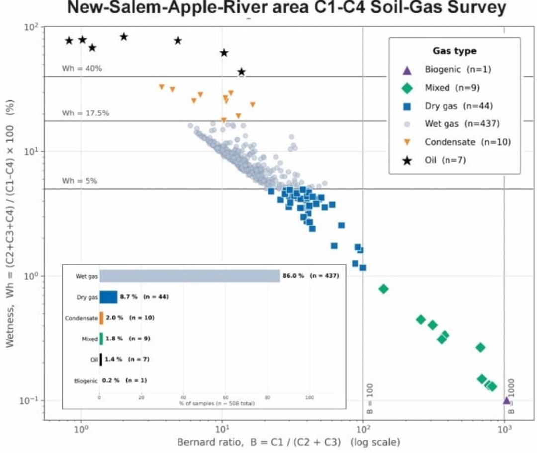
Figure 1. Subdivision diagram of the C1-C4 soil-gas analyses of the New Salem-Apple River area based on the Bernard and wetness ratios. The wetness index does not include pentane, which is not analyzed in this type of survey. Interpretation: Prof. M. Richer-Laflèche, INRS.
To view an enhanced version of this graphic, please visit:
https://images.newsfilecorp.com/files/7968/317628_68badfdee49c7a1c_001full.jpg
The diagram based on the Pixler ratios (Pixler, 1969; e.g., Rasheed et al., 2015) (Figure 2) shows a trend similar to that of Figure 1. The first- and third-quartile data for the C1/C2, C1/C3 and C1/C4 ratios fall, like the median, within the wet-gas field, with a smaller proportion in the dry-gas or oil fields. This comparison of the two methods shows consistency in the interpretation of the origin of the C1-C4 hydrocarbons detected in the soils.
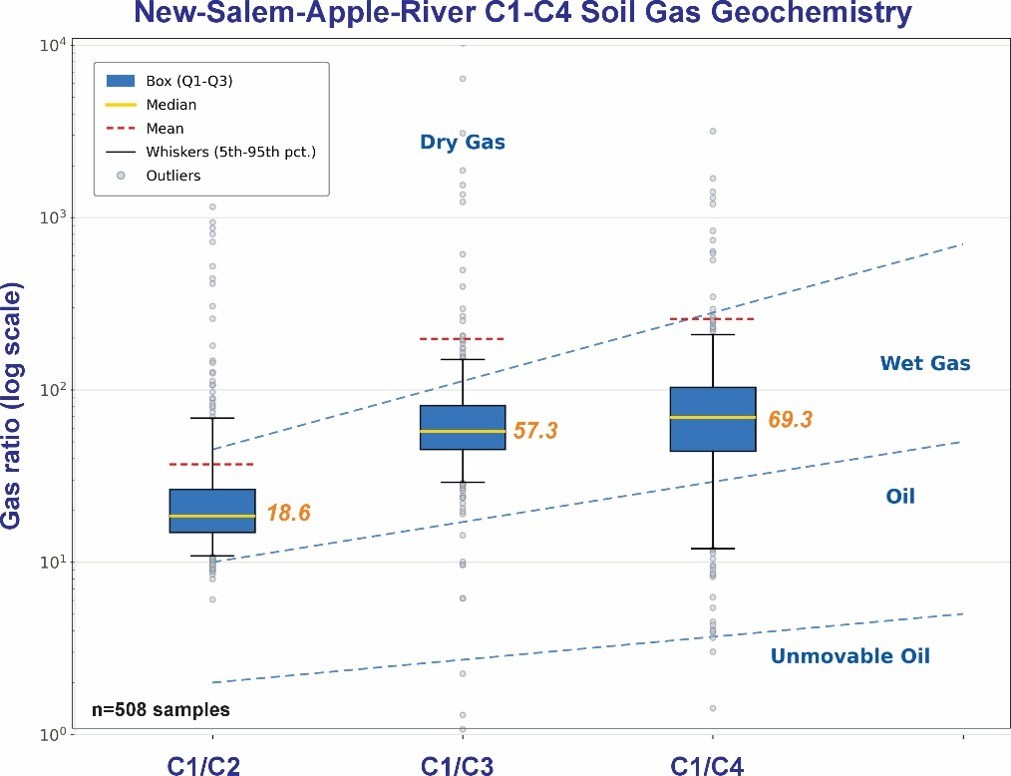
Figure 2. Subdivision diagram of the C1-C4 soil-gas analyses of the New Salem-Apple River area based on the Pixler ratios (C1/C2, C1/C3 and C1/C4).
To view an enhanced version of this graphic, please visit:
https://images.newsfilecorp.com/files/7968/317628_68badfdee49c7a1c_002full.jpg
The South-Western Sub-Basin: Gravity Locates the Kitchen
To capture the significance of the strong C1-C4 hydrocarbon concentrations found in the soils of the New Salem-Apple River area, ethane (C2) was used because, unlike methane, it is a gas essentially produced by thermogenic reactions in rock. Figure 3 shows that soils anomalous in C1-C4 hydrocarbons are not restricted to rocks of the Cumberland Group: soils overlying rocks of the Rapid Brook Formation (Horton Group) likewise show anomalous ethane and other gases.
The Bouguer anomaly map is instructive in this regard, as it reveals a spatial association between a gravity low and the strongest ethane anomalies (Figure 4). In a sedimentary basin setting, where an older, denser basement is juxtaposed against less dense sedimentary rocks, gravity lows most often reflect a thickening of the sedimentary sequence, which in turn increases, among other things, the likelihood of organic-rich source rocks being present. In the Cumberland sector, this basin thickening could conceal at depth the organic-rich lacustrine shale unit that is the missing element in current models evaluating the hydrocarbon potential of this part of the basin (e.g., Hayes et al., 2017).
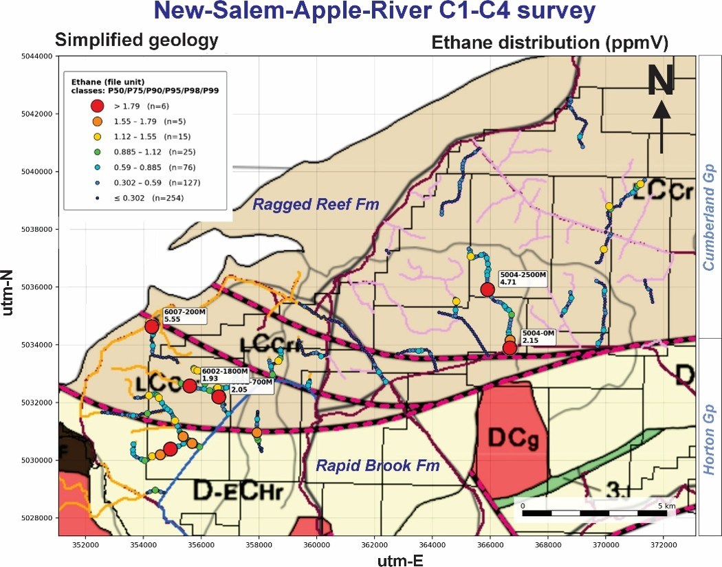
Figure 3. Ethane anomalies (ppmv) projected on the Government of Nova Scotia's simplified geological map.
To view an enhanced version of this graphic, please visit:
https://images.newsfilecorp.com/files/7968/317628_68badfdee49c7a1c_003full.jpg
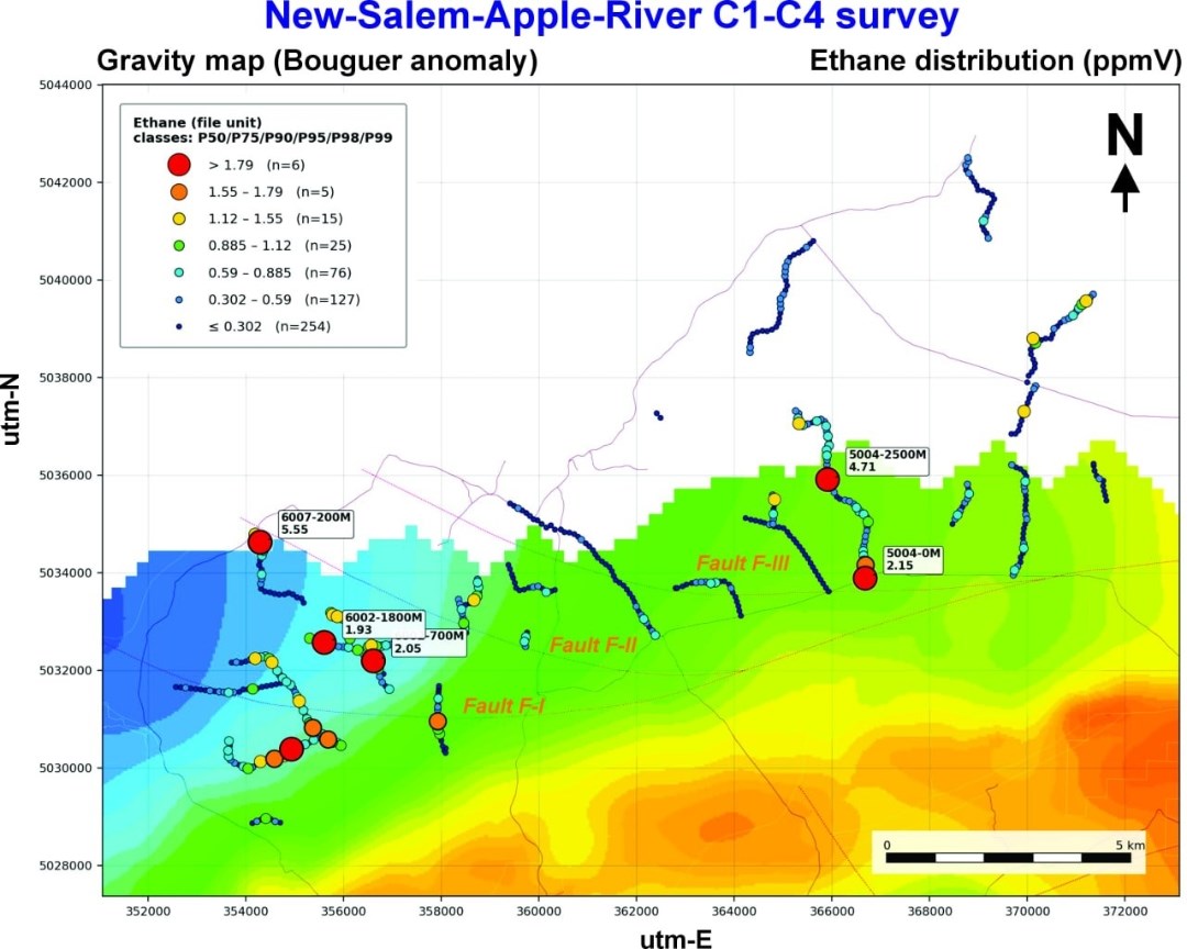
Figure 4. Ethane anomalies (ppmv) projected on the Bouguer anomaly gravity map. Interpretation: Prof. M. Richer-Laflèche, INRS.
To view an enhanced version of this graphic, please visit:
https://images.newsfilecorp.com/files/7968/317628_68badfdee49c7a1c_004full.jpg
Hydrogen, Helium and Wet/Condensate Gas in a Single Geological System
The south-western part of the Cumberland Basin and its transition zone toward the Cobequid Highlands form a complex geological and structural setting in which hydrocarbons, hydrogen and helium may coexist. They likely share common structures, but their origins differ in time and space. Understanding the geology and the formation of the gases observed in the study area therefore requires a 4D approach (3D + time).
Natural hydrogen is thought to originate mainly from the oxidation of ferrous iron (Fe²⁺) by groundwater. This reaction affects ferromagnesian minerals (olivine, pyroxenes, amphiboles, biotite) and magnetite in the mafic rocks of the Cobequid Highlands, such as the gabbros and basalts associated with the intrusions and bimodal volcanic sequences (Pe-Piper and Piper, 2002). As water oxidizes Fe²⁺ to Fe³⁺, it is reduced and releases H₂. Fluid circulation along faults and fractures promotes this reaction by continuously exposing fresh mineral surfaces. A second mechanism may also contribute: water radiolysis, the breakdown of water by radiation emitted from uranium, thorium and potassium in nearby granitoids (Sherwood Lollar et al., 2014; Klein et al., 2020). Hydrogen generation is recent on the geological time scale and, according to some hypotheses, may operate as an open system, continuously supplying gas to the subsurface over long periods (Zgonnik, 2020).
In contrast, crustal helium is almost entirely radiogenic ⁴He, produced by the decay of uranium and thorium concentrated in accessory minerals (zircon, monazite, apatite) of felsic intrusive and metamorphic rocks, particularly those of the basement (Ballentine and Burnard, 2002). A uranium- and thorium-rich source rock accumulates helium over several hundred million years; a structural, magmatic or metamorphic event can then release it, after which it migrates through the crust and may accumulate, notably in hydrocarbon reservoirs within the basin (Danabalan et al., 2022; Cheng et al., 2023).
Wet gas and condensate depend on the evolution of the sedimentary basin. The most likely source rock is the organic-rich lacustrine shale of the Horton Group (Lower Carboniferous) (Hayes et al., 2017), deposited in rift lakes and buried into the oil window, then into the wet-gas window. The Albert Formation in the Moncton Basin of New Brunswick is a recognized analogue (Mukhopadhyay, 1995; Nova Scotia Department of Energy, 2017). The system also requires reservoir rocks, structural traps and an impermeable seal. The evaporites of the Windsor Group (Viséan), composed of salt and anhydrite, form the most effective seal in the region and have low permeability to helium and hydrogen, two particularly mobile gases. In the Cumberland Basin, salt mobility has produced diapirs and minibasins (Waldron et al., 2013); these structures create traps, but also salt welds and faults that may act as leakage pathways.
In such a setting, gas mixing can be expected, along with reservoirs containing natural gas (with condensate), hydrogen and helium together. Southward, toward the Cobequid Highlands, the Carboniferous sedimentary cover thins and eventually disappears, and with it the petroleum system: source rock, reservoirs and evaporite seal. The system then becomes predominantly hydrogen-dominated. This is corroborated by thousands of soil-gas analyses and by water and mud analyses from the five QIMC boreholes drilled in 2026 in the West Advocate and Bennett Hill areas.
The System on the Seismic Map
The compilation map (Figure 5) shows the spatial relationships between the C1-C4 hydrocarbon anomalies (highlighted by ethane), helium and the main faults of the study area. This distribution reveals a decoupling between the C1-C4 hydrocarbons and helium, with the latter tending to be concentrated above a deep magnetic mass interpreted as a plutonic body underlying the basin. This mass is intersected by the F-III fault zone, which would explain the distinctive distribution of helium. By contrast, the strongest ethane anomalies occur between faults F-I and F-II, and more specifically within the zone of Bouguer anomaly attenuation corresponding to a deepening of the basin, interpreted as a ramp favouring gas migration toward the surface (Figure 4).
Figure 5 also illustrates the 2D seismic survey lines that are presently being acquired. This layout was planned based on the distribution of hydrogen, C1-C4 hydrocarbon and helium anomalies, together with the interpretation of the gravity and aeromagnetic data.
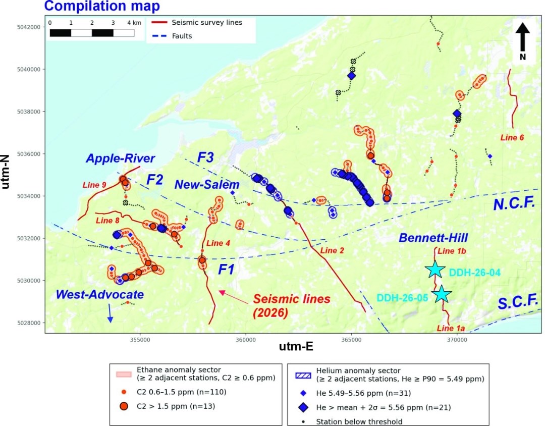
Figure 5. The New Salem-Apple River gas system on the 2D seismic program map. Diligent River Line 7 plots outside the map (east), as do the Reid Farm (West Advocate) Lines 3a and 3b (south). The map also shows the locations of boreholes DDH-26-04 and DDH-26-05, which intersected very high concentrations of hydrogen (mud and water headspace). N.C.F. and S.C.F.: North and South Cobequid faults. Compilation: Prof. M. Richer-Laflèche, INRS.
To view an enhanced version of this graphic, please visit:
https://images.newsfilecorp.com/files/7968/317628_68badfdee49c7a1c_005full.jpg
Geological and Historical Background of Hydrocarbon Exploration in the Cumberland Basin
The Cumberland Basin is a Carboniferous sub-basin of the Maritimes Basin. Since the 1970s, it has been the subject of several oil and gas exploration campaigns, none of which ever reached commercial production. An initial phase, led by Chevron in the 1970s and 1980s, assessed its conventional potential through seismic surveys and a handful of wells. In the 1990s and 2000s, attention shifted to the coalbed methane (CBM) potential of the coal-rich units of the Cumberland Group. In 2014, the adoption of a provincial moratorium on hydraulic fracturing froze all unconventional activity for more than a decade, until the legislative reopening that began in 2025.
Exploration work to date has concentrated on the central and eastern parts of the basin, particularly around the Springhill coalfield and the Amherst-Nappan-Pugwash corridor. The south-western sector, where QIMC has been active since 2025, has been largely overlooked. The earliest conventional wells (1970s-1980s) were located farther north and east, toward the Northumberland Strait coast and the Amherst area. The Springhill, River Hebert and Joggins area accounted for most of the coalbed methane exploration (Resources Enterprises in 1994, followed by Stealth Ventures and Contact Exploration from 2005 to 2009). This is also the part of the basin where coal was mined commercially, notably at Springhill and Joggins, from the 19th century through the latter half of the 20th century.
By contrast, the south-western part of the basin, in the Apple River-New Salem area, had seen virtually no drilling or detailed surveying before QIMC's arrival. This sector lies closer to the Cobequid Highlands and the Bay of Fundy. It is a frontier play area where data are extremely scarce, and the play concept therefore relies mainly on the extrapolation of regional data and models rather than on well control. In this sector, the absence of drilling explains, among other things, why the presence of organic-rich shales in the Horton Group (the source rock) cannot be confirmed. According to NSDOE Report 2017-03 (Hayes et al., 2017), this lack of exploration, combined with the absence of confirmation, constitutes the principal geological uncertainty for the Cumberland Basin's conventional natural gas potential.
No Hydraulic Fracturing, No Reservoir Stimulation
The gases identified at New Salem-Apple River — helium, thermogenic hydrocarbons and, elsewhere on the corridor, clean natural hydrogen — are migrating naturally through faults and along the basement interface to the surface today. The exploration model is therefore conventional. QIMC does not use hydraulic fracturing or any other form of reservoir stimulation and has no intention of doing so in Nova Scotia. This is a natural-flow, low-footprint exploration model, consistent with the Company's approach to clean natural hydrogen at Apple River-Bennett Hill.
References
Ballentine, C.J. and Burnard, P.G., 2002. Production, release and transport of noble gases in the continental crust. Reviews in Mineralogy and Geochemistry, 47, p. 481-538.
Bernard, B.B., Brooks, J.M. and Sackett, W.M., 1978. Light hydrocarbons in recent Texas continental shelf and slope sediments. Journal of Geophysical Research, 83(C8), p. 4053-4061.
Cheng, A., Sherwood Lollar, B., Gluyas, J.G. and Ballentine, C.J., 2023. Primary N₂-He gas field formation in intracratonic sedimentary basins. Nature, 615(7950), p. 94-99.
Danabalan, D., Gluyas, J.G., Macpherson, C.G., Abraham-James, T.H., Bluett, J.J., Barry, P.H. and Ballentine, C.J., 2022. The principles of helium exploration. Petroleum Geoscience, 28(2), petgeo2021-029.
DP ME 33, Version 2, 2006. Digital version of Nova Scotia Department of Natural Resources Map ME 1990-12, Cumberland Basin Geology Map, Amherst, Springhill and Parrsboro, Cumberland County, NTS 21H/08, 21H/09 and 21H/16, scale 1:50 000, by R.J. Ryan, R.C. Boehner, A.J. Deal and J.H. Calder, 1990.
Gibling, M.R., Culshaw, N., Rygel, M.C. and Pascucci, V., 2008. The Maritimes Basin of Atlantic Canada: basin creation and destruction in the collisional zone of Pangea. In Sedimentary Basins of the World, vol. 5, Elsevier.
Haworth, J.H., Sellens, M. and Whittaker, A., 1985. Interpretation of hydrocarbon shows using light (C1-C5) hydrocarbon gases from mud-log data. AAPG Bulletin, 69(8), p. 1305-1310.
Hayes, B.J.R., Dorey, K. and Longson, C., 2017. Assessment of Oil and Gas Potential, Windsor and Cumberland Basins, Onshore Nova Scotia. Nova Scotia Department of Energy, Open File Report 2017-03, 178 p.
Klein, F., Tarnas, J.D. and Bach, W., 2020. Abiotic sources of molecular hydrogen on Earth. Elements, 16(1), p. 19-24.
MacHattie, T.G. and White, C.E., 2013-2014. Bedrock mapping of the eastern Cobequid Highlands. Nova Scotia Department of Natural Resources, Reports of Activities.
Milkov, A.V. and Etiope, G., 2018. Revised genetic diagrams for natural gases based on a global dataset of >20,000 samples. Organic Geochemistry, 125, p. 109-120.
Pe-Piper, G. and Piper, D.J.W., 2002. A synopsis of the geology of the Cobequid Highlands, Nova Scotia. Atlantic Geology, 38, p. 145-160.
Pixler, B.O., 1969. Formation evaluation by analysis of hydrocarbon ratios. Journal of Petroleum Technology, 21(6), p. 665-670.
Prinzhofer, A., Tahara Cissé, C.S. and Diallo, A.B., 2018. Discovery of a large accumulation of natural hydrogen in Bourakebougou (Mali). International Journal of Hydrogen Energy, 43, p. 19315-19326.
Rasheed, M.A., Srinivasa Rao, P.L., Annapurna, B. and Hasan, S.Z., 2015. Implication of soil gas method for prospecting of hydrocarbon microseepage. International Journal of Petroleum and Petrochemical Engineering, 1(1), p. 31-41.
Sherwood Lollar, B., Onstott, T.C., Lacrampe-Couloume, G. and Ballentine, C.J., 2014. The contribution of the Precambrian continental lithosphere to global H₂ production. Nature, 516(7531), p. 379-382.
Waldron, J.W.F., Rygel, M.C., Gibling, M.R. and Calder, J.H., 2013. Evaporite tectonics and the late Paleozoic stratigraphic development of the Cumberland basin, Appalachians of Atlantic Canada. GSA Bulletin, 125(5-6), p. 945-960.
Zgonnik, V., 2020. The occurrence and geoscience of natural hydrogen: a comprehensive review. Earth-Science Reviews, 203, 103140.
Qualified Person
The scientific and technical information in this news release has been reviewed and approved by Professor Marc Richer-Laflèche, Ph.D., P.Geo., of the Institut national de la recherche scientifique (INRS), a Qualified Person as defined by National Instrument 43-101. Professor Richer-Laflèche led the geological and geophysical interpretation described in this release.
The geological and geophysical data underlying this release were interpreted, and the integrated New Salem-Apple River model prepared, by Professor Marc Richer-Laflèche, Ph.D., of the Institut national de la recherche scientifique (INRS), Québec, who has advised the Company on the Cumberland Basin since the inception of the program.
About Québec Innovative Materials Corp.
Québec Innovative Materials Corp. is a North American exploration and development company advancing a portfolio of natural hydrogen and critical mineral projects. The Company is advancing its district-scale hydrogen exploration model across Québec, Ontario, Nova Scotia and Minnesota, leveraging its proprietary R2G2™ framework.
QIMC is committed to responsible exploration, technical innovation and sustainable development, with the objective of supporting clean energy and decarbonization initiatives.
FOR FURTHER INFORMATION
QUÉBEC INNOVATIVE MATERIALS CORP.
John Karagiannidis
President & Chief Executive Officer
Email: info@qimaterials.com
Tel: +1 514-726-7058
Website: www.qimaterials.com
The Canadian Securities Exchange has not reviewed and does not accept responsibility for the adequacy or accuracy of the content of this news release.
Cautionary Note Regarding Forward-Looking Statements
This news release contains forward-looking statements and forward-looking information within the meaning of applicable Canadian securities laws. Such statements include, without limitation, the planned scope, timing and objectives of the Company's expanded Nova Scotia seismic program; additional soil-gas sampling and interpretation of C1-C4 hydrocarbon results; the anticipated contribution of integrated geological, geochemical and geophysical studies to exploration targeting; potential future drilling and subsurface testing; and the Company's strategy to evaluate potential conventional gas accumulations without hydraulic fracturing or reservoir stimulation. Forward-looking statements are generally identified by words such as "plans," "expects," "intends," "anticipates," "potential," "may," "will" and similar expressions, although not all forward-looking statements contain these words.
The New Salem-Apple River gas system described in this release is defined by surface geochemistry and geophysics and has not been tested by drilling. Soil-gas geochemistry indicates a hydrocarbon charge but does not locate a reservoir or trap or confirm a seal. References to a source "kitchen", to candidate structures and to a regional seal are geological interpretations of surface and regional geophysical data and do not indicate that hydrocarbons have been encountered in the subsurface or that any accumulation exists. No resource or reserve estimate has been prepared for New Salem-Apple River and none is implied. Results from the Company's drilling at Bennett Hill, 10 to 15 km east, are not necessarily indicative of conditions at New Salem-Apple River. All statements regarding future exploration, seismic and drilling activities are forward-looking.
Soil-gas composition can be altered during migration and within the soil itself. For example, oxidation of ethane to ethylene could shift the wetness and Bernard indices, and some samples could thus be displaced from the wet-gas domain toward the dry-gas domain. Isotopic analyses will help refine this classification and clarify the processes that may have altered the composition of the thermogenic gases.

To view the source version of this press release, please visit https://www.newsfilecorp.com/release/317628
FAQ
AI-generated questions and answers. How Rhea-AI works. Not financial advice.
What did QIMCF's New Salem-Apple River soil-gas survey find?
A wet-gas signature occurred in 86% of samples. Dry gas accounted for 8.7%, and 3.4% fell in the condensate-to-oil range. Biogenic and mixed signatures together accounted for approximately 2% of classified samples. QIMC interprets the dominant signature as thermogenic, meaning gas formed through heat-driven reactions in rock.
What exploration work is QIMC carrying out at New Salem-Apple River?
Acquisition of approximately 50 line-kilometres of 2D seismic is currently under way to image candidate structures. Targets include structures along faults F-I to F-III and the basin-basement ramp. The presence of the regional evaporite seal beneath the exploration area is to be tested by seismic and drilling.
Does QIMC plan to use fracking in Nova Scotia?
QIMC does not use and does not intend to use hydraulic fracturing or any form of reservoir stimulation in Nova Scotia. The company describes New Salem-Apple River as a conventional gas exploration system alongside its Apple River-Bennett Hill natural hydrogen corridor.
How were QIMC's New Salem-Apple River soil-gas results checked?
The interpretation used two molecular-ratio methods that showed consistent wet-gas classifications. The Bernard and wetness ratios were compared with Pixler ratios. GeoFrontiers performed all soil-gas analyses, and Professor Marc Richer-Laflèche of INRS prepared the geological and geophysical interpretation. The wetness index excludes pentane, which was not analyzed in this survey.