
SAGA Metals Confirms Significant Oxide Layering in the Northwest of the 100% owned Radar Titanium Project in Labrador, Canada
Rhea-AI Summary
SAGA Metals (OTCQB: SAGMF) has confirmed significant oxide mineralization in the northwest section of its 100% owned Radar Titanium Property in Labrador, Canada. Historical drill results from 1996 showed impressive grades including 40.27% Fe2O3 and 7.73% TiO2 in one sample, and 59.09% Fe2O3 and 7.32% TiO2 in another.
Recent geophysical surveys revealed magnetic highs up to 55,000 nT, indicating substantial oxide layering. The company's 2025 winter drill program yielded notable intercepts, including 20.2 meters grading 31.35% Fe, 6.32% TiO₂, and 0.435% V₂O₅. The property, spanning 24,175 hectares, benefits from excellent infrastructure including road access, deep-water port, and nearby hydroelectric power.
The company has also made progress in road maintenance and access trail development, enhancing exploration capabilities across the main oxide layering zone.Positive
- Confirmation of significant oxide mineralization with high-grade samples (up to 59.09% Fe2O3)
- Strong geophysical results showing magnetic highs up to 55,000 nT
- Excellent infrastructure including deep-water port, road access, and nearby power
- Substantial property size of 24,175 hectares with 20km strike extent
- Impressive winter drill results including 20.2m @ 31.35% Fe, 6.32% TiO₂, 0.435% V₂O₅
- Improved access through road maintenance and trail development
Negative
- Only 1/40th of the identified strike extent has been tested through drilling
- Historical drilling was limited with only 10% of drill core assayed for multi-element analysis
News Market Reaction – SAGMF
In the trading session that priced this news, SAGMF declined 8.46%, reflecting a notable negative market reaction.
Data tracked by StockTitan Argus on the day of publication.
AI-generated analysis. How Rhea-AI works. Not financial advice.




VANCOUVER, British Columbia, July 08, 2025 (GLOBE NEWSWIRE) -- SAGA Metals Corp. ("SAGA" or the "Company") (TSXV: SAGA) (OTCQB: SAGMF) (FSE: 20H), a North American exploration company focused on critical mineral discovery, is pleased to announce SAGA’s geophysics team has confirmed significant oxide mineralization in the northwest section of the
Northwest Zone, Radar Property
During the historic Voisey’s Bay nickel discovery in northern Labrador, several other companies commenced exploration initiatives across the province. One company targeted a nickel and cobalt layered mafic intrusion located in the northwestern corner of the Property (see Figure 1 below). Drilling of 350 m was completed, with approximately
Michael Garagan, CGO & Director of SAGA, comments: “Regional geophysics did not cover this section of the property, but with the one hole from the 1996 drill program data assayed for multi-element, we knew of the NW zone mineralization, we just didn’t know to what extent. While the ground crews continued to clear the old forestry road access to the Trapper zone, we commenced exploration on the NW zone. These geophysical results validate that the oxide layering zone could extend from the western part of the Trapper zone into the northwestern part. This would significantly increase our inferred oxide layering strike well beyond the current 20km.”
Radar Ti-V-Fe Project Overview:
The Company’s
The Dykes River intrusive complex is a recently recognized Mesoproterozoic layered mafic intrusion (Gower, 2017). It has gained attention due geological similarities to large AMCG-type intrusions and a very extensive titanium–vanadium–iron (Ti-V-Fe) rich layer.
Northwest Zone Geophysical Survey
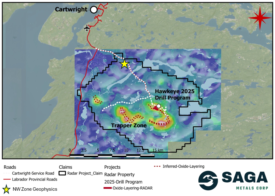
Figure 1: Map of the Radar Titanium Project showing the location of the NW Zone geophysical survey (marked with the yellow star) relative to the Hawkeye zone drill site and the Trapper Zone.
Results from a magnetic survey conducted on the NW target in June 2025 show exceptional indications of oxide layering. The data from the survey were used to produce a first vertical derivative magnetic anomaly map and a total magnetic intensity map (TMI) (see Figure 2 below). Just 9km northwest of the Hawkeye zone, the NW target contains numerous magnetic highs up to 55,000 nT (nanotesla – a unit of magnetic field strength). Outcrops of gabbronorite with
Michael Garagan, CGO & Director of SAGA, continues: “This is without a doubt another prospective target for further exploration work in the future. It also reiterates the exceptional access across the entire property and our team’s ability to traverse these important zones. Our current priority is a follow up drill campaign in the Trapper zone; however, this geophysical survey gave us our first glimpse of oxide layering towards the north and we’ll be working to confirm if this is a separate oxide zone or the continuation of the same trend highlighting the possibility that this is either a very large lopolith structure or near complete circular aerial expression.”
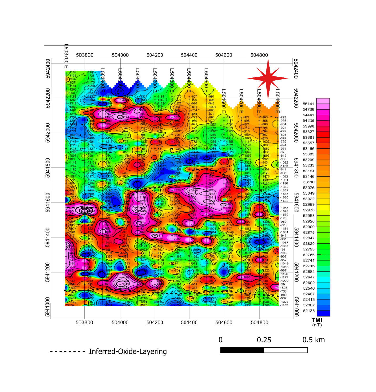
Figure 2: Total magnetic intensity (TMI) map for the NW Zone target. Major magnetic highs are in the center and southern sections of the maps. The inferred area, which includes the oxide layering, is outlined striking east-west.
Figure 2 above indicates that there are isolated to semi-continuous areas of magnetic rock. Magnetic field values in the range of 55,000 nT indicate the presence of strongly magnetic rocks. The total magnetic intensity (TMI) data which plots the change in magnetic field values in nT/m, shows high rates of change on the edges of anomalies indicated in the TMI map (Fig. 2). The high rates of change along magnetic bodies indicate sharp contacts between magnetic and nonmagnetic rocks with most of the magnetic highs located in the center of the map. These expressions of drastic high-to-low changes in magnetism are what the team identified and drilled at the Hawkeye zone. The oxide anomalies strike NE-E-W and were defined by magnetic highs, high gradients on the edges, and ground-truthed outcrops of gabbronorite, as outlined in the regional map, 1VD, and TMI (Figures 1, 2 and 3).
The survey conducted used a GEM Systems GSM-19 Magnetometer. During the survey, magnetic-field measurements and VLF-EM data were recorded. The grid used is 1 km by 1.2 km, with lines running north-south having a 100 m spacing, and stations having a 20 m spacing.
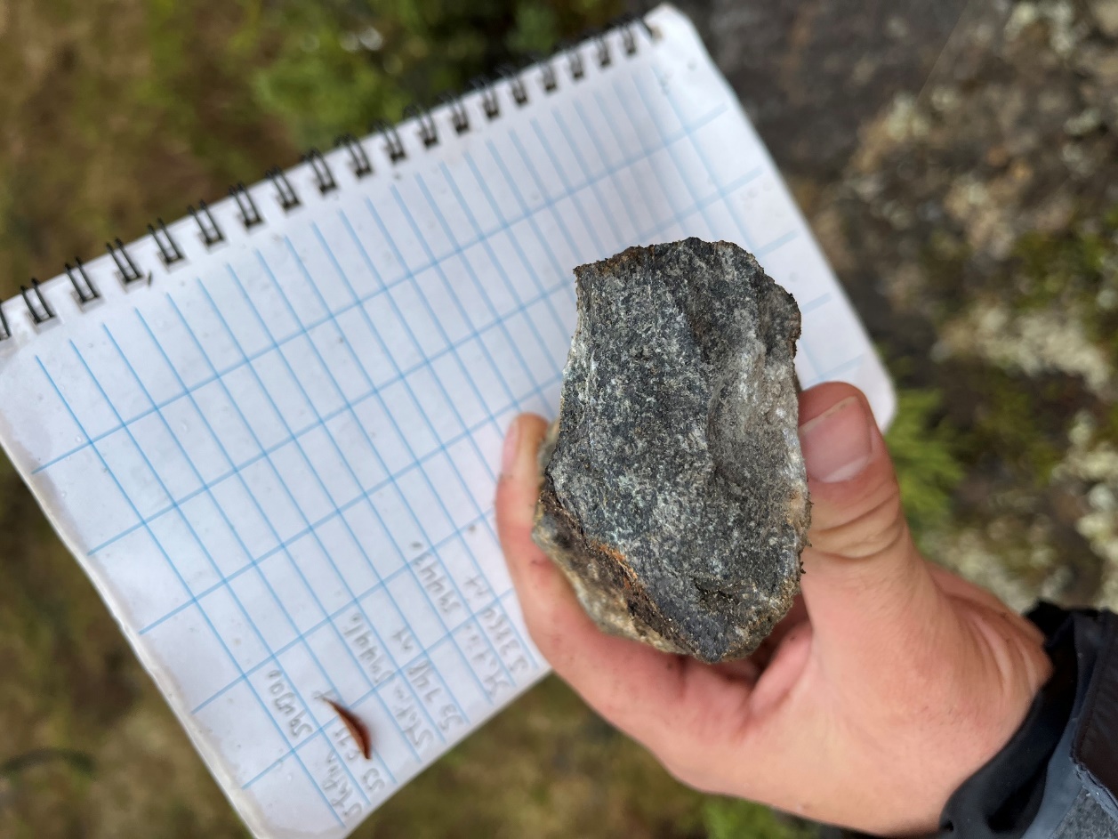
Figure 3: A piece of gabbronorite from an outcrop in the NW Zone - target. In hand sample, modal mineralogy for magnetite is
Road Maintenance and Access Trail Update
SAGA’s ground crews have successfully cleared the old forestry road of overgrowth and created the laydown at the entrance of the Tapper zone access trail. Additionally, work has commenced along the access trail with several hundred meters completed to date. It is expected that the excavator will access the center of the Tapper zone by the end of the week.
The road and trail construction aims to provide direct access to both the eastern Hawkeye Zone and the western extent of the Trapper Zone. This strategic roadwork will significantly enhance logistical and cost efficiency as well as exploration capacity across the main body of the oxide layering zone.
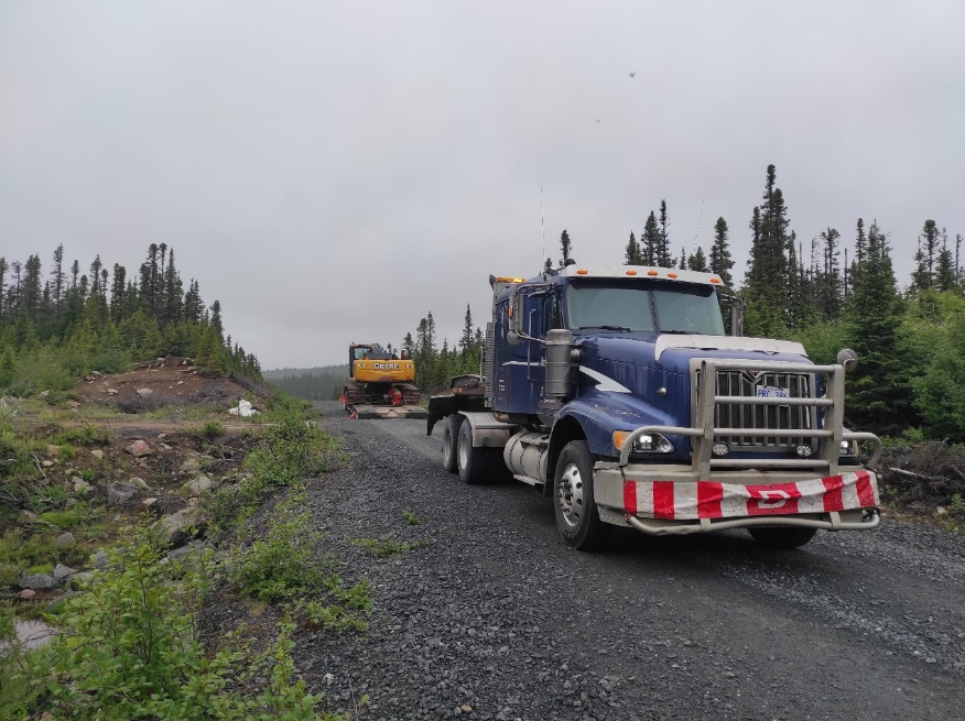
Figure 4: 25-tonne excavator arriving on site. The transport truck dropped the excavator at the junction of the main road running through the Radar Titanium Project towards the Hawkeye zone and the old forestry road.
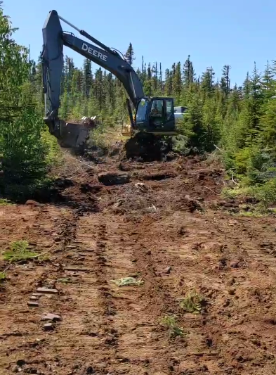
Figure 5: 25-tonne excavator creating access trail along the oxide layering strike within the Trapper Zone.
Radar Ti-V-Fe Project 2025 Winter Drill Program Highlights:
- Analytical results have been received on all seven diamond drill holes from the 2025 winter program.
- Combined with petrographic analysis, these assays confirm that the primary economic mineral is vanadiferous titanomagnetite, favourable for simplified metallurgical processing.
- Notable intercepts of vanadiferous titanomagnetite from the 2025 winter drill program include:
- 20.2 meters grading
31.35% Fe,6.32% TiO₂, and0.435% V₂O₅ in HEZ-07 - 57.7 meters grading
27.09% Fe,5.305% TiO₂, and0.365% V₂O₅ in HEZ-07 - 25.0 meters grading
19.92% Fe,4.14% TiO₂, and0.213% V₂O₅ in HEZ-05 - 31.5 meters grading
25.95% Fe,5.34% TiO2 and0.28% V2O5 in HEZ-01 - 50 meters grading
24.49% Fe,4.74% TiO2 and 0.305 % V2O5 in HEZ-04 - 28 meters grading
20.11% Fe,4.22% TiO₂, and0.214% V₂O₅ in HEZ-06 - 37 meters grading
12.4% Fe,4.17% TiO₂, and0.069% V₂O₅ in HEZ-02 - 55 meters grading
11.37% Fe,4.07% TiO₂, and0.051% V₂O₅ in HEZ-03
- 20.2 meters grading
- Titanomagnetite-rich zones average between
20% and40% titanomagnetite, with localized massive layers exceeding60% . - Drilling has confirmed the presence of oxide layering and associated magnetic anomalies to vertical depths of up to 300 meters.
- Current drilling has tested just 1/40th of the identified 20 km strike extent of the oxide layering zone within the Dykes River Intrusion (refer to Figure 1 for map view).
(Click here to see SAGA’s news release dated May 5, 2025 for full information on holes HEZ-01 & HEZ-04, here to see SAGA’s news release dated May 26, 2025 for full information on holes HEZ-05 & HEZ-07 and here to see SAGA’s news release dated May 29, 2025 for full information on holes HEZ-06, HEZ-02 & HEZ-03)
Qualified Person
Paul J. McGuigan, P. Geo., is an Independent Qualified Person as defined under National Instrument 43-101 and has reviewed and approved the technical information related to the Radar Ti-V-Fe Project disclosed in this news release.
About SAGA Metals Corp.
SAGA Metals Corp. is a North American mining company focused on the exploration and discovery of a diversified suite of critical minerals that support the global transition to green energy. The Radar Titanium Project comprises 24,175 hectares and entirely encloses the Dykes River intrusive complex, mapped at 160 km² on the surface near Cartwright, Labrador. Exploration to date, including a 2,200m drill program, has confirmed a large and mineralized layered mafic intrusion hosting vanadiferous titanomagnetite (VTM) with strong grades of titanium and vanadium.
The Double Mer Uranium Project, also in Labrador, covers 25,600 hectares featuring uranium radiometrics that highlight an 18km east-west trend, with a confirmed 14km section producing samples as high as
Additionally, SAGA owns the Legacy Lithium Property in Quebec's Eeyou Istchee James Bay region. This project, developed in partnership with Rio Tinto, has been expanded through the acquisition of the Amirault Lithium Project. Together, these properties cover 65,849 hectares and share significant geological continuity with other major players in the area, including Rio Tinto, Winsome Resources, Azimut Exploration, and Loyal Metals.
With a portfolio that spans key minerals crucial to the green energy transition, SAGA is strategically positioned to play an essential role in the clean energy future.
On Behalf of the Board of Directors
Mike Stier, Chief Executive Officer
For more information, contact:
Rob Guzman, Investor Relations
SAGA Metals Corp.
Tel: +1 (844) 724-2638
Email: rob@sagametals.com
www.sagametals.com
Neither the TSX Venture Exchange nor its Regulation Service Provider (as that term is defined in the policies of the TSX Venture Exchange) accepts responsibility for the adequacy or accuracy of this release.
Cautionary Disclaimer
This news release contains forward-looking statements within the meaning of applicable securities laws that are not historical facts. Forward-looking statements are often identified by terms such as “will”, “may”, “should”, “anticipates”, “expects”, “believes”, and similar expressions or the negative of these words or other comparable terminology. All statements other than statements of historical fact, included in this release are forward-looking statements that involve risks and uncertainties. In particular, this news release contains forward-looking information pertaining to the exploration of the Company’s Radar Project. There can be no assurance that such statements will prove to be accurate and actual results and future events could differ materially from those anticipated in such statements. Important factors that could cause actual results to differ materially from the Company’s expectations include, but are not limited to, changes in the state of equity and debt markets, fluctuations in commodity prices, delays in obtaining required regulatory or governmental approvals, environmental risks, limitations on insurance coverage, risks and uncertainties involved in the mineral exploration and development industry, and the risks detailed in the Company’s continuous disclosure filings with securities regulations from time to time, available under its SEDAR+ profile at www.sedarplus.ca. The reader is cautioned that assumptions used in the preparation of any forward-looking information may prove to be incorrect. Events or circumstances may cause actual results to differ materially from those predicted, as a result of numerous known and unknown risks, uncertainties, and other factors, many of which are beyond the control of the Company. The reader is cautioned not to place undue reliance on any forward-looking information. Such information, although considered reasonable by management at the time of preparation, may prove to be incorrect and actual results may differ materially from those anticipated. Forward-looking statements contained in this news release are expressly qualified by this cautionary statement. The forward-looking statements contained in this news release are made as of the date of this news release and the Company will update or revise publicly any of the included forward-looking statements only as expressly required by applicable law.
Photos accompanying this announcement are available at
https://www.globenewswire.com/NewsRoom/AttachmentNg/558d6c96-3e2e-48a1-be1f-f16e87b0f645
https://www.globenewswire.com/NewsRoom/AttachmentNg/22ff0c4b-c587-4d11-8e07-78ce744dd0ce
https://www.globenewswire.com/NewsRoom/AttachmentNg/9f98105f-fa33-4ebb-9032-2cd1590a8f56
https://www.globenewswire.com/NewsRoom/AttachmentNg/d93a1bd6-222f-4b3a-9432-75b68161e778
https://www.globenewswire.com/NewsRoom/AttachmentNg/e28c955a-7967-4fa7-af3c-553a9d427460
