
Spark Returns 2.00% TREO in a Grab Sample at the Cruzeta Road Cut; Drilling Planned Below
Metallurgical recovery has not been demonstrated, and the interpreted ionic adsorption clay mineralization remains unconfirmed.
Sentiment and the balance of points
Rhea-AI Sentiment reads the wording of the document, how positive or negative its language is on a 1 to 5 scale. The balance of points shown with the takes weighs what the document actually discloses, so the two can disagree, for example when a trial that missed its main goal is described in upbeat language.
Rhea-AI Summary
Spark Energy Minerals (SPARF) reported a Cruzeta granite grab sample containing 2.00% total rare earth oxides, identifying a second exploration target style. The hand-collected sample is not representative of the target or comparable with channel or drill results. Magnet rare earth oxides accounted for at least 36.0% of its total. Praseodymium exceeded the laboratory method’s limit; Spark expects a higher final value after additional analysis.
A 22 m horizontal channel averaged 2,392 ppm total rare earth oxides, with a 28.6% magnet rare earth share; a 4 m vertical channel averaged 1,725 ppm, with a 21.2% share. Surface sampling does not establish thickness or continuity. Spark plans drilling below the road cut and infill drilling, subject to financing. Nine completed holes await reporting after quality-control review. Separately, 750,000 immediately vested director stock options were granted at $0.05, exercisable for three years.
How this balance works
Rhea-AI gives every point it takes from this document a weight. Minor counts 1, Moderate 3 and Major 9, so one Major point outweighs several Minor ones. The bar adds up the weights on each side, and when neither side holds more than 65% of the total the balance reads Mixed.
It reads the document as published, with the same rules for every company, and it does not look at what the market expected or at how the stock traded, so a point can be objectively good on a day the stock falls.
Rhea-AI Sentiment measures something else, the tone of the wording.
Hollow bars mark forward-looking points. How the balance works
Positive
- Moderate pointAll 33 disclosed drill holes across Cruzeta and Boa Vista contained gallium and rare earth mineralization.
- Minor pointGranite grab sample returned 19,991 ppm (2.00%) total rare earth oxides, Spark’s highest reported single-sample Arapaima assay.
- Minor pointMagnet rare earth oxides represented at least 36.0% of total rare earth oxides in the grab sample.
- Minor point22 m horizontal channel averaged 2,392 ppm total rare earth oxides; all 22 one-metre samples exceeded 1,600 ppm.
- Minor pointHorizontal channel peak reached 4,765 ppm total rare earth oxides.
6 minor points
- Minor pointHorizontal channel magnet rare earth share averaged 28.6%, with an individual-sample maximum of 34.0%.
- Minor point4 m vertical channel averaged 1,725 ppm total rare earth oxides, rising from 1,358 to 2,051 ppm downward.
- Minor pointVertical channel magnet rare earth share averaged 21.2%, rising from 11.0% at the top to 28.6% at the base.
- Minor pointFive nearby previously reported holes ended above 500 ppm total rare earth oxides without reaching the zone’s base.
- Minor point. Forward-looking: it has not happened yet and may not happen.Road-cut drill hole is planned to test mineralization at depth, including the granite target.
- Minor point. Forward-looking: it has not happened yet and may not happen.Cruzeta infill drilling remains in planning to support a potential future mineral resource estimate.
Negative
- Moderate pointFuture fieldwork remains subject to financing; infill drilling has not started and is required before a resource estimate.
- Moderate point. Forward-looking: it has not happened yet and may not happen.750,000 immediately vested stock options granted September 18, 2026, permit new shares at $0.05 for three years, potentially diluting holders.
- Minor pointGrab sample is not representative of the granite or target and is not comparable with channel or drill results.
- Minor pointSurface results do not establish mineralization thickness, continuity or depth extent; continuity between drill holes remains undemonstrated.
- Minor pointIonic adsorption clay interpretation remains unconfirmed; total-digestion assays do not establish the proportion of ionically adsorbed rare earths.
- Minor pointMetallurgical recovery has not been demonstrated, and the granite sample’s rare earth host minerals remain unidentified.
AI-generated analysis. How Rhea-AI works. Not financial advice.




Magnet rare earths account for at least
Vancouver, British Columbia--(Newsfile Corp. - October 8, 2026) - Spark Energy Minerals Inc. (CSE: SPRK) (OTC Pink: SPARF) (FSE: 8PC) ("Spark" or the "Company") reports channel and grab sampling results that point to a second rare earth target style at Cruzeta, within its approximately 91,900-hectare Arapaima Project in Minas Gerais, Brazil.
A grab sample of lightly weathered granite at the base of the road-cut face returned 19,991 ppm (
In that sample praseodymium exceeded the upper limit of the laboratory method, so the
Granite-Hosted Rare Earths Point to a Second Target Style at Cruzeta
"Here, the channels expose the rare earth zone right at surface, while our nearest drill holes encounter it 22 to 42 metres down, consistent with our model of a vertically zoned weathering profile. The grab sample is granite, not clay, which opens a second target style at Cruzeta beyond our ionic clay model. One sample does not make a deposit, so our first follow-up is a drill hole at the top of the road cut.
"Strategically, Cruzeta is where we are building the technical foundation for everything that follows at Arapaima. The sequence is clear: drill beneath the road cut, report the remaining drill holes, and plan the infill drilling that any future mineral resource estimate would require, all subject to financing. A rigorous, verifiable technical record is what allows a company at our stage to engage strategic partners, institutional investors and public agencies with credibility. With approximately 91,900 hectares,
A road cut is the exposed face created where ground is excavated to build a road. At Cruzeta, it gives geologists direct access to the weathered profile and underlying granite. The section below shows how this exposure relates to nearby drilling and the proposed drill test.
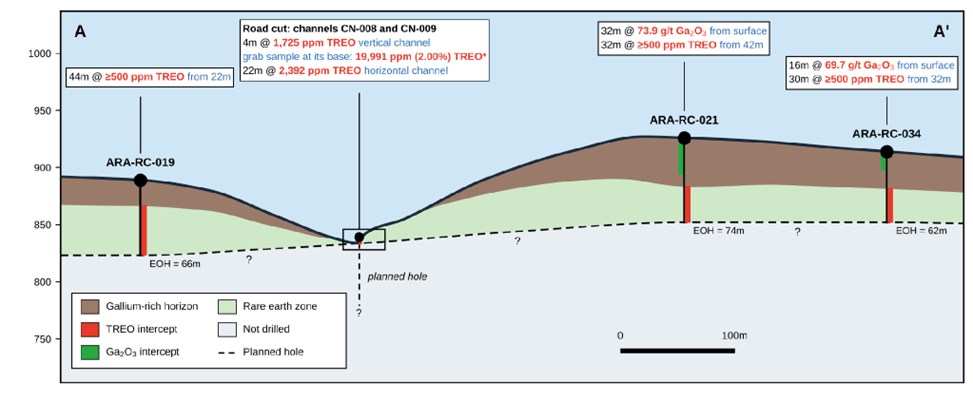
Figure 1. Section A-A′ through the Cruzeta road cut and nearby drill holes, looking north-northeast, with no vertical exaggeration. Ground between surveyed points is schematic; interpreted contacts place the base of the gallium-rich horizon at the top of each hole's rare earth interval. The dashed boundary marks the limit of drilling and sampling; the vertical dashed line is the planned hole. Continuity between holes has not been demonstrated. * Final value expected to be higher; see Technical Notes and Reporting Basis.
To view an enhanced version of this graphic, please visit:
https://images.newsfilecorp.com/files/10093/318021_f0c45c58041b6bdf_001full.jpg
High Grades and Magnet Rare Earth Shares Strengthen the Surface Target
Grab sample ARA-CN-008-05: 19,991 ppm (
2.00% ) TREO. Lightly weathered granite at the base of the road-cut face, with magnet rare earth oxides (MREO) accounting for at least36.0% of TREO. The final TREO, MREO and NdPr values are expected to be higher: see "Technical Notes and Reporting Basis".Horizontal channel CN-009: 22 m averaging 2,392 ppm TREO, peak 4,765 ppm. Every one of the 22 one-metre samples exceeds 1,600 ppm TREO.
Vertical channel CN-008: 4 m averaging 1,725 ppm TREO. TREO rises down the channel, from 1,358 ppm in soil at the top to 2,051 ppm in saprolite at the base.
Peak magnet rare earth shares:
34.0% of TREO in CN-009 and28.6% in CN-008. These are individual channel-sample ratios, distinct from the grab sample's minimum36.0% .Average magnet rare earth shares:
28.6% of TREO across CN-009 and21.2% across CN-008. Channel ratios are total MREO divided by total TREO.
22 m Channel Averages 2,392 ppm TREO Across the Sampled Face
The program comprised 26 one-metre channel samples and one grab sample (Figures 2 and 3). CN-008 is a 4 m vertical channel cut down the road-cut face, from soil at the top to saprolite at the base. CN-009 is a 22 m horizontal channel that starts about 6 m from CN-008 and follows the face southward. ARA-CN-008-05 is a grab sample of the lightly weathered granite exposed at the base of the face, directly below CN-008. Results for every sample, with coordinates, are in the Appendix.
No new drill holes are reported. Surface samples do not establish the thickness, continuity or depth extent of mineralization.
| Channel or sample | Type | Length (m) | TREO average (ppm) | TREO maximum (ppm) | MREO/TREO average (%) | MREO/TREO maximum (%) |
| CN-008 | Vertical channel | 4 | 1,725 | 2,051 | 21.2 | 28.6 |
| CN-009 | Horizontal channel | 22 | 2,392 | 4,765 | 28.6 | 34.0 |
| ARA-CN-008-05 | Grab sample | - | - | 19,991* | - | 36.0* |
Table 1. Channel and grab sampling results at Cruzeta
Averages are of consecutive one-metre channel samples; MREO/TREO averages are total MREO divided by total TREO. ARA-CN-008-05 is a single grab sample: its values are individual results, and it is not part of channel CN-008. * Final value expected to be higher: see "Technical Notes and Reporting Basis".
Every CN-009 sample exceeds 1,600 ppm TREO (Photo 1). The highest, ARA-CN-009-19, returned 4,765 ppm TREO with
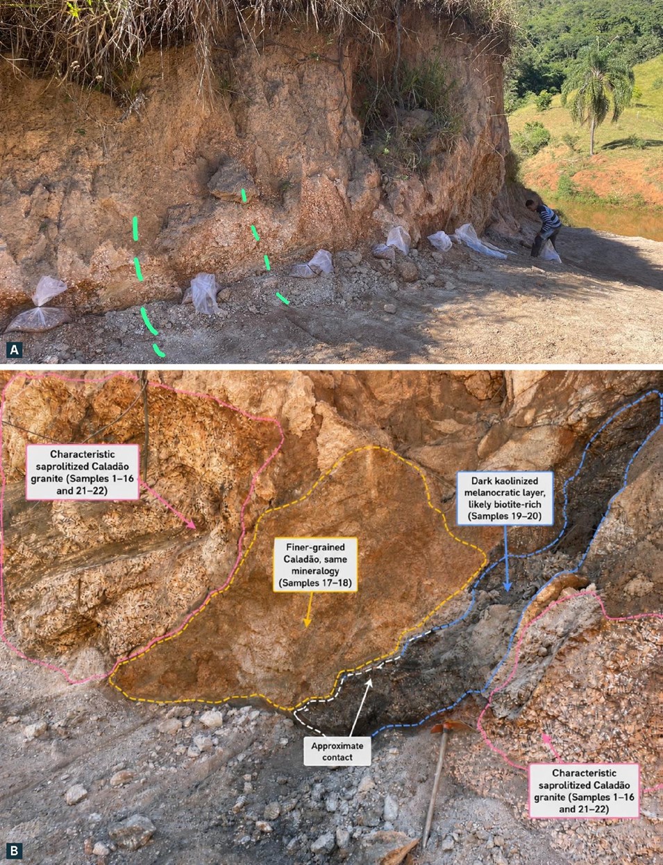
Photo 1. Horizontal channel CN-009 at the Cruzeta road cut. (A) Bagged one-metre samples below strongly weathered Caladão Granite with preserved rock texture beneath soil; green dashes mark a one-metre interval. (B) Approximate field outlines near the channel's southern end: coarse saprolite (pink; samples 01-16, 21 and 22), a finer-grained variety with the same minerals (yellow; 17 and 18), and a strongly kaolinized layer rich in dark minerals, likely biotite (blue; 19 and 20). The channel's highest TREO sample, 19, is from the dark layer.
To view an enhanced version of this graphic, please visit:
https://images.newsfilecorp.com/files/10093/318021_f0c45c58041b6bdf_002full.jpg
CN-008 averages 1,725 ppm TREO over its 4 m (Photo 2). TREO rises down the channel from 1,358 ppm in the soil at the top to 2,051 ppm in the saprolite at the base, and the magnet rare earth share rises with it, from
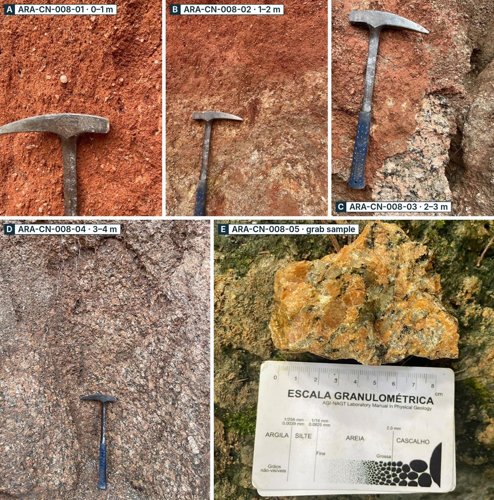
Photo 2. From soil to granite at the Cruzeta road cut. Panels A-D show successive one-metre sampling intervals in vertical channel CN-008, progressing from red soil through a transition zone into saprolite. Panel E shows the lightly weathered granite fragment collected with smaller chips as grab sample ARA-CN-008-05, directly below the channel.
To view an enhanced version of this graphic, please visit:
https://images.newsfilecorp.com/files/10093/318021_f0c45c58041b6bdf_003full.jpg
All Five Nearby Drill Holes Ended in Rare Earth Mineralization. Five previously reported holes lie within 500 m of the channels, 197 to 465 m away (Figure 2; Appendix, Tables A3 and A4). In each of them, grades above 500 ppm TREO start 22 to 42 m below surface, beneath an upper zone in which four of the five holes carry a gallium interval from surface. All five holes ended in grades above 500 ppm TREO, so none reached the base of the rare earth zone.
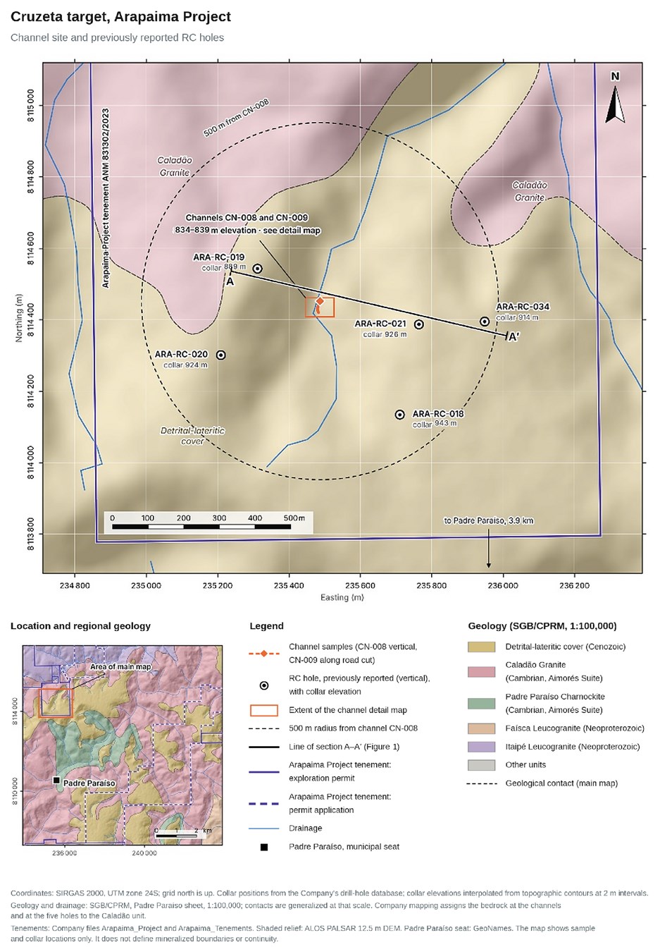
Figure 2. Cruzeta channel site, the five previously reported RC collars within 500 m of CN-008, and section A-A′ (Figure 1). Locations do not establish mineralization boundaries or continuity.
To view an enhanced version of this graphic, please visit:
https://images.newsfilecorp.com/files/10093/318021_f0c45c58041b6bdf_004full.jpg
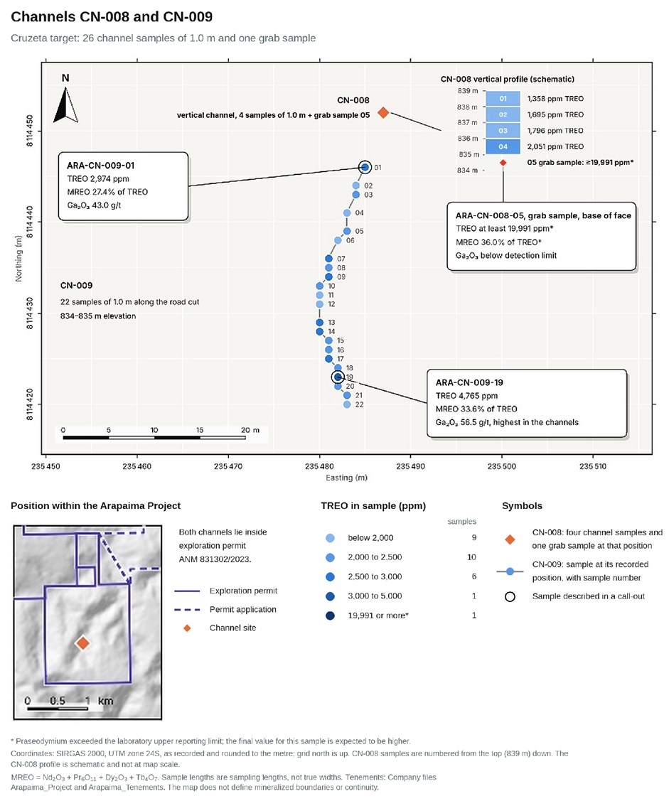
Figure 3. Sample locations and TREO classes for CN-008 and CN-009, with a schematic CN-008 profile and the grab sample below it.
To view an enhanced version of this graphic, please visit:
https://images.newsfilecorp.com/files/10093/318021_f0c45c58041b6bdf_005full.jpg
Surface Results Support the Model of a Vertically Zoned Profile
Both channels were cut in the weathering profile of the Caladão Granite. Horizontal channel CN-009 is in saprolite: clay-rich material formed by the in-situ weathering of the granite, in which the texture of the parent rock is preserved (Photo 1). Vertical channel CN-008 passes from red soil in its top metre through a transition zone into saprolite, above lightly weathered granite at the base of the face, where the grab sample was taken (Photo 2). Field descriptions record quartz fragments in the soil, weathered granite fragments in the transition zone, coarse saprolite with feldspar and dark minerals becoming slightly denser at the channel base, and coarse-grained granite with feldspar, quartz and dark minerals in the grab sample. In the Company's exploration model, developed from RC drilling at Cruzeta, the weathering profile is vertically zoned, with gallium enriched in its upper part and rare earths enriched in the saprolite below. The Company has reported results for 28 RC holes at Cruzeta (news releases of February 10 and 13, 2026, as clarified on March 12, 2026, and of July 22 and August 13, 2026).
The road cut. The channels are at about 834 to 839 m elevation, about 50 to 110 m below the five nearest collars (Figure 1), and grades above 500 ppm TREO start at surface there. Channel gallium values of 28 to 56 g/t Ga₂O₃ are mostly lower than the gallium intervals from surface in the drill holes, which average 58 to 74 g/t Ga₂O₃. The Company interprets the gallium-rich upper part of the profile as having been removed at this position, by erosion in the valley or by the cut itself, so that the channels sample the rare earth zone directly. This interpretation is consistent with the Company's model of a vertically zoned weathering profile and has not been tested by drilling.
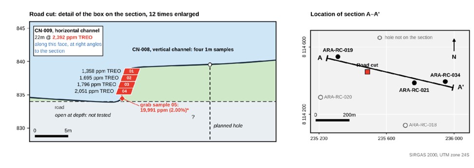
Figure 4. Cruzeta road-cut detail, enlarged 12 times relative to Figure 1 (left), and section A-A′ location (right). Ground between surveyed points is schematic, contacts are interpreted, and continuity between holes has not been demonstrated. The dashed boundary marks the limit of drilling and sampling; the vertical dashed line is the planned hole. * Final value expected to be higher; see Technical Notes and Reporting Basis.
To view an enhanced version of this graphic, please visit:
https://images.newsfilecorp.com/files/10093/318021_f0c45c58041b6bdf_006full.jpg
Magnet rare earths. In CN-008 the magnet rare earth share rises down the channel, from
The Company interprets the rare earth mineralization at Cruzeta as ionic adsorption clay (IAC)-style, in which a portion of the rare earths released by weathering of the granite is adsorbed onto clay minerals. That interpretation has not been confirmed, and it does not extend to the grab sample. The assays in this news release were obtained by sodium peroxide fusion, a total-digestion method that measures the full rare earth content of each sample, including rare earths held within minerals. They do not indicate what proportion, if any, is ionically adsorbed. No mineralogical or leach test work is reported in this news release, and no metallurgical recovery has been demonstrated.
A second target style. The grab sample is lightly weathered granite, not clay, and its grade is more than ten times the average of the channel above it. It points to rare earth mineralization hosted in rock, a different target from the IAC model. It may reflect primary mineralization in the granite or enrichment at the base of the weathering profile; which of the two has not been determined, and the minerals that host the rare earths have not been identified. The planned drill hole at the road cut is intended to test it.
Building on Exploration Success at Cruzeta and Boa Vista
Spark has reported gallium and rare earth mineralization in all 33 RC holes disclosed across Cruzeta and Boa Vista, two mineralized centres within its approximately 91,900-hectare Arapaima Project in Brazil's Lithium Valley. The new Cruzeta surface results build on that drilling record and identify a granite-hosted rare earth target alongside the Company's interpreted clay-hosted mineralization. Results from nine additional completed holes remain to be reported following quality-control review. (see September 24, 2026 news release)
Nine Completed Holes Await Reporting as Spark Plans the Next Drill Test
The next phase is intended to test below the road-cut exposure and support continued exploration planning at Cruzeta. Future fieldwork remains subject to financing, and there is no assurance that the planned work will be completed as described.
A drill hole at the road cut. Nothing has been sampled below the base of the road-cut face. The Company plans to collar a drill hole at the top of the road cut, where access allows, to test the mineralization at depth, including the granite from which the grab sample was taken.
The over-limit rare earth analysis. The Company has requested from SGS Geosol an over-limit analysis of ARA-CN-008-05 for the rare earth elements, by a method that reports praseodymium above the 1,000 ppm limit; the final TREO value for the sample will be reported when it is received.
Reporting of assay results for the nine completed RC holes at Arapaima that have not yet been reported, after quality-control review.
Continued planning of an infill drilling program at Cruzeta. Infill drilling has not started. It would be required before any mineral resource estimate could be prepared, and there is no certainty that it will result in the delineation of a mineral resource.
Complete Results for All 27 Samples
Results for all 26 channel samples and for the grab sample, with their coordinates, are tabulated in the Appendix (Tables A1 and A2). The 15 individual rare earth oxide values from which TREO, MREO and NdPr are calculated are tabulated for every sample in Table A5 of the Appendix.
Stock Option Grant
The Company also announces that on September 18, 2026, it granted 750,000 stock options to a member of its Board of Directors. Each option is exercisable to purchase one common share at
Technical Notes and Reporting Basis
"TREO" means total rare earth oxides and is calculated as the sum of CeO₂, La₂O₃, Pr₆O₁₁, Nd₂O₃, Sm₂O₃, Eu₂O₃, Gd₂O₃, Tb₄O₇, Dy₂O₃, Ho₂O₃, Er₂O₃, Tm₂O₃, Yb₂O₃, Lu₂O₃ and Y₂O₃. "MREO" means magnet rare earth oxides and is calculated as Nd₂O₃ + Pr₆O₁₁ + Dy₂O₃ + Tb₄O₇; samarium is not included. "NdPr" means Nd₂O₃ + Pr₆O₁₁. MREO and NdPr are components of TREO and must not be added to it. The four magnet rare earths are those used in permanent magnets, which is why the Company reports the MREO/TREO ratio alongside the TREO grade. TREO is reported in parts per million (ppm); 10,000 ppm equals
Gallium, scandium and lithium are reported in the Appendix for completeness, as gallium oxide (Ga₂O₃) and scandium oxide (Sc₂O₃) in grams per tonne and lithium oxide (Li₂O) in parts per million, calculated from elemental assays using factors of 1.3442, 1.5338 and 2.1525 respectively. In the 27 samples (26 channel samples and the grab sample) gallium ranges from below detection, in the grab sample, to 56.5 g/t Ga₂O₃; scandium is below detection in 20 of the 27 samples; and lithium does not exceed 398 ppm Li₂O, which the Company does not regard as lithium mineralization.
TREO, MREO and NdPr are sums of individual oxide values calculated from elemental assays. They are not measured directly, and they do not reflect differences in the value, distribution or metallurgical behaviour of the individual elements. All oxide values in this news release are in-situ analytical results only. They should not be interpreted as recoverable oxides, metal-equivalent grades, mineral-equivalent grades or implied metallurgical recoveries.
All channel values are assays of individual one-metre samples. The averages quoted for channels CN-008 and CN-009 are arithmetic means of their consecutive, equal-length samples, and no result below detection enters any reported average. Sample lengths are sampling lengths, vertical in CN-008 and horizontal, along the road-cut face, in CN-009. They are not true widths or thicknesses of mineralization, which are not known. ARA-CN-008-05 is a grab sample of the coherent, lightly weathered granite exposed at the base of the road-cut face: a hand-sized fragment with a few smaller chips, about 700 g in total, collected by hand, without a measured length. Its result is reported as an individual sample, is not included in any average, and is not representative of the channel, of the granite or of the target; grab samples are selective by nature and may not reflect the average grade of the material sampled.
For the grab sample ARA-CN-008-05, praseodymium exceeded the upper limit of the analytical method (>1,000 ppm Pr). TREO, MREO and NdPr for this sample, marked with an asterisk, have been calculated using that upper-limit value, so they count praseodymium only up to the limit. The Company has requested from SGS Geosol an over-limit analysis of this sample for the rare earth elements, by a method that reports praseodymium above the 1,000 ppm limit. The final TREO, MREO and NdPr values for this sample are expected to be higher than those reported here. The MREO/TREO ratio is at least the
Results below the laboratory detection limit are shown with the symbol "<". The detection limits are 1 ppm gallium (1.3 g/t Ga₂O₃), 10 ppm lithium (21.5 ppm Li₂O) and 5 ppm scandium (7.7 g/t Sc₂O₃).
Elevations used in Figures 1 and 4 and in the Appendix are interpolated from topographic contours at 2 m intervals at the recorded sample and collar positions; the collar elevations of the five holes differ from those previously reported (Table A3). Holes and channels are projected up to 26 m onto the line of section.
Drill intervals shown for context are down-hole lengths in vertical holes, and true thicknesses are not known. Rare earth intervals are reported above a 500 ppm TREO basis, and gallium intervals from surface above a 50 g/t Ga₂O₃ basis (an approximate basis in the July 22, 2026 news release).
Sampling, Analytical Procedures and QA/QC
Channel and grab samples. The channel samples were collected by Company geologists, continuously along each channel, each over a 1.0 m length, and each weighed about 3 to 5 kg. The grab sample ARA-CN-008-05 was collected by hand by Company geologists and weighed about 700 g.
RC samples. The drill results shown for context were previously reported. RC samples were collected at 2 m down-hole intervals and split with a Jones riffle splitter to approximately 2 kg for analysis, with approximately 1 kg retained. Quality control comprised a blank as the first sample of each drill-hole batch, a field duplicate every 20 samples and two certified reference materials every 25 samples. Control samples are excluded from the reported composites.
Laboratory. All samples were submitted to SGS Geosol Laboratórios S.A. in Vespasiano, Minas Gerais, Brazil, a commercial laboratory that is independent of the Company and is ISO 9001:2015 and ISO 14001:2015 certified. Samples were dried, crushed to
Quality control for the channel and grab samples relied on the laboratory's internal program, which comprised preparation blanks, duplicates, replicates and certified reference materials (OREAS 460 and AMIS0684). Cerium, lanthanum, neodymium, praseodymium and samarium in OREAS 460 were within two standard deviations of the certified values, preparation blanks returned less than 3 ppm of each rare earth element, and replicate analyses of three channel samples agreed within
Data Verification
In accordance with NI 43-101, the Qualified Persons have verified the data underlying the scientific and technical information in this news release. Verification comprised a check of the reported values against the laboratory certificates of analysis (SGS Geosol certificates GQ2608071 and GQ2608072), in the course of which the Company's assay database was corrected (an over-limit praseodymium value had been entered as 500 ppm, and results below detection at half the detection limit), a review of quality-control results, and a review of channel locations, sample lengths and elevations, of the location of the grab sample, and of drill-hole collar information.
The data were found to be consistent with the laboratory certificates of analysis and adequate for the purpose of this disclosure, subject to the following limitations: (i) the over-limit praseodymium determination for ARA-CN-008-05, as a result of which the TREO, MREO, NdPr and MREO/TREO values for that sample are expected to increase when the over-limit analysis is received; (ii) quality control for the channel and grab samples relied on the laboratory's internal program; the only rare earth reference material analysed with the samples (OREAS 460) was in the batch holding CN-008 and the first five CN-009 samples, and no rare earth reference material was analysed in the batch holding the remaining 17 CN-009 samples; (iii) no independent verification sampling, re-sampling of the channels or check assaying at a second laboratory has been undertaken; (iv) channel coordinates are recorded to the nearest metre; and (v) ARA-CN-008-05 is a grab sample without a measured length.
The Qualified Persons are not aware of any other sampling or analytical factors that could materially affect the accuracy or reliability of the data disclosed. The results have not been verified by, and do not constitute, a mineral resource estimate.
Exploration-Stage Property; No Mineral Resource or Economic Analysis
The Arapaima Project is an exploration-stage property. No mineral resource or mineral reserve has been estimated for the Project, and no preliminary economic assessment, pre-feasibility study, feasibility study or other economic analysis has been completed. There is no certainty that further exploration will result in the delineation of a mineral resource or that any mineralization identified will prove economically or technically viable to extract.
No recovery of scandium, gallium, lithium or rare earth elements has been demonstrated, and no economic assessment of those elements has been undertaken. Nothing in this news release should be interpreted as a statement that they occur in economically recoverable concentrations at Arapaima.
Cautionary Statement Regarding Exploration Results
The exploration results in this news release are preliminary. Channel results are assays of individual surface channel samples, and ARA-CN-008-05 is a grab sample collected by hand. They are not drill intercepts, and they do not establish the continuity of mineralization between samples, at depth or elsewhere on the property. Individual high-grade samples, including the grab sample ARA-CN-008-05, are not necessarily representative; grab samples are selective by nature and may not reflect the average grade of the mineralization sampled. Drill intercepts shown for context are down-hole lengths, true thicknesses are not known, and the intercepts are not necessarily indicative of mineralization elsewhere on the property or at depth. Reverse circulation sampling may be subject to contamination, sample loss and down-hole dilution.
References to a "discovery" describe mineralization intersected in drilling and do not imply that a mineral resource exists. References to a "model," "system," "horizon," "profile," "footprint," "continuity," "repeatability," "zonation" or deposit "style," including any ionic adsorption clay interpretation, any interpretation of rock-hosted or primary mineralization and the interpretation of how topography and erosion relate to grade, reflect the Company's current geological interpretation only and have not been verified by a mineral resource estimate.
Qualified Persons
The scientific and technical information in this news release has been reviewed and approved by Jonathan Victor Hill, BSc (Hons), FAusIMM, VP Exploration, Country Manager & Director of the Company, and Dr. Fernando Tallarico, P.Geo., FSEG, Chief Executive Officer & Chairman of the Company, each a Qualified Person as defined by National Instrument 43-101, Standards of Disclosure for Mineral Projects. Neither Qualified Person is independent of the Company.
About Spark Energy Minerals Inc.
Spark Energy Minerals Inc. is a Canadian critical minerals exploration company whose principal asset, the Arapaima Project, comprises approximately 91,900 hectares across several municipalities in the Lithium Valley region of Minas Gerais, Brazil. The Company has made gallium and rare earth element discoveries at Cruzeta and, more recently, at Boa Vista, in the weathering profile developed over the Caladão Granite, which the Company interprets as ionic adsorption clay-style mineralization. Lithium-bearing pegmatites are a secondary target on the property.
The Company also holds the Seridó Project, comprising twelve exploration permits covering 21,492.74 hectares in the Seridó tungsten district of Rio Grande do Norte, where tungsten-focused reconnaissance exploration is underway.
| For Further Information |
| Spark Energy Minerals Inc. | Attn: Dr. Fernando Tallarico, P.Geo., FSEG, Chief Executive Officer & Chairman Email: connect@sparkminerals.co | Tel: +1-877-272-9226 | Website: www.sparkminerals.co |
| On behalf of the Board of Directors of Spark Energy Minerals Inc. "Fernando Tallarico" Dr. Fernando Tallarico, P.Geo., FSEG, Chief Executive Officer & Chairman |
Neither the Canadian Securities Exchange nor its Market Regulator (as that term is defined in the policies of the Canadian Securities Exchange) accepts responsibility for the adequacy or accuracy of this release.
Cautionary Statement Regarding Forward-Looking Information
This news release contains "forward-looking statements" and "forward-looking information" (collectively, "forward-looking information") within the meaning of applicable Canadian securities laws, including National Instrument 51-102 Continuous Disclosure Obligations, and the United States Private Securities Litigation Reform Act of 1995. Forward-looking information includes, without limitation, statements regarding: the interpretation and significance of the channel sampling results, of the grab sample result and of previously reported drill results at Cruzeta; the extent, continuity, grade and character of rare earth mineralization at Cruzeta, including between samples and at depth; the Company's exploration model, including interpretations of vertical zonation of the weathering profile, of the relationship between topography, erosion and grade, and any ionic adsorption clay interpretation; the timing and results of the over-limit rare earth analysis of ARA-CN-008-05; proposed follow-up work, including the planned drill hole at the road cut, the reporting of pending drill assays and the planning, timing and scope of any infill drilling; the potential to define a mineral resource; the Company's ability to engage or attract strategic partners, institutional investors or public agencies; the advancement of the Arapaima Project; the availability of financing; and the Company's plans, objectives and strategies. Forward-looking information is identified by words such as "may," "could," "would," "will," "expect," "anticipate," "believe," "intend," "plan," "estimate," "project," "potential," "target," or similar expressions.
Forward-looking information is based on assumptions management considers reasonable as of the date of this news release, including assumptions regarding: geological interpretations; the accuracy and representativeness of sampling and assay data; the accuracy of recorded locations and elevations; the reliability of laboratory analyses and quality control; commodity prices and market and trade conditions; the availability of financing on acceptable terms; and the ability to obtain and maintain tenure, permits and regulatory approvals. Forward-looking information is subject to known and unknown risks and uncertainties that may cause actual results to differ materially, including, without limitation: the inherently preliminary and uncertain nature of exploration; the risk that surface channel samples do not reflect mineralization at depth or elsewhere on the property; the risk that individual high-grade values, including the grab sample ARA-CN-008-05, are not representative, and that reported values change on any re-analysis or data reconciliation; the risk that no metallurgical recovery of rare earth elements, gallium, scandium or lithium is demonstrated and that reported oxide contents are not recoverable; the absence of any mineral resource or mineral reserve estimate and the risk that no economically viable deposit is ever defined; the risk that planned work is delayed, reduced or not carried out; the risk that the Company does not attract any strategic partner, investment or public-agency support; volatility in rare earth and gallium prices and in critical-mineral trade and export-control policy; the Company's limited financial resources, its dependence on further equity financing and the dilution that such financing may cause; and title, permitting, regulatory, environmental, community and political risks associated with operating in Brazil. The Company's interest in the Arapaima Project is held through exploration processes registered with the Agência Nacional de Mineração; although the Company believes it holds a
Statements regarding exploration results, mineralization and geological interpretations are not, and must not be construed as, statements regarding the existence of any mineral resource, mineral reserve or commercially mineable deposit. There can be no assurance that any exploration program will result in a mineral discovery or that any mineralization identified will be developed into a commercially viable deposit. Readers are cautioned not to place undue reliance on forward-looking information. The forward-looking information in this news release is made as of the date hereof, and the Company does not undertake any obligation to update or revise it, whether as a result of new information, future events or otherwise, except as required by applicable securities laws.
Appendix: Channel Sample and Drill-Hole Data
Coordinates are SIRGAS 2000, UTM Zone 24S. Each channel sample is 1.0 m long; ARA-CN-008-05 is a grab sample without a measured length. The symbol "<" marks a result below the laboratory detection limit. Definitions, reporting bases and qualifications are set out in "Technical Notes and Reporting Basis".
| Sample ID | Depth in channel (m) or sample type | TREO (ppm) | MREO/TREO (%) | Ga₂O₃ (g/t) | Sc₂O₃ (g/t) | Li₂O (ppm) |
| ARA-CN-008-01 | 0 to 1 | 1,358 | 11.0 | 49.7 | 7.7‡ | <21.5 |
| ARA-CN-008-02 | 1 to 2 | 1,695 | 20.5 | 44.4 | <7.7 | 69 |
| ARA-CN-008-03 | 2 to 3 | 1,796 | 21.2 | 37.6 | <7.7 | 69 |
| ARA-CN-008-04 | 3 to 4 | 2,051 | 28.6 | 41.7 | <7.7 | 75 |
| ARA-CN-008-05 | Grab sample, base of face | >19,991* | ≥36.0* | <1.3† | <7.7 | 69 |
Table A1. Vertical channel CN-008 and grab sample ARA-CN-008-05, road cut at 235,487 mE, 8,114,452 mN
Depths are measured down the channel from its top, at an elevation of about 839 m, interpolated from topographic contours at 2 m intervals at the sample locations. ARA-CN-008-05 is the grab sample from the base of the road-cut face, below 835 m; it is not part of the channel. * Praseodymium exceeded the upper limit of the laboratory method; the final value is expected to be higher. † Below the laboratory detection limit, confirmed against the laboratory certificate. ‡ Reported by the laboratory at the detection limit (5 ppm Sc), not below it.
| Sample ID | Easting (m) | Northing (m) | TREO (ppm) | MREO/TREO (%) | Ga₂O₃ (g/t) | Sc₂O₃ (g/t) | Li₂O (ppm) |
| ARA-CN-009-01 | 235,485 | 8,114,446 | 2,974 | 27.4 | 43.0 | 7.7‡ | 125 |
| ARA-CN-009-02 | 235,484 | 8,114,444 | 1,983 | 29.0 | 28.2 | <7.7 | 60 |
| ARA-CN-009-03 | 235,484 | 8,114,443 | 2,098 | 30.3 | 41.7 | <7.7 | 58 |
| ARA-CN-009-04 | 235,483 | 8,114,441 | 1,882 | 29.3 | 36.3 | <7.7 | 56 |
| ARA-CN-009-05 | 235,483 | 8,114,439 | 2,198 | 27.6 | 43.0 | <7.7 | 62 |
| ARA-CN-009-06 | 235,482 | 8,114,438 | 1,642 | 25.9 | 39.0 | <7.7 | 95 |
| ARA-CN-009-07 | 235,481 | 8,114,436 | 2,585 | 23.5 | 49.7 | <7.7 | 110 |
| ARA-CN-009-08 | 235,481 | 8,114,435 | 2,329 | 24.1 | 47.0 | <7.7 | 99 |
| ARA-CN-009-09 | 235,481 | 8,114,434 | 2,773 | 26.1 | 41.7 | <7.7 | 86 |
| ARA-CN-009-10 | 235,480 | 8,114,433 | 2,385 | 23.8 | 43.0 | <7.7 | 112 |
| ARA-CN-009-11 | 235,480 | 8,114,432 | 1,973 | 24.7 | 37.6 | <7.7 | 90 |
| ARA-CN-009-12 | 235,480 | 8,114,431 | 1,843 | 30.4 | 34.9 | <7.7 | 108 |
| ARA-CN-009-13 | 235,480 | 8,114,429 | 2,558 | 29.4 | 49.7 | 10.7 | 325 |
| ARA-CN-009-14 | 235,480 | 8,114,428 | 2,795 | 32.1 | 48.4 | 12.3 | 336 |
| ARA-CN-009-15 | 235,481 | 8,114,427 | 2,462 | 30.9 | 45.7 | <7.7 | 174 |
| ARA-CN-009-16 | 235,481 | 8,114,426 | 2,012 | 34.0 | 37.6 | <7.7 | 125 |
| ARA-CN-009-17 | 235,481 | 8,114,425 | 2,733 | 31.1 | 39.0 | <7.7 | 213 |
| ARA-CN-009-18 | 235,482 | 8,114,424 | 2,301 | 29.1 | 40.3 | <7.7 | 230 |
| ARA-CN-009-19 | 235,482 | 8,114,423 | 4,765 | 33.6 | 56.5 | 19.9 | 398 |
| ARA-CN-009-20 | 235,482 | 8,114,422 | 2,185 | 26.7 | 45.7 | <7.7 | 90 |
| ARA-CN-009-21 | 235,483 | 8,114,421 | 2,240 | 27.5 | 47.0 | 7.7‡ | 114 |
| ARA-CN-009-22 | 235,483 | 8,114,420 | 1,914 | 27.6 | 47.0 | 7.7‡ | 97 |
Table A2. Channel CN-009, all 22 samples
The channel follows the road-cut face at about 834 to 835 m elevation, interpolated from topographic contours at 2 m intervals at the sample locations. Sample lengths follow the exposure and are not thicknesses of mineralization. Recorded coordinates are rounded to the metre and span about 26 m between the first and last sample. ‡ Reported by the laboratory at the detection limit (5 ppm Sc), not below it.
| Hole | First reported | Easting (m) | Northing (m) | Collar elevation (m), previously reported in brackets | Depth (m) | Dip | Distance and direction from CN-008 |
| ARA-RC-018 | July 22, 2026 | 235,711 | 8,114,135 | 943 (994) | 64 | −90° | 388 m, southeast |
| ARA-RC-021 | August 13, 2026 | 235,764 | 8,114,387 | 926 (941) | 74 | −90° | 285 m, east-southeast |
| ARA-RC-020 | July 22, 2026 | 235,209 | 8,114,301 | 924 (938) | 56 | −90° | 316 m, west-southwest |
| ARA-RC-034 | August 13, 2026 | 235,948 | 8,114,395 | 914 (826) | 62 | −90° | 465 m, east |
| ARA-RC-019 | July 22, 2026 | 235,312 | 8,114,543 | 889 (915) | 66 | −90° | 197 m, west-northwest |
Table A3. Previously reported RC collars within 500 m of channel CN-008
Ordered by decreasing collar elevation. Coordinates are from the Company's drill-hole database. Collar elevations are corrected in this release: the values previously reported (in brackets; ARA-RC-018, ARA-RC-019 and ARA-RC-020 on July 22, 2026, ARA-RC-021 and ARA-RC-034 on August 13, 2026) are replaced by elevations interpolated from topographic contours at 2 m intervals at the recorded collar positions, and the Company's drill-hole database has been updated accordingly. All five holes are vertical.
| Hole | Ga₂O₃ interval from surface | Rare earth interval (500 ppm TREO basis) | End of hole (m) |
| ARA-RC-018 | 22 m at 58 g/t¹ | 32 m from 32 m | 64 |
| ARA-RC-021 | 32 m at 73.9 g/t | 32 m from 42 m | 74 |
| ARA-RC-020 | 4 m at 66 g/t¹ | 28 m from 28 m | 56 |
| ARA-RC-034 | 16 m at 69.7 g/t | 30 m from 32 m | 62 |
| ARA-RC-019 | No interval¹ | 44 m from 22 m | 66 |
Table A4. Previously reported gallium and rare earth intervals in the five holes
Intervals are as published on July 22, 2026 (ARA-RC-018, ARA-RC-019 and ARA-RC-020) and August 13, 2026 (ARA-RC-021 and ARA-RC-034). Depths are down-hole. In all five holes the rare earth interval continues to the end of the hole.
¹ Reported on July 22, 2026 on an approximate 50 g/t Ga₂O₃ basis. ARA-RC-019 returned 4 m at 49 g/t Ga₂O₃ from surface, below that basis.
| Sample ID | CeO₂ | La₂O₃ | Pr₆O₁₁ | Nd₂O₃ | Sm₂O₃ | Eu₂O₃ | Gd₂O₃ | Tb₄O₇ | Dy₂O₃ | Ho₂O₃ | Er₂O₃ | Tm₂O₃ | Yb₂O₃ | Lu₂O₃ | Y₂O₃ | TREO |
| ARA-CN-008-01 | 959 | 190 | 39.6 | 103 | 18.0 | 1.48 | 9.58 | 1.15 | 5.42 | 0.95 | 2.48 | 0.32 | 2.16 | 0.32 | 24.4 | 1,358 |
| ARA-CN-008-02 | 855 | 365 | 84.8 | 247 | 38.9 | 4.24 | 22.1 | 2.63 | 12.8 | 2.00 | 4.54 | 0.64 | 3.53 | 0.49 | 50.8 | 1,695 |
| ARA-CN-008-03 | 865 | 421 | 93.1 | 271 | 40.1 | 4.35 | 22.6 | 2.72 | 12.9 | 2.00 | 4.86 | 0.57 | 3.64 | 0.47 | 51.1 | 1,796 |
| ARA-CN-008-04 | 689 | 594 | 142 | 423 | 61.5 | 7.60 | 31.6 | 3.79 | 17.5 | 2.69 | 6.04 | 0.80 | 4.21 | 0.59 | 66.0 | 2,051 |
| ARA-CN-008-05 | 591 | 8,834 | >1,208* | 5,588 | 750 | 129 | 556 | 67.5 | 333 | 59.1 | 144 | 16.9 | 88.8 | 11.6 | 1,614 | >19,991* |
| ARA-CN-009-01 | 998 | 881 | 194 | 587 | 85.2 | 10.4 | 46.2 | 5.74 | 26.7 | 4.44 | 10.9 | 1.42 | 7.74 | 1.02 | 114 | 2,974 |
| ARA-CN-009-02 | 525 | 630 | 133 | 413 | 61.0 | 8.44 | 37.5 | 4.69 | 23.3 | 4.03 | 10.4 | 1.27 | 7.29 | 0.96 | 123 | 1,983 |
| ARA-CN-009-03 | 571 | 672 | 151 | 460 | 67.3 | 9.84 | 36.6 | 4.42 | 20.9 | 3.39 | 8.40 | 1.12 | 6.38 | 0.84 | 84.5 | 2,098 |
| ARA-CN-009-04 | 510 | 574 | 128 | 397 | 57.0 | 7.84 | 32.6 | 4.16 | 21.5 | 3.86 | 10.2 | 1.39 | 7.86 | 1.10 | 124 | 1,882 |
| ARA-CN-009-05 | 709 | 660 | 143 | 438 | 64.0 | 9.08 | 37.0 | 4.39 | 21.1 | 3.43 | 8.77 | 1.10 | 6.72 | 0.83 | 90.7 | 2,198 |
| ARA-CN-009-06 | 597 | 472 | 98.2 | 310 | 44.5 | 6.00 | 24.7 | 3.16 | 15.0 | 2.35 | 5.73 | 0.74 | 4.33 | 0.56 | 57.7 | 1,642 |
| ARA-CN-009-07 | 935 | 694 | 136 | 434 | 62.7 | 9.00 | 44.7 | 5.83 | 32.0 | 6.00 | 16.0 | 1.98 | 10.6 | 1.48 | 195 | 2,585 |
| ARA-CN-009-08 | 749 | 596 | 121 | 397 | 59.1 | 9.48 | 48.4 | 6.59 | 37.6 | 7.58 | 21.4 | 2.66 | 14.7 | 2.08 | 256 | 2,329 |
| ARA-CN-009-09 | 684 | 702 | 150 | 504 | 76.7 | 14.1 | 67.8 | 9.78 | 58.3 | 12.0 | 34.6 | 4.27 | 23.9 | 3.41 | 428 | 2,773 |
| ARA-CN-009-10 | 759 | 653 | 123 | 399 | 57.5 | 9.95 | 48.1 | 6.42 | 37.5 | 7.11 | 19.0 | 2.33 | 12.5 | 1.69 | 248 | 2,385 |
| ARA-CN-009-11 | 466 | 528 | 102 | 338 | 50.3 | 10.2 | 46.2 | 6.64 | 41.3 | 8.68 | 25.3 | 3.24 | 18.2 | 2.66 | 326 | 1,973 |
| ARA-CN-009-12 | 364 | 621 | 122 | 408 | 56.6 | 9.48 | 38.7 | 4.89 | 26.0 | 4.72 | 12.6 | 1.55 | 8.54 | 1.25 | 163 | 1,843 |
| ARA-CN-009-13 | 504 | 805 | 157 | 537 | 84.2 | 13.1 | 72.2 | 9.23 | 47.6 | 8.71 | 21.8 | 2.70 | 13.6 | 1.93 | 280 | 2,558 |
| ARA-CN-009-14 | 559 | 960 | 195 | 658 | 91.4 | 12.5 | 61.8 | 7.21 | 36.4 | 6.14 | 16.3 | 1.94 | 11.1 | 1.61 | 176 | 2,795 |
| ARA-CN-009-15 | 589 | 841 | 174 | 558 | 72.4 | 10.9 | 42.4 | 5.08 | 24.8 | 4.11 | 10.8 | 1.32 | 7.52 | 1.05 | 120 | 2,462 |
| ARA-CN-009-16 | 324 | 721 | 151 | 502 | 64.4 | 11.0 | 39.7 | 4.83 | 25.3 | 4.55 | 11.8 | 1.51 | 8.43 | 1.24 | 141 | 2,012 |
| ARA-CN-009-17 | 365 | 914 | 175 | 611 | 84.7 | 14.1 | 73.7 | 9.69 | 55.2 | 10.9 | 29.7 | 3.92 | 21.9 | 3.22 | 360 | 2,733 |
| ARA-CN-009-18 | 474 | 795 | 146 | 484 | 69.6 | 9.59 | 51.1 | 6.37 | 33.8 | 6.13 | 16.5 | 2.06 | 11.4 | 1.58 | 195 | 2,301 |
| ARA-CN-009-19 | 911 | 1,437 | 328 | 1,171 | 180 | 22.4 | 139 | 17.2 | 87.3 | 14.3 | 34.6 | 4.19 | 22.7 | 3.09 | 393 | 4,765 |
| ARA-CN-009-20 | 712 | 681 | 134 | 423 | 61.5 | 8.95 | 39.5 | 4.57 | 21.3 | 3.29 | 8.00 | 0.94 | 4.90 | 0.71 | 81.7 | 2,185 |
| ARA-CN-009-21 | 708 | 691 | 139 | 448 | 61.5 | 9.02 | 39.6 | 4.96 | 23.9 | 3.75 | 9.27 | 1.12 | 5.81 | 0.83 | 95.3 | 2,240 |
| ARA-CN-009-22 | 614 | 588 | 121 | 383 | 53.5 | 7.70 | 32.4 | 3.96 | 19.9 | 2.94 | 6.96 | 0.82 | 4.33 | 0.59 | 74.8 | 1,914 |
Table A5. Individual rare earth oxides in every sample (ppm)
Oxide values are calculated from the elemental assays on the laboratory certificates. TREO is their sum, calculated before rounding; values of 100 ppm or more are shown to the nearest ppm. ARA-CN-008-05 is the grab sample. * Praseodymium exceeded the upper limit of the laboratory method (1,000 ppm Pr, equal to 1,208 ppm Pr₆O₁₁): the value shown is that limit, and the TREO of this sample is a minimum.
To view the source version of this press release, please visit https://www.newsfilecorp.com/release/318021
FAQ
AI-generated questions and answers. How Rhea-AI works. Not financial advice.
What did Spark Energy Minerals find in the Cruzeta granite grab sample?
The grab sample returned 19,991 ppm (2.00%) total rare earth oxides, with magnet rare earth oxides accounting for at least 36.0% of the total. It was collected by hand and is not representative of the target. Spark expects the final value to be higher because praseodymium exceeded the laboratory method’s reporting limit.
What were SPARF’s Cruzeta channel sampling results?
The 22 m horizontal channel averaged 2,392 ppm total rare earth oxides, while the 4 m vertical channel averaged 1,725 ppm. Their average magnet rare earth shares were 28.6% and 21.2%, respectively. These results describe the sampled road-cut face and do not establish mineralization thickness, continuity or depth extent.
Why is Spark requesting additional analysis of the Cruzeta grab sample?
Praseodymium exceeded the laboratory method’s 1,000 ppm limit, so Spark requested an over-limit analysis from SGS Geosol. The reported total counts praseodymium only up to that limit. The final total rare earth oxide value will be reported when received.