
Spark Defines a 21 km2 Rare Earth Target at Boa Vista, Nearly Three Times the Cruzeta Footprint and Anchored by Drilling
The mapped area provides ground for further drilling, rather than an estimate of mineral quantity or grade.
Sentiment and the balance of points
Rhea-AI Sentiment reads the wording of the document, how positive or negative its language is on a 1 to 5 scale. The balance of points shown with the takes weighs what the document actually discloses, so the two can disagree, for example when a trial that missed its main goal is described in upbeat language.
Rhea-AI Summary
Spark Energy Minerals (SPARF) defined a 21.3 km² rare earth exploration area at Boa Vista within its wholly owned Arapaima Project in Brazil. Catchment mapping links anomalous drainages along a 13 km trend, split between Boa Vista South and North. The area is nearly three times Cruzeta's drilled footprint, but does not establish a mineralized area or imply a quantity or grade.
Five maiden holes within the target returned composites of 1,188–1,565 ppm total rare earth oxides (TREO). Of 37 newly reported samples, 25 were anomalous and eight exceeded 1,000 ppm TREO; new stream sample ARA-SS-394 returned 4,356 ppm TREO. Spark plans about 35 first-pass reverse-circulation holes totaling about 1,750 m, starting beside the maiden holes in Boa Vista South before moving north. Drilling is subject to financing, access and required permits.
Positive
- Minor pointBoa Vista's 21.3 km² exploration area spans a 13 km trend, nearly three times Cruzeta's drilled footprint.
- Minor pointFive maiden holes intersected rare earths with composites of 1,188–1,565 ppm TREO and returned gallium from surface.
- Minor pointHole ARA-RC-032 returned 34 m at 776 ppm TREO from 4 m, including 2 m at 1,054 ppm.
- Minor pointARA-RC-032 also returned 12 m at 60.0 g/t gallium oxide from surface.
- Minor pointNew sampling returned 25 anomalous results among 37 samples, with eight above 1,000 ppm TREO.
6 minor points
- Minor pointNew stream-sediment sample ARA-SS-394 returned 4,356 ppm TREO.
- Minor pointComplete surface dataset includes 33 of 53 stream sediments and seven of eight rock chips exceeding 500 ppm TREO.
- Minor pointNew in-place rock chips returned 1,644 ppm and 967 ppm TREO at ARA-CR-191 and ARA-CR-195, respectively.
- Minor pointPreviously reported soil sampling included 40 of 81 results above 500 ppm TREO, led by 1.54% TREO.
- Minor point. Forward-looking: it has not happened yet and may not happen.Spark plans about 35 first-pass holes totaling about 1,750 m, testing Boa Vista South before North.
- Minor pointTarget mineral rights carry 100% beneficial ownership and no royalty.
Negative
- Minor point. Forward-looking: it has not happened yet and may not happen.Planned drilling is subject to financing, access and required permits.
- Minor pointThe 21.3 km² outline is not a mineralized area and implies no mineral quantity or grade.
- Minor pointSouth and North are separated by 3 km where sampled streams are below 500 ppm TREO except two isolated catchments.
AI-generated analysis. How Rhea-AI works. Not financial advice.


Catchment analysis joins the anomalous drainages of Boa Vista into one target of 21.3 km² along a 13 km trend, wrapped around the five mineralized maiden holes; new sample ARA-SS-394 returns 4,356 ppm TREO; RC drilling starts beside the maiden holes
Vancouver, British Columbia--(Newsfile Corp. - November 3, 2026) - Spark Energy Minerals Inc. (CSE: SPRK) (OTC Pink: SPARF) (FSE: 8PC) ("Spark" or the "Company") reports the complete stream-sediment and rock-chip dataset of the Boa Vista area, within its
Highlights
A 21.3 km² target, 13 km long. The anomalous drainages of Boa Vista join into one target within the Company's
100% owned mineral rights (Table 3, Figure 1).Anchored by drilling. The five maiden RC holes sit inside the target: all five returned gallium from surface and intersected the rare earth zone, with composites of 1,188 to 1,565 ppm TREO; ARA-RC-032, at the target's south-eastern edge, returned 34 m at 776 ppm TREO from 4 m.
The best samples at Arapaima are inside it. The
1.0% TREO stream sediment, the1.54% TREO soil and the new 4,356 ppm TREO stream sediment ARA-SS-394 (22.1% MREO/TREO), all within 2 to 6.5 km of the maiden holes.Nearly three times the Cruzeta footprint. The 36 Cruzeta holes, every one mineralized, lie within 4.3 km by 1.8 km (7.8 km²); the Boa Vista target covers 21.3 km², and Boa Vista South alone (13.5 km²) is larger than that footprint.
25 of the 37 new samples are anomalous, eight above 1,000 ppm TREO; across the area, 33 of the 53 stream sediments exceed 500 ppm TREO.
Drilling next. About 35 first-pass RC holes on 400 m centres, the first beside the maiden holes in Boa Vista South, then Boa Vista North.
Comment from the CEO
"Rare earths are the quiet dependency of modern industry. China mines about
Boa Vista: the Complete Stream-Sediment and Rock-Chip Dataset
The Boa Vista area lies 7 to 8 km south of Cruzeta (Figure 1). Five maiden RC holes on the plateau at its centre, Boa Vista Central, reported on August 27, 2026, returned gallium from surface in every hole and a rare earth zone starting 20 to 32 m below the plateau surface, with composites of 1,188 to 1,565 ppm TREO and
This news release completes the surface dataset of the area. Of the 53 stream-sediment and eight rock-chip samples collected within the Company's mineral rights, 24 had been tabled before (selected results on September 24, 2026, and the 2025 batch on October 17, 2025) and 37 are reported here for the first time (35 stream sediments and two rock chips). All 61 are listed in Appendix Tables A1 and A2 with their coordinates, catchment areas and mineral rights. Across the full stream-sediment dataset, 33 of the 53 samples exceed 500 ppm TREO and 15 exceed 1,000 ppm; seven of the eight rock chips exceed 500 ppm.
The two rock chips reported here are in-place material. ARA-CR-191, a saprolite with feldspar and biotite in Boa Vista North, returned 1,644 ppm TREO with
From Samples to One Target: the Catchment Analysis
A stream sediment integrates the material eroded from its upstream catchment, so its source lies somewhere inside that catchment. To turn the dataset into a target, the Company delineated the upstream catchment of every stream-sediment site by flow routing on the 12.5 m ALOS PALSAR elevation model (each site snapped to the nearest channel; catchments traced by the D8 method after pit and depression filling). The catchments of the 33 samples at 500 ppm TREO or more were then examined together: the part of a catchment that lies upstream of a sample below 500 ppm was excluded, catchments on trunk streams (larger than 5 km²) were set aside, and the remaining 31 anomalous catchments were grouped wherever they adjoin, that is, wherever they share a drainage divide or are separated only by a valley floor. The groups were clipped to the Company's mineral rights.
The result is one target. 28 of the 31 anomalous catchments adjoin one another and form two groups along the same north-east trend: a south-western group of 11 catchments, 13.5 km², around and south of the drilled plateau (Boa Vista South), and a north-eastern group of 17 catchments, 7.8 km² (Boa Vista North). Together they make up the Boa Vista target, 21.3 km² (Table 3, Figure 1). The two parts are separated by 3 km of the lateritic plateau and its northern drainages, where the sampled streams are below 500 ppm except ARA-SS-259 (705 ppm) and ARA-SS-262 (853 ppm), each a single catchment that adjoins no other anomalous catchment and is therefore not included in the outline; ARA-SS-390 (988 ppm), a third single catchment, lies at the southern edge of Boa Vista North. The target has the same geology throughout: weathered porphyritic granite of the Caladão Unit, in places under remnants of the lateritic plateau cover.
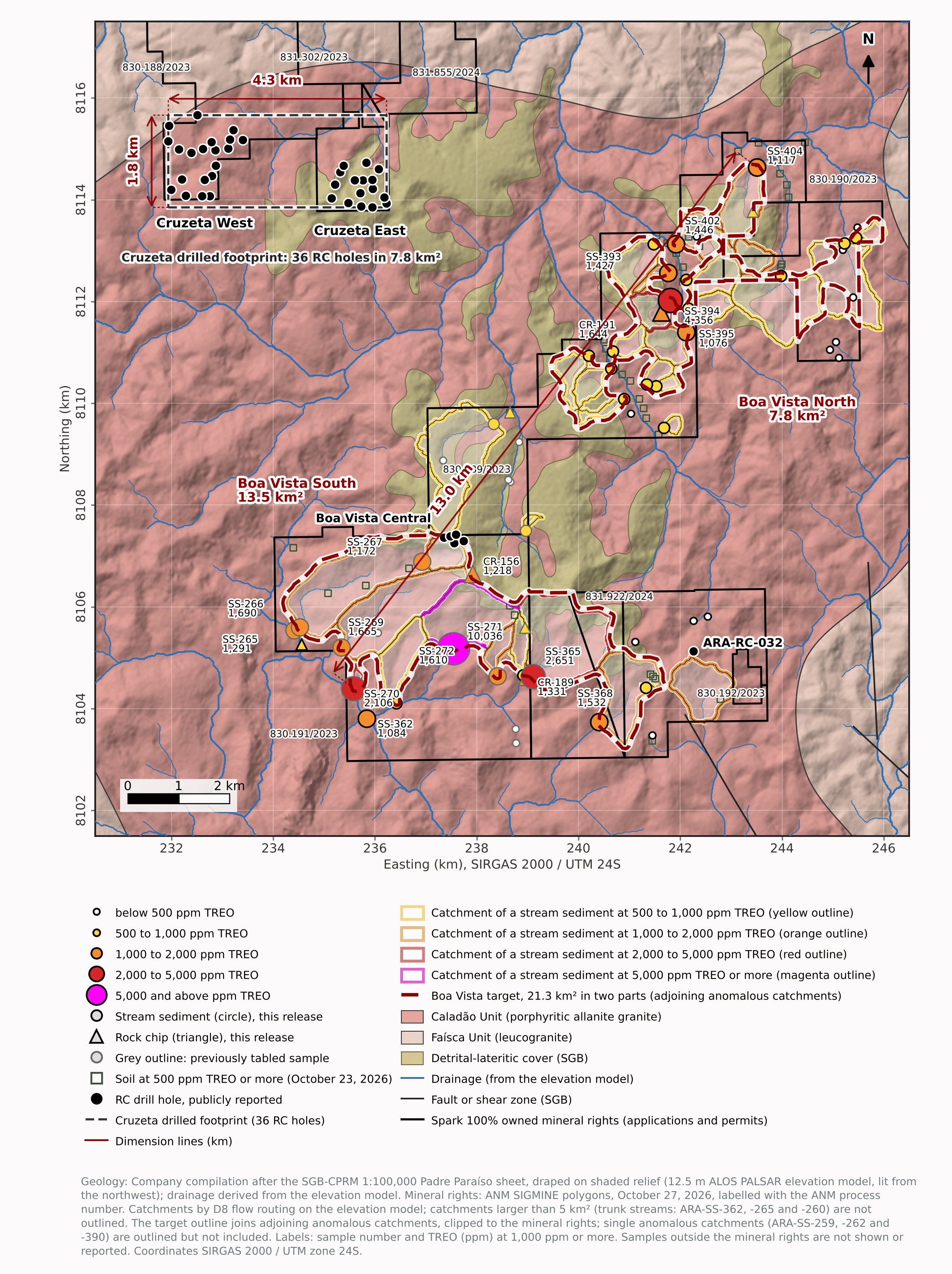
Figure 1. The Boa Vista target (dark red outline, 21.3 km² in two parts) with the 53 stream-sediment (circles) and eight rock-chip samples (triangles) classed by TREO, the catchment of every stream sediment at 500 ppm TREO or more (outline in the colour of its class; trunk streams above 5 km² not outlined), the 13.0 km trend from ARA-SS-270 to ARA-SS-404, the publicly reported RC drill holes, the drilled footprint of the 36 Cruzeta holes (dashed rectangle, 4.3 km by 1.8 km) and the soils of October 23, 2026 at 500 ppm TREO or more (open green squares), on the Company's geology compilation draped on shaded relief, with drainage, faults and the
To view an enhanced version of this graphic, please visit:
https://images.newsfilecorp.com/files/10093/322100_1efc1d7d44c0eaea_002full.jpg
The scale of the target is the point of the analysis. It runs for 13.0 km from ARA-SS-270 at its south-western tip to ARA-SS-404 at its north-eastern tip and spans up to 7 km across the trend; its two parts measure 7.5 km by 4.3 km and 6.5 km by 5.2 km. For comparison, the 36 holes at Cruzeta East and West lie within a footprint of about 4.3 km by 1.8 km, 7.8 km², and every one of them intersected a main interval at 500 ppm TREO or more. The Boa Vista target covers nearly three times that area, and Boa Vista South alone, at 13.5 km², is 1.7 times it. An area of anomalous drainage is not a mineralized area; it is the ground to be tested, and the test program below is sized to it.
Table 3. The Boa Vista target defined by the catchment analysis, and its two parts.
| Target and parts | Area (km²) | Extent (km) | Anomalous catchments (new samples) | Best sample, TREO (ppm) | MREO/TREO (%) | Mineral rights (ANM process) | Test |
| Boa Vista South (south-western part) | 13.5 | 7.5 × 4.3 | 11 (4 new) | ARA-SS-271, 10,036 (Sep 24, 2026) | 20.1 | 830.191/2023; 830.192/2023; 831.922/2024 | The first RC holes of the next campaign, beside the maiden holes |
| Boa Vista North (north-eastern part) | 7.8 | 6.5 × 5.2 | 17 (17 new) | ARA-SS-394, 4,356 (this release) | 18.8 | 830.189/2023; 830.190/2023 | RC holes on 400 m centres, after Boa Vista South |
| Boa Vista target | 21.3 | 13.0 (ARA-SS-270 to ARA-SS-404) | 28 (21 new) | ARA-SS-271, 10,036 | 19.5 | Five processes, | About 35 first-pass RC holes, about 1,750 m |
Area is the area of the outline as drawn in Figure 1 (the envelope of the adjoining anomalous catchments, clipped to the Company's mineral rights); the catchments themselves cover 17.7 km² of the outline (11.8 km² in Boa Vista South and 5.9 km² in Boa Vista North), the balance being the ground between adjoining catchments that the envelope encloses, and 2.2 km² of the Boa Vista North catchments that lie outside the mineral rights are excluded. Extent is the east-west by north-south size of each part and, for the target, the distance between the samples at its two tips, ARA-SS-270 and ARA-SS-404 (the outline itself is 13.7 km long along the trend). Anomalous catchments are those of stream sediments at 500 ppm TREO or more, excluding trunk streams; 3 single anomalous catchments (ARA-SS-259, -262 and -390) lie outside the outline. MREO/TREO is the ratio of the summed grades of the stream sediments. Mineral rights per the ANM SIGMINE polygons of October 27, 2026. First-pass RC holes are about 50 m deep on 400 m centres, subject to financing, access and the required permits. For comparison, the 36 Cruzeta East and West holes lie within about 4.3 km by 1.8 km (7.8 km²; the rectangle in Figure 1). The target is an area for further exploration, not an exploration target within the meaning of NI 43-101: no quantity or grade is implied (see Cautionary Statements).
The Target from South-west to North-east
Boa Vista South, the south-western part (13.5 km², 7.5 km east-west by 4.3 km north-south), wraps around the plateau drilled by the five maiden holes: it begins at the collars, extends 3.4 km west and 3.3 km south of them, and continues south-east along the slopes below the plateau to within 1 km of ARA-RC-032 (Figure 2). Seven catchments drain the southern and western slopes: ARA-SS-271 (10,036 ppm TREO,
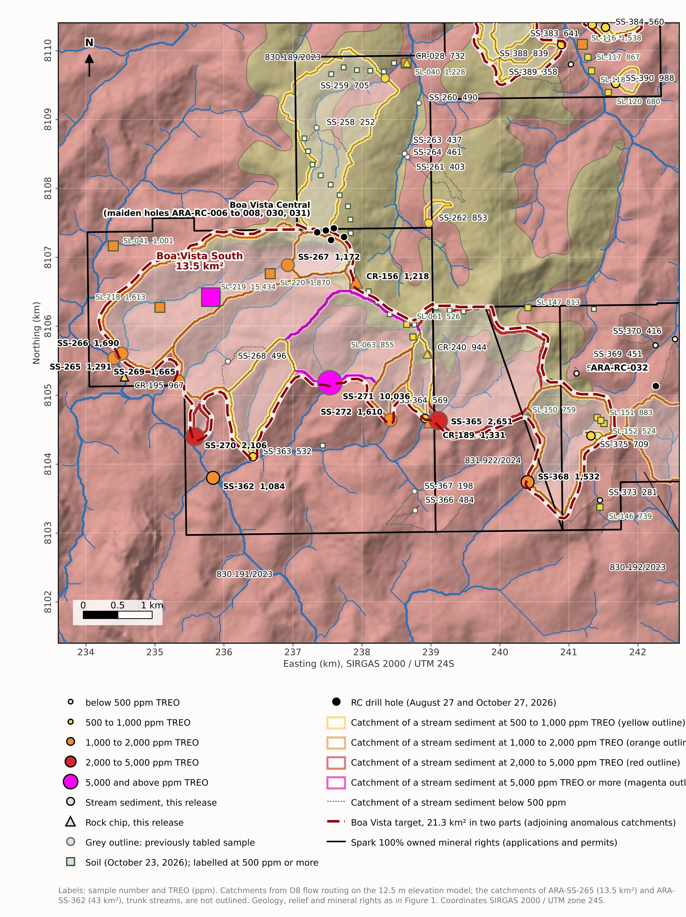
Figure 2. Boa Vista South and Boa Vista Central, the south-western part of the target: stream-sediment and rock-chip samples (circles and triangles) and the soils of October 23, 2026 (squares), all classed by TREO and labelled with their number and grade, the five maiden RC holes and ARA-RC-032, the catchments of the stream sediments at 500 ppm TREO or more (outline in the colour of their class) and below 500 ppm (grey dotted), and the target outline (dark red), on the geology, shaded relief and mineral rights of Figure 1.
To view an enhanced version of this graphic, please visit:
https://images.newsfilecorp.com/files/10093/322100_1efc1d7d44c0eaea_003full.jpg
The same ground holds the three strongest soils of the October 23, 2026 release, ARA-SL-218, -219 and -220, including the
Table 2. Boa Vista South and the drainages west of it: new samples at 500 ppm TREO or more.
| Sample | Medium | Catchment (km²) | TREO (ppm) | MREO/TREO (%) | NdPr (ppm) | Y₂O₃ (ppm) | Ga₂O₃ (g/t) |
| ARA-SS-368 | stream sediment, primary drainage | 1.28 | 1,532 | 23.1 | 339 | 44 | 47.0 |
| ARA-SS-362 | stream sediment, secondary drainage | 43 (trunk) | 1,084 | 18.3 | 187 | 45 | 52.4 |
| ARA-CR-195 | rock chip, Caladão Granite (grab) | n/a | 967 | 24.9 | 221 | 86 | 26.9 |
| ARA-SS-375 | stream sediment, primary drainage | 0.01 | 709 | 22.5 | 151 | 30 | 12.1 |
| ARA-SS-364 | stream sediment, primary drainage | 0.28 | 569 | 21.8 | 120 | 15 | 21.5 |
| ARA-SS-363 | stream sediment, primary drainage | 0.76 | 532 | 19.0 | 91 | 50 | 43.0 |
Catchment is the area upstream of the sample site on the 12.5 m elevation model. ARA-SS-368 and ARA-SS-375 lie 2.3 km and 1.2 km from ARA-RC-032 on the south-eastern slopes; ARA-SS-363 and -364 are in the south-western and south-eastern catchments of Boa Vista South; ARA-SS-362 is on the trunk stream west of the target (catchment 43 km², not part of the outline); ARA-CR-195 is a grab sample of Caladão Granite 1.7 km west of ARA-SL-219. MREO/TREO is the magnet rare earth share of TREO; NdPr is Nd₂O₃ + Pr₆O₁₁. Individual surface samples; not drill intervals. Rock chips are selective samples and may not be representative.
Boa Vista North, the north-eastern part (7.8 km², 6.5 km east-west by 5.2 km north-south), lies 4 to 10 km north-east of the maiden holes and 2 to 3 km east of the lateritic plateau (Figure 3). It is defined by 17 adjoining catchments, every one reported here for the first time (Table 1). The strongest are four first-order tributaries on the western flank of a north-flowing valley, 948 to 4,356 ppm TREO: ARA-SS-394 (4,356 ppm,
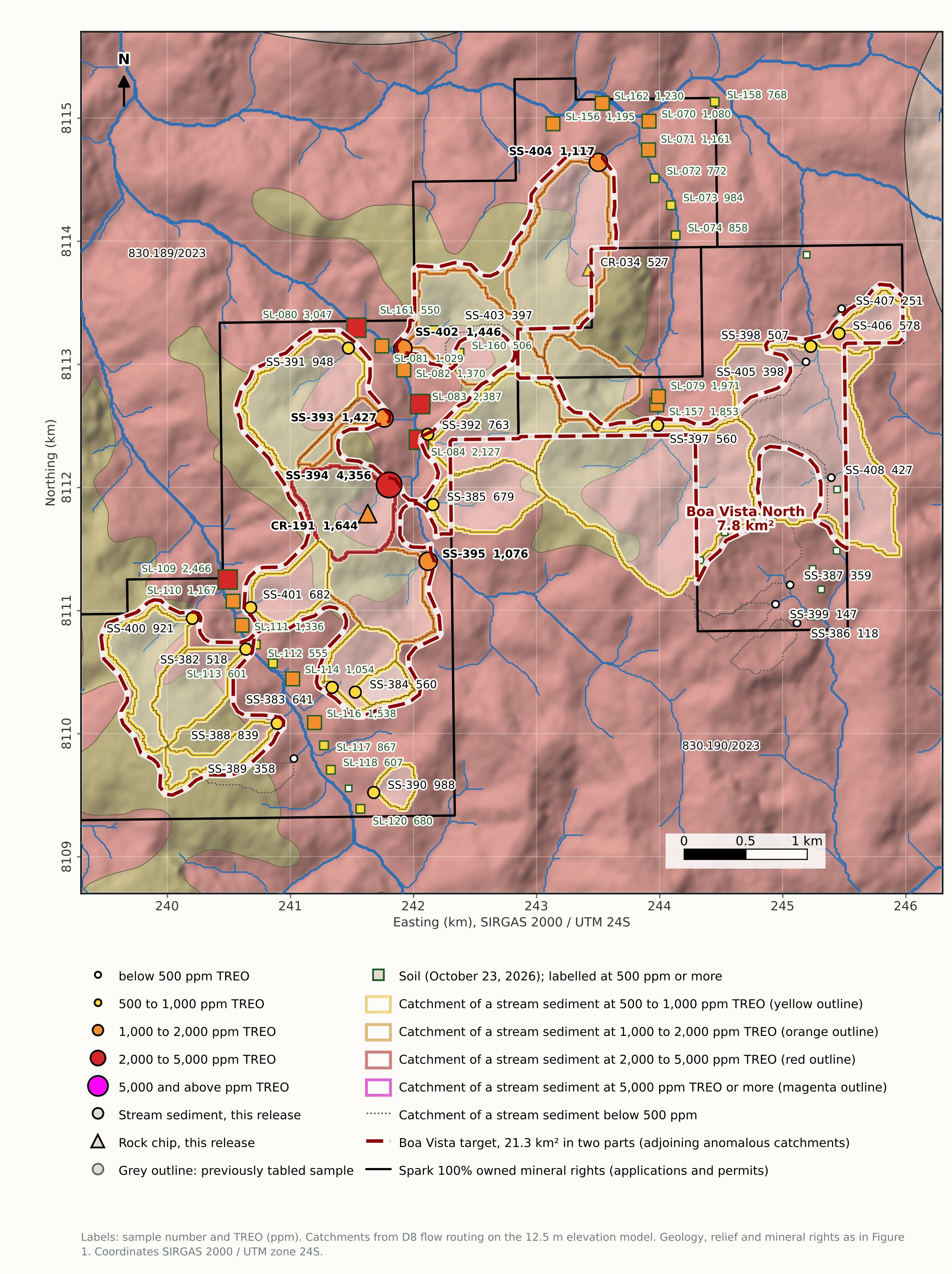
Figure 3. Boa Vista North, the north-eastern part of the target: stream-sediment and rock-chip samples of this news release (circles and triangles) and the soils of October 23, 2026 (squares), all classed by TREO and labelled with their number and grade, the catchments of the stream sediments at 500 ppm TREO or more (outline in the colour of their class) and below 500 ppm (grey dotted), and the target outline (dark red), on the geology, shaded relief and mineral rights of Figure 1.
To view an enhanced version of this graphic, please visit:
https://images.newsfilecorp.com/files/10093/322100_1efc1d7d44c0eaea_004full.jpg
Two other media agree. The saprolite sample ARA-CR-191, collected inside the catchment of ARA-SS-394, 300 m south-west of the site, returned 1,644 ppm TREO with
Table 1. Boa Vista North: the stream sediments at 500 ppm TREO or more and the saprolite sample, all reported in this news release.
| Sample | Medium | Catchment (km²) | TREO (ppm) | MREO/TREO (%) | NdPr (ppm) | Y₂O₃ (ppm) | Ga₂O₃ (g/t) |
| ARA-SS-394 | stream sediment, primary drainage | 0.46 | 4,356 | 22.1 | 928 | 106 | 44.4 |
| ARA-CR-191 | rock chip, saprolite with feldspar and biotite | n/a | 1,644 | 26.4 | 414 | 68 | 43.0 |
| ARA-SS-402 | stream sediment, secondary drainage | 0.65 | 1,446 | 18.4 | 258 | 29 | 55.1 |
| ARA-SS-393 | stream sediment, primary drainage | 0.09 | 1,427 | 22.8 | 313 | 40 | 41.7 |
| ARA-SS-404 | stream sediment, primary drainage | 0.86 | 1,117 | 22.8 | 241 | 49 | 55.1 |
| ARA-SS-395 | stream sediment, secondary drainage | 0.47 | 1,076 | 10.7 | 111 | 16 | 61.8 |
| ARA-SS-390 | stream sediment, primary drainage | 0.08 (single) | 988 | 7.0 | 66 | 10 | 63.2 |
| ARA-SS-391 | stream sediment, primary drainage | 0.64 | 948 | 20.1 | 182 | 32 | 25.5 |
| ARA-SS-400 | stream sediment, primary drainage | 0.37 | 921 | 14.3 | 123 | 31 | 36.3 |
| ARA-SS-388 | stream sediment, primary drainage | 0.17 | 839 | 14.4 | 114 | 27 | 45.7 |
| ARA-SS-392 | stream sediment, primary drainage | 0.56 | 763 | 18.4 | 134 | 19 | 28.2 |
| ARA-SS-401 | stream sediment, primary drainage | 0.25 | 682 | 13.1 | 83 | 28 | 40.3 |
| ARA-SS-385 | stream sediment, primary drainage | 0.37 | 679 | 14.0 | 91 | 16 | 40.3 |
| ARA-SS-383 | stream sediment, secondary drainage | 0.32 | 641 | 20.7 | 127 | 19 | 36.3 |
| ARA-SS-406 | stream sediment, primary drainage | 0.14 | 578 | 21.9 | 120 | 23 | 34.9 |
| ARA-SS-397 | stream sediment, secondary drainage | 1.66 | 560 | 13.5 | 71 | 17 | 52.4 |
| ARA-SS-384 | stream sediment, primary drainage | 0.10 | 560 | 18.8 | 101 | 16 | 20.2 |
| ARA-SS-382 | stream sediment, primary drainage | 0.33 | 518 | 15.5 | 76 | 18 | 32.3 |
| ARA-SS-398 | stream sediment, primary drainage | 1.55 | 507 | 19.7 | 94 | 21 | 59.1 |
Catchment is the area upstream of the sample site on the 12.5 m elevation model (for ARA-SS-402, the whole catchment including the part excluded from the outline); "single" marks ARA-SS-390, whose catchment adjoins no other anomalous catchment and lies outside the outline. MREO/TREO is the magnet rare earth share of TREO; NdPr is Nd₂O₃ + Pr₆O₁₁. Individual surface samples; not drill intervals. Rock chips are selective samples and may not be representative.
How the Target Will Be Tested
The target will be tested by RC drilling. The following program is planned, subject to field conditions, financing and the required permits and access permissions (see Cautionary Statements on Exploration Results and the Cautionary Statement Regarding Forward-Looking Information below):
First-pass RC drilling across the target: about 35 holes, about 50 m deep, on 400 m centres (about 1,750 m), sited on the slopes where the rare earth zone is interpreted to be exposed, with the collar positions set from the catchment analysis, the soils of October 23, 2026 and access.
The first holes go into Boa Vista South, beside the maiden holes, around ARA-SS-271 and ARA-SL-219, as the first holes of the next drilling campaign; Boa Vista North, around ARA-SS-394 and ARA-CR-191, follows.
Infill to 200 m centres where the first-pass holes confirm the zone, and step-out and infill holes around the five maiden holes at Boa Vista Central.
Results from the remaining Arapaima targets will be reported as the database review is completed.
Supply Context
China accounted for
Technical Notes & Reporting Basis
TREO is the sum of La₂O₃, CeO₂, Pr₆O₁₁, Nd₂O₃, Sm₂O₃, Eu₂O₃, Gd₂O₃, Tb₄O₇, Dy₂O₃, Ho₂O₃, Er₂O₃, Tm₂O₃, Yb₂O₃, Lu₂O₃ and Y₂O₃. MREO (magnet rare earth oxides) is Nd₂O₃ + Pr₆O₁₁ + Dy₂O₃ + Tb₄O₇; NdPr is Nd₂O₃ + Pr₆O₁₁. MREO and NdPr are included within TREO and must not be added to it; MREO/TREO is calculated for each sample from the oxide sums and, where a group of samples is described, as the ratio of the summed grades. Ga₂O₃ = Ga × 1.3442; Li₂O = Li × 2.1525; Nb₂O₅ = Nb × 1.4305; Sc₂O₃ = Sc × 1.5338; Y₂O₃ = Y × 1.2699. One g/t equals one ppm. Oxide values are calculated analytical equivalents of the elemental assays, not recoverable products, and gallium oxide values are not elemental gallium grades.
Results below the detection limit are reported as "<" followed by the detection limit converted to oxide and are not substituted; where a component of a sum is below the detection limit, the sum is calculated with that component at the detection limit and reported with "<".
"Mineralization" and "anomalous" in this news release mean values above 500 ppm TREO or 50 g/t Ga₂O₃ in an individual sample; these thresholds are reporting conventions of the Company, not economic cut-offs. "Target" and "part" mean an area, defined by the adjoining catchments of anomalous stream sediments, within which the material that produced the anomalies is interpreted to occur; they imply no quantity or grade.
Catchments were delineated from the ALOS PALSAR radiometrically terrain-corrected elevation model (12.5 m cells) by D8 flow routing after pit filling, depression filling and flat resolution, with each sample site snapped to the nearest channel cell within 90 m of its GPS position. Catchments of anomalous samples were grouped where they adjoin (share a divide, or are separated by less than about 340 m of valley floor); a group of two or more catchments forms a part of the target, and the outline is the group's envelope clipped to the Company's mineral rights. The method locates the area that drains to a site; it does not locate the source within that area. Catchment areas are given to two decimals but are no more accurate than the elevation model and the site positions allow, about ±
The Appendix lists every stream-sediment and rock-chip sample collected in the Boa Vista area within the Company's mineral rights, including samples below the reporting thresholds and the 24 samples tabled in the news releases of September 24, 2026 and October 17, 2025, with coordinates, catchment area, mineral right, sample type and the field description of the sampled material. Five stream sediments collected in the same programs (ARA-SS-144, -371, -372, -376 and -396) plot outside the Company's mineral rights in the ANM SIGMINE layer of October 27, 2026 and are not reported; ARA-SS-372 plots 10 m outside the boundary of process 830.192/2023, within the accuracy of its GPS position, and is excluded on the same rule. The September 24, 2026 release referred to 58 stream-sediment and seven rock-chip samples; the database review assigned one further rock chip (ARA-CR-034, tabled on October 17, 2025) to the area.
The Boa Vista samples lie on five ANM processes (830.189/2023, 830.190/2023, 830.191/2023, 830.192/2023 and 831.922/2024), exploration permits and exploration applications held of record by Canopus Geologia e Projetos Ltda. as nominee for the Company under a technical services and mineral rights custody agreement; the Company holds
Sampling, Analysis & Quality Control
Stream-sediment samples were collected by Company geologists from active drainage channels, classified in the field as primary (28 samples), secondary (9) and tertiary (16) drainages, and were sieved in the field at 60 mesh (250 µm) or finer; the sampled material is described in Appendix Table A1. Rock-chip samples were collected from exposed fresh or weathered rock and are selective by nature. Sample locations were recorded with handheld GPS units in SIRGAS 2000 UTM Zone 24S; the horizontal accuracy of individual readings was not recorded and is typically within 3 to 10 m for such units.
Samples were prepared and analyzed by SGS Geosol Laboratórios S.A. (SGS Geosol Laboratórios Ltda. for the 2025 batches) in Vespasiano, Minas Gerais, Brazil, a commercial laboratory that is independent of the Company and is ISO 9001:2015 and ISO 14001:2015 certified. Preparation (PRP70J_A2) comprised drying at 105 °C, crushing to
Qualified Persons & Data Verification
Jonathan Victor Hill, BSc (Hons), FAusIMM, VP Exploration, Country Manager and Director, and Dr. Fernando Tallarico, P.Geo., FSEG, Chief Executive Officer and Chairman, are Qualified Persons as defined in National Instrument 43-101, Standards of Disclosure for Mineral Projects. They have prepared or supervised the preparation of the scientific and technical information in this news release, including the catchment analysis and the interpretations, and have reviewed and approved it. Neither is independent of the Company.
The Qualified Persons have verified the data disclosed, including the sampling, analytical and test data underlying the information and opinions in this news release, by comparing every value in the text, tables and Appendix against the SGS Geosol certificates of analysis (61 samples in seven certificates; all element values match and the derived oxide values agree within rounding of the last digit); reviewing the laboratory quality-control results for the batches reported; checking the sample identifiers, coordinates and field descriptions against the field records; checking each sample position against the ANM SIGMINE polygons of October 27, 2026; verifying the catchment delineation against the drainage network of the SGB 1:100,000 sheet and the shaded relief; and reviewing the chain of custody from the field to the laboratory. The verification is subject to the following limitations: the samples were collected by Company personnel; no independent sampling, resampling or check analysis at a second laboratory has been undertaken; sample coordinates are handheld GPS readings; the elevation model has not been checked against ground survey; and the Qualified Persons have not independently audited the laboratory's internal procedures beyond its certification and quality-control record.
Cautionary Statements on Exploration Results
Early-stage results. The results in this news release come from reconnaissance surface sampling: 53 stream-sediment and eight rock-chip samples in the Boa Vista area, of which 35 and two are reported for the first time. They are individual samples, not drill intersections, channel averages or composite grades. They are preliminary, and they are not conclusive evidence of the presence or absence of an economic deposit.
Limitations of surface samples and of the catchment analysis. Stream sediments integrate material transported from the upstream catchment and do not locate or grade a source within it; a catchment outline shows where the source may be, not where it is. Rock chips are selective and may not represent the average grade of the outcrop or rock unit sampled. Soils were collected along access routes rather than on a regular grid. The target is defined from the sample positions, the elevation model, the Company's reporting threshold and the grouping rule described in the Technical Notes; a different threshold, elevation model or rule would give a different outline and area, and the area of the target is not a measure of mineralization. The comparison with the Cruzeta drilled footprint compares an area of anomalous drainage with an area of drilling; it does not imply that the target is mineralized throughout, or that it will support the same results as the Cruzeta holes. No sample in this news release establishes the continuity, thickness, extent or grade of mineralization at depth or between sample points, and continuity between the surface samples and the drill holes, or between the two parts of the target, has not been demonstrated.
Interpretations. The statements that the two parts of the target are exposures of the rare earth zone intersected in the Boa Vista drill holes and in ARA-RC-032, that the drainage, soil and saprolite samples in Boa Vista North sample that zone, that the six small catchments in the south-west of Boa Vista North reflect the gallium-rich upper horizon, that the anomalous samples at both ends of the trend show that the target is not closed off, and that the exploration model developed at Cruzeta applies in the Boa Vista area, are interpretations of the Qualified Persons based on the field descriptions, the assay results, the drill results and the topography. They have not been tested by drilling or trenching at the sample sites and may change as work proceeds. The comparison of magnet rare earth shares between surface samples and drill composites does not imply that the surface samples are representative of the zone at depth. A single sample does not establish a grade.
Terminology. "Discovery", "target", "part", "zone", "horizon", "catchment", "model" and "mineralization" are used in their exploration sense and do not mean that a mineral resource or mineral reserve has been identified. No mineral resource or mineral reserve has been estimated for any part of the Arapaima Project. The Company is not disclosing an exploration target within the meaning of NI 43-101, and no potential quantity or grade should be inferred from the sample counts, thresholds, target area or maps in this news release. No preliminary economic assessment or other economic analysis has been completed. There is no certainty that further work will define a mineral resource or that any mineral resource, if defined, can be extracted economically.
Mineralogy and recovery. The rare earth mineralization at Arapaima is interpreted as ionic adsorption clay (IAC) style, but this has not been confirmed. The analytical method is a total digestion and does not measure the proportion of the rare earths, or of the gallium, that is ionically adsorbed or otherwise recoverable. No metallurgical test result has been reported for any element from Arapaima and no recovery has been demonstrated.
Mineral rights. The planned work is subject to the permits, authorizations and landowner access required under Brazilian law, and the filings with the ANM for the assignment, extension and grant of the Boa Vista processes described in the Technical Notes are pending.
Market information. The statements under Supply Context are drawn from the public sources named there, as of their stated dates; the Company has not independently verified them, and they may change. They are provided for context and are not a representation that any mineral at Arapaima will be produced or sold.
Previously disclosed information. The surface results in this news release have not been disclosed before, except the 24 samples tabled on September 24, 2026 and October 17, 2025, which are repeated in the Appendix for completeness with their values as recorded in the Company's database, and the yttrium oxide values of the surface samples (October 20, 2026), which are included in the TREO values reported here. The drill, soil and road-cut results referred to for context were reported on August 27, October 8, October 23 and October 27, 2026. Previously reported assay results are unchanged.
Cautionary Note to United States Investors
This news release uses terms defined in NI 43-101 and the CIM Definition Standards for Mineral Resources and Mineral Reserves. The Company's securities are quoted on the OTC Pink market in the United States. United States investors are cautioned that these terms, and the disclosure requirements of NI 43-101, differ from those of the United States Securities and Exchange Commission under subpart 1300 of Regulation S-K, and that the information in this news release has not been prepared in accordance with United States standards. No mineral resource or mineral reserve has been estimated under either standard.
About Spark Energy Minerals Inc.
Spark Energy Minerals Inc. is a Canadian critical minerals exploration company whose principal asset, the Arapaima Project, comprises approximately 91,900 hectares across several municipalities in the Lithium Valley region of Minas Gerais, Brazil. The Company has made gallium and rare earth element discoveries at Cruzeta and Boa Vista, where mineralization is hosted in ionic adsorption clays developed over the Caladão Granite. Lithium-bearing pegmatites are a secondary target on the property. The Company also holds the Seridó Project in the Seridó tungsten district of Rio Grande do Norte, where tungsten-focused reconnaissance exploration is underway, and the Solonópole Project in Ceará.
For further information
Spark Energy Minerals Inc. | Dr. Fernando Tallarico, P.Geo., FSEG, Chief Executive Officer and Chairman
Email: connect@sparkminerals.co | Tel: +1-877-272-9226 | www.sparkminerals.co
On behalf of the Board of Directors of Spark Energy Minerals Inc.
Neither the Canadian Securities Exchange nor its Regulation Services Provider accepts responsibility for the adequacy or accuracy of this release.
Cautionary Statement Regarding Forward-Looking Information
This news release contains forward-looking information within the meaning of applicable Canadian securities legislation, including National Instrument 51-102. Forward-looking information in this news release includes, without limitation: the interpretation that the two parts of the Boa Vista target are exposures of the rare earth zone intersected in the Boa Vista drill holes and in ARA-RC-032 and that the drainage, soil and saprolite samples there sample that zone; the interpretation of the six small catchments in the south-west of Boa Vista North and of the exploration model developed at Cruzeta; the characterization of samples as anomalous and of areas as a target or parts of it; the comparison of the size of the target with the drilled footprint at Cruzeta and the statements that the Boa Vista target is substantially larger, is not closed off and opens a new target area for RC drilling; the planned RC drilling, including the number, spacing, depth, sequence and timing of planned holes and the intention to site them where the rare earth zone is interpreted to be exposed; the expectation that the permits and authorizations required for the planned work will be obtained; the planned reporting of results from other targets; statements about the supply of, demand for and trade in rare earths and gallium and about the Company's potential role as a source of supply outside China; and any statement about what further work may show, find or confirm. Words such as "interpreted", "planned", "will", "intends", "expects", "offers", "potential" and "may" identify forward-looking information.
Forward-looking information is based on the following material factors and assumptions: that the samples, field descriptions and SGS Geosol analyses are accurate and representative of the material sampled; that the elevation model and the catchment delineation are adequate for the purpose of defining the target; that the geological interpretations of the Qualified Persons, including the vertical zonation of gallium above rare earths and its relationship to topography, are correct; that the Company will obtain the financing required for the planned work on acceptable terms and in time for the planned schedule; that the Company's mineral rights remain in good standing, that the pending filings with the ANM for the assignment, extension and grant of the Boa Vista processes will be completed, and that the permits, authorizations and landowner, environmental and other access permissions required for the planned work will be obtained in the ordinary course; that drilling and laboratory contractors will be available; that weather and field conditions will allow the work to proceed; and that the public information on rare earth and gallium supply and trade cited in this news release is accurate.
Actual results may differ materially from those expressed or implied by the forward-looking information because of risks that include: the inherent uncertainty of mineral exploration, including the risk that drilling does not confirm the interpretations, the target outline, the continuity or the values reported here; the risk that individual sample results, including the highest values, are not reproduced by closer-spaced work; the risk that the rare earth and gallium mineralization is not of ionic adsorption clay style, is not continuous, or is not amenable to economic recovery; the risk that no mineral resource is ever defined; metallurgical risk; the availability and cost of financing and the dilution that equity financing causes; the risk that permits or authorizations required for the planned work are delayed, refused or granted with conditions; commodity-price and trade-policy risk for rare earths and gallium, including the concentration of supply in a small number of countries and changes in export controls and in the demand for supply from outside China; errors in the Company's exploration database or in the elevation model; title, permitting, environmental, community, regulatory and political risks in Brazil; and the other risks described in the Company's filings on SEDAR+ at www.sedarplus.ca. Forward-looking information is provided as of the date of this news release for the purpose of describing the Company's current expectations and plans, and readers are cautioned not to place undue reliance on it. The Company does not undertake to update forward-looking information except as required by law.
Appendix: Complete Stream-Sediment and Rock-Chip Results, Boa Vista Area
All stream-sediment and rock-chip samples collected in the Boa Vista area within the Company's mineral rights, including those below the reporting thresholds and those tabled previously (last column). Coordinates in SIRGAS 2000 UTM Zone 24S (handheld GPS). Catchment is the area upstream of the site on the 12.5 m elevation model (trunk streams above 5 km² are marked). Mineral right is the ANM process on which the sample plots (October 27, 2026). Material is the field description recorded at collection. Values below the detection limit are shown as "<" followed by the detection limit converted to oxide. Scandium is reported as Sc₂O₃ = Sc × 1.5338.
Table A1. Boa Vista area: all 53 stream-sediment samples, sorted by TREO (highest first).
| Sample | Easting | Northing | Drainage (field) | Material | Catchment (km²) | TREO (ppm) | MREO/ TREO (%) | NdPr (ppm) | Ga₂O₃ (g/t) | Sc₂O₃ (g/t) | Nb₂O₅ (ppm) | Mineral right | Reported |
| ARA-SS-271 | 237536 | 8105184 | Tertiary | Clay | 1.66 | 10,036 | 22.4 | 2,178 | 43.0 | 23.0 | 978 | 830.191/2023 | Sep 24, 2026; Oct 17, 2025 |
| ARA-SS-394 | 241804 | 8112023 | Primary | Fine sand | 0.46 | 4,356 | 22.1 | 928 | 44.4 | 13.8 | 73 | 830.189/2023 | This release |
| ARA-SS-365 | 239105 | 8104633 | Tertiary | Clay | 2.43 | 2,651 | 20.7 | 530 | 79.3 | 13.8 | 156 | 831.922/2024 | Sep 24, 2026 |
| ARA-SS-270 | 235576 | 8104398 | Tertiary | Clay | 0.06 | 2,106 | 19.7 | 394 | 39.0 | 15.3 | 203 | 830.191/2023 | Oct 17, 2025 |
| ARA-SS-266 | 234517 | 8105602 | Tertiary | Clay | 3.14 | 1,690 | 14.2 | 224 | 68.6 | 26.1 | 239 | 830.191/2023 | Oct 17, 2025 |
| ARA-SS-269 | 235335 | 8105205 | Tertiary | Clay | 2.16 | 1,665 | 18.5 | 287 | 60.5 | 12.3 | 136 | 830.191/2023 | Oct 17, 2025 |
| ARA-SS-272 | 238411 | 8104642 | Tertiary | Clay | 0.27 | 1,610 | 17.8 | 275 | 64.5 | 13.8 | 134 | 830.191/2023 | Sep 24, 2026; Oct 17, 2025 |
| ARA-SS-368 | 240402 | 8103739 | Primary | Clay and medium sand | 1.28 | 1,532 | 23.1 | 339 | 47.0 | <7.7 | 59 | 831.922/2024 | This release |
| ARA-SS-402 | 241915 | 8113130 | Secondary | Clay and fine sand | 0.65 | 1,446 | 18.4 | 258 | 55.1 | 10.7 | 70 | 830.189/2023 | This release |
| ARA-SS-393 | 241760 | 8112566 | Primary | Clay | 0.09 | 1,427 | 22.8 | 313 | 41.7 | 9.2 | 49 | 830.189/2023 | This release |
| ARA-SS-265 | 234408 | 8105539 | Tertiary | Clay | 14 (trunk) | 1,291 | 15.6 | 187 | 51.1 | 21.5 | 309 | 830.191/2023 | Oct 17, 2025 |
| ARA-SS-267 | 236926 | 8106890 | Tertiary | Clay | 0.42 | 1,172 | 7.7 | 82 | 67.2 | 19.9 | 296 | 830.191/2023 | Oct 17, 2025 |
| ARA-SS-404 | 243503 | 8114641 | Primary | Clay and orange sludge | 0.86 | 1,117 | 22.8 | 241 | 55.1 | 13.8 | 72 | 830.189/2023 | This release |
| ARA-SS-362 | 235840 | 8103804 | Secondary | Clay | 43 (trunk) | 1,084 | 18.3 | 187 | 52.4 | 16.9 | 109 | 830.191/2023 | This release |
| ARA-SS-395 | 242120 | 8111400 | Secondary | Clay | 0.47 | 1,076 | 10.7 | 111 | 61.8 | 16.9 | 72 | 830.189/2023 | This release |
| ARA-SS-390 | 241676 | 8109523 | Primary | Clay | 0.08 | 988 | 7.0 | 66 | 63.2 | 15.3 | 53 | 830.189/2023 | This release |
| ARA-SS-391 | 241472 | 8113133 | Primary | Fine and medium sand | 0.64 | 948 | 20.1 | 182 | 25.5 | <7.7 | 36 | 830.189/2023 | This release |
| ARA-SS-400 | 240205 | 8110939 | Primary | Clay and medium sand | 0.37 | 921 | 14.3 | 123 | 36.3 | 10.7 | 501 | 830.189/2023 | This release |
| ARA-SS-262 | 238966 | 8107497 | Tertiary | Clay | 0.05 | 853 | 2.6 | 17 | 64.5 | 16.9 | 532 | 830.189/2023 | Sep 24, 2026; Oct 17, 2025 |
| ARA-SS-388 | 240893 | 8110086 | Primary | Clay and fine sand | 0.17 | 839 | 14.4 | 114 | 45.7 | 13.8 | 179 | 830.189/2023 | This release |
| ARA-SS-392 | 242117 | 8112432 | Primary | Clay and fine sand | 0.56 | 763 | 18.4 | 134 | 28.2 | 7.7 | 54 | 830.189/2023 | This release |
| ARA-SS-375 | 241321 | 8104414 | Primary | Fine and medium sand | 0.01 | 709 | 22.5 | 151 | 12.1 | <7.7 | 29 | 830.192/2023 | This release |
| ARA-SS-259 | 238335 | 8109601 | Tertiary | Clay | 2.19 | 705 | 13.5 | 87 | 67.2 | 19.9 | 233 | 830.189/2023 | Sep 24, 2026; Oct 17, 2025 |
| ARA-SS-401 | 240678 | 8111025 | Primary | Medium sand | 0.25 | 682 | 13.1 | 83 | 40.3 | 15.3 | 422 | 830.189/2023 | This release |
| ARA-SS-385 | 242157 | 8111863 | Primary | Clay and sand | 0.37 | 679 | 14.0 | 91 | 40.3 | 9.2 | 73 | 830.189/2023 | This release |
| ARA-SS-383 | 241338 | 8110376 | Secondary | Clay | 0.32 | 641 | 20.7 | 127 | 36.3 | 9.2 | 72 | 830.189/2023 | This release |
| ARA-SS-406 | 245456 | 8113253 | Primary | Medium sand | 0.14 | 578 | 21.9 | 120 | 34.9 | <7.7 | 49 | 830.190/2023 | This release |
| ARA-SS-364 | 238916 | 8104661 | Primary | Medium sand | 0.28 | 569 | 21.8 | 120 | 21.5 | <7.7 | 56 | 830.191/2023 | This release |
| ARA-SS-397 | 243982 | 8112507 | Secondary | Clay and fine sand | 1.66 | 560 | 13.5 | 71 | 52.4 | 18.4 | 74 | 830.190/2023 | This release |
| ARA-SS-384 | 241529 | 8110339 | Primary | Sand and Clay | 0.10 | 560 | 18.8 | 101 | 20.2 | <7.7 | 29 | 830.189/2023 | This release |
| ARA-SS-363 | 236419 | 8104107 | Primary | Fine Sand | 0.76 | 532 | 19.0 | 91 | 43.0 | <7.7 | 77 | 830.191/2023 | This release |
| ARA-SS-382 | 240640 | 8110686 | Primary | Clay and fine sand | 0.33 | 518 | 15.5 | 76 | 32.3 | 7.7 | 172 | 830.189/2023 | This release |
| ARA-SS-398 | 245229 | 8113147 | Primary | Clay | 1.55 | 507 | 19.7 | 94 | 59.1 | 9.2 | 60 | 830.190/2023 | This release |
| ARA-SS-268 | 236054 | 8105492 | Tertiary | Clay | 0.21 | 496 | 10.8 | 46 | 65.9 | 15.3 | 216 | 830.191/2023 | Oct 17, 2025 |
| ARA-SS-260 | 238825 | 8109242 | Tertiary | Clay | 5 (trunk) | 490 | 3.9 | 14 | 82.0 | 23.0 | 240 | 830.189/2023 | Sep 24, 2026; Oct 17, 2025 |
| ARA-SS-366 | 238772 | 8103328 | Primary | Fine Sand | 0.03 | 484 | 19.9 | 92 | 36.3 | <7.7 | 49 | 830.191/2023 | Sep 24, 2026 |
| ARA-SS-264 | 238617 | 8108505 | Tertiary | Clay | 4.39 | 461 | 14.4 | 58 | 65.9 | 16.9 | 748 | 830.189/2023 | Sep 24, 2026; Oct 17, 2025 |
| ARA-SS-369 | 242258 | 8105726 | Primary | Clay | 0.18 | 451 | 22.5 | 96 | 57.8 | <7.7 | 47 | 830.192/2023 | This release |
| ARA-SS-263 | 238617 | 8108513 | Tertiary | Clay | 4.40 | 437 | 16.4 | 66 | 64.5 | 13.8 | 268 | 830.189/2023 | Sep 24, 2026; Oct 17, 2025 |
| ARA-SS-408 | 245394 | 8112080 | Secondary | Clay and sand | 0.36 | 427 | 22.0 | 89 | 26.9 | <7.7 | 53 | 830.190/2023 | This release |
| ARA-SS-370 | 242538 | 8105816 | Secondary | Clay and fine sand | 0.61 | 416 | 19.8 | 78 | 61.8 | 7.7 | 41 | 830.192/2023 | This release |
| ARA-SS-261 | 238658 | 8108459 | Tertiary | Clay | 0.14 | 403 | 4.8 | 14 | 83.3 | 24.5 | 546 | 830.189/2023 | Sep 24, 2026; Oct 17, 2025 |
| ARA-SS-405 | 245190 | 8113023 | Primary | Sandy-clayey | 0.24 | 398 | 19.7 | 74 | 32.3 | <7.7 | 63 | 830.190/2023 | This release |
| ARA-SS-403 | 242320 | 8113279 | Primary | Clay and fine sand | 0.29 | 397 | 16.7 | 62 | 30.9 | <7.7 | 47 | 830.189/2023 | This release |
| ARA-SS-387 | 245059 | 8111209 | Secondary | Fine sand and clay | 0.47 | 359 | 21.8 | 73 | 30.9 | <7.7 | 69 | 830.190/2023 | This release |
| ARA-SS-389 | 241028 | 8109799 | Primary | Clay and medium sand | 0.13 | 358 | 7.1 | 23 | 41.7 | 15.3 | 139 | 830.189/2023 | This release |
| ARA-SS-373 | 241448 | 8103475 | Primary | Clay | 0.53 | 281 | 20.8 | 54 | 43.0 | <7.7 | 40 | 830.192/2023 | This release |
| ARA-SS-258 | 237340 | 8108884 | Tertiary | Clay | 0.76 | 252 | 13.1 | 27 | 65.9 | 21.5 | 462 | 830.189/2023 | Sep 24, 2026; Oct 17, 2025 |
| ARA-SS-407 | 245479 | 8113455 | Primary | Clay | 0.03 | 251 | 19.3 | 45 | 49.7 | <7.7 | 39 | 830.190/2023 | This release |
| ARA-SS-374 | 241110 | 8105317 | Primary | Clay and coarse sand | 0.00 | 247 | 8.9 | 21 | 60.5 | 9.2 | 62 | 830.192/2023 | This release |
| ARA-SS-367 | 238760 | 8103606 | Secondary | Clay | 0.39 | 198 | 17.8 | 33 | 64.5 | <7.7 | 27 | 830.191/2023 | Sep 24, 2026 |
| ARA-SS-399 | 244943 | 8111054 | Primary | Clay | 0.11 | 147 | 16.0 | 21 | 55.1 | <7.7 | 36 | 830.190/2023 | This release |
| ARA-SS-386 | 245116 | 8110898 | Primary | Clay and fine sand | 0.13 | 118 | 19.2 | 21 | 33.6 | <7.7 | 30 | 830.190/2023 | This release |
"Reported" gives the date of the news release in which the sample was first tabled; "This release" marks the 37 samples reported for the first time. The values of previously tabled samples are as recorded in the Company's verified database and may differ by rounding from the earlier tables.
Table A2. Boa Vista area: all eight rock-chip samples, sorted by TREO (highest first).
| Sample | Easting | Northing | Field description | TREO (ppm) | MREO/ TREO (%) | NdPr (ppm) | Ga₂O₃ (g/t) | Sc₂O₃ (g/t) | Nb₂O₅ (ppm) | Li₂O (ppm) | Mineral right | Reported |
| ARA-CR-191 | 241627 | 8111788 | Saprolite with feldspar and biotite | 1,644 | 26.4 | 414 | 43.0 | 9.2 | 51 | 103 | 830.189/2023 | This release |
| ARA-CR-189 | 238985 | 8104622 | Blocks of nearly pure kaolin containing medium-sized quartz crystals, occurring together with quartz boulders up to approximately 0.5 m in diameter, suggesting a possible upstream pegmatitic source. | 1,331 | 16.1 | 206 | 59.1 | 12.3 | 122 | 67 | 830.191/2023 | Sep 24, 2026 |
| ARA-CR-156 | 237916 | 8106647 | Porphyritic granitic rock containing amphibole; 0.34 µSv/h | 1,218 | 23.2 | 267 | 33.6 | <7.7 | 72 | 34 | 830.191/2023 | Sep 24, 2026 |
| ARA-CR-195 | 234557 | 8105268 | Caladão Granite | 967 | 24.9 | 221 | 26.9 | 32.2 | 100 | 45 | 830.191/2023 | This release |
| ARA-CR-240 | 238947 | 8105597 | Representative sample of unweathered charnockite outcrop for whole-rock geochemical analysis | 944 | 20.6 | 185 | 25.5 | <7.7 | 66 | 50 | 830.191/2023 | Sep 24, 2026 |
| ARA-CR-028 | 238652 | 8109824 | Porphyritic, coarse-grained granite containing amphibole; 0.42 µSv/h | 732 | 28.1 | 188 | 37.6 | 15.3 | 84 | 37 | 830.189/2023 | Sep 24, 2026 |
| ARA-CR-034 | 243419 | 8113768 | Granite with orthoclase feldspar | 527 | 20.4 | 100 | 32.3 | 9.2 | 69 | 267 | 830.189/2023 | Oct 17, 2025 |
| ARA-CR-151 | 237916 | 8106647 | Pegmatite composed of qz, fk, white mica and tour | <21 | >17.5 | 3 | 20.2 | <7.7 | <14 | 62 | 830.191/2023 | Sep 24, 2026 |

To view the source version of this press release, please visit https://www.newsfilecorp.com/release/322100
FAQ
AI-generated questions and answers. How Rhea-AI works. Not financial advice.
How large is Spark Energy Minerals' Boa Vista rare earth target?
The Boa Vista exploration area covers 21.3 km² along a 13 km trend. Boa Vista South accounts for 13.5 km² and Boa Vista North for 7.8 km². This is ground identified for further exploration, not an estimate of mineral quantity or grade.
What drilling does Spark Energy Minerals plan at Boa Vista?
Spark plans about 35 first-pass reverse-circulation holes totaling about 1,750 m, beginning beside the maiden holes in Boa Vista South and then moving to Boa Vista North. Holes are planned about 50 m deep on 400 m centres, subject to financing, access and required permits.
How did Spark define the Boa Vista exploration outline?
Spark grouped adjoining upstream drainage catchments with stream-sediment results at 500 ppm TREO or more, excluding trunk streams larger than 5 km² and clipping the groups to its mineral rights. The catchments themselves cover 17.7 km² of the outline; the remaining area is ground enclosed between adjoining catchments.