AuMEGA Defines New Multi-Kilometre Gold Corridor at Cape Ray West
Rhea-AI Summary
AuMEGA Metals (OTCQB: AUMMF) reported new surficial geochemistry results at Cape Ray West, outlining a multi-kilometre gold corridor along the western contact of the Isle aux Morts Granite.
Key highlights: three coherent gold-in-till anomalies up to ~3 km in strike with peak values of 402 ppb, 118 ppb, and 113 ppb; anomalies coincide with magnetic breaks, structures and quartz veining; integration of geochemistry, EM and magnetics is underway to define drill targets; a fully funded initial drilling program is planned for Q4 2025. The Cape Ray Project hosts reported resources of 420,000 oz Indicated and 141,000 oz Inferred gold (US$1,750/oz basis).
Positive
- 420,000 oz gold in Indicated resources
- 141,000 oz gold in Inferred resources
- 402 ppb peak gold-in-till defining new anomaly
- Three anomalies extend up to ~3 km strike
- Initial drilling fully funded for Q4 2025
Negative
- Isle aux Morts Granite and contact zones have never been drill tested
- Key surface assay results pending for expanded till sampling
- Gold-in-till anomalies are indirect and not yet drill-confirmed
News Market Reaction – AUMMF
In the Oct 16 session, AUMMF declined 1.69%, reflecting a mild negative market reaction.
Data tracked by StockTitan Argus on the day of publication.
AI-generated analysis. How Rhea-AI works. Not financial advice.
Key Highlights
- High-grade gold-in-till anomalies: Multiple >99th percentile gold values define three large, coherent anomalies extending up to approximately three kilometres in strike with peak value of 402 ppb gold-in-till.
- Untested intrusive contact: Anomalies are spatially associated with a network of cross-cutting structures within the Isle aux Morts Granite - a large, underexplored felsic intrusive that has never been drill tested.
- Coincident anomalous features: Gold-in-till anomalies align with magnetic breaks and mapped geological structures, forming a multi-layered anomaly signature.
- Generation of drill targets in progress: Integration of geochemical, geophysical and structural datasets is underway to define priority drill targets.
- Planned, fully funded initial drilling: Drilling planned in Q4 2025 on high-priority targets. The program is fully funded.
- Assays pending: Results expected from sampling over the major airborne electromagnetic anomaly southeast of Central Zone and across the Isle aux Morts Granite.
Edmonton, Alberta--(Newsfile Corp. - October 16, 2025) - AuMEGA Metals Ltd (ASX: AAM) (TSXV: AUM) (OTCQB: AUMMF) ("AuMEGA" or "the Company") is pleased to report results from its recently completed surficial geochemistry (till) program at Cape Ray West, part of the Company's
The program has outlined multiple high-grade gold-in-till anomalies, defining a new multi-kilometre gold corridor along the western contact of the Isle aux Morts Granite — a large, underexplored intrusive complex that has never been drill tested and which represents a new discovery frontier at Cape Ray.
AuMEGA Metal's Managing Director and CEO, Sam Pazuki, commented:
"Cape Ray continues to demonstrate all the hallmarks of a fertile gold system, as we've now expanded the footprint of mineralisation well beyond the boundaries of our current high-grade deposits. Cape Ray West has opened a brand-new, multi-kilometre discovery corridor. The results, located approximately three kilometres west of our Window Glass Hill mineral resource and one kilometre south of our BP deposit, reveal the convergence of high-grade gold-in-till anomalies with key structural and geophysical features along the Isle aux Morts Granite — a massive, underexplored intrusive complex. We are set up with multiple high-quality drill targets, which the Company is fully funded to drill in the fourth quarter of 2025.
"Through the great work conducted this year, and the important analysis of the past two years, we've built a robust pipeline of high-quality opportunities across our district-scale land package. This includes Cape Ray and Cape Ray West, along with the exceptional regional programs advancing at Bunker Hill and Hermitage. Collectively, these projects reinforce our conviction that AuMEGA is operating within one of the most prospective and underexplored gold belts in Canada - the same belt that hosts the country's newest large-scale gold mine at Valentine (Figure 1)."
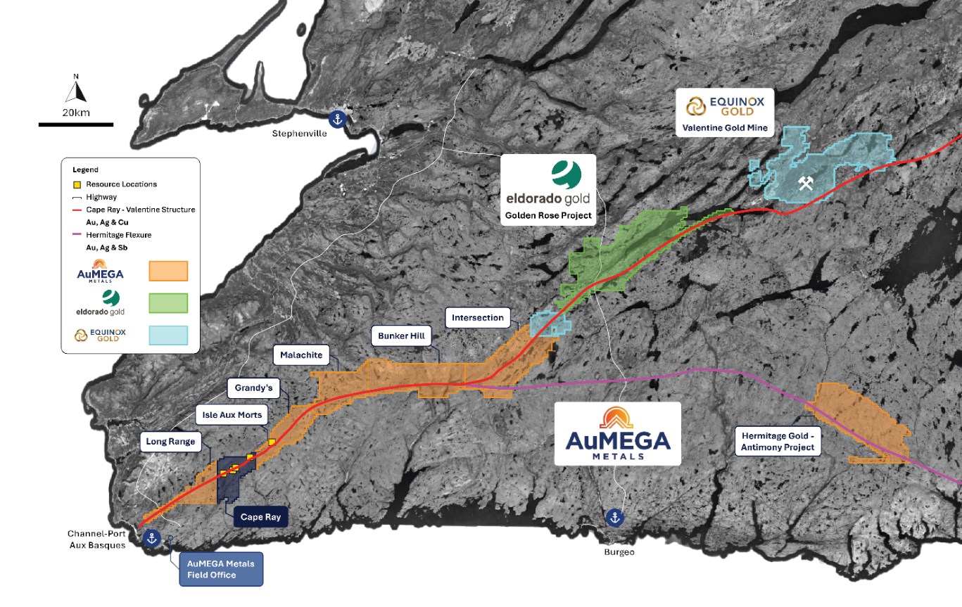
Figure 1: AuMEGA Metals portfolio on the Cape Ray Shear Zone and Hermitage Flexure.
To view an enhanced version of this graphic, please visit:
https://images.newsfilecorp.com/files/10713/270628_e72c9bc81427989c_002full.jpg
Overview
The Cape Ray Project hosts 420,000 ounces of gold in Indicated Resources and 141,000 ounces in Inferred Resources, estimated at a gold price of US
In recent months, AuMEGA completed an extensive review of both historical and new exploration data across all project areas, with a focus on Cape Ray. Much of the historical geological information had been limited to the resource pit shells.
This work integrated decades of legacy data with new high-resolution airborne electromagnetic ("EM"), magnetic and geochemical datasets2 acquired in 2025, aiming to fast-track discoveries through a modern, data-driven exploration approach3.
The review confirmed that systematic till geochemistry is a powerful tool for mapping gold trends along the CRSZ. Importantly, historic till anomalies closely mirror the known resource footprints, validating the method as an effective discovery tool for orogenic gold systems in glaciated terrains.
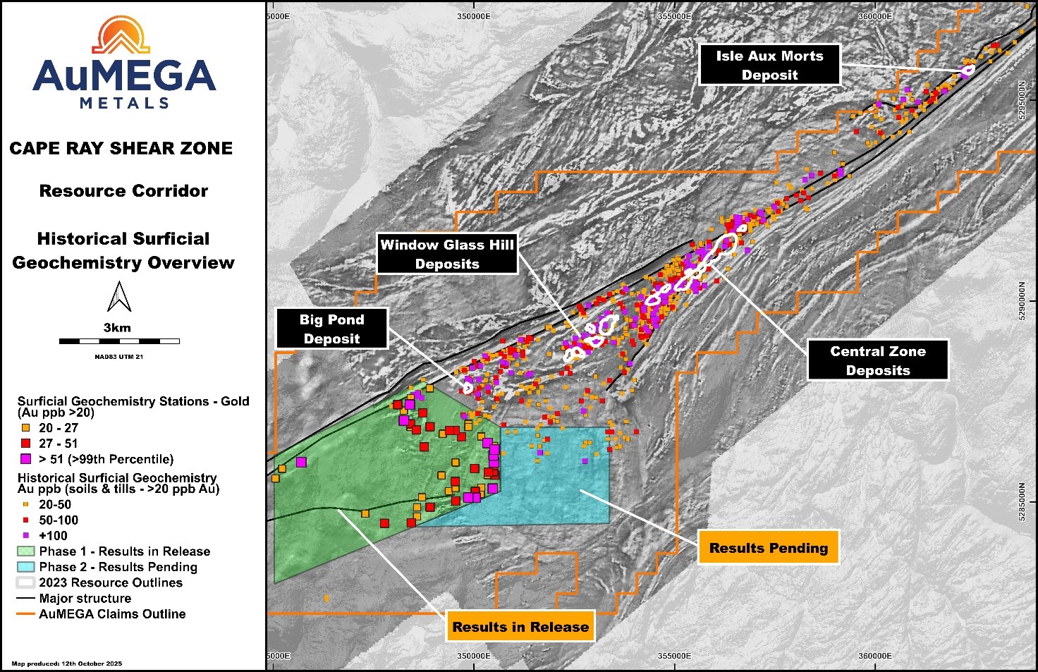
Figure 2: Cape Ray West results (>20ppb Au) in relation to the Historic surficial geochemical footprint (>20ppb Au) and pit shell outlines over the Cape Ray Resource Corridor.
To view an enhanced version of this graphic, please visit:
https://images.newsfilecorp.com/files/10713/270628_e72c9bc81427989c_003full.jpg
Cape Ray West Results
Building on this proven methodology, AuMEGA has completed an extensive till geochemical sampling and mapping program at Cape Ray West, aimed at expanding exploration into previously untested ground west of the current resource corridor (Figures 2 - 6).
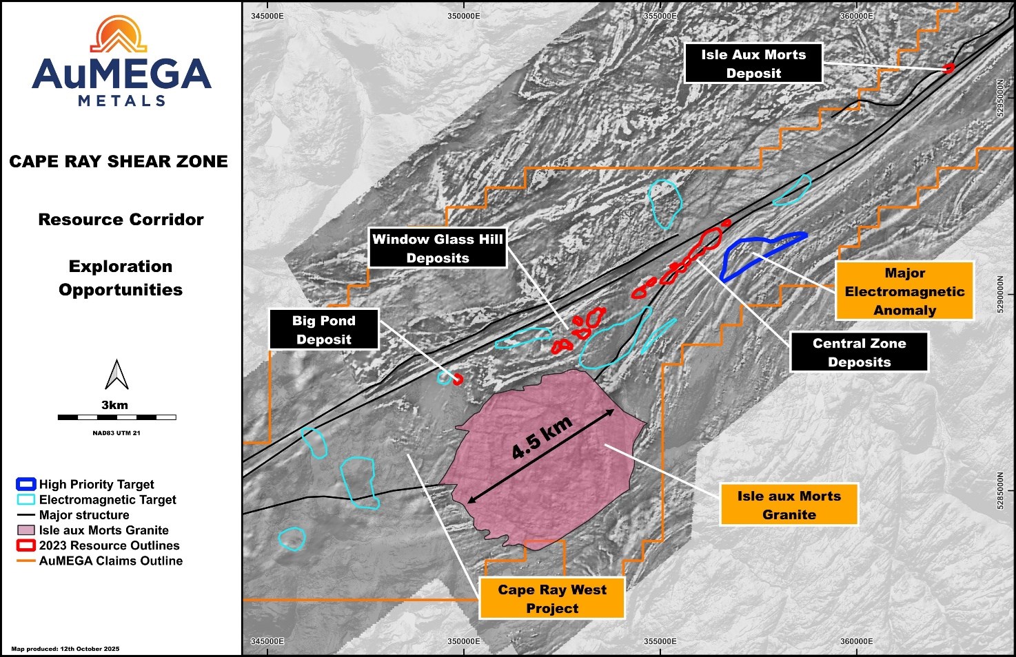
Figure 3: Cape Ray Project area.
To view an enhanced version of this graphic, please visit:
https://images.newsfilecorp.com/files/10713/270628_e72c9bc81427989c_004full.jpg
The Isle aux Morts Granite, a large felsic intrusive covering much of western Cape Ray, represents a major, untested discovery opportunity (Figure 3). Despite its size and proximity to known mineralised trends, neither the intrusive nor its contact zones have ever been drill tested.
To build on this potential, AuMEGA completed detailed geological mapping and rock sampling, integrating results with airborne magnetic and EM datasets to refine high-ranking structural and geochemical targets.
The till geochemical sampling grid was completed at 160 by 80 metre spacing, oriented north-south, with results defining three discrete gold-in-till anomalies (Figures 4 - 6 and Appendix 1 - Section 2: Balanced Reporting)4.
- Anomaly One
Trends northwest-southeast and is coincident with a geophysical feature of the same orientation. The anomaly extends into the Isle aux Morts Granite and along the northern boundary of a fault between paragneiss and siliciclastic sediments with a peak of 402 ppb gold and coincident arsenic anomalism.
- Anomaly Two
Occurs within the Isle aux Morts Granite, extending approximately 1,500 metres in length along a north-south trend coincident with geophysical features and mapped structures and quartz veins of the same orientation with a strong and coherent anomaly peaking at 118 ppb gold.
- Anomaly Three
Approximately 1,900 metres long, trending east-northeast to west-southwest, coincident with geophysical features within both the paragneiss and the Isle aux Morts Granite and a peak value of 113 ppb gold.
Collectively, these results underscore the untapped potential of the Isle aux Morts Granite as a new exploration front for AuMEGA and reinforce the Company's strategy of combining modern datasets with legacy knowledge to unlock new discoveries across the CRSZ.
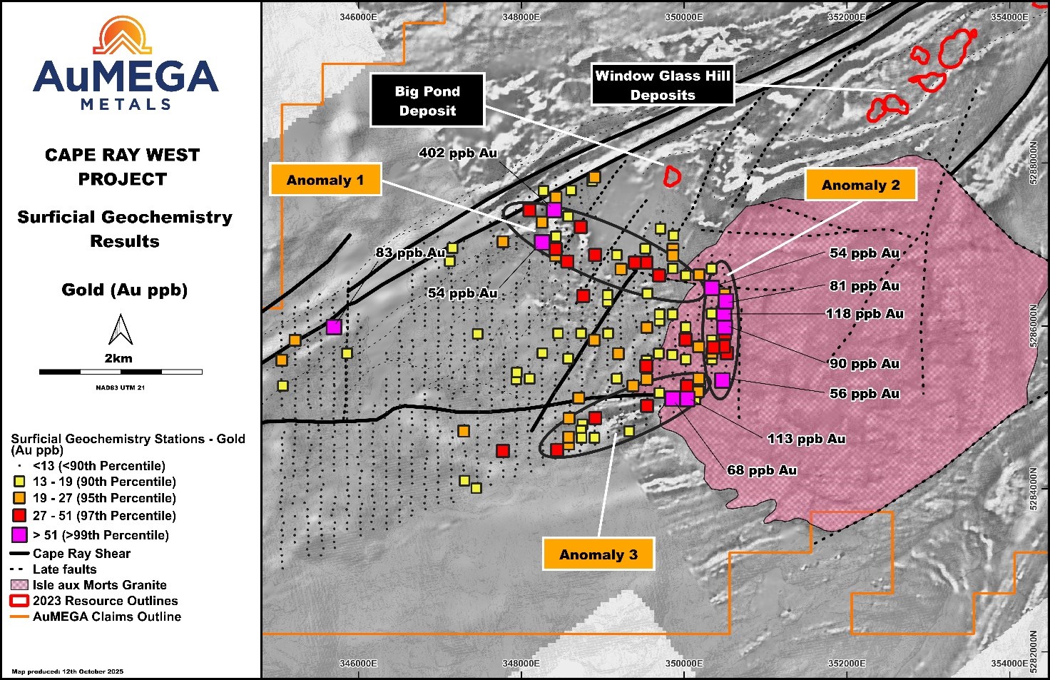
Figure 4: Gold-in-till results from Cape Ray West Project.
To view an enhanced version of this graphic, please visit:
https://images.newsfilecorp.com/files/10713/270628_e72c9bc81427989c_005full.jpg
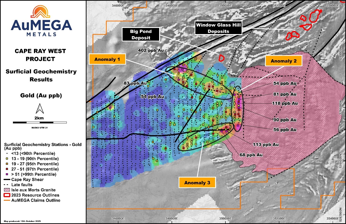
Figure 5: Gold-in-till results from Cape Ray West Project.
To view an enhanced version of this graphic, please visit:
https://images.newsfilecorp.com/files/10713/270628_e72c9bc81427989c_006full.jpg
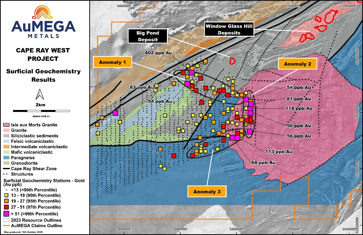
Figure 6: Gold-in-till results from Cape Ray West Project overlayed on a new geological map.
To view an enhanced version of this graphic, please visit:
https://images.newsfilecorp.com/files/10713/270628_e72c9bc81427989c_007full.jpg
Ongoing and Next Steps
Following receipt of preliminary results, the Company mobilized a field team to undertake a broader till survey and expand geological mapping and rock sampling over the majority of the Isle aux Morts Granite (Figure 2). Sampling has now been completed, and the material is being collated for dispatch to the laboratories for preparation and assaying.
While awaiting assay results, the Company is integrating new till assay and geological data with EM and magnetics geophysical datasets to finalise priority drill targets. The Company remains fully funded to commence drill testing at Cape Ray West in the fourth quarter of 2025.
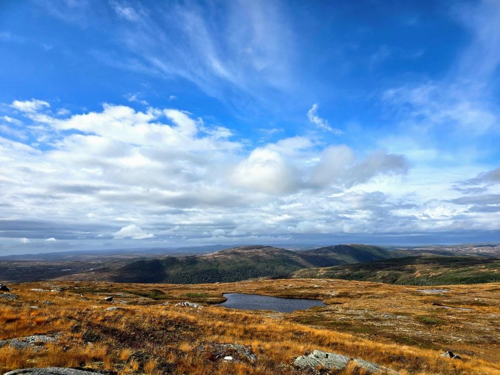
Figure 7: Isle aux Morts Granite looking north.
To view an enhanced version of this graphic, please visit:
https://images.newsfilecorp.com/files/10713/270628_e72c9bc81427989c_008full.jpg
< END >
This announcement has been authorised for release by the Company's Board of Directors.
To learn more about the Company, please visit www.aumegametals.com, or contact:
Sam Pazuki, Managing Director & CEO
Canada Phone: +1 780 665 4925
Australia Phone: +61 8 6117 0478
Email: info@aumegametals.com
About the Company
AuMEGA Metals Ltd (ASX: AAM) (TSXV: AUM) (OTCQB: AUMMF) is utilising best-in-class exploration to explore on its district scale land package that spans 110 kilometers along the Cape Ray Shear Zone, a significant under-explored geological feature recognised as Newfoundland, Canada's largest identified gold structure. This zone currently hosts Equinox Gold's Valentine Gold Project, a multi-million-ounce deposit which is the region's largest gold project, along with AuMEGA's expanding Mineral Resource.
The Company is supported by a diverse shareholder registry of prominent global institutional investors, and strategic investment from B2Gold Corp, a significant, intermediate gold producer.
Additionally, AuMEGA holds a 27-kilometre stretch of the highly prospective Hermitage Flexure and has also secured an Option Agreement for the Blue Cove Copper Project in southeastern Newfoundland, which exhibits strong potential for copper and other base metals.
AuMEGA's Cape Ray Shear Zone hosts several dozen high potential targets along with its existing defined gold Mineral Resource of 6.1 million tonnes grading an average of 2.25 g/t, totaling 450,000 ounces of Indicated Resources, and 3.4 million tonnes grading an average of 1.44 g/t, totaling 160,000 ounces in Inferred Resources5.
AuMEGA acknowledges the financial support of the Junior Exploration Assistance Program, Department of Industry, Energy and Technology, Provincial Government of Newfoundland and Labrador, Canada.
Reference to Previous Announcements
In relation to this news release, all data used to assess targets have been previously disclosed by the Company and referenced in previous JORC Table 1 releases. Please see announcements dated: 30th May 2023, 2nd October 2025, 11th August 2021 and 29th July 2025. In relation to the Mineral Resource estimate announced on 30th May 2023, the Company confirms that all material assumptions and technical parameters underpinning the estimates in that announcement continue to apply and have not materially changed. The Company confirms that the form and context in which the Competent Person's findings are presented have not been materially modified from the original market announcement.
Competent Person's Statements
Till Sampling
All till samples are collected using a hand auger to collect roughly 2 kg of material, the 'C-Horizon' is targeted but the 'B-Horizon' is collected where this is not possible. Notes are taken on the sample horizon as well as the sand vs silt fractions and moisture content. Samples are then sealed in pre-marked calico bags. Till samples are organized at the Company's facilities in Channel Port-aux-Basques, NL., before they are driven by company personnel to Eastern Analytical's facilities in Springdale, NL., for drying at 60°C and sieving to -63 μm. The dried and sieved fraction is then shipped to ALS Global ("ALS") facilities in Vancouver, BC where they undergo ICP-MS for 53 elements after an aqua regia digestion. All QA/QC data is reviewed by the Database Manager, Exploration Manager and/or Competent Person to ensure quality of assays. Batches containing multiple CRMs that report outside of two standard deviations from expected values are re-assayed. Both Eastern Analytical and ALS are ISO certified and are independent from the company.
Historic Data
Some data disclosed in this news release is related to historical sampling. The company has not independently analyzed the results in order to verify the results; however, the Company considers these historical results relevant as the Company is using this data as a guide to plan exploration programs.
Qualified Person
The scientific and technical information in this press release was reviewed and approved by Shamus Duff, P. Geo., Project Geologist. Mr. Duff is a Qualified Person as defined under National Instrument 43-101 and a Professional Geologist registered with Professional Engineers and Geoscientists of Newfoundland and Labrador (PEGNL). Mr. Duff consents to the publication of this press release and certifies that the information is provided fairly and accurately represents the scientific and technical information disclosed within it.
1 News release 30th May 2023
2 News release 2nd October 2025 & 11th August 2021
3 News release 29th July 2025
4 Appendix 1 can be seen on the ASX version of this press release. This can be found on the Company's website under Press Releases.
5 News release dated 30 May 2023
![]()
To view the source version of this press release, please visit https://www.newsfilecorp.com/release/270628