STOCK TITAN

Gladiator Intersects 24.0m @ 2.37% Cu Including 13.1m @ 3.89% Cu from 8m at Cowley, Extending High-Grade Copper Mineralization to Surface

The Cowley work is part of a 2026–27 exploration plan with a planned, fully funded budget of greater than $40 million.

(Moderate)
(Positive)
Tags

Gladiator Metals (GDTRF) reported a 24.0-metre copper intersection at Cowley and began drilling its Southern Limb.

On the Northern Limb, hole CPG-170 returned 24.0 metres grading 2.37% copper from 8.0 metres, including 13.1 metres at 3.89% copper. CPG-159 returned 36.3 metres at 1.03% copper, 0.25 grams per tonne gold and 860 parts per million molybdenum. CPG-171 returned 75.61 metres at 0.81% copper. Drilling across approximately 200 metres of east-west strike has defined Northern Limb mineralization to a vertical depth of 156 metres.

The first Southern Limb hole with assay results, CPG-173, returned 62.0 metres at 1.34% copper from 48.6 metres, including 32.6 metres at 1.70% copper. Gladiator expanded the Cowley drilling program from 8,000 metres to more than 16,000 metres and added a second rig. It has completed four Southern Limb holes; assay results have been received for the first.

Loading...
Loading translation...

AI-generated analysis. How Rhea-AI works. Not financial advice.

See more from StockTitan in Google Search and AI answers. Adds StockTitan as a preferred source · opens Google
Add on Google

Vancouver, British Columbia--(Newsfile Corp. - September 28, 2026) - Gladiator Metals Corp. (TSXV: GLAD) (OTCQX: GDTRF) (FSE: ZX7) (NSX: GM1) (ARBN: 693 952 895) ("Gladiator" or the "Company") has commenced drilling on the Southern Limb at Cowley, opening the next significant growth area while continued standout results extend broad zones of high-grade, near-surface copper mineralization on the Northern Limb, enhanced by material molybdenum, gold and silver credits. The latest results reinforce Cowley as a rapidly developing, near-surface resource-growth opportunity within the Whitehorse Copper Project.

HIGHLIGHTS: 

1. Results from near-surface drilling continue to expand Cowley’s scale and unlock significant resource-growth potential, extending significant high-grade shallow mineralization to the northeast and up dip to surface. 

2. Drilling results extending the Northern Limb to the northeast include: 

    • CPG-170:24.0 m @ 2.37% Cu from 8.0 m, incl.

      • 13.1 m @ 3.89% Cu.

    • CPG-159:36.3 m @ 1.03% Cu, 0.25 g/t Au and 860 ppm Mo from 39.8m, incl.

      • 28.1 m @ 1.25% Cu, 0.30 g/t Au and 1,013 ppm Mo from 48m.

    • CPG-171:75.61 m @ 0.81% Cu from 56.39m, incl.

      • 34.11m @ 1.22% Cu, 0.10 g/t Au, 6.20 g/t Ag & 405 ppm Mo from 56.39m

3. First systematic modern drilling of Southern Limb now underway opening the next major potential growth front, with a second rig added to accelerate resource delineation at Cowley. Results from the first hole completed on the Southern Limb returned: 

    • CPG-173:62.0 m @ 1.34% Cu, 0.10 g/t Au, 8.99 g/t Ag & 512 ppm Mo from 48.6 m, Incl.:

      • 9.0m @ 2.14 % Cu, 0.16 g/t Au, & 10.86 g/t Ag from 52 m, And

      • 32.6m @ 1.70 % Cu, 0.13 g/t Au, 11.96 g/t Ag & 815 ppm Mo from 78 m

4. Program doubled at Cowley from 8,000 m to more than 16,000 m following further mineralised-zone extensions and stronger than expected results across the Northern Limb.

Gladiator CEO Jason Bontempo commented:

"Cowley is delivering results that are driving a significant resource-growth story: broad, high-grade, near-surface copper mineralization with an increasingly important molybdenum credit.

"The consistency of results across the Northern Limb, combined with further zones of high-grade mineralization extending to surface and along strike to the northeast, continues to strengthen our confidence in Cowley's expanding scale and quality.

"With multiple holes returning more than 1,000 ppm Mo; molybdenum is emerging as a material by-product value driver that will significantly enhance Cowley's future metal mix.

"Commencing drilling on the Southern Limb marks a major step forward, with the first hole intersecting broad zones of high-grade mineralization in areas previously untested or not drilled by Gladiator at Cowley. With improved Class 3 access, Gladiator has the ability to systematically infill, extend and upgrade the broader Cowley system.

"We have expanded the Cowley program from an initial 8,000 metres to more than 16,000 metres in response to continued extensions of the mineralized zone and stronger-than-expected results throughout the Cowley area. A second rig has been added to accelerate drilling across what is becoming one of Gladiator's most important near-term value drivers."

SUMMARY

Cowley continues to expand in multiple directions, with broad, high-grade, near-surface drilling continuing to expand Cowley's Cu-Au-Ag-Mo mineralization and strengthening continuity, extending the system to surface and unlocking significant resource-growth potential to add tons and enhance future potential resource value.

Recent drilling across approximately 200 m of east-west strike on the Northern Limb has defined broad, high-grade Cu-Au-Ag-Mo mineralization to a vertical depth of 156 m below surface. Results from the northeastern section of the Northern Limb have exceeded expectations, prompting Gladiator to double the Cowley program from 8,000 metres to more than 16,000 metres. This combined with recently gained access to the area under Class 3 permit conditions, enables Gladiator to expand drilling into previously inaccessible areas and systematically test the broader Cowley mineralized system.

Overall, these results support a larger, higher-confidence Cowley system by increasing potential tonnage, strengthening local grade, improving Cu-Au-Ag-Mo continuity and reducing geological uncertainty across key parts of the prospect.

New Northern Limb intersections, include:

HoleTypeFrom-To (m)Interval
(m)
Cu %Au g/tAg g/tMo ppmHighlight
CPG-170
8.00-32.0024.002.370.077.7912524.0 m high-grade copper with silver

Incl.12.30-25.4013.103.890.1312.4514613.1 m very high-grade copper with silver
CPG-159
39.80-76.1036.301.030.256.8286036.3 m high-grade copper with gold, silver and molybdenum

Incl.48.00-76.1028.101.250.308.231,01328.1 m high-grade copper-gold-silver-molybdenum
CPG-171
56.39-132.0075.610.810.063.9741775.6 m broad strong copper mineralization

Incl.56.39-90.5034.111.220.106.2040534.1 m high-grade copper with silver
CPG-156
57.00-81.0024.000.690.095.761,64924.0 m copper-silver with strong molybdenum

Incl.59.00-71.0012.001.060.159.202,20712.0 m high-grade copper-silver-molybdenum

And75.00-79.004.000.640.074.752,8554.0 m strong copper with very high molybdenum
CPG-162
75.00-92.0017.000.900.074.0620217.0 m high-grade copper mineralization

Incl.82.00-90.108.101.640.127.042358.1 m high-grade copper with silver


The latest Cowley results deliver a major step forward in expanding the scale, continuity and near-surface potential of the Cu-Au-Ag-Mo system. Standout holes CPG-159, CPG-170, CPG-171 and CPG-156 confirm broad, high-grade mineralization across multiple areas: CPG-170 returned 24.00 m at 2.37% Cu from just 8.00 m, including 13.10 m at 3.89% Cu, while CPG-159 delivered 36.30 m at 1.03% Cu, 0.25 g/t Au, 6.82 g/t Ag and 860 ppm Mo. Together, these results extend high-grade mineralization laterally, vertically and to surface, reinforcing Cowley as a substantial, multi-metal potential resource-growth opportunity.

Importantly, the drilling is expanding Cowley in several directions at once. CPG-171 demonstrates strong vertical persistence with 75.61 m at 0.81% Cu, including 34.11 m at 1.22% Cu, while CPG-156 strengthens the western side of the eastern high-grade corridor with 24.00 m at 0.69% Cu and 1,649 ppm Mo, including 12.00 m at 1.06% Cu and 2,207 ppm Mo. Supporting holes CPG-157, CPG-160 and CPG-162 further tighten geological continuity and extend mineralization through the northeastern, southeastern and eastern margins. Collectively, the results point to a larger, more connected and higher-confidence mineralised system with clear potential to add tonnes, improve grade distribution and enhance the value of near-surface resource potential.

Southern Limb Drilling

Gladiator has commenced drilling on the Southern Limb at Cowley, opening a significant new resource-growth front in an area that remains materially less defined than the Northern Limb. The first hole completed at Southern Limb (CPG-173), returned:

  • 9.6m @ 0.86% Cu, 0.03 g/t Au, 8.52 g/t Ag & 19 ppm Mo from 2.4m,

  • 62.0 m @ 1.34% Cu, 0.10 g/t Au, 8.99 g/t Ag & 512 ppm Mo from 48.6 m, Incl.:

    • 47.30 m @ 1.48% Cu, 0.13 g/t Au, 11.14 g/t Ag and 655 ppm Mo from 52 m, Incl.:

    • 9.0m @ 2.14 % Cu, 0.16 g/t Au, 10.86 g/t Ag & 65 ppm Mo from 52 m, Plus

    • 32.6m @ 1.70 % Cu, 0.13 g/t Au, 11.96 g/t Ag & 815 ppm Mo from 78 m.

CPG-173 was continued down-dip past the Southern Limb and intersected the Northern Limb at depth, returning:

  • 26.2m @ 0.58% Cu, 0.06 g/t Au, 4.02 g/t Ag & 317 ppm Mo from 176.80 m

Gladiator has now completed 4 holes for 1,230 metres on the Southern Limb, with assays returned for the first completed hole (CPG-173).

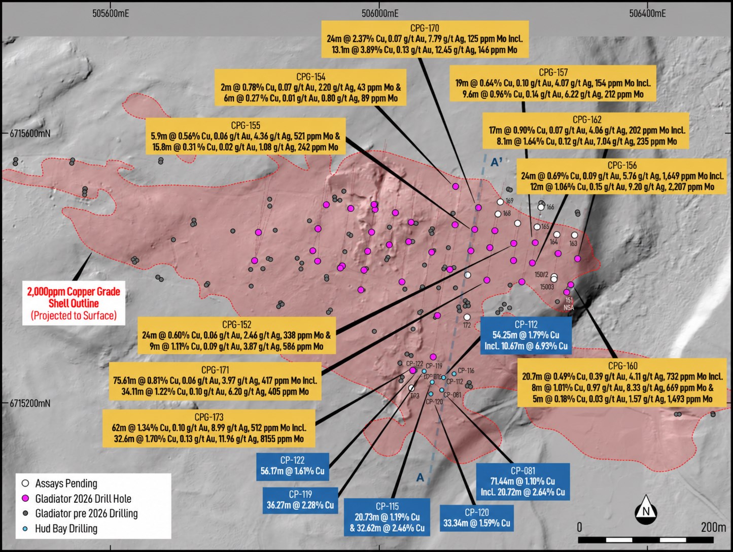
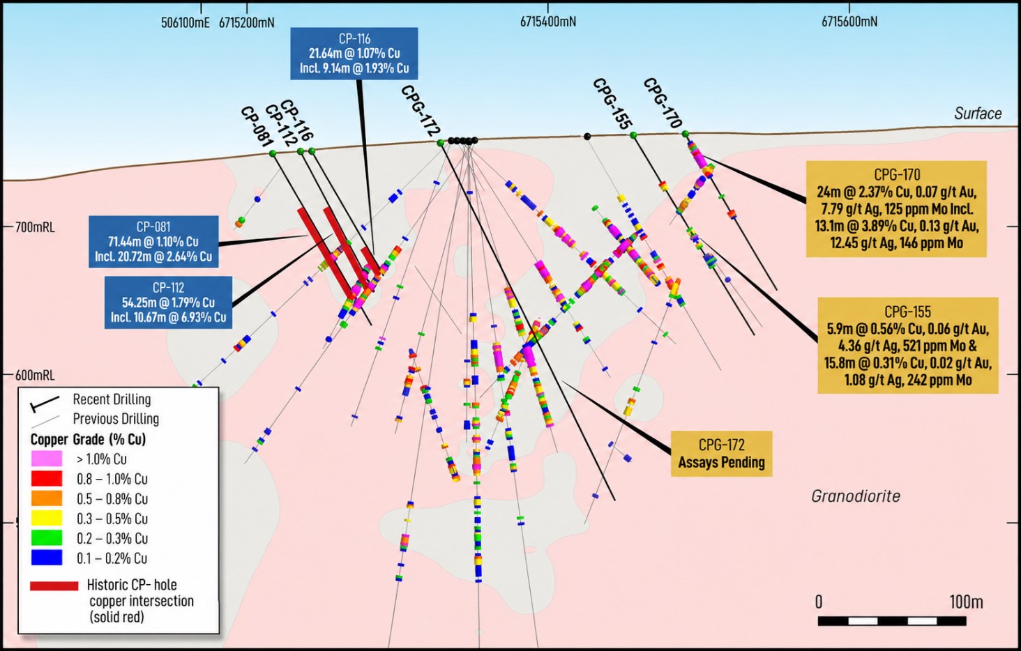
CPG-173 is located beside a cluster of historical drilling by a prior operator ("CP-" prefixed drillholes1 completed by Hudbay Minerals Inc.) in the 1980s that returned significant copper mineralization over more than 100 metres of strike (Figure 1 & Figure 2) that are the basis for immediate systematic drilling planned by the Company. These historical results include.

  • CP-115: 20.73 m @ 1.19% Cu from 47.85 m;

    • Plus 32.62 m @ 2.46% Cu from 80.77 m,

  • CP-112: 54.25 m @ 1.79% Cu from 41.76 m,

    • Incl.10.67 m @ 6.93% Cu from 85.34 m.

  • CP-122: 56.17 m @ 1.61% Cu from 56.91 m,

  • CP-119: 36.27 m @ 2.28% Cu from 72.24 m.

  • CP-081: 71.44 m @ 1.10% Cu from 41.64 m,

    • And 20.72 m @ 2.64% Cu from 81.69 m.

  • CP-120: 33.34 m @ 1.59% Cu from 72.12 m,

Improved Class 3 access is particularly significant, with its impact expected to be more meaningful than on the better-defined Northern Limb. Access under Class 3 conditions enables Gladiator an immediate Cowley catalyst, via systematic infill, to extend and test high-grade Southern Limb mineralization from surface and beneath shallow cover. This provides a clearer pathway to accelerating the conversion of compelling historical results and exploration potential upside into future resource growth.

1 Refer to Gladiator news releases dated April 3, April 27 and May 15, 2022 for the original disclosure of the historical drill results relating to holes prefixed "CP-". These historical results are re-reported in this release for context only, were not prepared in accordance with NI 43-101 or the JORC Code and should not be treated as NI 43-101- or JORC-compliant exploration results. Gladiator has not undertaken any independent investigation, nor has it independently analyzed the results of the historical exploration work in order to verify the results. The Company believes that the historical drill results currently do not conform to presently accepted industry standards. Gladiator considers these historical drill results relevant as the Company uses this data as a guide to plan future exploration and drilling programs. The Company also considers the data to be reliable for these purposes, however, the Company's future exploration work will include verification of the data through drilling.

COWLEY RESOURCE DELINEATION DRILLING

Cowley drilling commenced on 20 April and has expanded from an initial 8,000-metre programme to more than 16,000 metres following extensions of the mineralised zone and stronger-than-expected results across the northeastern Northern Limb. The expanded grid is designed to accelerate resource definition, test extensions and unlock Cowley's near-surface, high-grade potential.

The initial priority is to:

  • Complete step-out, sectional and infill drilling in areas where high-grade mineralization may be incorporated into future resource models; and

  • Assess near-surface high-grade mineralization for inclusion in future resource models on both the Southern and Northern limbs of the deposit. This work is intended to maximise shallow resource potential in areas where drilling directly above mineralisation has not previously been possible, including zones that outcrop at surface or lie beneath shallow cover of less than 10 metres.

  • Since the resumption of drilling, Gladiator has completed 51 holes for 7,657 metres, with assay results now received for holes CPG-154 to CPG-157, CPG-159 to CPG-162, CPG-170, CPG-171 and CPG-173 contained in this release.

Cannot view this image? Visit: https://images.newsfilecorp.com/files/1930/316218_076dd041a464d946_002.jpg

Figure 1: Plan map of Cowley over LiDAR hillshade. Drillholes reported in this release are highlighted in yellow, and Northern Limb holes with assays pending are shown with white collars. The section line indicates the location of Figure 2. Historical Hudbay intersections are shown in blue; refer to Gladiator news releases dated April 3, April 27 and May 15, 2022.

To view an enhanced version of this graphic, please visit:
https://images.newsfilecorp.com/files/1930/316218_076dd041a464d946_002full.jpg

Cannot view this image? Visit: https://images.newsfilecorp.com/files/1930/316218_076dd041a464d946_003.jpg

Figure 2: Section A-A1 through Cowley, viewed west, showing Gladiator drilling. New drill results reported in this release are highlighted in dark yellow, and historical Hudbay Minerals Inc. drilling is shown in blue. Refer to Figure 1 for the section location.

To view an enhanced version of this graphic, please visit:
https://images.newsfilecorp.com/files/1930/316218_076dd041a464d946_003full.jpg

EXPLORATION STRATEGY - 2026-27

These results form part of Gladiator's fully funded and fully permitted 2026 drill programme, which remains focused on accelerating resource definition at Cowley and rapidly expanding the high-grade Cub East discovery.

With a planned fully funded exploration budget of greater than $40 million and > 100,000 meters of drilling planned for 2026 & 2027, Gladiator is poised to complete a very exciting and positive year focused on the drill bit.

Plans are also underway to extend the geophysical "road map" across the broader belt and build on the successful 2025 geophysical targeting workflow of gravity surveying followed by induced polarization. Gladiator has doubled its geophysical budget following the new discovery at Cub East in 2025, where recent drilling, utilizing this geophysical targeting has returned (refer to Company news release dated May 21 & June 04, 2026):

  • BCG-020: 40m @ 2.01% Cu + 0.72g/t Au + 19.43g/t Ag from 176m

    • Incl. 24m @ 3.03% Cu+ 1.08g/t Au + 28.91g/t Ag from 190m

  • BCG-023: 35.9m @ 2.68% Cu, 1.35 g/t Au & 19.55g/t Ag from 172.1m

    • Incl. 22m @ 4.24% Cu, 2.16 g/t Au, & 31.04g/t Ag from 172.1m

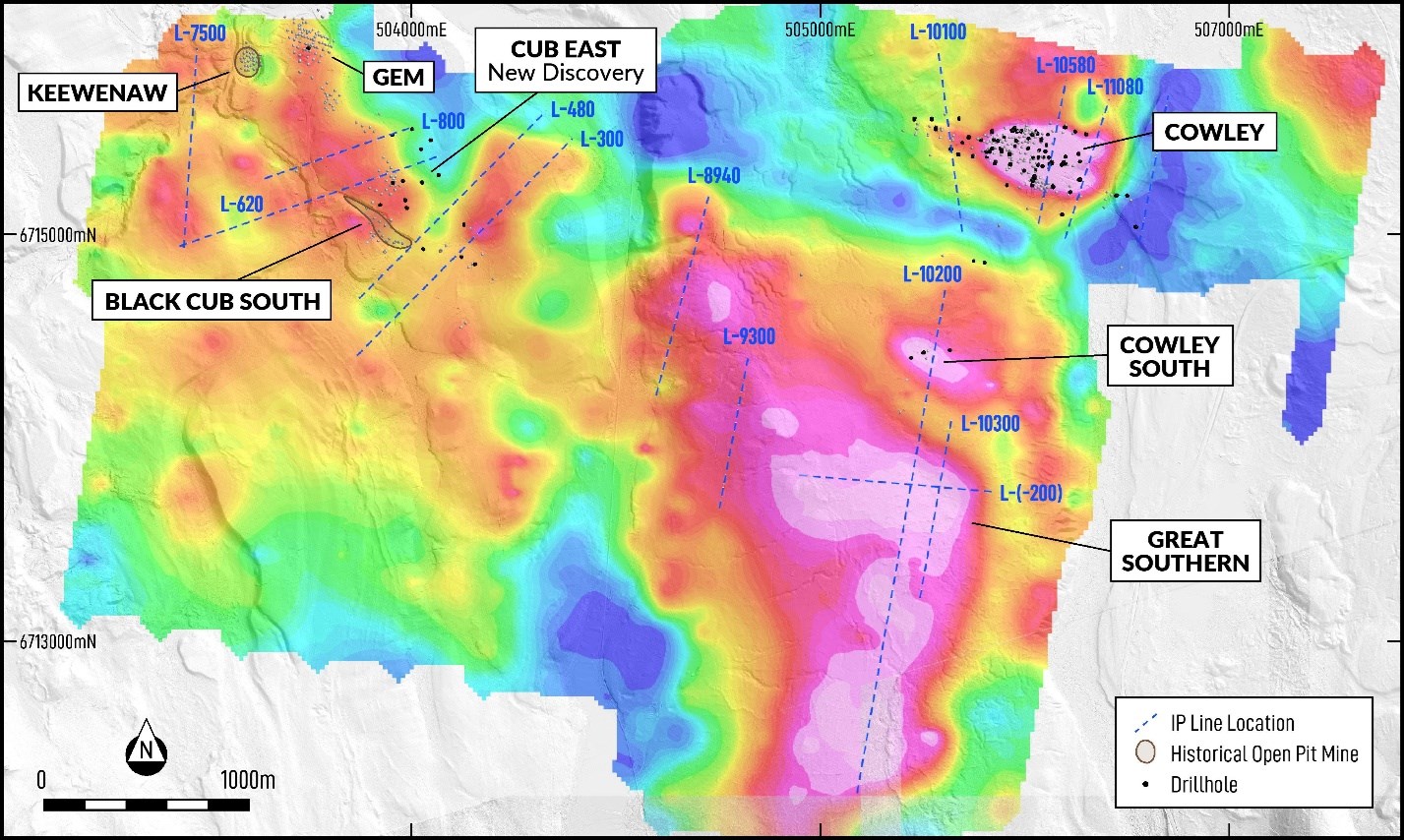
Combined with the generation of the Great Southern Target south of Cowley (Figure 3), this ensures that Gladiator maintains a pipeline of high-quality resource opportunities into the future.

Cannot view this image? Visit: https://images.newsfilecorp.com/files/1930/316218_076dd041a464d946_004.jpg

Figure 3: Plan map of Black Cub to Cowley over ground gravity, showing completed IP Lines.

To view an enhanced version of this graphic, please visit:
https://images.newsfilecorp.com/files/1930/316218_076dd041a464d946_004full.jpg

Hole IdDepthEastNorthRLDipAzimNoteFromToInterval
(m)
Cu
(%)
Au
(g/t)
Ag
(g/t)
Mo
(ppm)
Remarks
CPG-152150.88506,2026,715,438759-588
43.0067.0024.000.600.062.46338Includes 1.1 m of Lost Core


Incl.52.0061.009.001.110.093.87586Includes 0.5 m of Lost Core
CPG-153196.60506,2146,715,380756-684
57.20130.0072.800.620.074.441,018Previously Released


Incl.89.00118.5029.500.990.097.411,302


Incl.93.00116.4023.401.160.118.811,226
CPG-15485.34506,1156,715,522
-4912
16.0018.002.000.780.072.2043


61.0067.006.000.270.010.8089
CPG-155156.97506,1436,715,457
-608
37.1043.005.900.560.064.36521


73.0088.8015.800.310.021.08242


98.00104.006.000.210.010.2037
CPG-156147.83506,2306,715,407
-5612
57.0081.0024.000.690.095.761,649


Incl.59.0071.0012.001.060.159.202,207


And75.0079.004.000.640.074.752,855
CPG-157150.27506,2346,715,438
-587
53.0072.0019.000.640.104.07154 Includes 0.4 m of Lost Core


56.4066.009.600.960.146.22212
CPG-158195.07506,2616,715,386755-6711
74.00123.0049.001.720.2711.44800 Previously Released


Incl.76.00116.0040.001.980.3113.29920
CPG-158D1170.69506,2616,715,386755-5814
62.5083.0020.500.870.117.95657 Previously Released


Incl.62.5064.502.003.950.0048.9017


And75.0083.008.001.060.237.031,188


89.90106.2016.300.830.175.39358
CPG-158D2181.36506,2626,715,381754-90190


Assays Pending
CPG-158D3301.75506,2616,715,381754-81172


Assays Pending
CPG-159150.88506,2686,715,424756-595
39.8076.1036.301.030.256.82860


Incl.48.0076.1028.101.250.308.231,013
CPG-160181.36506,2876,715,375751-5610
72.3093.0020.700.490.394.11732


Incl.76.0084.008.001.010.978.33669


And88.0093.005.000.180.031.571,493
CPG-161128.02506,2816,715,366751-8510


NSA
CPG-162150.88506,2976,715,415754-6010
75.0092.0017.000.900.074.06202


Incl.82.0090.108.101.640.127.04235
CPG-163166.12506,2936,715,450755-613


Assays Pending
CPG-164129.54506,2666,715,450757-585


Assays Pending
CPG-165140.21506,2376,715,462760-576


Assays Pending
CPG-16682.29506,2426,715,492761-577


Assays Pending
CPG-167140.20506,2086,715,467761-5914


Assays Pending
CPG-168140.21506,1786,715,481762-5914


Assays Pending
CPG-169112.79506,1826,715,499762-595


Assays Pending
CPG-170121.92506,1496,715,491762-606
8.0032.0024.002.370.077.79125


Incl.12.3025.4013.103.890.1312.45146


60.1064.003.900.760.033.60479
CPG-171228.60506,1626,715,382758-675
42.4046.734.330.290.052.8879


56.39132.0075.610.810.063.97417 Includes 0.6 m of Lost Core


Incl.56.3990.5034.111.220.106.20405
CPG-172300.23506,1316,715,327756-6414


Assays Pending
CPG-173373.38506,0546,715,248752-617
2.4012.009.600.860.038.5219


48.60110.6062.001.340.108.99512


Incl.52.0099.3047.301.480.1311.14655


Incl.52.0061.009.002.140.1610.8665


Plus78.00110.6032.601.700.1311.96815


176.80203.0026.200.580.064.02317 Northern Limb
CPG-174256.03506,0486,715,222753-6010


Assays Pending


Table 1: Recently returned drill assay results from Cowley drill holes. Note that the quoted intersections are reported as interval widths and not true widths. True widths of the intersected mineralised skarn system are complex, with different grade distributions present related to the form of the contact between the granodiorite and sedimentary units, as well as different vein generations and orientations within the various intervals.

Where core loss is noted in the remarks column, part of the reported interval returned no core. That portion is assigned no value when calculating the weighted average assay result. NSA refers to No Significant Assays Returned

Hole IdDepthEastNorthRLDipAzimNoteFromToInterval
(m)
Cu
(%)
Au
(g/t)
Ag
(g/t)
Mo
(ppm)
Remarks
CP-081132.89506,094 6,715,219749-6011
41.64113.0871.441.10


Incl.53.3459.446.101.17


And.81.69102.4120.722.64


CP-112106.68506,0976,715,238751-6311
41.7696.0154.251.79


Incl.85.3496.0110.676.93


CP-115121.92506,0806,715,231751-5911
47.8568.5820.731.19


Plus80.77113.3932.622.46


Incl.80.77103.9423.173.19


CP-11696.93506,1136,715,242751-6011
75.2996.9321.641.07


Incl.75.2984.439.141.93


CP-119112.47506,0686,715,246752-6011
72.24108.5136.272.28


CP-120114.30506,0776,715,213749-5811
72.12105.4633.341.59


Includes 5.2 Ft of Unsampled Core


Incl.82.60105.4622.862.05


No Samples 306.2-313.3, 330-340 Ft
CP-122117.96506,0546,715,249752-6011
56.91113.0856.171.61


Incl.58.5282.9124.391.88


And92.05109.1217.072.25


Table 2: Selective Historic Hudbay drilling results, Note holes were sampled only for copper by unknown method.

Where core loss is noted in the remarks column, part of the reported interval returned no core. That portion is assigned no value when calculating the weighted average assay result. NSA refers to No Significant Assays Returned

THE WHITEHORSE COPPER PROJECT

The Whitehorse Copper Project is an advanced-stage high-grade copper (Cu), molybdenum (Mo), silver (Ag) and gold (Au) skarn exploration project in the Yukon Territory, Canada.

Copper mineralization was first discovered in 1897 on the Whitehorse Copper Belt and comprises over 30 copper-related, primarily skarn occurrences covering an area of 35 km long by 5 km wide on the western margin of Whitehorse City, Yukon.

Exploration and mining development have been carried out intermittently since 1897, with the main production era lasting between 1967 and 1982, when production from primarily the Little Chief deposit totalled 267,500,000 pounds copper, 225,000 ounces of gold and 2,838,000 ounces of silver from 10.5 million tonnes of mineralized material milled (Watson, 1984). The Whitehorse Copper Project is accessible by numerous access roads and trails located within 2 km of the South Klondike Highway and the Alaska Highway. An extensive network of historical gravel exploration and haul roads exists throughout the project area, providing excellent access to the claim package. Access to existing electric power facilities is available through the main Yukon power grid.

PROJECT HIGHLIGHTS

  • Advanced 35 km long high-grade copper belt.
  • Located on western margin of infrastructure rich Whitehorse City, Yukon
  • Greater than 50,000 m of drilling planned for 2026, focused initially on near-term high-grade copper skarn resource prospects including the cornerstone Cowley Prospect, the recently discovered Cub East Prospect and the significant exploration potential surrounding the Cowley and Cub East mineralised systems.
  • Later in the year, focus will revert to the known mineralised areas adjacent to previous operating mines, including the Chiefs and Arctic Chief-Best Chance trends.
  • Targeting to report maiden high-grade copper NI 43-101 compliant inferred resource(s), in 2026 for Cowley on completion of Class 3 delineation drilling.
  • The Project area was a previous producer at Little Chief, Arctic Chief, Keewenaw & Black Cub South and other deposits.
  • Between 1967-82 Hudson Bay Mining & Smelting mined 10.5 mt at 1.5% Cu plus 0.75 g/t Au (Watson P.H. (1984) The Whitehorse Copper Belt - A Compilation. Yukon Geological Survey, Open File 1984-1).
  • Key Institutional Investors - BlackRock, Dynamic, Mackenzie, Macquarie Bank and Orimco.

QA / QC

Drilling completed by Gladiator is irregularly spaced to test parts of the mineralised systems. Holes are directionally surveyed utilising a north-seeking gyro direction tool. Drill collars are subsequently surveyed utilising a high-accuracy RTK DGPS or DeviSite system. Diamond drilling is usually cased, then cored utilising HTW diameter before reducing at shallow depth in stable ground to NTW diameter drill core.

Mineralized quoted intersections are reported as interval widths and not true width. True widths of the intersected mineralised skarn system are complex, making an estimate of the true width unreliable. This is due to different grade distributions and angle geometries present related to the form or outline of the contact between the granodiorite and sedimentary units as well as different vein paragenesis and orientations within the various intervals. Where possible, drilling is conducted perpendicular to interpreted mineralisation.

Upon drilling of diamond core, Gladiator undertakes geological logging, marking up of lineal length of the core, recording core recovery, and Geotech measurements such as RQDs and taking core photographs.

Based on the geological logging, core is then marked up for sampling with a new sampling ticket that matches the submitted sample for analysis at the start of the sample interval. The drill core is then cut in half utilising a core saw equipped with a diamond saw blade. The core samples are sent for analysis and the remaining half core is retained for future reference. Certified Reference Materials (CRMs) or known blank material is placed within the sampling sequence at a nominal sampling rate of at least 1 in 20 samples to monitor the laboratory.

Samples are submitted to the Whitehorse-based prep facility of ALS Global Laboratory (Canada). Samples subject to this release were crushed to 70% less than 2 mm before pulverising to better than 85% passing <75 microns. Assay pulps are then transported by ALS to the Vancouver (Langley) facility to be analysed. On occasions where the Whitehorse prep facility has reduced capacity to complete preparation of the samples in a timely manner, samples may be forwarded by ALS Global to its Langley facility for preparation utilising the same method as described above.

Samples were then analysed by ALS method ME-ICP61 (34 Element four-acid digestion with ICP-AES finish), with over-limits for Cu analysed by method CU-OG62 (four-acid digestion with ICP finish.). Au is analysed by ALS method AU-AA25 (Ore Grade Au 30 g Fire Assay AA Finish). As part of this process, Gladiator also captures the required sampling metadata to potentially utilise the core and analysis for any future requirements if deemed acceptable. The QA/QC meets the current required standards under reporting instruments, such as National Instrument 43-101. At this point, Gladiator regards the data collected from this exercise as reliable for the purposes of identifying future exploration targets and may use it to inform future drilling and exploration campaigns.

As part of this process, Gladiator captures the required sampling metadata to potentially utilise the core and analysis for any future requirements if deemed acceptable. Further drilling may be required to confirm the reliability or usability of this data in the future, including but not limited to twinning of reported mineralisation. This may be required where Gladiator is unable to confirm the accuracy of the stated drill collar location, re-enter the holes to confirm depths and undertake directional surveys, or confirm that the QA/QC meets the current required standards under reporting instruments such as National Instrument 43-101. At this point, the Company is treating the data collected from this exercise as reliable for the purposes of identifying future exploration targets and informing future drilling and exploration campaigns.

References:

Watson P.H. (1984) The Whitehorse Copper Belt - A Compilation. Yukon Geological Survey, Open File 1984-1.(https://data.geology.gov.yk.ca/Reference/42011#InfoTab)

Tenney D. (1981) - The Whitehorse Copper Belt: Mining, Exploration and Geology (1967-1980). (https://ia800602.us.archive.org/7/items/whitehorsecopper00tenn/whitehorsecopper00tenn.pdf)

Qualified Person

All scientific and technical information in this news release has been prepared or reviewed and approved by Kell Nielsen, the Company's Vice President Exploration, a "qualified person" as defined by NI 43-101.

Competent Persons Statement

The information in this report that relates to historical estimates and exploration results is an accurate representation of the available data and studies for the Project, is based on, and fairly represents, information either compiled or reviewed by Mr. Kell Nielsen who is a Fellow of the Australasian Institute of Mining and Metallurgy. Mr. Nielsen is the Company's Vice President Exploration. Mr .Nielsen has sufficient experience which is relevant to the style of mineralisation and type of deposit under consideration and to the activity which he is undertaking to qualify as a Competent Person (CP) as defined in the 2012 Edition of the Joint Ore Reserves Committee (JORC) "Australasian Code for Reporting of Exploration Results, Mineral Resources and Ore Reserves". Mr. Nielsen consents to the inclusion in the announcement of the matters based on his information in the form and context in which it appears.

Hudbay Drilling Disclaimer

The Hudbay CP-series intersections set out below are historical results that were previously disclosed and are re-reported in this release for geological context only. These historical results were not prepared in accordance with NI 43-101 or the JORC Code and should not be relied upon as NI 43-101- or JORC-compliant exploration results. Gladiator has not completed sufficient work to independently verify the historical drilling, sampling, analytical methods, quality assurance/quality control procedures or true widths, and the results should be considered indicative until validated by the Company's current drilling program.

Forward-Looking Statements

Neither the TSX Venture Exchange nor its Regulation Services Provider (as that term is defined in the policies of the TSX Venture Exchange) accepts responsibility for the adequacy or accuracy of this release.

This news release does not constitute an offer to sell or a solicitation of an offer to sell any of the securities in the United States. The securities have not been and will not be registered under the United States Securities Act of 1933, as amended (the "U.S. Securities Act") or any state securities laws and may not be offered or sold within the United States or to U.S. Persons unless registered under the U.S. Securities Act and applicable state securities laws or an exemption from such registration is available.

Certain of the statements and information in this news release constitute "forward-looking statements" or "forward-looking information". Any statements or information that express or involve discussions with respect to predictions, expectations, beliefs, plans, projections, objectives, assumptions or future events or performance (often, but not always, using words or phrases such as "expects", "anticipates", "believes", "plans", "estimates", "intends", "targets", "goals", "forecasts", "objectives", "potential" or variations thereof or stating that certain actions, events or results "may", "could", "would", "might" or "will" be taken, occur or be achieved, or the negative of these terms and similar expressions) that are not statements of historical fact may be forward-looking statements or information.

Forward-looking statements or information are subject to a variety of known and unknown risks, uncertainties and other factors that could cause actual events or results to differ from those reflected in the forward-looking statements or information, including, without limitation, the need for additional capital by the Company through financings, and the risk that such funds may not be raised; the speculative nature of exploration and the stages of the Company's properties; the effect of changes in commodity prices; regulatory risks that development of the Company's material properties will not be acceptable for social, environmental or other reasons; availability of equipment (including drills) and personnel to carry out work programs; and that each stage of work will be completed within expected time frames. This list is not exhaustive of the factors that may affect any of the Company's forward-looking statements or information. Although the Company has attempted to identify important factors that could cause actual results to differ materially, there may be other factors that cause results not to be as anticipated, estimated, described or intended. Accordingly, readers should not place undue reliance on forward-looking statements or information.

The Company's forward-looking statements and information are based on the assumptions, beliefs, expectations and opinions of management as of the date of this news release, and other than as required by applicable securities laws, the Company does not assume any obligation to update forward-looking statements and information if circumstances or management's assumptions, beliefs, expectations or opinions should change, or changes in any other events affecting such statements or information.

ON BEHALF OF THE BOARD

"Jason Bontempo"
Jason Bontempo
Director and CEO

For further information please contact:
info@gladiatormetals.com
+1 778 726 3356

This announcement has been authorized for release by the Board of Gladiator Metals Corp. (ARBN 693 952 895)

JORC Table 1.
The following Tables are provided for the reporting of Exploration Results in accordance with the JORC Code (2012).

Section 1: Sampling Techniques and Data
(Criteria in this section applies to all succeeding sections)

CriteriaJORC Code explanationCommentary
Sampling techniques
  • Nature and quality of sampling (e.g., cut channels, random chips, or specific specialised industry standard measurement tools appropriate to the minerals under investigation, such as downhole gamma sondes, handheld XRF instruments, etc.). These examples should not be taken as limiting the broad meaning of sampling.
  • Include reference to measures taken to ensure sample representivity and the appropriate calibration of any measurement tools or systems used.
  • Aspects of the determination of mineralisation that are Material to the Public Report.
  • In cases where 'industry standard' work has been done this would be relatively simple (e.g., 'reverse circulation drilling was used to obtain 1 m samples from which 3 kg was pulverised to produce a 30 g charge for fire assay'). In other cases, more explanation may be required, such as where there is coarse gold that has inherent sampling problems. Unusual commodities or mineralisation types (e.g., submarine nodules) may warrant disclosure of detailed information.
Gladiator Drilling 2023 to Present:
Hole Prefixes (ACG, BCG, LCG, VLG & CPG)
  • Diamond drilling completed by Gladiator has been conducted by Kluane Drilling Limited utilizing either N Thin Wall (NTW) or H Thin Wall (HTW) sized diamond core bits, a professional and industry known drilling contractor.
  • Upon drilling of diamond core, Gladiator undertakes geological logging, marking up of lineal length of the core, recording core recovery, and Geotech measurements such as RQD's and taking core photographs prior to the core being cut and sampled.
  • Based on the geological logging, core is then marked up for sampling with a new sampling ticket that matches the submitted sample for analysis at the start of the sample interval, the drill core is then cut in half utilizing a core saw equipped with a diamond saw blade. The core samples are then sent for analysis and the remaining half core retained for future reference.
  • Certified Reference Materials (CRMs) or known blank material is placed within the sampling sequence at a nominal sampling rate of at least 1 in 20 samples submitted to the laboratory as to monitor the Laboratory
  • Coarse duplicates are nominally placed in the sequence, where mineralization is expected to be returned
  • Samples are submitted to the Whitehorse based prep facility of ALS Global Laboratory (Canada). Samples subject to this release were crushed to 70% less than 2mm before pulverizing to better than 85% passing <75 microns. Assay pulps are then transported by ALS to the Vancouver (Langley) facility to be analysed. On occasions where the Whitehorse prep facility has reduced capacity to complete preparation of the samples within a timely manner, samples may be forwarded by ALS Global to their Langley facility for preparation utilising the same method as described above.
  • Samples were then analysed by ALS method ME-ICP61 (34 Element four-acid digestion with ICP-AES finish), with over limits for Cu analysed by method CU-OG62 (Aqua Regia with ICP-MS finish). Au is analysed by ALS method AU-AA25 (Ore Grade Au 30g Fire Assay AA Finish). As part of this process, Gladiator also captures the required sampling metadata to potentially utilize the core and analysis for any future requirements if deemed acceptable. The QA/QC meets the current required standards under reporting instruments, such as National Instrument 43-101 and is reported in accordance with the JORC Code (2012). At this point, Gladiator regards the data collected from this exercise as reliable for the purposes of identifying future exploration targets and may be used to inform future drilling and exploration campaigns
Gladiator Rock Chip Sampling (2023 to Present):
  • Rock Chip Sampling completed by Gladiator and subject to this release has been obtained from Outcrop, Sub-Crop and Float Material in the field. Sampling is completed by sampling a selective part of the material of approximately 0.5 kg or greater. The sample is geological logged and photographed in the field with its metadata being recorded.
  • QA/QC or the addition of CRM's and "Blanks" are inserted on an Ad-Hoc basis as the material will not be utilized in the calculation of resources or reserves, and rock chip assays are not reported as Exploration Results in this JORC Table.
  • Samples are submitted to ALS Global Laboratory (Canada) as above (Under Gladiator Drilling).
  • In the opinion of the Competent Person, rock chip results are used internally as a qualitative guide to mapping and target generation only and are not reported as Exploration Results in this JORC Table, nor used in the calculation of reported drill-hole intersections or in any Mineral Resource or Ore Reserve estimate.
Historic Data Prior to 2023 (Pre-Gladiator):
  • Drilling completed prior to Gladiator, is generally considered to be unreliable and has limited or unrecorded (metadata) regarding the sampling and assaying techniques employed or core size drilled. Core drilled historically (pre 2000) was commonly drilled as AQ, BQ or NQ sized core.
  • Gladiator, utilizes historic drilling as a guide and does not consider it to be effective or accurate for the purposes of resource estimation, but useful as a targeting data set to guide future exploration and or development. For the purpose of this release, these samples should be treated as historic in nature and do not conform to a mineral reporting code, where they have been included is to provide "material" support to this release.
Drilling techniques
  • Drill type (e.g., core, reverse circulation, open-hole hammer, rotary air blast, auger, Bangka, sonic etc.) and details (e.g., core diameter, triple or standard tube, depth of diamond tails, face-sampling bit or other type, whether core is orientated and if so, by what method, etc.).
Gladiator Drilling 2023 to Present:
  • Drilling Completed by Kluane Drilling
  • Core is drilled as orientated core utilising industry standard core orientation tools.
  • Core is often broken and fractured, meaning that core orientation is not effective (generally < 80% effective)
  • Drilling is completed utilizing either N Thin Wall (NTW) or H Thin Wall (HTW) sized diamond core bits
Historic Data Prior to 2023 (Pre-Gladiator):
  • Diamond drilling was undertaken over a period from 1957 to 2020, by various contractors
  • No structural measurements have been reported or observed from historic data, where core is available (Drilling campaigns from 2016 to 2020), core has been retrieved relogged, photographed and sampled under Gladiator Standard processes. No core orientations were observed from this process.
  • AQ, BQ or NQ core diameters were widely employed prior to 2016, with drilling completed post 2016 comprising NTW & HTW core sizes.
Drill sample recovery
  • Method of recording and assessing core and chip sample recoveries and results assessed.
  • Measures taken to maximise sample recovery and ensure representative nature of the samples.
  • Whether a relationship exists between sample recovery and grade and whether sample bias may have occurred due to preferential loss/gain of fine/coarse material.
Gladiator Drilling 2023 to Present:
  • Core Recoveries are generally very good with > 95% common, Gladiator completes systematic measurement and reporting of core recovery included in drillhole logging. Due to the consistent high recovery rates, no relationship has been determined between sample recovery and grade
Historic Data Prior to 2023 (Pre-Gladiator):
  • No systematic measurement and reporting of core recovery included in drillhole logging. Therefore, no relationship can be determined between sample recovery and grade
Logging
  • Whether core and chip samples have been geologically and geotechnically logged to a level of detail to support appropriate Mineral Resource estimation, mining studies and metallurgical studies.
  • Whether logging is qualitative or quantitative in nature. Core (or costean, channel, etc) photography.
  • The total length and percentage of the relevant intersections logged.
Gladiator Drilling 2023 to Present:
  • Gladiator undertakes geological logging, marking up of lineal length of the core, recording core recovery, and Geotech measurements such as RQD's and taking core photographs prior to the core being cut and sampled
  • Drilling completed by Gladiator is deemed sufficient to support resource estimation in accordance with the JORC Code (2012) or NI-43-101 standards.
Historic Data Prior to 2023 (Pre-Gladiator):
  • Data prior to 2023 is not sufficient to support resource estimation in accordance with the JORC Code (2012) or NI-43-101 standards and will not be used by Gladiator for these purposes.
Sub-sampling techniques and sample preparation
  • If core, whether cut or sawn and whether quarter, half or all core taken.
  • If non-core, whether riffled, tube sampled, rotary split, etc and whether sampled wet or dry.
  • For all sample types, the nature, quality and appropriateness of the sample preparation technique.
  • Quality control procedures adopted for all sub-sampling stages to maximise representivity of samples.
  • Measures taken to ensure that the sampling is representative of the in situ material collected, including for instance results for field duplicate/second-half sampling.
  • Whether sample sizes are appropriate to the grain size of the material being sampled.
Gladiator Drilling 2023 to Present:
  • Diamond drilling completed by Gladiator is cut in half utilising a diamond core saw. Samples are collected over the marked up interval that has been outlined by the logging geologist. Samples are collected generally on an interval length of 1.5 to 2.5m for NTW sized core or 0.5 to 1.5m for HTW sized core.
  • Once cut samples are placed in separate bags within a palletized box and the lid securely attached.
  • Samples are directly delivered to ALS Whitehorse for processing by Gladiator.
  • Sampling is considered to be of industry standard, appropriate and representative
  • Gladiator instructs the lab to prepare 1-3 duplicates per drill hole of the interval for analysis after crushing (coarse duplicates), no concerns have been noted to date from the coarse duplicates
  • Gladiator has completed limited sub sampling of the original interval by obtaining quarter core from the original interval and resubmitting the interval for analysis, no concerns have been noted to date from the quarter core duplicates.
Historic Data Prior to 2023 (Pre-Gladiator):
  • No systematic reporting of the sampling techniques or preparation has been noted, as Gladiator considers this data to be a guide to future exploration, no further work is planned to categorize the sampling techniques or preparation for this material.
Gladiator Rock Chip Sampling (2023 to Present):
  • Rock Chip Sampling completed by Gladiator has been done by taking rock samples were taken from surface outcrops of interest, geologically logged, photographed and submitted for analysis.
  • Rock chip samples are highly selective in nature and are not considered to be representative of in situ grade or thickness. The results are used internally as a qualitative guide to mapping and target generation only and are not used in the calculation of reported drill‐hole intersections or in any Mineral Resource or Ore Reserve estimate. In the opinion of the Competent Person, the rock chip results for the Whitehorse Copper Project do not meet the materiality threshold for Public Reporting under the JORC Code, given the deposit style and the extent of drilling now completed. Accordingly, rock chip results have been omitted from this JORC Table and the accompanying Information Memorandum as they are considered to not meet material thresholds.
Quality of assay data and laboratory tests
  • The nature, quality and appropriateness of the assaying and laboratory procedures used and whether the technique is considered partial or total.
  • For geophysical tools, spectrometers, handheld XRF instruments, etc., the parameters used in determining the analysis including instrument make and model, reading times, calibrations factors applied and their derivation, etc.
  • Nature of quality control procedures adopted (e.g., standards, blanks, duplicates, external laboratory checks) and whether acceptable levels of accuracy (i.e., lack of bias) and precision have been established.
Gladiator Drilling 2023 to Present:
  • Samples are analysed by ALS method ME-ICP41 or ME-ICP61 (34 Element Aqua Regia with ICP-MS finish), with over limits for Cu analysed by method CU-OG62 (Copper) or other appropriate OG-62 method (Aqua Regia with ICP-MS finish). Au is analysed by ALS method AU-AA25 (Ore Grade Au 30g Fire Assay AA Finish). As part of this process, Gladiator also captures the required sampling metadata to potentially utilize the core and analysis for any future requirements if deemed acceptable. The QA/QC is considered to meet the current required standards under reporting instruments, such as National Instrument 43-101 and is reported in accordance with the JORC Code (2012).
  • QA/QC Samples are inserted as per section "Sampling Techniques" All QA/QC samples are reviewed and monitored by the database and reviewed against their known nominal values with samples flagged that are outside expected ranges (usually 95% percentile or 2 standard deviations) for CRM's and greater than 0.05 % Cu for Blanks, the batch is then reviewed against further QAQC in the batch before being accepted by the Competent Person.
  • Duplicates are monitored against the original analysis, with a warning flagged where the result is greater than 30% of the original analysis or an error flagged when the result is greater than 100% of the original analysis,
Historic Data Prior to 2023 (Pre-Gladiator):
  • Drilling completed prior to 2016, generally does not have any reliable methods or techniques ascribed to it and was generally analysed by the previous mining companies in house laboratories. At this point, Gladiator regards the data collected from this exercise as reliable for the purposes of identifying future exploration targets and may be used to inform future drilling and exploration campaigns
  • Gladiator has not completed any verification of the assay data and laboratory tests
Verification of sampling and assaying
  • The verification of significant intersections by either independent or alternative company personnel.
  • The use of twinned holes.
  • Documentation of primary data, data entry procedures, data verification, data storage (physical and electronic) protocols.
  • Discuss any adjustment to assay data.
Gladiator Drilling 2023 to Present:
  • Minor verification sampling has been completed by Independent Consultant Patrick Loury of Loury Geoscience Consulting LLC a Colorado (USA) based consultancy engaged by Gladiator to oversee the establishment of future resources. No issues were identified.
  • No holes have been twinned to date
  • Assay data has not been adjusted
  • Results were reviewed against the logged geology and previously reported intersections
  • Geological logging was completed by electronic means using a ruggedised tablet and appropriate data collection software. Data is then captured in a "industry" specialized database system (Plexer) and then further downloaded and verified in Micromine, Leapfrog and other industry specific software packages.
  • Results are stored in an industry appropriate secure database
Historic Data Prior to 2023 (Pre-Gladiator):
  • Gladiator has not completed any verification of sampling and assaying data for drilling pre-2016
  • Core where available (post 2016) has been relogged and sampled where deemed appropriate
  • Where resampled this data has become the primary data for this work
  • At this point, Gladiator regards the data collected from this exercise as reliable for the purposes of identifying future exploration targets and may be used to inform future drilling and exploration campaigns but are not considered sufficiently reliable for Mineral Resource estimation and have not been verified by Gladiator.
Location of data points
  • Accuracy and quality of surveys used to locate drill holes (collar and down-hole surveys), trenches, mine workings and other locations used in Mineral Resource estimation.
  • Specification of the grid system used.
  • Quality and adequacy of topographic control.
Gladiator Drilling 2023 to Present:
  • Drill hole Collars are located initially by handheld GPS, then surveyed utilizing a RTK GPS system with accuracy of <10cm and reported in NAD83(CSRS) Zone 08N.
  • Drill holes are surveyed down the hole upon completion utilizing an Industry standard North Seeking Gyro (Currently version manufactured by Axis)
Historic Data Prior to 2023 (Pre-Gladiator):
  • Drilling completed prior to 2016 was completed over a mixture of surveyed mine grids, that have been transformed to NAD83(CSRS) Zone 08N. Cowley was converted from a 2-point transformation calculated and provided by a Whitehorse based Surveying company (Underhill)
  • The areas external to Cowley are known to contain transformation errors, though is deemed reliable for the purposes of identifying future exploration targets
  • Drilling after 2016 was located by handheld GPS and is deemed to have an accuracy of <5m.
  • Downhole surveying was not completed on drilling post 2016, with drilling prior completed by methods of the time that reported dip changed but not azimuth changes.
Gladiator Rock Chip Sampling (2023 to Present):
  • Rock Chip samples are located by handheld GPS, with accuracy of <5m and reported in NAD83(CSRS) Zone 08N but their results are not reported as Exploration Results and are used only for internal targeting.
Data spacing and distribution
  • Data spacing for reporting of Exploration Results.
  • Whether the data spacing, and distribution is sufficient to establish the degree of geological and grade continuity appropriate for the Mineral Resource and Ore Reserve estimation procedure(s) and classifications applied.
  • Whether sample compositing has been applied.
  • Data spacing (drill hole) (at the time of drilling) was not deemed adequate to establish resources as a Class 3 permit was required to complete the required grid density (at Cowley) to establish mineral resources
  • Drilling at Cowley has established mineralization continuity that needs to be infilled to establish resources, this is to be completed under a Class 3 permit.
  • Sampling Compositing has not been conducted or applied except for the reporting of results where data aggregation methods have been applied
Orientation of data in relation to geological structure
  • Whether the orientation of sampling achieves unbiased sampling of possible structures and the extent to which this is known, considering the deposit type.
  • If the relationship between the drilling orientation and the orientation of key mineralised structures is considered to have introduced a sampling bias, this should be assessed and reported if material.
Gladiator Drilling 2023 to Present:
  • Gladiator, where possible, tries to orientate drilling orthogonal to the mineralized system or structure, this is not always possible due to the limitation placed on the company by permitting rules, as such drilling completed by Gladiator is irregularly spaced to test parts of the mineralized systems
  • Intersections are reported as interval widths and not true widths. True widths of the intersected mineralized skarn system are complex making an estimate of the true widths unreliable. This is due to different grade distributions and angle geometries present related to the form or outline of the contact between the granodiorite and sedimentary units as well as different vein paragenesis and orientations within the various intervals. Where possible, drilling is conducted perpendicular to interpreted mineralization
Historic Data Prior to 2023 (Pre-Gladiator):
  • No assessment of pre-gladiator drilling has been conducted, but Gladiator would note the points raised above
Sample security
  • The measures taken to ensure sample security.
Gladiator Drilling 2023 to Present:
  • Chain of Custody is managed by Gladiator's staff and its contractors. Samples are transported directly to the Lab by truck from Gladiator's processing facility in secured palletised bins for analysis
Historic Data Prior to 2023 (Pre-Gladiator):
  • No information regarding the sample security which relates to historic data.
Audits or reviews
  • The results of any audits or reviews of sampling techniques and data.
Gladiator Drilling 2023 to Present:

No independent audit of the data has been completed, though the data has been reviewed by internal consultants, this is planned to be completed as part of the resource estimation. Data is constantly validated and reviewed by the Company, with data stored in a secure safe process that has its own internal checks and validation processes

Historic Data Prior to 2023 (Pre-Gladiator):
  • No independent audit of the historic data has been completed, though the data has been documented by an Independent Geologist "NI 43-101 Technical Report on the Whitehorse Copper Project Yukon Territory" submitted 07 Feb, 2023. The data is not planned to be utilized in any resource estimate as it does not meet the requirements under current reporting codes such as JORC (2012) and NI-43-101.


Section 2: Reporting of Exploration Results
(Criteria listed in the preceding section also apply to this section)

CriteriaJORC Code explanationCommentary
Mineral tenement and land tenure status
  • Type, reference name/number, location and ownership including agreements or material issues with third parties such as joint ventures, partnerships, overriding royalties, native title interests, historical sites, wilderness or national park and environmental settings.
  • The security of the tenure held at the time of reporting along with any known impediments to obtaining a licence to operate in the area.
  • The Project is made up of 731 Quartz Claims and 17 Crown Grants covering the dominant proportion of the Historic Whitehorse Copper Belt, located proximal to the City of Whitehorse within the Yukon Territory, Canada. The total project area, inclusive of all claims and grants covers approximately 140 Square kilometres.

  • The Whitehorse Copper Project covers a significant portion of what has historically been known as the Whitehorse Copper Belt. In October 2022, Gladiator Metals Corp. ("Gladiator Metals") entered into a 6-year option agreement with H. Coyne and Sons Ltd. to earn 100% interest in the 309 quartz claims and 17 crown grants.

  • All mineral claims are in good standing.

  • An overview of the Option Agreement between Gladiator Metals & H. Coyne & Sons Ltd is noted in the accompanying Information Memorandum, this includes seven Claims (GIN 21-27) that are held by Josh Bailey that are to be transferred to H. Coyne & Sons Ltd, and a further 302 Claims 100% held by H. Coyne & Sons Ltd.

  • A further 422 Claims have been staked by Gladiator Metals (KELL Series Claims) since 2023 are listed as follows:

    • F KELL 463, KELL 1, KELL 2, KELL 3, KELL 4, KELL 5, KELL 6, KELL 7, KELL 8, KELL 9, KELL 10, KELL 11, KELL 12, KELL 13, KELL 14, KELL 15, KELL 16, KELL 17, KELL 18, KELL 19, KELL 20, KELL 21, KELL 22, KELL 23, KELL 24, KELL 25, KELL 26, KELL 27, KELL 28, KELL 29, KELL 30, KELL 31, KELL 32, KELL 33, KELL 34, KELL 35, KELL 36, KELL 37, KELL 38, KELL 39, KELL 40, KELL 41, KELL 42, KELL 43, KELL 44, KELL 45, KELL 46, KELL 47, KELL 48, KELL 49, KELL 50, KELL 51, KELL 52, KELL 53, KELL 54, KELL 56, KELL 57, KELL 58, KELL 59, KELL 60, KELL 61, KELL 62, KELL 63, KELL 64, KELL 65, KELL 66, KELL 67, KELL 68, KELL 69, KELL 70, KELL 71, KELL 72, KELL 73, KELL 74, KELL 75, KELL 76, KELL 77, KELL 78, KELL 79, KELL 80, KELL 81, KELL 82, KELL 83, KELL 84, KELL 85, KELL 86, KELL 87, KELL 88, KELL 89, KELL 90, KELL 91, KELL 92, KELL 93, KELL 94, KELL 95, KELL 96, KELL 113, KELL 114, KELL 115, KELL 116, KELL 117, KELL 118, KELL 119, KELL 120, KELL 121, KELL 122, KELL 123, KELL 124, KELL 125, KELL 126, KELL 127, KELL 128, KELL 129, KELL 130, KELL 131, KELL 132, KELL 133, KELL 134, KELL 135, KELL 136, KELL 137, KELL 138, KELL 139, KELL 140, KELL 141, KELL 142, KELL 143, KELL 144, KELL 145, KELL 146, KELL 147, KELL 148, KELL 149, KELL 150, KELL 151, KELL 152, KELL 153, KELL 154, KELL 155, KELL 156, KELL 157, KELL 158, KELL 159, KELL 160, KELL 161, KELL 162, KELL 163, KELL 164, KELL 185, KELL 186, KELL 187, KELL 188, KELL 189, KELL 190, KELL 191, KELL 192, KELL 193, KELL 194, KELL 195, KELL 196, KELL 197, KELL 198, KELL 199, KELL 200, KELL 201, KELL 202, KELL 203, KELL 204, KELL 205, KELL 206, KELL 207, KELL 208, KELL 209, KELL 210, KELL 211, KELL 212, KELL 213, KELL 214, KELL 215, KELL 216, KELL 217, KELL 218, KELL 219, KELL 220, KELL 221, KELL 222, KELL 223, KELL 224, KELL 225, KELL 226, KELL 227, KELL 228, KELL 229, KELL 230, KELL 231, KELL 232, KELL 233, KELL 234, KELL 235, KELL 236, KELL 237, KELL 238, KELL 239, KELL 240, KELL 241, KELL 242, KELL 243, KELL 244, KELL 245, KELL 246, KELL 247, KELL 248, KELL 249, KELL 250, KELL 251, KELL 253, KELL 255, KELL 256, KELL 257, KELL 258, KELL 259, KELL 260, KELL 261, KELL 262, KELL 263, KELL 264, KELL 265, KELL 266, KELL 267, KELL 268, KELL 269, KELL 270, KELL 271, KELL 272, KELL 273, KELL 274, KELL 275, KELL 276, KELL 277, KELL 278, KELL 279, KELL 286, KELL 287, KELL 288, KELL 289, KELL 290, KELL 291, KELL 292, KELL 293, KELL 294, KELL 295, KELL 296, KELL 297, KELL 298, KELL 299, KELL 300, KELL 301, KELL 302, KELL 303, KELL 304, KELL 305, KELL 306, KELL 307, KELL 308, KELL 309, KELL 310, KELL 311, KELL 312, KELL 313, KELL 314, KELL 315, KELL 316, KELL 317, KELL 318, KELL 319, KELL 320, KELL 321, KELL 322, KELL 323, KELL 324, KELL 325, KELL 326, KELL 327, KELL 328, KELL 329, KELL 330, KELL 331, KELL 332, KELL 333, KELL 334, KELL 335, KELL 336, KELL 337, KELL 338, KELL 339, KELL 340, KELL 341, KELL 342, KELL 343, KELL 344, KELL 345, KELL 346, KELL 347, KELL 348, KELL 349, KELL 350, KELL 351, KELL 352, KELL 353, KELL 354, KELL 355, KELL 356, KELL 357, KELL 358, KELL 359, KELL 360, KELL 361, KELL 362, KELL 363, KELL 364, KELL 365, KELL 366, KELL 367, KELL 368, KELL 369, KELL 370, KELL 371, KELL 372, KELL 373, KELL 374, KELL 375, KELL 376, KELL 377, KELL 378, KELL 379, KELL 380, KELL 381, KELL 382, KELL 383, KELL 384, KELL 385, KELL 386, KELL 387, KELL 388, KELL 389, KELL 390, KELL 391, KELL 392, KELL 393, KELL 394, KELL 395, KELL 396, KELL 397, KELL 398, KELL 399, KELL 400, KELL 401, KELL 402, KELL 403, KELL 404, KELL 405, KELL 406, KELL 407, KELL 408, KELL 409, KELL 410, KELL 411, KELL 412, KELL 413, KELL 414, KELL 415, KELL 416, KELL 417, KELL 418, KELL 419, KELL 420, KELL 421, KELL 422, KELL 423, KELL 424, KELL 425, KELL 426, KELL 427, KELL 428, KELL 429, KELL 430, KELL 431, KELL 432, KELL 433, KELL 434, KELL 435, KELL 436, KELL 437, KELL 438, KELL 439, KELL 440, KELL 441, KELL 442, KELL 443, KELL 444, KELL 445, KELL 446, KELL 447, KELL 448, KELL 449, KELL 450, KELL 451, KELL 452, KELL 453, KELL 454, KELL 455, KELL 456, KELL 457, KELL 458, KELL 459, KELL 460, KELL 461, KELL 462, KELL 464, KELL 465, KELL 466, KELL 467,

  • A List of the Optioned Active Granted Quartz Claims (302) held by H. Coyne & Sons Ltd are as follows:

    • ACE 30, ATA 79, BETTY 3, BILL 1, BILL 2, BILL 3, BILL 4, BILL 5, BILL 6, BILL 7, BILL 8, BILL 9, BILL 10, BILL 11, BOB 3, BOB 5, BOB 6, BONZO 0, BORNITE 1, BORNITE 2, CAMERON 1, DENNIS 3, DOROTHY 2, EMIDELL 12, EMIDELL 13, EMIDELL 14, EMILY 1, EMILY 2, EMILY 3, EMILY 4, GEM 1, GIN 37, GIN 38, GIN 39, GIN 40, GIN 41, GIN 42, GIN 43, GIN 44, GIN 45, GIN 46, GIN 47, GIN 48, GLADYS 3, GLADYS 4, HAT 1, HAT 2, HAT 3, HAT 4, HAT 5, HAT 6, HAT 7, HAT 8, HAT 9, HAT 10, HAT 11, HAT 12, HAT 13, HAT 14, HAT 15, HAT 16, HAT 17, HAT 18, HAT 19, HAT 20, HAT 21, HAT 22, HAT 23, HAT 24, HAT 25, HAT 26, HAT 27, HAT 28, HAT 29, HAT 30, HAT 31, HAT 32, HAT 33, HAT 34, HAT 35, HAT 36, HAT 37, HAT 38, HAT 39, HAT 40, HAT 41, HAT 42, HAT 43, HAT 44, HAT 45, HAT 46, HAT 47, HAT 48, HEATHER 1, HEATHER 2, HEATHER 3, HEATHER 4, JACK 1, JAN 1, JIM 9, JIM 10, JIM 27, JIM 28, JIM 29, JIM 30, JIM 35, JIM 38, JIM 40, JIM 41, JIM 42, JIM 43, JIM 44, JIM 45, JIM 46, JIM 47, JIM 48, JIM 49, JIM 50, JIM 51, JIM 52, JIM 53, JIM 54, JIM 55, JIM 56, JIM 57, JIM 58, JIM 59, JIM 60, JIM 66, JIM 67, JIM 68, JIM 69, JIM 70, JIM 71, JIM 72, JIM 73, JIM 74, JIM 77, JIM 78, JIM 79, JIM 80, JIM 81, JIM 82, JIM 83, JIM 85, JIM 86, JIM 87, JIM 88, JIM 89, JIM F 61, JIM F 62, JIM F 63, JIM F 64, JIM F 65, JIM F 75, JIM F 76, JIM F 84, JUICE 21, JUICE 22, JUICE 23, JUICE 24, JUICE 27, JUICE 28, JUICE 29, JUICE 30, JUICE 31, JUICE 32, JUICE 33, JUICE 34, JUICE 37, JUICE 38, JUICE 39, JUICE 40, JUICE 41, JUICE 42, JUICE 43, JUICE 44, JUICE 45, JUICE 46, JUICE 47, JUICE 48, JUICE 49, JUICE 50, JUICE 51, JUICE 52, JUICE 53, JUICE 54, JUICE 55, JUICE 56, JUICE 57, JUICE 58, JUICE 67, JUICE 68, JUICE 69, JUICE 70, JUICE 71, JUICE 72, JUICE 73, JUICE 74, JUICE 75, JUICE 76, JUICE 81, JUICE 82, JUICE 83, JUICE 84, JUICE 85, JUICE 86, JUICE 87, JUICE 88, JUICE 89, JUICE 90, JUICE 91, JUICE 92, JUICE 93, JUICE 94, JUICE 95, JUICE 96, JUICE 97, JUICE 98, JUICE 99, JUICE 100, JUICE 101, JUICE 102, JUICE 103, JUICE 104, JUICE 105, JUICE 106, JUICE 109, JUICE 110, JUICE 112, JUICE 113, JUICE 114, JUICE 115, JUICE 116, JUICE 117, JUICE 118, JUICE 119, JUICE 120, JUICE 121, JUICE 122, JUICE 123, JUICE 124, JUICE 125, KEN 1, LEY 1, LEY 2, LEY 3, LEY 4, LOBO 1, MARGARET 1, ORO 1, ORO 2, ORO 3, ORO 4, ORO 5, PARKE 1, PARKE 2, PARKE 3, PARKE 4, PARKE 5, PETER 1, PETER 1, PETER 2, PETER 2, PITT 4, PITT 5, SUE 1, SUE 2, SUE 3, SUE 4, TESS 1, TESS 2, TESS 3, TESS 4, TESS 7, TESS 8, TONIC 1, TONIC 2, TONIC 3, TONIC 4, TONIC 5, TONIC 6, TONIC 7, TONIC 8, TONIC 9, TONIC 10, TONIC 11, TONIC 12, TONIC 13, TONIC 14, TONIC 15, TONIC 16, TONIC 17, TONIC 18, TONIC 19, TONIC 20, TONIC 21, TONIC 22, TONIC 23, TONIC 24, ZIRCON 2, ZIRCON 4

  • A List of the Optioned Active Granted Quartz Claims to be transferred from Josh Bailey are as follows:

    • GIN 21, GIN 22, GIN 23, GIN 24, GIN 25, GIN 26, GIN 27

  • A List of the (17) Crown Grants Optioned from H. Coyne & Sons Ltd are as follows:

    • Arctic Chief MC, Best Chance MC, Bluebell MC, Carlisle MC, Crafter MC, Empress of India MC, Iron Horse MC, Little Johny MC, Pueblo Extension MC, Pueblo MC, Pueblo No 2 MC, Pueblo No 3 MC, Pueblo No 4 MC, Pueblo No 5 MC, Pueblo Star MC, Retribution MC, Tamarac MC

  • To complete drilling activities at the project a Class 3 Permit (LQ00611) has been acquired by Gladiator Metals Corp. that was Granted in March 2026 for a period of 5 years
Exploration done by other parties
  • Acknowledgment and appraisal of exploration by other parties.
  • Exploration by other parties has been documented by Independent Geologist Derek Torgenson in 2023 in a detailed report titled "NI 43-101 Technical Report on the Whitehorse Copper Project Yukon Territory" submitted 07 Feb, 2023.
  • Exploration and mining development have been carried out intermittently since that time with the main production era lasting between 1967 and 1982 where production totalled 267,500,000 pounds copper, 225,000 ounces of gold and 2,838,000 ounces of silver from 11.1 million tons of mineralized skarn ore milled (Watson, 1984). These figures are historical production records sourced from Watson (1984). They are not estimates of Mineral Resources or Ore Reserves and have not been verified by Gladiator. They should not be relied upon as an indication of mineralisation that may remain at the Project.
Geology
  • Deposit type, geological setting and style of mineralisation.
  • The Whitehorse Copper Project is an advanced-stage copper (Cu) ± molybdenum (Mo) ± silver (Ag) ± gold (Au) skarn exploration project in the Yukon Territory, Canada. The Whitehorse Copper Project covers a significant portion of what has historically been known as the Whitehorse Copper Belt.
  • Copper mineralization was first discovered in 1897 on the Whitehorse Copper Belt, as it became to be known. The Whitehorse Copper Belt comprised over 30 copper-related, primarily skarn occurrences covering an area of 35 by 5 km in a north westerly trending arc and has seen considerable attention over the last 100+ years.
  • The intrusive rocks of the region are predominantly granodioritic to dioritic and Cretaceous in age (109 - 199 Ma). They are thought to form the upper reaches of a large batholith belonging to the Whitehorse Plutonic Suite and intrude primarily into Triassic to Jurassic Lewes River Group clastic and carbonate metasediments. Throughout the Whitehorse Copper Project, skarning occurs variably through limestone horizons and along the contacts with the intrusive rocks. Skarn deposits within the Whitehorse Copper Project are considered exoskarns that formed within 150 m of the mid Cretaceous calc-alkaline Whitehorse Batholith contact; however, a number of endoskarns are documented within the intrusion as well. Two main types of skarn deposits are observed. Iron-rich, in which copper occurs with magnetite, serpentine, specularite, talc, chlorite and occasional pyrrhotite and pyrite and Iron-poor (calc-silicate) where copper occurs with garnet, diopside, wollastonite, tremolite, epidote, chlorite, calcite and quartz. The copper minerals occur as grains, blebs, pods and stringers that appear to postdate the skarn minerals. Bornite is predominant in the iron-rich skarns and is slightly more abundant than chalcopyrite in the silicate skarns. Silver content is proportional to the copper grade but gold is more erratically distributed, being more abundant in the iron-rich skarn deposits
Drill hole Information
  • A summary of all information material to the understanding of the exploration results including a tabulation of the following information for all Material drill holes:
    • easting and northing of the drill hole collar
    • elevation or RL (Reduced Level - elevation above sea level in metres) of the drill hole collar
    • dip and azimuth of the hole, down hole length and interception depth, hole length.
  • If the exclusion of this information is justified on the basis that the information is not Material and this exclusion does not detract from the understanding of the report, the Competent Person should clearly explain why this is the case.
  • Collar information for the relevant drillholes are included in table form in this release for drilling completed by Gladiator.
  • Historical drilling is documented in the Independent Geologist Report completed by Derek Torgenson in 2023 in a detailed report titled "NI 43-101 Technical Report on the Whitehorse Copper Project Yukon Territory" submitted 07 Feb, 2023.
  • Drilling completed prior to Gladiator (Pre 2023), does not conform to Modern day Reporting Codes either JORC (2012) and or Ni-43-101
Data aggregation methods
  • In reporting Exploration Results, weighting averaging techniques, maximum and/or minimum grade truncations (e.g., cutting of high grades) and cut-off grades are usually Material and should be stated.
  • Where aggregate intercepts incorporate short lengths of high-grade results and longer lengths of low-grade results, the procedure used for such aggregation should be stated and some typical examples of such aggregations should be shown in detail.
  • The assumptions used for any reporting of metal equivalent values should be clearly stated.
  • Reported intervals were calculated using a length weighted average and represent drilled width intervals not true thicknesses.
  • Intervals reported in Table 1 of this Appendix 2 are calculated with a minimum copper grade of 0.20% Cu and no more than 6m of internal dilution
  • No top cuts were applied to the assay data when calculating intervals.
  • No metal equivalent values are being used.
Relationship between mineralisation widths and intercept lengths
  • These relationships are particularly important in the reporting of Exploration Results.
  • If the geometry of the mineralisation with respect to the drill hole angle is known, its nature should be reported.
  • If it is not known and only the down hole lengths are reported, there should be a clear statement to this effect (e.g., 'down hole length, true width not known').
  • Mineralized quoted intersections are reported as interval widths and not true width. True widths of the intersected mineralized skarn system are complex making an estimate of the true width unreliable. This is due to different grade distributions and angle geometries present related to the form or outline of the contact between the granodiorite and sedimentary units as well different vein paragenesis and orientations within the various intervals. Where possible, drilling is conducted perpendicular to interpreted mineralization.
Diagrams
  • Appropriate maps and sections (with scales) and tabulations of intercepts should be included for any significant discovery being reported These should include, but not be limited to a plan view of drill hole collar locations and appropriate sectional views.
  • Location maps and sections provided within the release with relevant exploration information contained.
Balanced reporting
  • Where comprehensive reporting of all Exploration Results is not practicable, representative reporting of both low and high grades and/or widths should be practiced avoiding misleading reporting of Exploration Results.
  • All known or compiled exploration results have been reported where considered to be material by the competent person at the time of release, Prior to the listing of Gladiator on the NSX, all data has been released on the TSX-V and is available on SEDAR+ (https://www.sedarplus.ca/home/) and Gladiator's website (https://www.gladiatormetals.com/).
  • Further compilation of the historic data may lead to further information that may be material.
  • The reporting of exploration results is considered balanced by the Competent Person.
Other substantive exploration data
  • Other exploration data, if meaningful, should be reported including geological observations; geophysical survey results; geochemical survey results; bulk samples - size and method of treatment; metallurgical test results; bulk density, groundwater, geotechnical and rock characteristics; potential deleterious or contaminating substances.
  • Geophysical data - The project area is host to historic geophysical datasets (primarily ground magnetic and IP surveys) collected by previous operators. These datasets are largely available only in hard-copy / paper format and have not been georeferenced due to local grid systems and a lack of topographic features on the maps to aid referencing. Gladiator has not systematically reprocessed or georeferenced these datasets and therefore regards them as qualitative only. They have been used to assist in regional targeting but have not been relied upon in the calculation of drill-hole intersections or in any Mineral Resource or Ore Reserve estimate.
Drone Magnetics
  • Gladiator acquired extensive airborne (drone) magnetic data either on 25m or 50m spaced flight lines in 2023 and utilizes this data to aid exploration targeting. Approximately 6,045 line km utilizing a Matrice M300 RTK UAV Drone.
  • The principal airborne sensor used was a Gem Systems Canada GSMP-35U potassium vapor sensor mounted on a UAV platform. Ancillary equipment included a laser altimeter with range of 130m, Global Positioning Satellite (GPS) system antenna and Inertial Measurement Unit (IMU). A stationary GSM-19 Overhauser magnetometer was used as a base station. Raw aerial magnetometer data was collected at a rate of 20 Hz while base station data was collected at a rate of 0.16 Hz. Total field and GPS UTC time were recorded with each data point, enabling diurnal correction to be applied during final data processing
  • The magnetic dataset has been used to assist in identifying and refining skarn targets and structural trends and to support drill-hole planning. No quantitative geophysical inversions have been used directly to estimate grades or tonnages.
Gravity
  • Gladiator continues to acquire high-density regional and targeted ground gravity survey data over the project. Aurora Geosciences has completed ground-based gravity surveys on behalf of Gladiator in 2025, with plans for further gravity to be completed in 2026. Gravity programmes are designed to assist in target definition and support drill hole planning, particularly in areas of shallow till cover. Surveys are conducted on an initial 400 x 25m line spacings with infill lines completed on areas where warranted to tighten the survey to 200m x 25m survey spacings.
  • The gravity survey measures variations in the Earth's gravitational field to identify subsurface variations in density. Copper skarn mineralization in the Whitehorse district that has significantly and measurably higher density than the surrounding country rock, enabling sub-surface anomalism to be targeted by first pass drilling to define if high-density bodies may represent areas of prospective mineralization.
  • Instrumentation used in the survey consists of two Scintrex gravimeters and two Leica RTK GPS receivers
Induced Polarization (IP)
  • During 2025, Aurora Geosciences completed approximately 35-line kilometres Induced Polarization surveys over parts of the Whitehorse Copper Project on behalf of Gladiator. Programmes are designed to assist in target definition and support drill hole planning, particularly in areas of thicker till cover. Station spacing and line length varied for each survey line to accommodate a range of target depths.
  • The IP instrumentation consisted of a GDD GRx8-32 16 channel receiver, and a GDD TX IV 5.0 kW IP transmitter powered by a 5-kW mobile generator. Stainless steel electrodes were used to provide ground contact for the survey.
  • The 2025 survey employed in-line pole-dipole arrays at Bear Cub, Cowley, and Little Chief, while an offset pole-dipole array was used at Hat. Most arrays featured 50-metre dipoles with current injections spaced every 50 metres; however, two lines at Cowley utilised a 25-metre spacing. Stationary electrode locations were recorded in the database, and 18-gauge copper wire was used to connect the transmitter to the electrodes. Electrodes were positioned to minimise ground resistance, with multiple electrodes placed in areas of high resistance. Data were gathered for dipole offsets ranging from n = 1 to n = 10, and occasionally for higher offsets. Overall, ground conditions were suitable for data collection, with electrode contact resistance spanning from 0.1 kΩ to 205 kΩ, and a median value of 10.1 kΩ; although values below 20 kΩ are recommended, higher values can still produce quality data. Data collection progressed in 50-metre (or 25-metre) increments, with current and receiver electrodes moving together at Bear Cub, Cowley, and Little Chief, and offset at Hat.
Interpretation and use
The drone magnetic, IP and gravity datasets are considered to be of industry-standard quality and have been interpreted in conjunction with geological mapping, surface geochemistry and drilling to delineate and prioritise targets. They are used qualitatively to inform drill-hole siting and to support the interpretation of mineralised systems but are not used quantitatively in the calculation of the reported drill-hole intersections, nor do they form the sole basis of any Mineral Resource or Ore Reserve estimates. In the opinion of the Competent Person, the geophysical results are meaningful in understanding the exploration context but are not, on their own, determinative of grade or thickness.
Further work
  • The nature and scale of planned further work (e.g., tests for lateral extensions or depth extensions or large-scale step-out drilling).
  • Diagrams clearly highlighting the areas of possible extensions, including the main geological interpretations and future drilling areas, provided this information is not commercially sensitive.
  • Work is ongoing to digitise and integrate historic datasets, such as further surface geochemistry and geophysics into GIS and 3D environments to inform field activities.
  • The assessment of modern geophysical surveys is underway, both magnetics, gravity and induced polarisation/resistivity surveys are ongoing.
  • Further ground sampling and structural mapping are planned for 2026.
  • > 45,000m of Diamond drilling is proposed for 2026 targeting areas of known mineralisation and geophysical targets


To view the source version of this press release, please visit https://www.newsfilecorp.com/release/316218

FAQ

AI-generated questions and answers. How Rhea-AI works. Not financial advice.

What did Gladiator Metals' Northern Limb drilling find at Cowley?

Hole CPG-170 intersected 24.0 metres at 2.37% copper from 8.0 metres, including 13.1 metres at 3.89% copper. Other reported Northern Limb results include 36.3 metres at 1.03% copper in CPG-159 and 75.61 metres at 0.81% copper in CPG-171.

What was the first Southern Limb drilling result at Gladiator Metals' Cowley project?

Hole CPG-173 returned 62.0 metres at 1.34% copper from 48.6 metres, including 32.6 metres at 1.70% copper from 78 metres. Gladiator has completed four Southern Limb holes, but assay results have been received only for CPG-173.

Why did Gladiator Metals expand its Cowley drilling program?

Gladiator expanded the program from 8,000 metres to more than 16,000 metres. The company cited extensions of the mineralized zone and stronger-than-expected results across the northeastern Northern Limb as the reasons.

Have Gladiator Metals' historical Southern Limb drill results been verified?

No. Gladiator has not independently investigated or analyzed the historical results to verify them. The company uses those results to guide drilling plans, but says they were not prepared under NI 43-101 or the JORC Code and should not be treated as compliant exploration results.

Keep reading