
Hannan Doubles Prospective Corridor to 13 km at Previsto, Peru
Hannan Metals (OTC: HANNF) reports a high-resolution remote study that identifies a new Previsto Far North zone, extending the prospective alkalic porphyry-epithermal corridor by ~6.7 km to create a continuous 13 km district-scale trend.
Rhea-AI Summary
Hannan Metals (OTC: HANNF) reports a high-resolution remote study that identifies a new Previsto Far North zone, extending the prospective alkalic porphyry-epithermal corridor by ~6.7 km to create a continuous 13 km district-scale trend. Remote LiDAR (1.5 m) and geophysics support the extension; stream sediments show 2.4 ppb Au vs 0.2 ppb background (12x). Field follow-up (Q2 2026) is planned to ground-truth intrusive rocks and anomalous geochemistry.
Positive
- Prospective corridor doubled to 13 km
- 1.5 m LiDAR provides 20-fold higher data resolution
- Stream sediment gold enrichment of 2.4 ppb vs 0.2 ppb background (12x)
- Planned Q2 2026 ground-truthing: 3 geologists for two weeks
Negative
- Limited surface geochemical coverage over Far North (only two soils)
- Alkalic mineral assemblage in Far North not yet field confirmed
- Interpretation relies on remote data; intrusive rock type unverified in-field
Details
News Market Reaction – HANNF
In the Apr 20 session, HANNF gained 14.12%, reflecting a significant positive market reaction.
Data tracked by StockTitan Argus on the day of publication.
AI-generated analysis. How Rhea-AI works. Not financial advice.




Vancouver, British Columbia--(Newsfile Corp. - April 20, 2026) - Hannan Metals Limited (TSXV: HAN) (OTC Pink: HANNF) ("Hannan" or the "Company") is pleased to announce the results of a high-resolution remote geological mapping and photogrammetry study over the
Key Points:
District Doubled: Identification of the new "Previsto Far North" zone creates a continuous 13 km prospective corridor from Previsto Central to the newly defined northern limits - doubling the mineral system's footprint and reinforcing the scale of this unique prospect (held within the AMANECER DIA area).
Same System, Much Bigger: Previsto Far North sits along-strike and in the hanging wall of the same regional Andean thrust fault that controls mineralization at Previsto Central. Structural, textural, geophysical, and geochemical signatures all match - this is not a new target, it is the same large mineralizing system extending much further than previously recognised.
Unique and Getting Bigger: Previsto is an exceptionally rare alkalic epithermal-porphyry system hosted by pseudoleucite-bearing syenite intrusions - a geological setting with direct analogues to multi-million-ounce deposits such as Cripple Creek (Colorado, USA; ~30 Moz Au endowment) and Emperor/Tuvatu (Fiji). The identification of Previsto Far North materially increases the potential scale of this district.
High-Resolution Data: A 20-fold increase in data resolution (from 30 m to 1.5 m LiDAR) has provided the precision to identify the non-bedded, intrusive textural signatures that characterize the Previsto Central porphyry host rocks over the entire Far North corridor.
Anomalous Geochemistry: Stream sediment results from the catchment covering
65% of the new zone return 2.4 ppb Au versus a 0.2 ppb background - a 12 times enrichment that demands systematic follow-up.Supported by Geophysics: Correlated magnetic highs and anomalous Thorium/Potassium radiometric signatures along the thrust fault hanging wall are consistent with concealed intrusive bodies.
Michael Hudson, CEO, states: "The Previsto mineral system just got a lot bigger. When we first identified Previsto Central as a rare alkalic porphyry-epithermal system - the only one of its kind recognised in Peru - the question was always: how big can this get? Today's results answer that emphatically. We have doubled the prospective footprint of the mineral system to 13 km, with the same structural, textural, and geochemical fingerprints repeating throughout. The alkalic signature - roscoelite, adularia, fluorite, pseudoleucite-bearing syenites - is exceptional. This type of system hosts some of the world's largest gold deposits, and Previsto is the right size to match. Our field teams are being deployed to ground-truth what the remote sensing data is telling us, and we expect a very active field season ahead."
Technical Overview
The study, conducted by remote sensing specialist Gavin Daneel, utilized 1.5 m resolution LiDAR data acquired by the Company in 2024 to provide a detailed structural and lithological interpretation of the Previsto prospect area. The analysis identified a 6.7 km prospective corridor extending north from the known outcropping epithermal gold-silver mineralization at Previsto Central and porphyry copper mineralization at Previsto North (Figure 2). Combined with the existing ~6 km of known prospective geology at Previsto Central, this defines a continuous 13 km district-scale system - a material expansion in the potential scale of the mineral system.
The key interpretation is the recognition that Previsto Far North shares the same geological characteristics as Previsto Central - specifically, the absence of bedding in the LiDAR data, consistent with intrusive rather than sedimentary rocks. At Previsto Central, this signature corresponds to mapped megacrystic monzonite to syenite intrusions - including the pseudoleucite-bearing syenite porphyries that host the copper zone and the orthoclase megacrystic syenites at Las Helenas. The extension of this textural signature 6.7 km to the north is a significant result.
The convergence of the Andean thrust fault geometry and the non-bedded texture observed in the LiDAR data, correlated with DEM data outside the LiDAR footprint (Figure 2), supports the interpretation of a northern continuation of the mineralizing system. The newly defined zone of prospectivity also displays the same steep topographical signal as Previsto Central, consistent with resistant intrusive rocks.
Alkalic Porphyry-Epithermal Context - Rare and Significant
Work by the Company's geological consultants has confirmed that the Previsto system displays the hallmark characteristics of an alkalic porphyry-epithermal district - a class of deposit that includes some of the world's largest and highest-grade gold systems. Key features include:
Roscoelite-cemented hydrothermal breccias associated with Au-Ag-Te-V-Cu-Mo-Pb-Ba-As, with grades up to 23.4 g/t Au and 87 g/t Ag at Las Helenas.
Fluorite occurring as cement in roscoelite-cemented breccias - a diagnostic feature of alkalic systems.
Massive adularia alteration associated with Au-Ag-Te mineralization.
Pseudoleucite-bearing syenite porphyries - a silica-undersaturated intrusive suite that is globally rare and genetically linked to alkalic gold mineralization.
The geological parallels to Cripple Creek in Colorado - which has produced over 30 million ounces of gold from a similar alkalic igneous setting with roscoelite, adularia, and telluride associations - are direct and compelling. Emperor and Tuvatu in Fiji provide additional alkalic analogues. Previsto is the first system of this type to be recognised in Peru, and the doubling of its footprint with Previsto Far North substantially increases the Previsto's potential.
Supporting Surface Data
The 6.7 km Previsto Far North corridor has limited surface geochemical coverage to date, with only two soil samples collected over the actual target polygon out of 84 soil samples in the surrounding area. A single anomalous soil sample (0.022 ppm Au) is located 150 m east of the polygon and will be a priority for follow-up. The catchment area covering
See Table 1 for a comparison of data and features between Previsto Central and Previsto Far North.
| Feature | Previsto Central (1.5 m LiDAR) | Previsto Far North (30 m DEM) |
| Textural characteristics (non-bedded) | Yes | Yes |
| Topographical footprint | Yes | Yes |
| Structural setting - HW of regional thrust | Yes | Yes - interpreted |
| Structural setting - coincident with NE striking features | Yes | Yes |
| Aeromagnetics | Multiple highs present | Multiple highs present |
| Radiometrics | Anomalous Th/K | Anomalous Th/K |
| Geochemistry | Outcropping HG Au - mineralization confirmed | Anomalous SSED (12x background), minor soil anomalism |
| Alkalic mineral assemblage | Roscoelite, adularia, fluorite, pseudoleucite syenite confirmed | To be confirmed by field work |
Table 1: Comparison of surface features and data between Previsto Central and Previsto Far North.
The geological model hinges on the interpretation that the observed lack of bedding and textural similarities to Previsto Central indicate an intrusive body. DEM correlation supports this model by extending the thrust trend and showing steeper topography consistent with outcropping porphyry in the LiDAR area. However, the specific intrusive rock type has not been field verified. Addressing this gap will require targeted fieldwork as part of the regional reconnaissance plan. The entire 6.7 km Previsto Far North trend is confirmed to be within
Next Steps
Hannan's team is actively advancing multiple work fronts to capitalise on this material expansion of Previsto:
Previsto Far North Ground-Truthing - Priority deployment of a field team of 3 geologists for two weeks in Q2 2026 to conduct systematic soil sampling, prospecting, and geological mapping over the newly defined 6.7 km corridor. Particular focus will be placed on areas where NE-trending lineaments intersect the prospective zone, as they do at Previsto Central where mineralization is concentrated.
Mirador Creek Extensions - Further systematic sampling to locate extensions and repetitions of the confirmed high-grade mineralization along strike and in parallel structures.
Structural Mapping - Detailed mapping and channel sampling of Previsto Central outcrops to further understand the structural controls of mineralization.
About the Project
The
Previsto has rapidly evolved from a greenfields prospect to an emerging alkalic porphyry-epithermal area. At Previsto and Belen, a significant scale porphyry cluster within an area of 25 km by 10 km, with eight porphyry and/or epithermal targets now identified in detail with up to 10 earlier stage targets awaiting further work. The identification of Previsto Far North further expands this already significant footprint.
The Company is executing a multi-year strategy to systematically prospect and drill test its extensive land package in this emerging Miocene-aged, linked porphyry-epithermal mineral belt.
Technical Background
All samples were collected by Hannan geologists. Samples were transported to ALS in Lima via third party services using trackable parcels and by company staff. At the laboratory, rock samples were prepared and analyzed by standard methods. The sample preparation involved crushing
Channel samples are considered representative of the in-situ mineralization samples. At this stage true widths of mineralization are not known. Grab or panel samples are selective by nature and are unlikely to represent average grades on the property.
About Hannan Metals Limited (TSXV: HAN) (OTC Pink: HANNF)
Hannan Metals Limited is an exploration company focused on the identification and delineation of large gold and copper mineralizing systems in new frontiers in Peru. Over the last decade, the team behind Hannan has forged a long and successful record of discovering, financing, and advancing mineral projects in Australia, Europe and South America.
Mr. Michael Hudson FAusIMM, Hannan's Chairman and CEO, a Qualified Person as defined in National Instrument 43-101, has prepared, reviewed, verified and approved the technical contents of this news release.
Further Information
Further discussion and analysis of the project is available through the Hannan Metals website at www.hannanmetals.com and the Hannan YouTube channel at www.youtube.com/@HannanMetals
| On behalf of the Board, "Michael Hudson" Michael Hudson, Chairman & CEO | Further Information www.hannanmetals.com 1305 - 1090 West Georgia St., Vancouver, BC, V6E 3V7 Mariana Bermudez, Corporate Secretary +1 (604) 685 9316, info@hannanmetals.com |
Forward-Looking Statements. Certain disclosure contained in this news release may constitute forward-looking information or forward-looking statements, within the meaning of Canadian securities laws. These statements may relate to this news release and other matters identified in the Company's public filings. In making the forward-looking statements the Company has applied certain factors and assumptions that are based on the Company's current beliefs as well as assumptions made by and information currently available to the Company. These statements address future events and conditions and, as such, involve known and unknown risks, uncertainties and other factors which may cause the actual results, performance or achievements to be materially different from any future results, performance or achievements expressed or implied by the statements. These risks and uncertainties include but are not limited to: the political environment in which the Company operates continuing to support the development and operation of mining projects; the threat associated with outbreaks of viruses and infectious diseases; risks related to negative publicity with respect to the Company or the mining industry in general; planned work programs; permitting; and community relations. Readers are cautioned not to place undue reliance on forward-looking statements. The Company does not intend, and expressly disclaims any intention or obligation to, update or revise any forward-looking statements whether as a result of new information, future events or otherwise, except as required by law.
Neither the TSX Venture Exchange nor its Regulation Services Provider (as that term is defined in the policies of the TSX Venture Exchange) accepts responsibility for the adequacy or accuracy of this news.
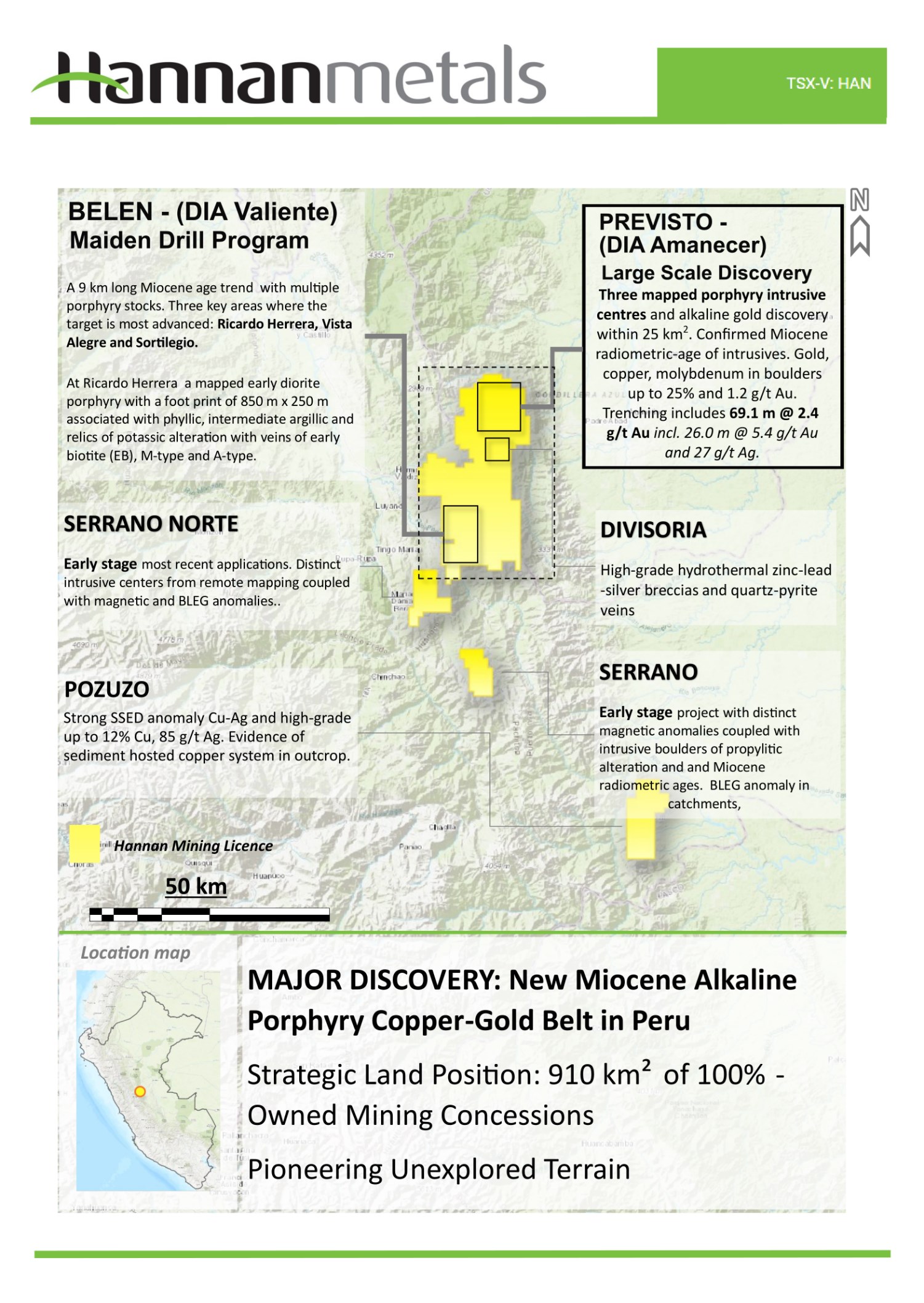
Figure 1: Overview of the 813 km2 Valiente project area in Peru.
To view an enhanced version of this graphic, please visit:
https://images.newsfilecorp.com/files/5402/293330_d11a0a8f248c3a87_002full.jpg
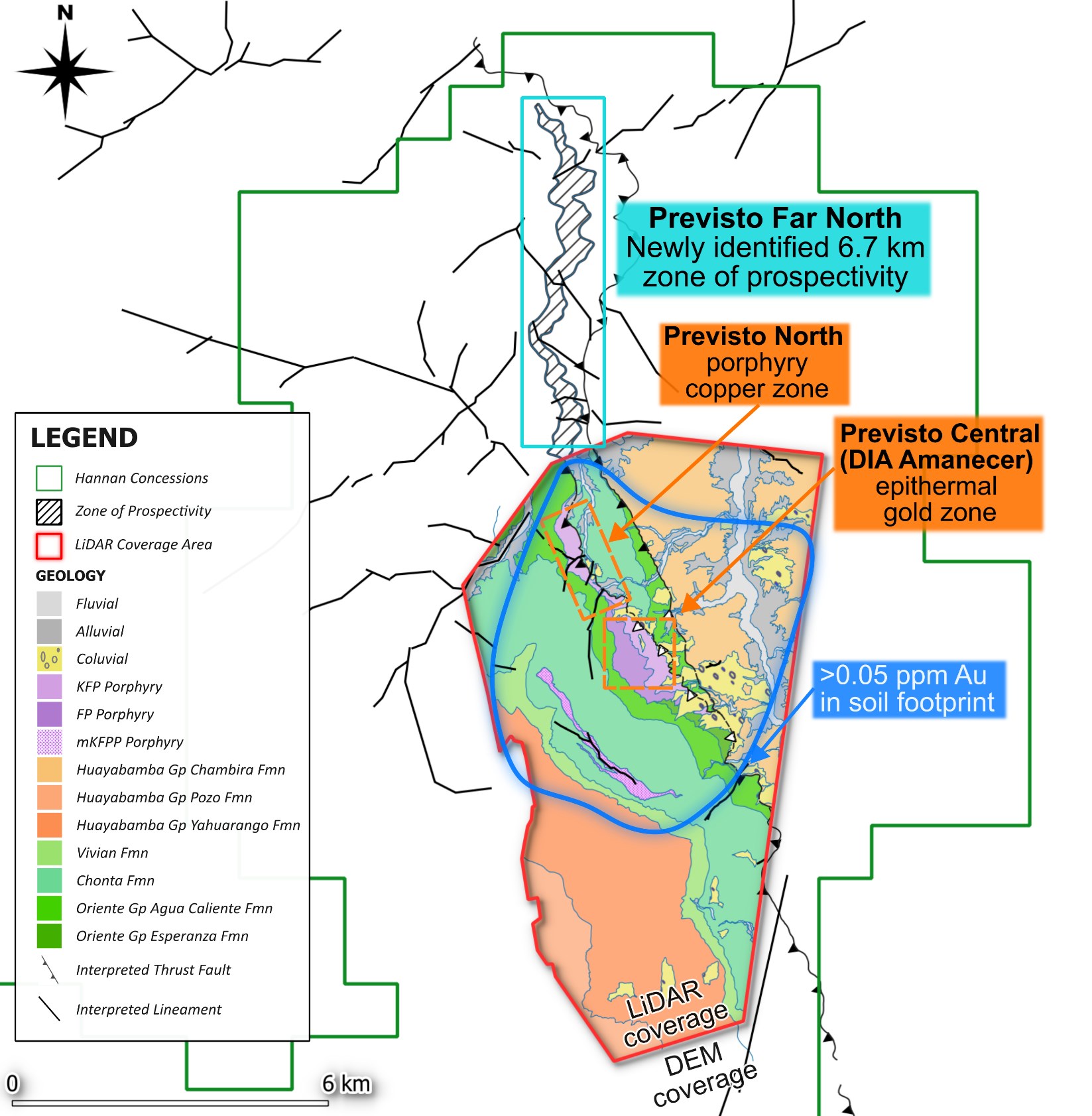
Figure 2: Geological map created with photogrammetry and high-resolution LiDAR data, showing newly defined area of prospectivity extending north.
To view an enhanced version of this graphic, please visit:
https://images.newsfilecorp.com/files/5402/293330_d11a0a8f248c3a87_003full.jpg

To view the source version of this press release, please visit https://www.newsfilecorp.com/release/293330
FAQ
AI-generated questions and answers. How Rhea-AI works. Not financial advice.