
Homeland Continues to Extend Near-Surface Anomalous Radioactivity at Coyote Basin Uranium Project
Rhea-AI Summary
Homeland Uranium (OTCQB: HLUCF) reported Phase II RC drilling at the 100% owned Coyote Basin project has confirmed near-surface anomalous radioactivity across an area ~1,000 m by 600 m and remains open for expansion. Approximately 3,400 m of 5,300 m planned (≈64%) have been completed. Radiometric responses occur at shallow depths, typically ~50–100 m. Geochemical samples were sent to SGS Lakefield for assays; chemical assays are required because uranium disequilibrium and discrepancies between downhole spectral gamma and portable XRF were observed.
Positive
- Anomalous radioactivity confirmed across ~1,000 m by 600 m
- Completed ~3,400 m of planned 5,300 m (≈64%) Phase II drilling
- Radiometric horizons occur at shallow depths of ~50–100 m
Negative
- No chemical assay results reported yet; uranium grades unknown
- Evidence of uranium disequilibrium causing uncertainty in gamma conversions
- Discrepancies between downhole spectral gamma and portable XRF readings
News Market Reaction – HLUCF
In the Jan 8 session, HLUCF gained 1.01%, reflecting a mild positive market reaction.
Data tracked by StockTitan Argus on the day of publication.
AI-generated analysis. How Rhea-AI works. Not financial advice.




Elevated radioactivity confirmed over an area measuring approximately 1,000 m by 600 m and remains open for expansion.
Vancouver, British Columbia--(Newsfile Corp. - January 8, 2026) - Homeland Uranium Corp. (TSXV: HLU) (OTCQB: HLUCF) (FSE: D3U) ("Homeland" or the "Company") is pleased to provide a third update on the Phase II exploration drilling program at the
An additional eight Reverse Circulation (RC) drillholes, CB-RC-0035 to CB-RC-0042, have been completed as part of the ongoing Phase II drill program (see Figure 2). Based on drilling completed to date, elevated radioactivity has now been confirmed over an area measuring approximately 1,000 m (3,280 ft) by 600 m (1,968 ft) and remains open for expansion. Approximately 3,400 m (11,155 ft) of the planned 5,300 m (17,388 ft) of the Phase II drilling program have been completed to date, representing roughly
Drillholes CB-RC-0035 to CB-RC-0040 (see Figure 2) were completed on a single east-west oriented drill fence located approximately 200 m (656 ft) south of the previously reported drilling, continuing the systematic step-out approach designed to evaluate the lateral extent of anomalous radioactivity across the Project area (see the Company's news release dated December 22, 2025 available at https://www.homeland-uranium.com/news-releases/2025/homeland-confirms-southward-continuity-of-anomalous-radioact2025-12-22-010502 or at the Company's profile on SEDARplus.ca).
Downhole Spectral Gamma Ray Counts Per Second readings from these most recent drillholes continue to demonstrate the presence of elevated radioactivity occurring at relatively shallow depths, typically between approximately 50 and 100 m (164-328 ft) below surface. The radiometric response and rock-types observed on this drill fence are consistent with earlier drilling, as anomalous radioactivity continues to be associated with shales, claystones, and fine-grained sandstones of the Upper Member of the Fort Union Formation.
Drillholes CB-RC-0041 and CB-RC-0042 (Figure 2), which comprise part of the planned southernmost east-west drill fence, also continue to exhibit elevated radioactivity at shallow depths in the south-western portion of the current drill area. This suggests that the anomalous horizon persists toward the southern extent of the currently tested area and supports the interpretation of a laterally extensive anomalous horizon.
Roger Lemaitre, President and CEO, Homeland Uranium stated, "The completion of this third fence of drilling further demonstrates the scale and continuity of near-surface anomalous radioactivity at Coyote Basin providing additional confidence in the geological interpretation of the presence of a laterally extensive horizon that remains open for further evaluation. As have we restarted the drilling program after the holidays, our focus remains on systematically expanding the footprint of this system while advancing geochemical analysis to better characterize the uranium mineralization."
Geochemical samples collected from the completed drillholes have been shipped to SGS Laboratories in Lakefield, Ontario, for analysis. Homeland will report geochemical and assay results once they have been received, compiled, and reviewed by the Company.
It is not uncommon for uranium mineralization within sandstone-hosted uranium deposits to be in disequilibrium with the daughter products of the radioactive decay series (see the Quality Assurance/Quality Control section below). While downhole gamma logging is often an effective tool for defining radiometric horizons and correlating with historical drilling, it has been determined that chemical assays will be required before uranium grades can be accurately determined. Ongoing drilling and geochemical analysis will support refinement of the geological model and improved characterization of uranium mineralization.
Quality Assurance/Quality Control
All drillholes are radiometrically logged using a calibrated QL40 SGR Spectral Gamma Ray downhole probe, which collects continuous spectral gamma measurements along the length of the drillhole. Gamma values are collected and reported as Counts Per Second are collected. The probe response is calibrated using coefficients derived from the probe's most recent factory calibration and through comparison of probe responses to geochemical assay data from previously sampled intervals.
Spectral gamma tools measure natural radioactivity, and in situations where the uranium decay series is in equilibrium, such gamma readings can be converted into equivalent concentrations of uranium, thorium, and potassium. However, if the uranium decay series is not in equilibrium, conversion of spectral gamma into equivalent concentrations of uranium may not be accurate, a phenomenon known as uranium disequilibrium. Uranium disequilibrium has been documented to occur at the nearby former producing Maybelle Uranium Mine, located approximately 29 km (18 miles) northeast of the Coyote Basin Project (see Global Uranium & Enrichment's news release dated July 29, 2025 which can be found at https://wcsecure.weblink.com.au/pdf/GUE/02972557.pdf ).
As a first step in determining the accuracy of QL40 SGR Spectral Gamma Ray downhole probe and determining whether uranium disequilibrium may occur at Coyote Basin, Homeland's geological team used a portable hand-held XRF (SciAps X-555 REE Analyzer) to test drill cuttings for the presence of uranium. Enough discrepancies have occurred when comparing the results of the Spectral Gamma Ray downhole probe and the XRF that additional geochemical and assay sampling will be required before uranium grades can be accurately determined.
Homeland has collected samples from each 5 ft interval of the drill holes for geochemical analysis which will be sent to SGS Laboratories in Lakefield, Ontario. SGS Lab is certified ISO 17043: General requirements for proficiency testing. All SGS laboratories are required to participate in SGS's internal Proficiency Testing (PT) program: Laboratory Quality Systems International (LQSi) program, the largest PT program in the mining world. The SGS LQSi program currently involves over 100 laboratories on a regular basis, both SGS and non-SGS participants. SGS LQSi holds accreditation to the conformity assessment standard ISO 17043: General requirements for proficiency testing.
All depths and intervals reported are drilled depths and downhole lengths, unless otherwise stated. True thicknesses have not yet been determined.
About Homeland Uranium Corp.
Homeland Uranium is a mineral exploration company focused on becoming a premier US-focused and resource-bearing uranium explorer and developer. The Company is
The Coyote Basin Project is reported by Energy Metals Corporation in its quarterly Management Discussion and Analysis dated September 30, 2006 filed with the Securities and Exchange Commission ("SEC") to contain an estimated historical resource of 8,850,000 tons grading
The Company is not treating the Coyote Basin historical resource estimate as current mineral resources and the reader is cautioned not to rely on either of these estimates. A Qualified Person (as defined under National Instrument 43-101 - Standards of Disclosure for Mineral Projects ("NI 43-101")) has not done sufficient work to classify the historical resources from the project as current mineral resources or mineral reserves nor can the Company or the Qualified Person comment on the quality or verify the data obtained from the assay sampling programs from the project that were used to determine these historical resource estimates, as such information was not included in the historical reports acquired by Homeland. The Company is not treating the historical resource estimate as current mineral resources or mineral reserves and the Company and the Qualified Person is unable to compare the historical resource estimate to the CIM's current resource classification system at this time. The Coyote Basin Project any future NI 43-101 mineral resource estimate will require considerable further evaluation which will include completion of the Phase I drilling program and may require addition drilling to follow-up Phase 1 results.
Qualified Person
Nancy Normore., P.Geo., the Company's Vice President, Exploration, is a Qualified Person as defined in NI 43-101, and has reviewed and approved the technical content of this news release.
For further information, please contact:
Roger Lemaitre
President & Chief Executive Officer
Homeland Uranium Corp.
Tel: 306-713-1401
Email: info@homeland-uranium.com
Investor Relations
Kin Communications Inc.
Tel: 604-684-6730
Email: HLU@kincommunications.com
Neither the TSX Venture Exchange nor its Regulation Services Provider (as that term is defined in the policies of the TSX Venture Exchange) accepts responsibility for the adequacy or accuracy of this news release.
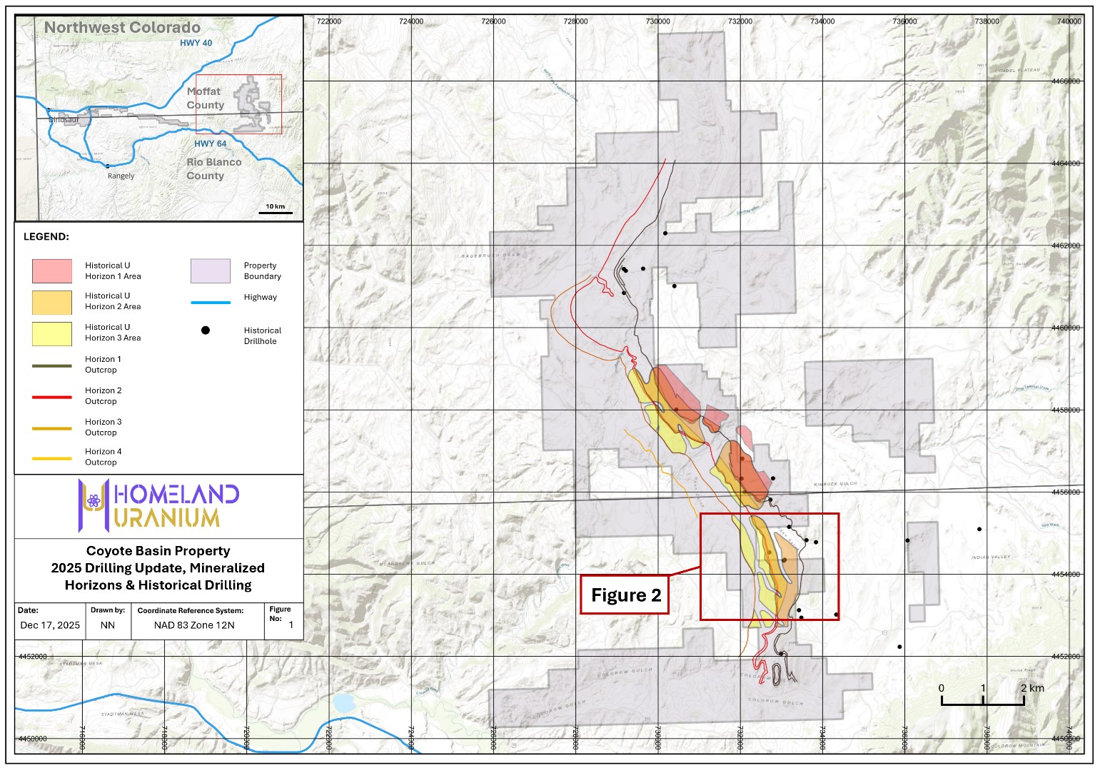
Figure 1 - Location of Homeland Uranium's Coyote Basin Project
To view an enhanced version of this graphic, please visit:
https://images.newsfilecorp.com/files/10583/279779_dc1f11f0a43e3b39_002full.jpg
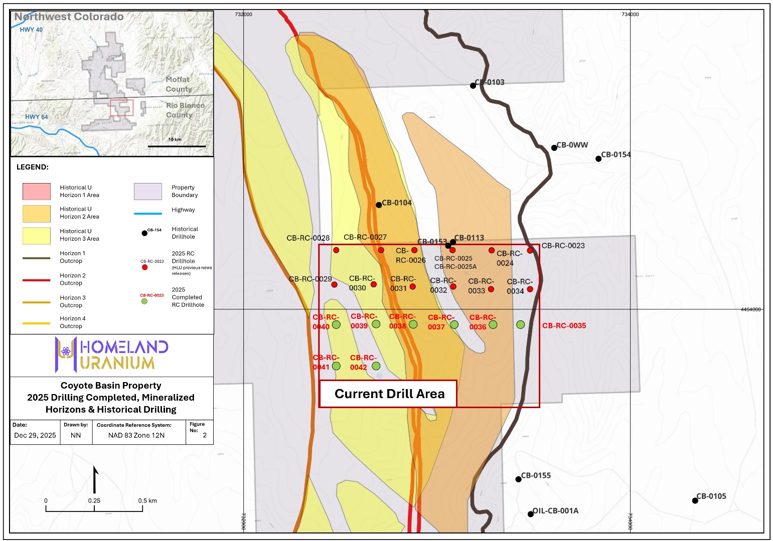
Figure 2 - Completed drillholes during Part 1 of Phase 2 - Coyote Basin Project
To view an enhanced version of this graphic, please visit:
https://images.newsfilecorp.com/files/10583/279779_dc1f11f0a43e3b39_003full.jpg

To view the source version of this press release, please visit https://www.newsfilecorp.com/release/279779