
Myriad Uranium Commences Phase II Drilling at Copper Mountain
Rhea-AI Summary
Myriad Uranium (OTCQB: MYRUF) has begun Phase II drilling at the Copper Mountain uranium project in Wyoming. Initial holes target Lucky Cliff, a historically drilled but underexplored zone outside the Bendix Assessment Area.
Phase II will also test areas hosting historical resource estimates of 26.6 Mlbs eU3O8 and new geophysical targets, and aims to support a current NI 43-101 mineral resource. A 1982 Bendix study outlined a conceptual exploration target of 245–655 Mlbs eU3O8. The company also highlights a pending merger with Rush to consolidate 100% of Copper Mountain, a planned uplisting to a major US exchange, and advancement of its Red Basin and Arizona breccia pipe projects.
Positive
- Phase II drilling underway at Copper Mountain uranium project in Wyoming
- Initial drilling at Lucky Cliff following strong historical uranium intersections
- Historical estimates total 26.6 Mlbs eU3O8 at 171 ppm eU3O8 (not current resources)
- 1982 Bendix conceptual exploration target of 245–655 Mlbs eU3O8
- Program designed to support a new NI 43-101 mineral resource estimate
- Merger with Rush expected to consolidate 100% ownership of Copper Mountain
Negative
- All Copper Mountain uranium quantities are historical or conceptual, not current resources
- Insufficient exploration to classify historical estimates as NI 43-101 mineral resources
- Company has not verified original historic drill data or QAQC records
- Fracture-hosted mineralization makes resource estimation less reliable from drill data
- Re-drilling campaign required before restating resources as current under NI 43-101
News Market Reaction – MYRUF
In the Jul 2 session, MYRUF declined 12.95%, reflecting a significant negative market reaction.
Data tracked by StockTitan Argus on the day of publication.
AI-generated analysis. How Rhea-AI works. Not financial advice.




Vancouver, British Columbia--(Newsfile Corp. - July 2, 2026) - Myriad Uranium Corp. (CSE: M) (OTCQB: MYRUF) (FSE: C3Q) ("Myriad" or the "Company") is pleased to announce that Phase II drilling at the Copper Mountain Uranium Project in Wyoming has commenced.
Highlights
Phase II drilling is now underway at the Copper Mountain Uranium Project in Wyoming. The first four holes will test mineralization at Lucky Cliff, a high-priority target area drilled by Union Pacific in the late 1970s and never followed up with modern techniques (see Figure 3).
Any mineralization confirmed at Lucky Cliff will be outside the 1982 U.S. DOE Bendix Engineering Report "Assessment Area" ("the Bendix Report") previously reported here (see Figure 1).
Once the holes at Lucky Cliff are complete, the Phase II program will turn to drilling areas, other than Canning, that are associated with historical resource estimates totalling 26.63 Mlbs eU3O8 contained in 44.1 Mt at an average grade of 171 ppm eU3O8, which are not being treated as current mineral resources or mineral reserves (see note about Historical Estimates below).
Canning contains roughly half of the historically estimated resources at Copper Mountain and was the focus of Myriad's highly successful 34-hole Phase I drill program in late 2024 (release here).
Phase II will also test new targets identified by our recent geophysics (release here), which have undergone verification by ground truthing using a hand-held gamma spectrometer.
The final stage of Phase II will be infill drilling to support a current mineral resource estimate under NI 43-101.
In 1982, Bendix Engineering for the U.S. Dept. of Energy reported an exploration target for Copper Mountain of 245 to 655 Mlbs eU3O8 contained within 1,111 Mt to 2,971 Mt (at 100 ppm eU3O8) and 222 Mt to 594 Mt (at 500 ppm eU3O8). Reported here and here (see Figure 1 and details below).
The potential tonnages and grades of the Bendix exploration target are conceptual in nature and are based on previous drill results and there has been insufficient exploration to define a current mineral resource, and it is uncertain if further exploration will result in the target being delineated as a mineral resource. See the section titled "Copper Mountain Exploration Target" below for more details.
Myriad's CEO, Thomas Lamb, commented: "Our aim for Phase II drilling will be to confirm mineralization, not just at the historically estimated areas of Copper Mountain, but also at entirely new targets identified through our successful geophysics programs and subsequent ground truthing. We also hope that Phase II, once complete, will provide support for a compelling current mineral resource estimate."
Mr. Lamb continued: "Beyond Phase II drilling, Myriad has a fast-moving and exciting 12 months ahead.
- Our merger with Rush is in the final steps of completion and will consolidate
100% ownership of Copper Mountain. This will have many benefits, including increasing our market cap, attracting institutional investor interest, simplifying operational decision-making, and broadening access to financing. - We plan to uplist to a major U.S. exchange.
- 8VC-backed Subatomic will be advancing the Red Basin, NM project, in which we hold a
10% free carried interest (release here). - Exploration of our Breccia Pipe Project in Arizona, which includes the Wate Pipe's high grade historical resource estimate, will commence (release here)."
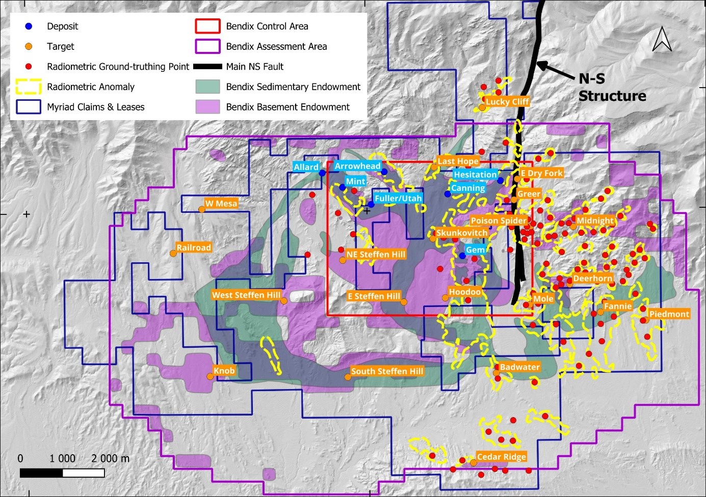
Figure 1: Target positions relative to the Bendix Assessment area.
To view an enhanced version of this graphic, please visit:
https://images.newsfilecorp.com/files/6301/303712_caea8a6de484c9fa_002full.jpg
Nasco Industrial Services and Supply (NISS) has deployed a Boart Longyear LF90D surface diamond core drill rig to Copper Mountain. The LF90D is a powerful, highly mobile surface diamond core drill rig known for its deep coring capacity and reliable hydraulic systems. It features a telescopic mast designed for both 3-metre (10 ft) and 6-metre (20 ft) rod pulls (Figure 2).
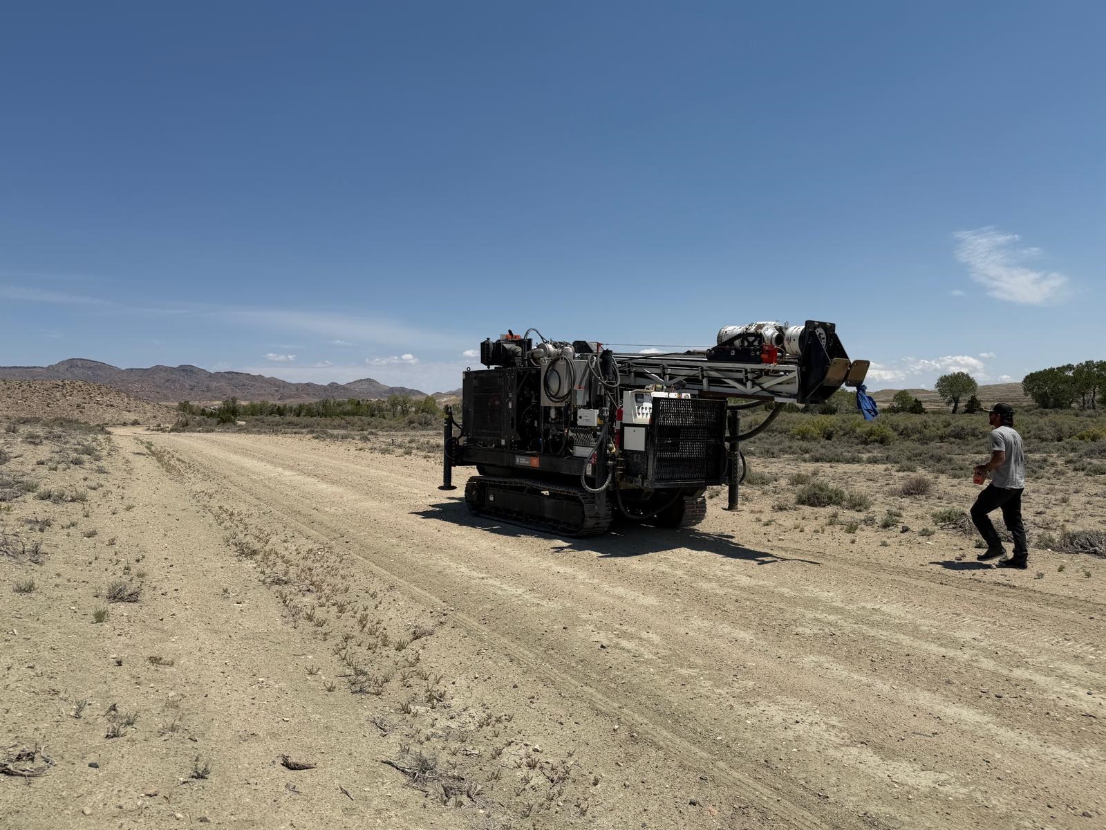
Figure 2: The Boart Longyear LF90D surface diamond core drill rig tramming to the project area at Copper Mountain.
To view an enhanced version of this graphic, please visit:
https://images.newsfilecorp.com/files/6301/303712_caea8a6de484c9fa_003full.jpg
Lucky Cliff
Lucky Cliff is located about 2000 metres (6,500 feet) north of the Canning deposit, along the Myrtle's Fault trend. The target area was selected by Union Pacific as a drill target on the basis of favourable geological and geochemical criteria. Several strong N45°E structural trends are present, and the associated rock types are similar to those found at other mineralized occurrences in the project area. A close-spaced (500-foot center) stream sediment sampling program undertaken by Union Pacific identified several highly anomalous (to 118 ppm) zones, and follow-up work was designed to test these anomalies. Ground-truthing of radiometric anomalies by Myriad following the helicopter survey completed late last year identified one point above the target area with a surface measurement of 193.2 ppm eU, using a calibrated RS-230 Handheld Gamma-Ray Spectrometer. Handheld spectrometer readings are preliminary and indicative only, may be affected by environmental and geometric factors, are not assay results and may not be representative of uranium concentrations in rock samples.
At least twenty holes were drilled by Union Pacific in the late 1970s. At least 10 holes intersected mineralisation in excess of 100 ppm eU3O8 from depths as shallow as 20 ft (6 m). LK-9 intersected 355 ft of
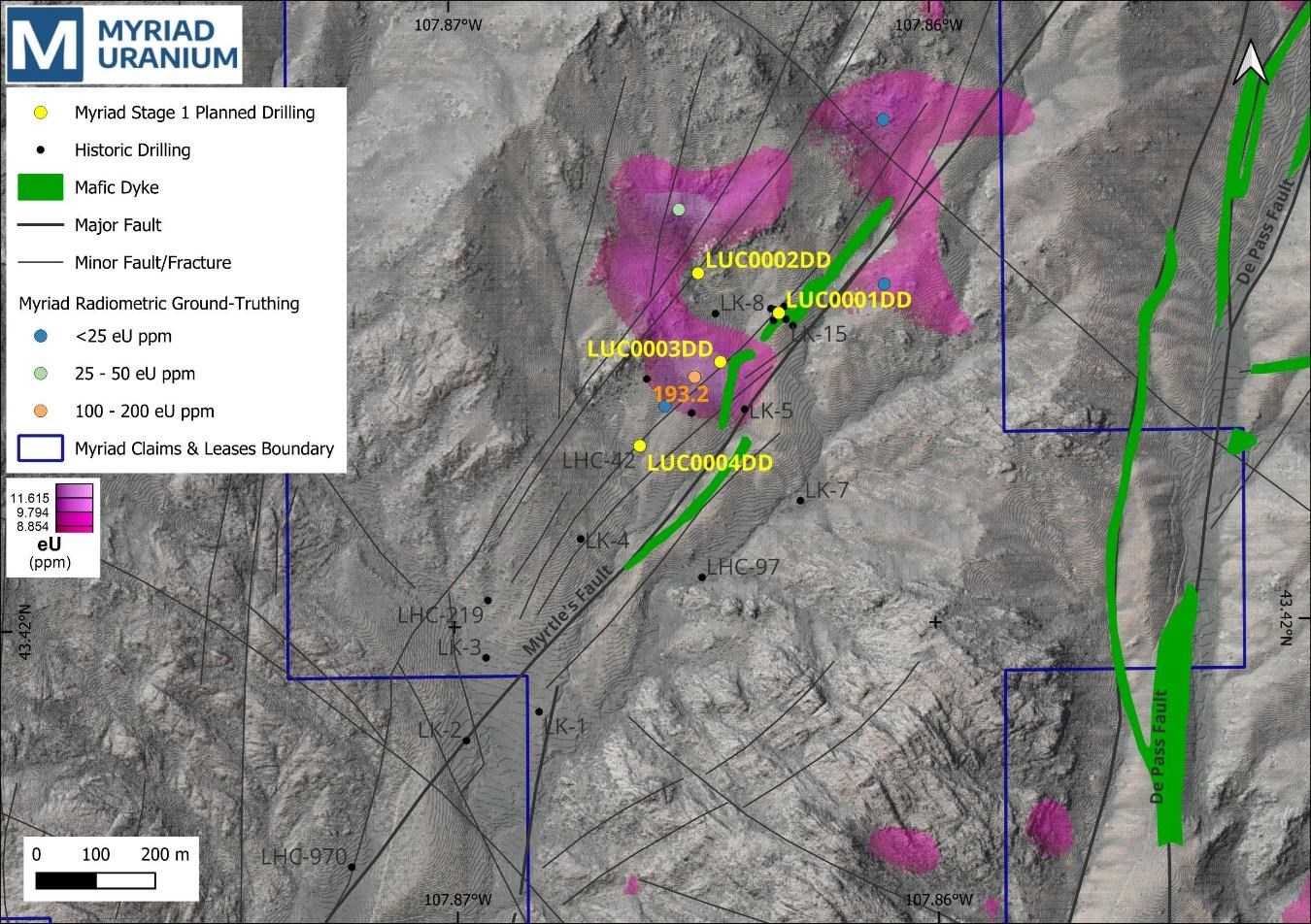
Figure 3: Planned drilling at Lucky Cliff. The purple shaded areas represent anomalous surface uranium measurements from Myriad's recent helicopter radiometric survey.
To view an enhanced version of this graphic, please visit:
https://images.newsfilecorp.com/files/6301/303712_caea8a6de484c9fa_004full.jpg
Copper Mountain Exploration Target
In 1982, Bendix Field Engineering Corp. ("Bendix") identified an exploration target of 245 to 655 Mlbs eU3O8 contained within 1,111 Mt to 2,971 Mt (at 100 ppm eU3O8) and 222 Mt to 594 Mt (at 500 ppm eU3O8). This was based on previous exploration on the property by Union Pacific Corp. and Bendix own work, including data from over 1,370 historic drill holes. The exploration target and methodology were detailed in two reports by Bendix titled "An Exploration Systems Approach to the Copper Mountain Area Uranium Deposits, Central Wyoming (September 1982)" and "Copper Fountain, Wyoming, Intermediate-Grade Uranium Resource Assessment Project Final Report (September 1982)", respectively. The exploration target potential was derived from geologic reconnaissance and geochemical, geophysical, petrologic, borehole, and structural data interpretations that were used to develop a genetic model for uranium mineralization in these environments. Development of a structural scoring system and application of models in a high-confidence control area established the basis for estimations of the uranium target in the total assessment area covering approximately 39.6 square miles. The volume of the modeled areas determines the potential tonnage statement in the exploration target. The grade range given in the exploration target is determined with consideration to the drill results within the modeled exploration target area and consideration of the geological setting in an established exploration camp. The potential tonnages and grades are conceptual in nature and are based on previous drill results that defined the approximate length, thickness, depth and grade of the portion of the historic mineral resource estimate. There has been insufficient exploration to define a current mineral resource, and it is uncertain if further exploration will result in the target being delineated as a mineral resource. Further details are available in the current NI 43-101 Technical Report.
Historical Resource Estimates
The historically estimated resources totalling 26.6 Mlbs eU3O8 contained in 44.1 Mt at an average grade of 171 ppm eU3O8 (using 100 ppm cut-off) were compiled from internal progress reports produced by Union Pacific subsidiary, Rocky Mountain Energy Company. In particular, a report titled "Copper Mountain Exploration Project Report" prepared by Southard, G.G., et. al., (1979) for Rocky Mountain Energy Company. The estimates were completed using polygonal methods based on modelled mineralization geometries. The historic resources were classified as Inferred and Indicated using U.S. Bureau of Mines categories at the time and do not necessarily correspond with the resource categories defined by current NI 43-101 definitions and guidelines. Details of the historical resource estimates are available in the current NI 43-101 Technical Report.
While Myriad Uranium has determined that the historical estimates described in this news release are relevant to the Copper Mountain Project Area and are reasonably reliable given the authors and circumstances of their preparation, and are suitable for public disclosure, readers are cautioned to not place undue reliance on these historical estimates as an indicator of current mineral resources or mineral reserves at the Project Area. A qualified person (as defined under NI 43-101) has not done sufficient work to classify any of the historical estimates as current mineral resources or mineral reserves, and Myriad Uranium is not treating the historical estimates as a current mineral resource or mineral reserve. Also, while the Copper Mountain Project Area contains all or most of each deposit referred to, some of the resources referred to may be located outside the current Copper Mountain Project Area. Furthermore, the estimates are decades old and based on drilling data for which the logs are, as of yet, predominantly unavailable. The historical resource estimates, therefore, should not be unduly relied upon.
Inherent limitations of the historical estimates include that the nature of mineralization (fracture hosted) makes estimation from drill data less reliable than other deposit types (e.g. those that are thick and uniform). From Myriad Uranium's viewpoint, limitations include that the Company has not been able to verify the original data itself and that the estimates may be optimistic relative to subsequent work which applied a "delayed fission neutron" (DFN) factor to calculate grades. On the other hand, DFN is controversial, in that the approach is viewed by some experts as too conservative. Nevertheless, it was applied in later resource estimations by Union Pacific relating to Copper Mountain. To verify the historical estimates and re-state them as current resources, a program of re-drilling is required to generate new data that can be used to establish the correlation and continuity of geology and grades between boreholes with sufficient confidence to estimate mineral resources.
Qualified Person
The scientific and technical information in this news release has been reviewed and approved by George van der Walt, MSc., Pr.Sci.Nat., FGSSA, a "Qualified Person" as defined under NI 43-101. Mr. van der Walt is a Principal Consultant with The MSA Group (Pty) Ltd, an independent consultancy. A Qualified Person has not done sufficient work to verify historic exploration results or to classify the historical estimates referred to in this news release as current mineral resources or mineral reserves, and Myriad is not treating such historical estimates as current mineral resources or mineral reserves.
About Myriad Uranium Corp.
Myriad Uranium Corp. holds a
A news release detailing a comprehensive assessment of Copper Mountain's uranium endowment by Bendix Engineering for the US Department of Energy published in 1982 can be viewed here.
Myriad holds a
Myriad's
Note: A qualified person has not done sufficient work to classify the Copper Mountain, Red Basin, and Breccia Pipe Project historical estimates as current mineral resources or reserves and Myriad is not treating historical estimates as current resources or reserves. Myriad intends to conduct further work to determine whether the historical estimates can be verified and, if appropriate, supported by current mineral resource estimates.
For further information, please refer to Myriad's disclosure record on SEDAR+ (www.sedarplus.ca), contact Myriad by telephone at +1.604.418.2877, or refer to Myriad's website at www.myriaduranium.com.
Myriad Contacts:
Thomas Lamb
President and CEO
tlamb@myriaduranium.com
Forward-Looking Statements
This news release contains "forward-looking information" that is based on the Company's current expectations, estimates, forecasts and projections. This forward-looking information includes, among other things, the Company's business, plans, outlook and business strategy. The words "may", "would", "could", "should", "will", "likely", "expect", "anticipate", "intend", "estimate", "plan", "forecast", "project" and "believe" or other similar words and phrases are intended to identify forward-looking information. The reader is cautioned that assumptions used in the preparation of any forward-looking information may prove to be incorrect, including with respect to the Company's business plans respecting the exploration and development of the Company's mineral properties, the proposed work program on the Company's mineral properties and the potential and economic viability of the Company's mineral properties. Forward-looking information is subject to known and unknown risks, uncertainties and other factors that may cause the Company's actual results, level of activity, performance or achievements to be materially different from those expressed or implied by such forward-looking information. Such factors include, but are not limited to: inability to verify historical data, no assurance of defining mineral resources, permitting, drilling delays and changes in economic conditions or financial markets; increases in costs; litigation; legislative, environmental and other judicial, regulatory, political and competitive developments; and technological or operational difficulties. This list is not exhaustive of the factors that may affect our forward-looking information. These and other factors should be considered carefully, and readers should not place undue reliance on such forward-looking information. The Company does not intend, and expressly disclaims any intention or obligation to, update or revise any forward-looking information whether as a result of new information, future events or otherwise, except as required by applicable law.
The CSE has not reviewed, approved or disapproved the contents of this news release.
To view the source version of this press release, please visit https://www.newsfilecorp.com/release/303712