
GeoCue Elevates Survey-Grade Drone Mapping with Ouster's BABA-Compliant Native Color Rev8 Digital Lidar
GeoCue’s TrueView drone mapping will add BABA-compliant Ouster Rev8 OS1 Max lidar, with a 200 m (at 10% reflectivity) range supporting higher-altitude utility corridor surveys.
Sentiment and the balance of points
Rhea-AI Sentiment reads the wording of the document, how positive or negative its language is on a 1 to 5 scale. The balance of points shown with the takes weighs what the document actually discloses, so the two can disagree, for example when a trial that missed its main goal is described in upbeat language.




Pairing survey-grade precision with Ouster’s 256-channel Rev8 OS1 Max lidar, GeoCue’s latest TrueView lineup sets a new benchmark for
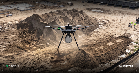
Ouster Rev8 OS1 Max on GeoCue's TrueView drone payload, mapping a construction site (product rendering).
GeoCue is expanding its TrueView lineup to include options featuring the Ouster Rev8 OS1 Max, which is Build America, Buy America Act (BABA)-compliant. These new options give customers who have domestic production requirements a high-performance solution without technical compromises.
Ouster and GeoCue selected the Rev8 OS1 Max after joint flight testing and firmware tuning in
The Rev8 OS1 Max brings four key advantages to GeoCue's utility and infrastructure customers:
- Superior Precision: A smaller spot size and tighter beam allow TrueView payloads to resolve thin objects such as power lines and structural edges.
-
Expanded Operational Range: Longer range (200m at
10% reflectivity) clears altitude restrictions around utility corridors, letting operators fly higher while maintaining data quality. - Native Color Integration: The Rev8 OS1 Max captures native color in addition to 3D lidar data, so every point arrives inherently aligned to its color. Alongside the dual cameras in every TrueView payload, that gives LP360 an additional RGB reference for registering camera imagery to the point cloud, enabling tighter sensor fusion.
- Density at Speed: 256 channels in 2K and 4K modes keep point density high even at fast flight speeds, supporting long-corridor surveys by propeller and fixed-wing aircraft.
"Our partnership with GeoCue is a testament to how native color digital lidar can serve as the bedrock for physical AI applications that have a profound impact on infrastructure and public safety," said Ouster CEO Angus Pacala. "By integrating our Rev8 OS1 Max sensor, we are providing the survey-grade precision and reliability required to empower the next generation of drone mapping professionals."
Experience the Rev8 OS1 Max for Drone Surveying at Commercial UAV Expo
Ouster will be showcasing its Rev8 OS1 Max native color digital lidar at Booth #1653 during the Commercial UAV Expo in
About Ouster
Ouster (Nasdaq: OUST) is a leader in sensing and perception for Physical AI across industrial, robotics, automotive, and smart infrastructure. With a unified platform of high-performance digital lidar, cameras, AI compute, sensor fusion and perception software, and AI models, Ouster delivers solutions that improve quality of life in the physical world. Headquartered in
About GeoCue
GeoCue brings geospatial professionals advanced drone, mobile and terrestrial surveying equipment, point-cloud processing software, workflows, training and support for high-accuracy LiDAR and imagery mapping. With TrueView LiDAR and imaging sensors and LP360 point-cloud processing software, GeoCue provides complete solutions for successful data collection, processing, quality control and deliverable creation. GeoCue meets customers where they are in terms of technology, adoption, budget and resources while supporting their continued growth. To learn more about GeoCue, visit www.geocue.com.
Forward-Looking Statements
This press release contains forward-looking statements within the meaning of the Private Securities Litigation Reform Act of 1995. The Company intends such forward-looking statements to be covered by the safe harbor provisions for forward-looking statements contained in Section 27A of the Securities Act of 1933, as amended and Section 21E of the Securities Exchange Act of 1934, as amended. Such statements are based upon current plans, estimates and expectations of management that are subject to various risks and uncertainties that could cause actual results to differ materially from such statements. The inclusion of forward-looking statements should not be regarded as a representation that such plans, estimates and expectations will be achieved. Words such as “anticipate,” “expect,” “intend,” “may,” “will,” “should,” “plan,” “could,” “estimate,” “possible,” “potential,” “pursue,” “likely,” and the negative of these terms and similar expressions are intended to identify forward-looking statements, though not all forward-looking statements use these words or expressions. All statements, other than statements of historical fact, including statements regarding the capabilities and applications of Ouster’s digital lidar, the anticipated performance, benefits to and expectations around customer adoption and application of our product offerings; Ouster’s competitive position, and the development of and demand for our products, all constitute forward-looking statements. All forward-looking statements are subject to risks and uncertainties that may cause actual results to differ materially from those that we expected, including, but not limited to, risks related to the adoption of the Company’s products ; product quality and liability risks; the Company’s dependence on key third party suppliers; Ouster’s ability to respond to evolving regulations and standards and other important factors discussed in the Company’s Annual Report on Form 10-K for the year ended December 31, 2025, and as may be further updated from time to time in the Company’s Quarterly Reports on Form 10-Q and other filings with the SEC. Readers are urged to consider these factors carefully and in the totality of the circumstances when evaluating these forward-looking statements, and not to place undue reliance on any of them. Any such forward-looking statements represent management’s reasonable estimates and beliefs as of the date of this press release. While Ouster may elect to update such forward-looking statements at some point in the future, it disclaims any obligation to do so, other than as may be required by law, even if subsequent events cause its views to change.
View source version on businesswire.com: https://www.businesswire.com/news/home/20260902576177/en/
Ouster:
For Investors
investors@ouster.io
For Media
press@ouster.io
GeoCue
press@geocue.com
Source: Ouster, Inc.