Powermax Minerals Identifies High-Priority Ree Targets at Atikokan Project, Northwestern Ontario
Rhea-AI Summary
Powermax Minerals (OTCQB: PWMXF) reported an integrated geoscientific desktop study on its Atikokan REE Property (9,416 ha) that delineated a NE–SW REE corridor along the White Otter Batholith–Dashwa Gneiss contact. OGS lake-sediment TREE values in Blocks B and C range from 254–1,947 ppm (mean ≈ 616 ppm), coincident with low gravity, subdued magnetics, and elevated Th/K and Th/U ratios. Block A shows TREE 339–1,111 ppm (mean ≈ 570 ppm) in low-gravity, low-magnetic corridors.
Powermax has started high-resolution airborne MAG/RAD surveys (≤100 m line spacing), detailed mapping and systematic surface sampling to prioritize drill-ready targets in Blocks B and C.
Positive
- TREE 254–1,947 ppm in Blocks B and C (mean ≈ 616 ppm)
- Block A TREE 339–1,111 ppm (mean ≈ 570 ppm) indicating localized potential
- NE–SW REE corridor defined along batholith–gneiss contact
- High-resolution MAG/RAD surveys underway to refine targets (≤100 m spacing)
Negative
- Results are desktop and surface data; no confirmed mineral resource reported yet
- Follow-up work (mapping, sampling, surveys) required before drill-ready targets
News Market Reaction – PWMXF
In the Nov 10 session, PWMXF declined 4.26%, reflecting a moderate negative market reaction.
Data tracked by StockTitan Argus on the day of publication.
AI-generated analysis. How Rhea-AI works. Not financial advice.
Toronto, Ontario--(Newsfile Corp. - November 10, 2025) - Powermax Minerals Inc. (CSE: PMAX) (OTCQB: PWMXF) (FSE: T23) ("Powermax" or the "Company") is pleased to announce the results of an integrated geoscientific interpretation completed on its Atikokan Rare Earth Element (REE) Property, located approximately 35 km northwest of Atikokan, Ontario. The study-conducted by Shahab Tavakoli, P.Geo., Geospatial Data Scientist and Geophysicist-integrates geological, geophysical, and geochemical datasets to delineate priority REE exploration targets across Blocks A, B, and C, covering a total of 9,416 hectares in the Thunder Bay Mining District.
The desktop study included historical airborne magnetic (MAG), Bouguer gravity (BG), and radiometric (RAD) data, together with Ontario Geological Survey (OGS) deep lake-sediment geochemistry—to delineate potential zones of elevated REE across the property.
Study Highlights
- Well-defined REE corridor delineated along batholith-gneiss contact: The integration of multiple datasets outlines a structural-geochemical corridor of REE enrichment along the contact between the White Otter Batholith and the Dashwa Gneissic Suite, a setting characterized by steep structural fabrics and fertile lithological contrasts conducive to REE-bearing alteration systems.
- Strong REE anomalies confirmed in Blocks B and C: The southern blocks returned Total Rare Earth Element (TREE) values from 254 to 1,947 ppm (mean ≈ 616 ppm) in OGS lake-sediment samples, coincident with low gravity, subdued magnetic susceptibility, and elevated Th/K (> 4.5-5.5) and Th/U (> 7.5-8.5) ratios. These attributes delineate a NE-SW trending mineralized corridor, interpreted to host phosphate-bearing, metasedimentary-hosted REE systems genetically linked to calc-alkaline granitic magmatism.
- Additional localized potential in Block A: Within the interior of the White Otter Batholith, moderately elevated TREE values (339-1,111 ppm; mean ≈ 570 ppm) occur along low-gravity, low-magnetic corridors, reflecting structurally controlled hydrothermal alteration zones and potential small-scale Th-REE-bearing pegmatitic systems.
Ongoing Exploration Program
Powermax has initiated the next phase of exploration, designed to validate and expand upon the desktop study results. The current program includes:
- High-resolution airborne magnetic and radiometric surveys (≤ 100 m line spacing) are now underway to refine the geometry of REE-bearing zones and identify additional structural trends (see Oct 21, 2025, news release);
- Detailed geological mapping and structural interpretation across the White Otter-Dashwa contact zone, targeting key alteration corridors and shear structures;
- Systematic surface sampling, including rock and soil sampling, to confirm REE-bearing phases such as monazite, allanite, xenotime, and fluorapatite identified in the desktop review (see Oct 16, 2025, news release); and
- Integration of new field data with existing regional geophysical and geochemical datasets to prioritize potential drill-ready targets for subsequent exploration phases.
The field results will be incorporated into the ongoing Atikokan REE exploration model, enhancing geological understanding and guiding follow-up work across the most promising zones within Blocks B and C.
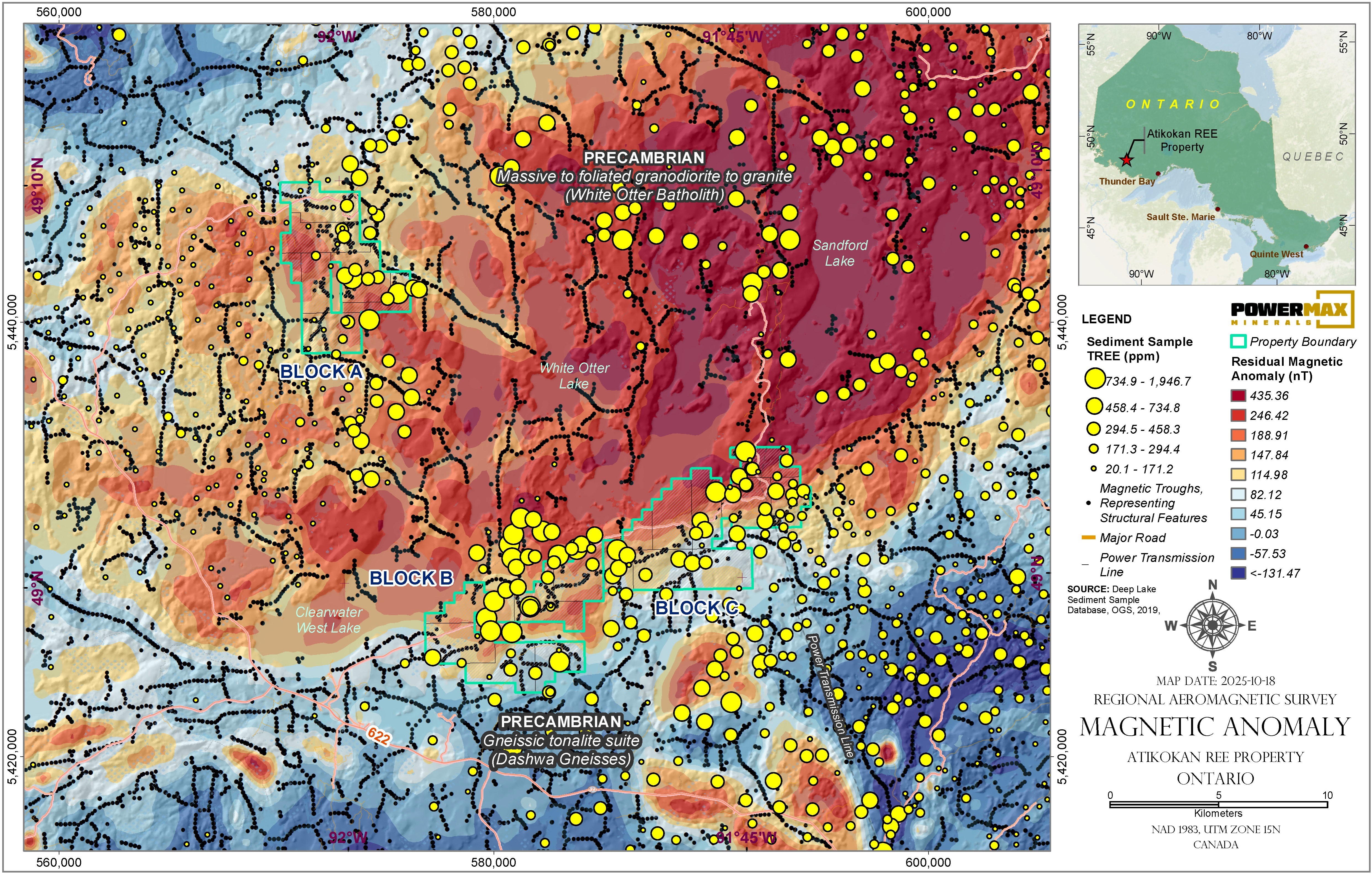
Figure 1: Map Showing Total REE in Lake Sediments and Residual Magnetic Anomaly (nT)
To view an enhanced version of this graphic, please visit:
https://images.newsfilecorp.com/files/11633/273780_69a2195164d8eaab_001full.jpg
CEO Comment
"We are very encouraged by the progress at Atikokan," said Paul Gorman, President and CEO of Powermax Minerals Ltd. "The desktop study provided a strong scientific basis for identifying REE-enriched corridors, and our active field program is now expanding on those findings. The integration of ground observations, geochemical assays, and high-resolution geophysics will allow us to rapidly advance toward defining specific targets for detailed follow-up exploration."
About the Atikokan REE Property
The Atikokan REE Property comprises three mineral claim blocks (A, B, and C) covering approximately 9,416 hectares in northwestern Ontario, located 35 km northwest of the town of Atikokan and 188 km west of Thunder Bay. The property is accessible year-round by a network of gravel and logging roads branching from Highways 622 and 11. Geologically, it is situated near the boundary between the Wabigoon and Quetico sub-provinces of the Archean Superior Province—an area known for fertile granitic intrusions, reactive metasedimentary rocks, and favorable structural corridors for REE and lithium-bearing pegmatite mineralization.
Qualified Person
The technical information contained in this news release has been reviewed and approved by Afzaal Pirzada, P.Geo., who is a director of the Company and a Qualified Person under National Instrument 43-101 — Standards of Disclosure for Mineral Projects.
On Behalf of the Board of Directors
Paul Gorman, CEO & Director
Email: info@powermaxminerals.com
Website: www.powermaxminerals.com
Tel: (416) 768-6101
About Powermax Minerals Inc.
Powermax Minerals Inc. is a Canadian mineral exploration company focused on advancing rare earth element projects. The Company holds an option to acquire the Cameron REE Property, comprising three mineral claims totaling approximately 2,984 hectares in British Columbia. Powermax also optioned to acquire the Atikokan REE Property, consisting of 455 unpatented mining claims in NW Ontario. Powermax also owns a
Forward-Looking Statements
This news release may contain 'forward-looking statements' within the meaning of applicable Canadian securities legislation. Forward-looking statements are based on current expectations and assumptions of management and are subject to known and unknown risks, uncertainties, and other factors that may cause actual results, performance, or achievements to differ materially from those expressed or implied. Such statements include, but are not limited to, statements regarding potential mineralization, exploration plans, timing of activities, and future exploration results. Readers are cautioned not to place undue reliance on these forward-looking statements. Powermax Minerals Inc. disclaims any intention or obligation to update or revise any forward-looking statements whether as a result of new information, future events, or otherwise, except as required by applicable securities laws.
Neither the Canadian Securities Exchange nor its Market Regulator (as defined in CSE policies) accepts responsibility for the adequacy or accuracy of this news release.
To view the source version of this press release, please visit https://www.newsfilecorp.com/release/273780