
Gordon Mining Enters into Definitive Agreement to Acquire the Tungsten Tail Project, Sierra County, New Mexico
The acquisition entails closing payments, milestone-linked consideration and a retained royalty on the exploration property.
Sentiment and the balance of points
Rhea-AI Sentiment reads the wording of the document, how positive or negative its language is on a 1 to 5 scale. The balance of points shown with the takes weighs what the document actually discloses, so the two can disagree, for example when a trial that missed its main goal is described in upbeat language.
Rhea-AI Summary
Gordon Mining Group (GSPFD) signed a definitive agreement with Lamina Minerals to acquire full ownership of the Tungsten Tail Project in New Mexico. The acquisition covers TT Minerals, which holds 41 claims spanning approximately 847 acres. Closing consideration is C$125,000 and 1,500,000 common shares, with additional cash or shares tied to permitting, drilling and resource milestones. Lamina will retain a 2.0% net smelter returns royalty; Gordon may repurchase half for US$1,000,000.
After closing, Gordon plans mapping, sampling, geophysical surveys and drill-permit applications to prepare drilling targets. Historical production and sampling data remain unverified by a Qualified Person, and no mineral resource has been estimated. Specific drill targets have not yet been defined. The corresponding transfer of claim interests with the U.S. Bureau of Land Management remains pending.
How this balance works
Rhea-AI gives every point it takes from this document a weight. Minor counts 1, Moderate 3 and Major 9, so one Major point outweighs several Minor ones. The bar adds up the weights on each side, and when neither side holds more than 65% of the total the balance reads Mixed.
It reads the document as published, with the same rules for every company, and it does not look at what the market expected or at how the stock traded, so a point can be objectively good on a day the stock falls.
Rhea-AI Sentiment measures something else, the tone of the wording.
Hollow bars mark forward-looking points. How the balance works
Positive
- Moderate pointDefinitive acquisition agreement covers 100% of TT Minerals and its Tungsten Tail Project.
- Minor point41 contiguous claims cover approximately 847 acres; maintenance fees are paid through the 2027 assessment year.
- Minor point. Forward-looking: it has not happened yet and may not happen.Post-closing exploration plans include mapping, sampling and geophysical surveys to prepare drilling targets.
- Minor point. Forward-looking: it has not happened yet and may not happen.Drill-permit applications are planned for a first program testing beneath the historical workings.
- Minor point. Forward-looking: it has not happened yet and may not happen.Royalty repurchase right allows Gordon to buy back 1.0% for US$1,000,000 at any time.
Negative
- Moderate point. Forward-looking: it has not happened yet and may not happen.Closing consideration requires C$125,000 cash and 1,500,000 common shares, adding cost and dilution.
- Minor point. Forward-looking: it has not happened yet and may not happen.2,000,000 additional shares are due upon receipt or deemed receipt of drill permits, subject to a 24-month post-closing deadline, extendable in limited circumstances.
- Minor point. Forward-looking: it has not happened yet and may not happen.500,000 additional shares are due after at least 1,000 metres of first-phase drilling, irrespective of assay results.
- Minor point. Forward-looking: it has not happened yet and may not happen.1,000,000 additional shares are due for a qualifying intersection of at least 10 metres true width averaging at least 0.7% WO₃.
- Minor point. Forward-looking: it has not happened yet and may not happen.C$500,000 resource milestone payment is payable in cash or, at Gordon's election, common shares upon the qualifying technical-report milestone.
4 minor points
- Minor point. Forward-looking: it has not happened yet and may not happen.2.0% net smelter returns royalty remains payable to the vendor on the Project and Area of Interest.
- Minor pointBLM transfer of interest corresponding to TT Minerals' recorded claim deed remains pending.
- Minor pointHistorical production, grades and geochemical results are unverified by a Qualified Person; no mineral resource has been estimated.
- Minor pointDrill targets remain undefined; Gordon plans permit applications to the U.S. Forest Service and New Mexico.
AI-generated analysis. How Rhea-AI works. Not financial advice.


Vancouver, British Columbia--(Newsfile Corp. - October 20, 2026) - Gordon Mining Group Inc. (CSE: GORD) (OTCQB: GSPFD) (FSE: L5Y) (formerly Golden Spike Resources Corp.) (the "Company" or "Gordon Mining") is pleased to announce that it has entered into a definitive agreement dated October 19, 2026 (the "Agreement") with Lamina Minerals LLC (the "Vendor") to acquire a
Highlights
Definitive agreement to acquire
100% of the Tungsten Tail Project: 41 contiguous unpatented lode claims (TT 1-41, approximately 847 acres or 343 hectares) covering the historical Tungsten Tail mine (formerly the Silver Tail mine) located in the Tierra Blanca mining district, Sierra County, New Mexico (see Figure 1) [1]. Tungsten is included on the U.S. Geological Survey ("USGS") list of critical minerals [2].Historical tungsten production: the Tungsten Tail mine shipped small quantities of scheelite-bearing mineralization in 1942, when operated by its then-owners Tauche and Bonnefoy, and in 1955, under a lease from owners J. H. and M. R. Schoonmaker to Plumball Mining Co., at owner-reported grades of approximately 3
-4% WO₃ (U.S. Bureau of Mines ("USBM") RI 5517; USGS Circular 808) [3][4][5].*Regional USGS geochemistry: USGS stream-sediment mapping (1978) traced a "nearly continuous" tungsten-molybdenum concentrate anomaly along the Pierce Canyon fault through the claim block, interpreted the signature as potentially indicating skarn mineralization at depth, and concluded that "the entire zone seems a good exploration target for deposits at depth" [6][7].*
Modern public geophysical data: in 2023 the USGS flew an airborne magnetic and radiometric survey at 200-metre line spacing over an area that includes the Project, and the data are publicly available (see Figure 2) [8]. The Company intends to interpret these data as part of its exploration planning.
Near-term plan: Gordon Mining intends to mobilize an exploration team to carry out geological mapping and sampling to prioritize targets for drilling.
* The production and grade figures and the regional geochemical results referred to in these highlights are historical, have not been verified by a Qualified Person and are not indicative of a current mineral resource. See the Historical Data Cautionary Statement below.
"Tungsten Tail gives Gordon Mining a tungsten exploration project in the United States with a documented history," said Ryan Connacher, President and Chief Executive Officer of Gordon Mining. "The mine shipped small quantities of tungsten mineralization in 1942 and 1955. A 1957 Bureau of Mines examination recommended further work, and in the late 1970s the USGS mapped and sampled the structure that crosses the Project and described the zone as a good exploration target for deposits at depth. We have found no record of any drilling on the Project."
"Several major mining companies held claims over this ground during the 1980s," added Mr. Connacher. "After closing, we start with field work: mapping and sampling the historical workings and the surrounding ground, and interpreting the 2023 USGS airborne survey. Ground geophysics and drill permitting follow. We intend to carry out the first recorded drill program on the Project."
Project and Location
The Tungsten Tail Project is located in southwestern New Mexico, in the Tierra Blanca mining district on the east flank of the Black Range, approximately 12 kilometres (7.5 miles) south-southeast of Kingston, 15 kilometres (9.3 miles) southwest of Hillsboro, 52 kilometres (32 miles) southwest of Truth or Consequences and 160 kilometres (100 miles) northwest of El Paso, Texas (Figure 1). The claims cover the historical Tungsten Tail mine (formerly the Silver Tail mine) and the central portion of the Pierce Canyon fault, a north-trending structure that USGS mapping traces for roughly ten kilometres, as well as the historical Jayhawk workings, a base-metal and silver prospect on the same structure recorded by the USGS [1][4][6][9].
The Project comprises 41 contiguous unpatented lode mining claims (TT 1-41) covering approximately 847 acres (343 hectares) in Sections 9, 10, 15, 16, 21 and 22, Township 17 South, Range 8 West, New Mexico Principal Meridian, Sierra County, on lands administered by the U.S. Forest Service (Gila National Forest, Black Range Ranger District). The claims were located in August 2026, filed with the U.S. Bureau of Land Management ("BLM") under serial numbers NM106841771 to NM106841811 and recorded in Sierra County. Maintenance fees have been paid through the 2027 assessment year. The claims are held by TT Minerals LLC under a quitclaim deed from Strata Mine Technologies Corp. recorded in Sierra County on October 16, 2026; the corresponding transfer of interest with the BLM is pending. BLM records indicate that several companies, including Homestake Mining and Phelps Dodge, held unpatented claims over parts of the area now covered by the Project between 1980 and 2015 [10].
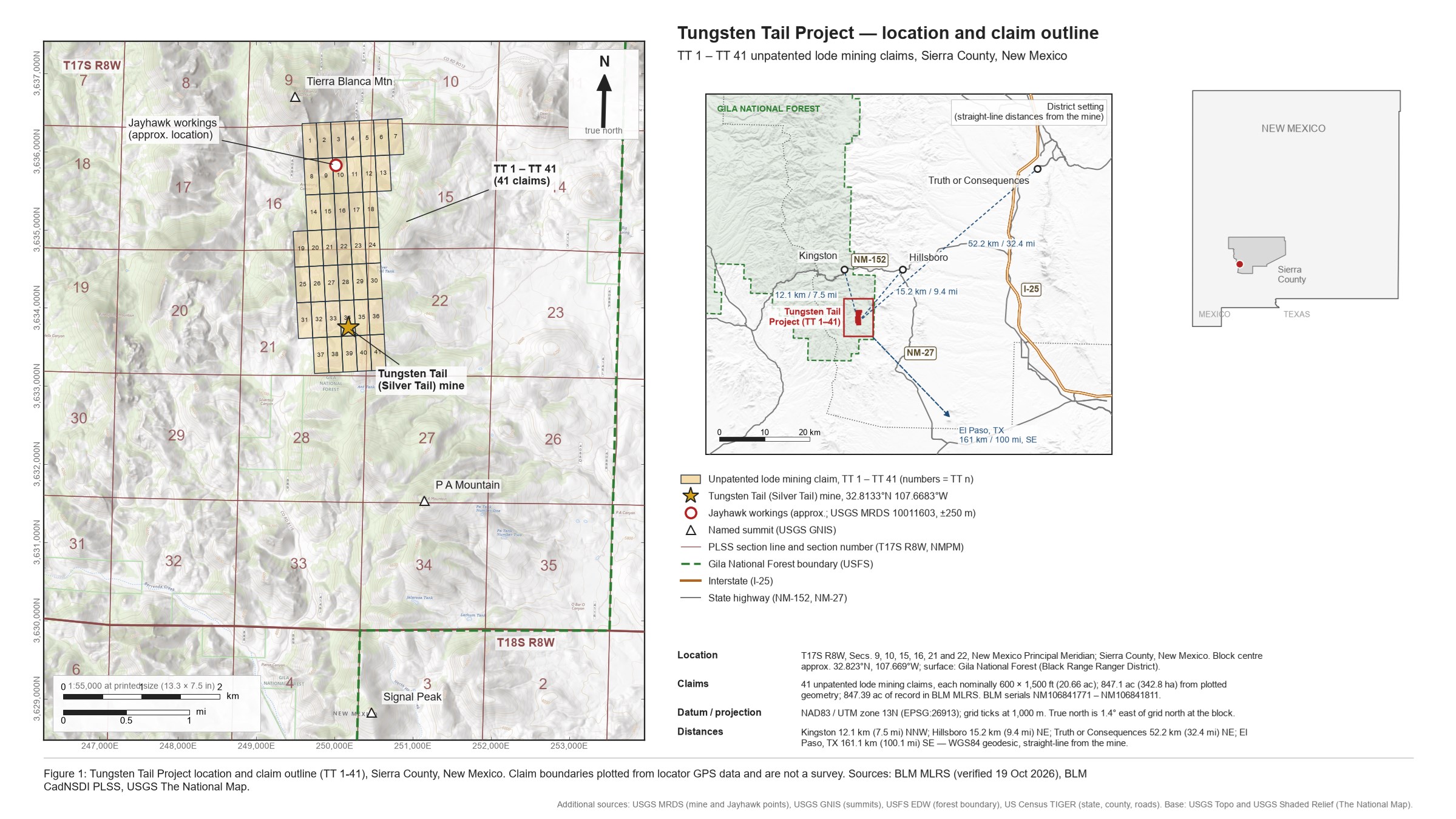
Figure 1: Tungsten Tail Project location and claim outline (TT 1-41), Sierra County, New Mexico.
To view an enhanced version of this graphic, please visit:
https://images.newsfilecorp.com/files/8310/320067_dbe67f24542d29f2_001full.jpg
Geology and Mineralization
The Tierra Blanca district is underlain by Paleozoic carbonate rocks, including the Fusselman Dolomite, capped by the Percha Shale, which confined mineralizing fluids to the carbonate rocks beneath it [11]. The USGS has described the historical deposit at the Tungsten Tail mine as "bedding replacement lenses in the Fusselman Dolomite near the contact with the Percha Shale" [1] and as "small replacement mantos beneath Percha Shale" [11]. Rhyolite porphyry intrudes the fault zone along the Pierce Canyon fault [6][7].
At the mine, molybdenum-bearing scheelite occurs with quartz and calcite in fractures and shears up to four inches (approximately 10 centimetres) wide. The host rock was described as "blue limestone near a granite contact" by the 1957 USBM examiner and as "highly altered, fractured andesite" with heavy lime replacement in RI 5517 [4][12]. The mineralized zone strikes N10°W, dips approximately 50-65° to the southwest, and is exposed in a shoot approximately 30 feet (9 metres) long and 8 feet (2.4 metres) in average width, traced approximately 60 feet (18 metres) down dip [4][12]. The 1957 USBM examiner recorded that the "limits of deposit along strike appear not to have been reached" [12]. These are historical observations and have not been verified by a Qualified Person.
The Company's exploration model targets scheelite mineralization along the Pierce Canyon fault, sourced from an interpreted skarn at depth beneath the Percha Shale cap, within a corridor the USGS has identified as geochemically anomalous in tungsten, molybdenum and silver along its length [6][7]. This model is based on historical government publications. The Company is not aware of any drilling beneath the historical workings.
Historical Work and Production
The Tungsten Tail mine, historically known as the Silver Tail mine, was worked for silver before 1905 and was relocated for tungsten around 1940 [4]. The mine shipped small quantities of scheelite-bearing mineralization twice: in 1942, at a grade reported to the USBM as approximately
†The production and grade information in this section is historical, is based on owners' statements and a single grab sample rather than assay records, and has not been verified by a Qualified Person. It is not indicative of a current mineral resource. See the Historical Data Cautionary Statement below.
USBM sampling in 1942 returned the following selected-sample results [4]:
| Sample | Type | Location (per RI 5517) | WO₃ |
| Two 4-inch quartz stringers in the ore zone | Selected sample | Ore zone exposed by the winze and raises of the lower adit, Tungsten Tail mine | |
| Dump mineralization | Selected dump sample | Dump at the portal of the lower adit, Tungsten Tail mine |
Selected samples are by nature not representative of mineralization across the Project, and these results are historical and have not been verified by a Qualified Person. The historical samples were collected within the lower adit workings and from the dump at the lower adit portal of the Tungsten Tail mine, in the east half of Section 21, Township 17 South, Range 8 West, at approximately 32.813°N, 107.668°W (Figure 1). RI 5517 describes the samples only by the working from which they were taken and does not include a plan of the workings; individual sample coordinates were not recorded [4].
Historical development comprises more than 1,000 feet (approximately 300 metres) of underground workings, including two adits of approximately 360 and 365 feet (approximately 110 metres each), a crosscut, raises, a winze, a shallow shaft and surface pits (per RI 5517) [4]. A 1957 USBM examination of the mine recommended further work [12].
The Pierce Canyon Fault Corridor
The Project covers the central part of the Pierce Canyon fault corridor, which the USGS mapped and sampled during its 1977-81 Hillsboro-San Lorenzo mineral resource study [3]. As part of this work, the USGS completed a regional multi-element stream-sediment survey, which identified a north-south trend of anomalous tungsten in heavy-mineral concentrate samples coincident with the Pierce Canyon fault. Tungsten values in concentrates within and surrounding the Project ranged from 100 ppm to more than 2,000 ppm (the upper analytical limit), with weaker anomalies of molybdenum and silver [6][14]. The USGS interpreted the tungsten-molybdenum association as potentially indicative of skarn-hosted mineralization at depth, described the fault zone as "a locus for the intrusion of rhyolite porphyry which may give rise to the skarn", and concluded that "the entire zone seems a good exploration target for deposits at depth" [6][7]. A heavy-mineral concentrate sample collected in the drainage below the Tungsten Tail mine (USGS sample 72HB839N, reported at 32°48'40"N, 107°40'23"W, approximately 500 metres southwest of the mine workings) returned tungsten above the 2,000 ppm analytical limit, along with 5,000 ppm molybdenum, 7,000 ppm silver and 50,000 ppm lead [14]. Heavy-mineral concentrates are gravity-enriched and are not representative of rock grades. These results are historical, have not been verified by the Company or a Qualified Person, and should not be relied upon as an indication of mineralization on the Project.
The Company is not aware of any dedicated study of the district published since 1989 [11]. In 2023 the USGS flew an airborne magnetic and radiometric survey at 200-metre line spacing over a large area of southwestern New Mexico that includes the Project, and released the data publicly in 2024 [8]. The Company has not yet completed an interpretation of these data and intends to interpret them as part of its exploration planning. Figure 2 shows the Project claim outline on a reduced-to-pole grid processed by the Vendor's technical team from the publicly released USGS total-magnetic-intensity data; no interpretation of the magnetic data is presented.
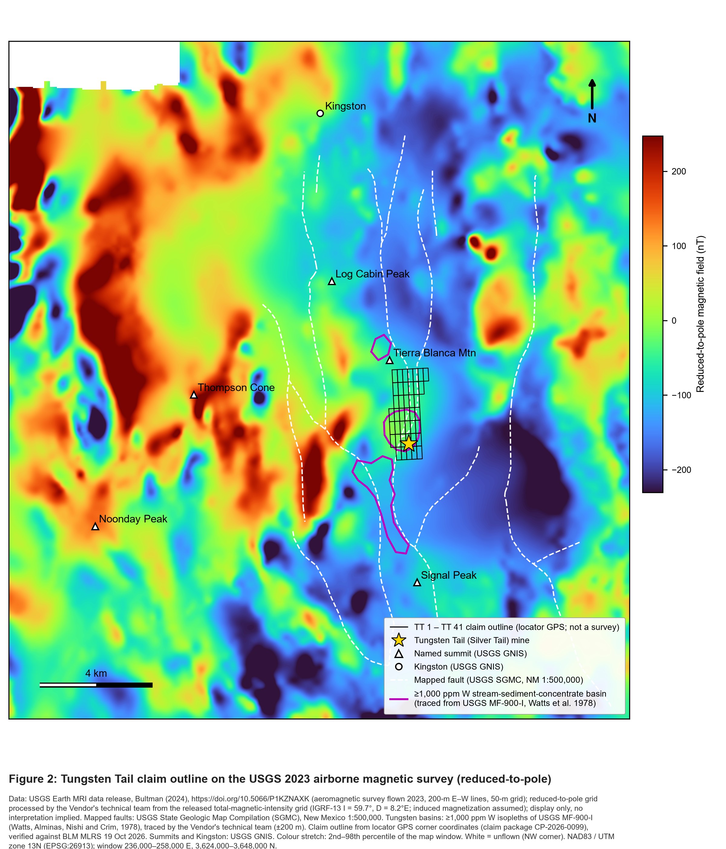
Figure 2: Tungsten Tail claim outline (black) on the USGS 2023 Earth MRI airborne magnetic survey (200-metre flight lines), shown as a reduced-to-pole grid processed by the Vendor's technical team from the publicly released total-magnetic-intensity grid (Bultman, 2024; https://doi.org/10.5066/P1KZNAXK). Magenta: tungsten-anomalous drainage basins traced from USGS MF-900-I (1978); white dashed: mapped faults (USGS State Geologic Map Compilation); star: Tungsten Tail mine. Display only; no interpretation of the magnetic data is presented.
To view an enhanced version of this graphic, please visit:
https://images.newsfilecorp.com/files/8310/320067_dbe67f24542d29f2_002full.jpg
Planned Work
Following the closing of the Transaction, Gordon Mining intends to carry out a first-phase exploration program designed to bring the Project to drill-ready status:
Surface work from the Tungsten Tail mine to the Jayhawk workings: geological mapping, ultraviolet-lamp scheelite mapping, channel sampling of the accessible historical workings, and rock and soil geochemistry along the Fusselman-Percha contact and the Pierce Canyon fault corridor.
Ground geophysics over the fault corridor: a detailed ground magnetic survey to follow up the 2023 USGS airborne data, followed by an induced polarization/resistivity (IP) or controlled-source audio-frequency magnetotelluric (CSAMT) survey to test for chargeable or conductive zones at depth.
Drill permitting: preparation and submission of drill-permit applications to the U.S. Forest Service and the State of New Mexico for a first drill program intended to test the down-dip extension of the historical mineralized zone beneath the workings.
The results of this work will be used to prioritize and refine drill targets and to support the drill-permitting process. Specific drill targets have not yet been defined.
Terms of the Transaction
Under the Agreement, the Company has agreed to acquire
The Vendor will retain a
Historical Data Cautionary Statement
The production figures, sample results, grades and government commentary in this news release are historical in nature. They are drawn from publications and mineral property files of the USBM, the USGS and the New Mexico Bureau of Geology and Mineral Resources (see References and Notes), were prepared before NI 43-101 came into effect, and do not comply with it. A Qualified Person has not verified the historical information or done sufficient work to classify any of it as a current mineral resource or mineral reserve, and the Company is not treating it as such. No mineral resource or mineral reserve has been estimated for the Project. There is no assurance that further exploration will reproduce the historical results. Historical selected and grab samples are selective by nature and are not representative of mineralization on the Project; heavy-mineral concentrate values are gravity-enriched and are not rock grades; and historical government interpretations quoted in this news release are the opinions of their authors at the time of publication and have not been verified by a Qualified Person. The bases for the production and grade statements in this news release are set out in notes 5 and 13 of the References and Notes.
The 2023 airborne magnetic and radiometric survey referenced in this news release was flown and published by the USGS as a regional public dataset. Neither the Company nor its Qualified Person has completed an interpretation of these data, and this news release does not present any interpretation of them. Airborne geophysical data do not identify mineralization directly, and no exploration target on the Project has been tested by drilling. References to the Company's exploration model, exploration targets and planned work are forward-looking.
References and Notes
1. Hedlund, D.C., 1977. Mineral resources map of the Hillsboro and San Lorenzo Quadrangle, Sierra and Grant Counties, New Mexico. U.S. Geological Survey Miscellaneous Field Studies Map MF-900-B, lode No. 74.
2. U.S. Geological Survey, 2025. Final 2025 List of Critical Minerals. Federal Register, v. 90, no. 214, pp. 50494-50497 (November 7, 2025). Tungsten was also included on the 2022 Final List of Critical Minerals (87 FR 10381, February 24, 2022).
3. Hedlund, D.C., 1979. Background information to accompany folio of geologic, mineral resource, geochemical, aeromagnetic, and gravity maps of the Hillsboro and San Lorenzo quadrangles, Sierra and Grant Counties, New Mexico. U.S. Geological Survey Circular 808, p. 8.
4. Dale, V.B., and McKinney, W.A., 1959. Tungsten Deposits of New Mexico. U.S. Bureau of Mines Report of Investigations 5517, pp. 65-68.
5. Grade basis. RI 5517 (pp. 66-67) reports the 1942 shipment grade of approximately
6. Watts, K.C., Alminas, H.V., Nishi, J.M., and Crim, W.C., 1978. Map showing anomalous tungsten and gold distribution in stream sediment concentrates, Hillsboro and San Lorenzo quadrangles exclusive of the Black Range Primitive Area, Sierra and Grant Counties, New Mexico. U.S. Geological Survey Miscellaneous Field Studies Map MF-900-I, scale 1:48,000.
7. Watts, K.C., Alminas, H.V., Nishi, J.M., and Crim, W.C., 1978. Map showing anomalous lead distribution in stream sediment concentrates, Hillsboro and San Lorenzo quadrangles, exclusive of the Black Range Primitive Area, Sierra and Grant Counties, New Mexico. U.S. Geological Survey Miscellaneous Field Studies Map MF-900-J, scale 1:48,000 (companion sheet to MF-900-I; source of the "good exploration target for deposits at depth" quotation).
8. Bultman, M.W., 2024, Aeromagnetic and aeroradiometric data acquired over parts of Grant, Hidalgo, Luna, Sierra, and Socorro Counties, New Mexico: U.S. Geological Survey data release, https://doi.org/10.5066/P1KZNAXK. Survey flown in 2023 at 200-metre flight-line spacing.
9. Hedlund, D.C., 1985. Economic geology of some selected mines in the Hillsboro and San Lorenzo quadrangles, Grant and Sierra Counties, New Mexico. U.S. Geological Survey Open-File Report 85-456, pp. 24-27, 39.
10. Claim-tenure history per U.S. Bureau of Land Management mining-claim records (closed claims, T17S R8W, Sierra County, New Mexico: Homestake Mining Co., 1980-1987; Canyon Resources Corp., 1981-1987; Santa Fe Pacific Mining Inc. and Phelps Dodge Corp., 1982-1989; Phelps Dodge Mining, 1989; Oryx Resources LLC, 2011-2015), as compiled in a land-status report dated July 8, 2026; Canyon Resources Corporation, Prospectus, 1985, p. 26 (excerpt preserved in New Mexico Bureau of Geology and Mineral Resources Mineral Property File 6803).
11. Lovering, T.G., and Heyl, A.V., 1989. Mineral belts in western Sierra County, New Mexico, suggested by mining districts, geology, and geochemical anomalies. U.S. Geological Survey Bulletin 1876, p. 20.
12. U.S. Bureau of Mines Mineral Property File 6671: Silver Tungsten (Silver Tail) property examination, V.B. Dale, September 14, 1957; Review of Examination, W.R. Storms, October 8, 1957.
13. Production tonnage. USGS Circular 808 (p. 8) records aggregate production from the Silver Tail (Tungsten Tail) group of mines of approximately 55 short tons of scheelite-bearing mineralization averaging 3
14. Siems, D.F., Alminas, H.V., and Watts, K.C., 1981. Analyses of the magnetic and nonmagnetic fractions of pan concentrates from the Hillsboro 15-minute quadrangle, southwestern New Mexico. U.S. Geological Survey Open-File Report 81-1090 (heavy-mineral concentrate analyses; sample 72HB839N).
Qualified Person
The scientific and technical information contained in this news release has been reviewed and approved by Nicholas Rodway, P.Geo. (EGBC No. 46541) (Permit to Practice No. 1000359), an independent consultant to the Company, who is a Qualified Person as defined by NI 43-101. The Qualified Person's review was limited to the technical disclosure contained in this news release. The historical information in this news release is derived from publications and mineral property files of the USBM, the USGS and the New Mexico Bureau of Geology and Mineral Resources, which the Company believes to be reliable but has not independently verified. No exploration or verification work has been completed by the Company on the Project to date. The Qualified Person has not visited the Project and has not verified the historical data disclosed in this news release.
Resignation of Keith Anderson
Keith Anderson has resigned as President of the Company. Ryan Connacher, Chief Executive Officer and a director, has been appointed President. The Company thanks Mr. Anderson for his contributions and wishes him well.
About Gordon Mining Group Inc.
Gordon Mining Group Inc. (CSE: GORD) (OTCQB: GSPFD) (FSE: L5Y) (formerly Golden Spike Resources Corp.) is a Canadian mineral exploration company focused on identifying, acquiring and unlocking value in mineral opportunities in Canada and other low-risk jurisdictions. The Company currently holds a
Contact Information
Ryan Connacher, President and Chief Executive Officer
+1 (647) 987-7458
Neither the Canadian Securities Exchange nor its Regulation Services Provider (as that term is defined in the policies of the Canadian Securities Exchange) accepts responsibility for the adequacy or accuracy of this news release.
Forward-Looking Statements
Certain statements made and information contained herein constitute "forward-looking information" within the meaning of applicable Canadian securities legislation, including statements regarding the completion of the Transaction and the timing thereof, the satisfaction of closing conditions including acceptance by the Canadian Securities Exchange, the Company's exploration intentions and planned surface work, interpretation of geophysical data, ground geophysics, drill permitting and drilling, the timing and results of the planned work program, the receipt of drill permits from the U.S. Forest Service and other authorities, the potential achievement of milestones under the Agreement, the Company's exploration model for the Project, and statements regarding the prospectivity of the Project, including the Company's reading of historical government geological, geochemical and geophysical data. Forward-looking information is often identified by words such as "intends," "plans," "expects," "anticipates," "targets," "potential" and similar expressions, and is based on assumptions management considers reasonable, including that the Transaction will close, that permits will be obtained on acceptable terms and timelines, and that exploration results will support further work. Forward-looking information is subject to known and unknown risks and uncertainties that may cause actual results to differ materially, including the risk that the Transaction does not close on the terms described or at all; the risk that the Canadian Securities Exchange does not accept the Transaction; risks relating to the validity of and title to unpatented mining claims, including the recording of the transfer of the claims to TT Minerals with the BLM; risks relating to permitting on U.S. Forest Service lands, including the timing and conditions of any plan of operations or state exploration permit; the risk that historical information proves to be inaccurate or that exploration does not reproduce historical results; risks associated with exploration activity generally, equipment limitations and availability, commodity price volatility, financing, and other risks of which the Company may not currently be aware. Accordingly, readers are advised not to place undue reliance on forward-looking information. Except as required under applicable securities legislation, the Company undertakes no obligation to publicly update or revise forward-looking information, whether as a result of new information, future events or otherwise.
To view the source version of this press release, please visit https://www.newsfilecorp.com/release/320067
FAQ
AI-generated questions and answers. How Rhea-AI works. Not financial advice.
What is Gordon Mining acquiring in the Tungsten Tail transaction?
Gordon Mining agreed to acquire 100% of the membership interests of TT Minerals from Lamina Minerals, an arm's-length party. TT Minerals holds the Tungsten Tail Project in Sierra County, New Mexico, comprising 41 contiguous unpatented lode claims covering approximately 847 acres.
What will Gordon Mining pay at closing for Tungsten Tail?
Gordon Mining will pay C$125,000 in cash and issue 1,500,000 common shares at closing. Additional consideration depends on permitting, drilling and resource milestones. The vendor will also retain a 2.0% net smelter returns royalty on the Project and the defined Area of Interest.
What triggers Gordon Mining's C$500,000 Tungsten Tail resource milestone payment?
The payment requires completion and filing on SEDAR+ of an NI 43-101 or JORC technical report disclosing not less than 5,000,000 tonnes of measured, indicated or inferred resources, in aggregate, averaging at least 0.7% WO₃ equivalent on the Project or Area of Interest. Gordon may pay cash or shares. These contractual thresholds are not resource estimates.
Where can drilling qualify for Gordon Mining's Tungsten Tail milestones?
Qualifying drilling can occur on the Project or within the Area of Interest, defined as within one mile of the claims' exterior boundaries. The first-phase drilling milestone requires at least 1,000 metres of core or reverse circulation drilling, measured as total metres drilled irrespective of assay results.