Myriad Uranium Doubles Land Position at Copper Mountain Uranium Project
Rhea-AI Summary
Myriad Uranium (OTCQB: MYRUF) doubled its land position at the Copper Mountain Uranium Project in Wyoming, increasing holdings from ~9,439 acres to ~18,351 acres to cover key district targets.
The expansion follows a December 2025 high-resolution radiometric and magnetic survey that identified new radiometric anomalies east of a north-south structural corridor; Myriad now controls ~62% of the Bendix Assessment Area and ~80% of the Control Area.
Positive
- Land position increased from approximately 9,439 to 18,351 acres
- Controls ~62% of Bendix Assessment Area
- Controls ~80% of Bendix Control Area
- High-resolution geophysics identified large new anomaly area east of known resources
Negative
- Bendix endowment figures are historical estimates, not NI 43-101 compliant
- Underlying original drill logs and assay data are predominantly unavailable
- Verification requires digitization, re-logging and additional drilling
News Market Reaction – MYRUF
In the Mar 10 session, MYRUF gained 12.91%, reflecting a significant positive market reaction.
Data tracked by StockTitan Argus on the day of publication.
AI-generated analysis. How Rhea-AI works. Not financial advice.
Vancouver, British Columbia--(Newsfile Corp. - March 10, 2026) - Myriad Uranium Corp. (CSE: M) (OTCQB: MYRUF) (FSE: C3Q) ("Myriad" or the "Company") is pleased to announce a significant expansion of its land position at the Copper Mountain Uranium Project in Wyoming, increasing total holdings from approximately 9,439 acres to approximately 18,351 acres. This acreage now covers all key areas and targets across the Copper Mountain district. See Figures 1 and 3 below.
The expanded staking program was guided by results from the Company's recent high-resolution radiometric and magnetic survey. Notably, the vast majority of radiometric anomaly points identified by the survey occur in previously untested ground east of the north-south structural corridor indicated. See Figure 2 below. In contrast, all known historic uranium resources and nearly all previously identified targets at Copper Mountain are located west of this corridor. The southern areas have been added because of other highly positive characteristics.
To determine which areas to acquire, the Company integrated the new geophysical data with its existing geological dataset, including insights derived from the comprehensive studies of Copper Mountain completed by Bendix Field Engineering Corporation ("Bendix") for the U.S. Department of Energy in 1982. The Bendix study estimated uranium endowments at Copper Mountain of approximately 655 Mlbs eU₃O₈ to a depth of 600 feet within a broader "Assessment Area," and 245 Mlbs eU₃O₈ to a depth of 600 feet within a more focused "Control Area."
Following the staking update announced here, Myriad now controls approximately
Myriad's CEO, Thomas Lamb, commented: "Our recent geophysics identified the signatures of known uranium resources at Copper Mountain and illuminated an entirely new very large area to the east of known resources with a corresponding signature. See Figure 2 below and refer to our recent press release here. We quickly acquired this new large area and other areas suggested by the geophysics and our other data. Confidence is increasing that we now have one of the largest uranium projects in the United States. Based on results of our own initial drill program, we already have strong confidence in the core deposits and historic resources delineated by Union Pacific in the 1970's. As uranium prices rise, a progressively larger share of our endowment will transition into economic viability, offering strong leverage to the steadily increasing price of uranium."
The Bendix endowment figures are historical estimates and are not current mineral resource estimates prepared in accordance with NI 43-101 standards. See "Historical Estimates" below for further information.
The focus will now shift to verification of anomalies identified through the interpretation of the high-resolution geophysical surveys completed in December 2025 (reported here), followed by exploration drilling.
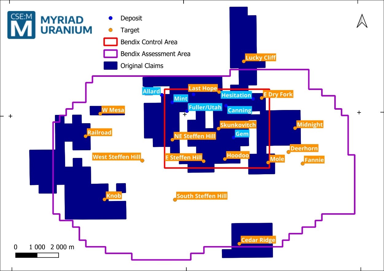
Figure 1: Original claim areas prior to the current staking round.
To view an enhanced version of this graphic, please visit:
https://images.newsfilecorp.com/files/6301/287916_edd2a4e214bf1ae1_002full.jpg
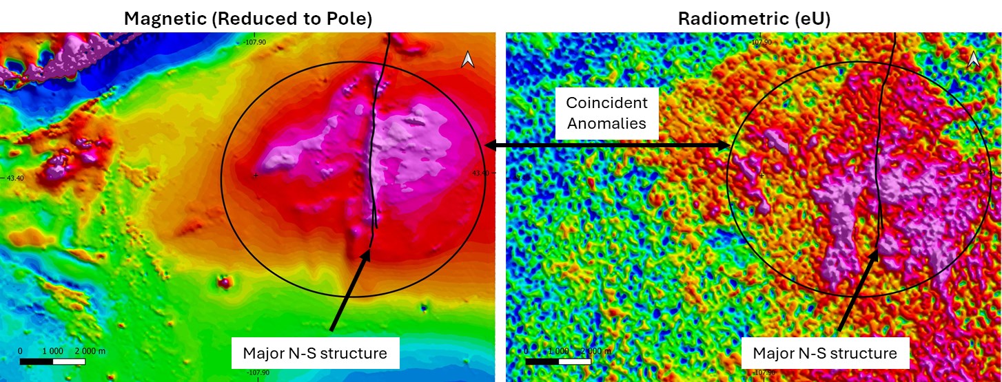
Figure 2: Results of the large scale high-resolution geophysical surveys at Copper Mountain.
To view an enhanced version of this graphic, please visit:
https://images.newsfilecorp.com/files/6301/287916_edd2a4e214bf1ae1_003full.jpg
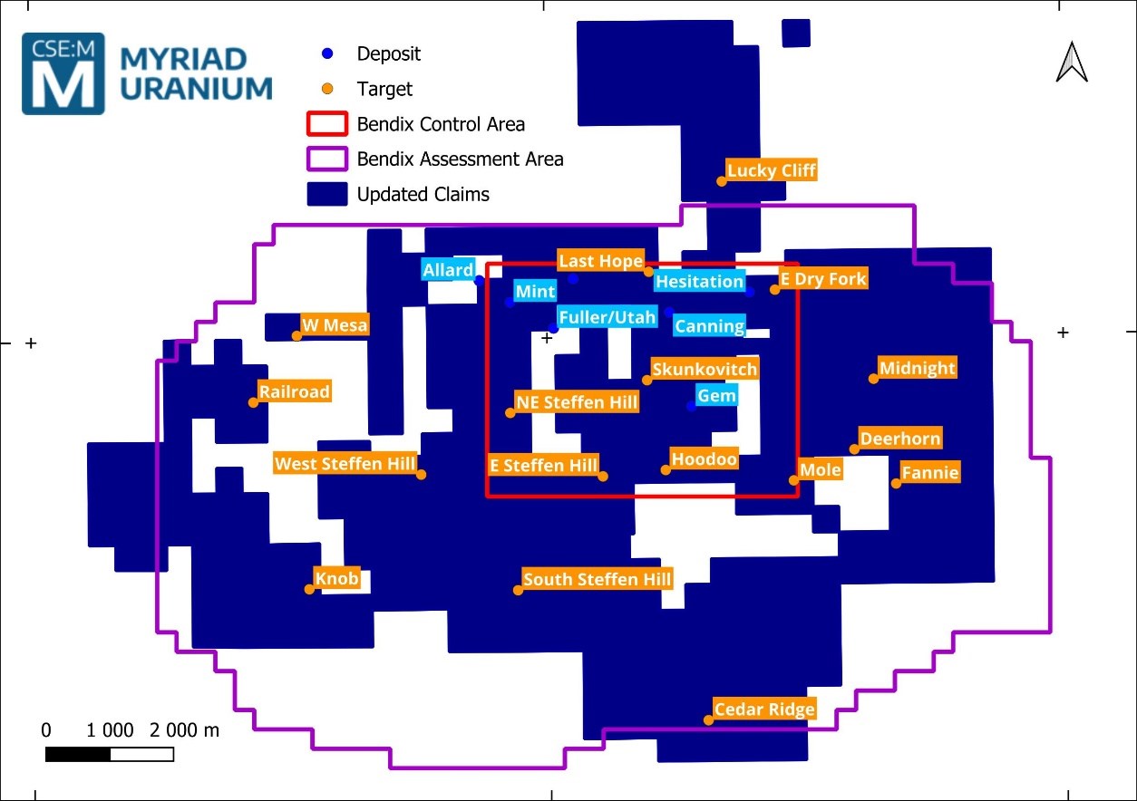
Figure 3: Updated claim areas.
To view an enhanced version of this graphic, please visit:
https://images.newsfilecorp.com/files/6301/287916_edd2a4e214bf1ae1_004full.jpg
Historical Estimates
While Myriad Uranium has determined that the historical estimates described in this news release are relevant to the Copper Mountain Project Area and are reasonably reliable given the authors and circumstances of their preparation, and are suitable for public disclosure, readers are cautioned to not place undue reliance on these historical estimates as an indicator of current mineral resources or mineral reserves at the Project Area. A qualified person (as defined under NI 43-101) has not done sufficient work to classify any of the historical estimates as current mineral resources or mineral reserves, and Myriad Uranium is not treating the historical estimates as a current mineral resource or mineral reserve. Also, while the Copper Mountain Project Area contains all or most of each deposit referred to, some of the resources referred to may be located outside the current Copper Mountain Project Area. Furthermore, the estimates are decades old and based on drilling data for which the logs are, as of yet, predominantly unavailable. The historical resource estimates, therefore, should not be unduly relied upon.
Inherent limitations of the historical estimates include that the nature of mineralisation (fracture hosted) makes estimation from drill data less reliable than other deposit types (e.g. those that are thick and uniform). From Myriad Uranium's viewpoint, limitations include that the Company has not been able to verify the data itself and that the estimate may be optimistic relative to subsequent work which applied a "delayed fission neutron" (DFN) factor to calculate grades. On the other hand, DFN is controversial, in that the approach is viewed by some experts as too conservative. Nevertheless, it was applied in later resource estimations by Union Pacific relating to Copper Mountain.
To verify the historical estimates and potentially re-state them as current resources, a program of digitization of available data would be required. This must be followed by re-logging and/or re-drilling to generate new data to the extent necessary that it is comparable with the original data, or new data that can be used to establish the correlation and continuity of geology and grades between boreholes with sufficient confidence to estimate mineral resources.
Qualified Person
The scientific or technical information in this news release respecting the Company's Copper Mountain Project has been reviewed and approved by George van der Walt, MSc., Pr.Sci.Nat., FGSSA, Myriad's consulting geologist and a Qualified Person as defined in National Instrument 43-101 - Standards of Disclosure for Mineral Projects. While the content of the reports is considered to be relevant and reliable, the underlying data, such as original drill logs, sampling, analytical and test data certificates, quality assurance and quality control, is not available for verification. Further work, such as drilling and sampling, will be required to verify or create supplementary information to support the underlying assumptions and conclusions.
About Myriad Uranium Corp.
Myriad Uranium Corp. holds a
A news release detailing a comprehensive assessment of Copper Mountain's uranium endowment by Bendix Engineering for the US Department of Energy published in 1982 can be viewed here.
For further information, please refer to Myriad's disclosure record on SEDAR+ (www.sedarplus.ca), contact Myriad by telephone at +1.604.418.2877, or refer to Myriad's website at www.myriaduranium.com.
Myriad Contacts:
Thomas Lamb
President and CEO
tlamb@myriaduranium.com
Forward-Looking Statements
This news release contains "forward-looking information" that is based on the Company's current expectations, estimates, forecasts and projections. This forward-looking information includes, among other things, the Company's business, plans, outlook and business strategy. The words "may", "would", "could", "should", "will", "likely", "expect," "anticipate," "intend", "estimate", "plan", "forecast", "project" and "believe" or other similar words and phrases are intended to identify forward-looking information. The reader is cautioned that assumptions used in the preparation of any forward-looking information may prove to be incorrect, including with respect to the Company's business plans respecting the exploration and development of the Company's mineral properties, the proposed work program on the Company's mineral properties and the potential and economic viability of the Company's mineral properties. Forward-looking information is subject to known and unknown risks, uncertainties and other factors that may cause the Company's actual results, level of activity, performance or achievements to be materially different from those expressed or implied by such forward-looking information. Such factors include, but are not limited to: changes in economic conditions or financial markets; increases in costs; litigation; legislative, environmental and other judicial, regulatory, political and competitive developments; and technological or operational difficulties. This list is not exhaustive of the factors that may affect our forward-looking information. These and other factors should be considered carefully, and readers should not place undue reliance on such forward-looking information. The Company does not intend, and expressly disclaims any intention or obligation to, update or revise any forward-looking information whether as a result of new information, future events or otherwise, except as required by applicable law.
The CSE has not reviewed, approved or disapproved the contents of this news release.
![]()
To view the source version of this press release, please visit https://www.newsfilecorp.com/release/287916