Solis Minerals (SLMFF) has initiated diamond drilling at its flagship Ilo Este copper-gold project in Peru. The company plans to execute a 5,000-metre drilling program targeting areas of known copper-gold mineralization and new target zones identified through recent geophysical and geological work.
The project is strategically located in a world-class mining district near major copper mines operated by Southern Copper, Teck, and Anglo American. Historical drilling results have shown promising mineralization, including intersections of 158 metres @ 0.20% copper and 0.16 g/t gold from surface, and 291 metres @ 0.21 g/t gold from 102 metres.
Loading...
Loading translation...
Positive
Strategic location in world-class mining district near major copper producers
Historical drilling showed significant mineralization with 158m @ 0.20% copper and 0.16 g/t gold
100% ownership of the Ilo Este project
Additional untested targets identified through recent technical studies
Negative
Early-stage exploration project with no defined resource yet
Results from new drilling program not yet available
News Market Reaction – SLMFF
-94.36%
-94.36%Session move
In the trading session that priced this news, SLMFF declined 94.36%, reflecting a significant negative market reaction.
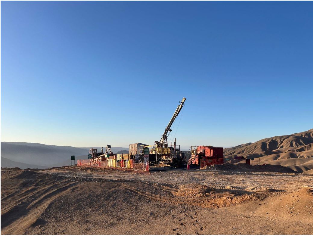
Drilling has commenced at Solis Minerals' flagship Ilo Este copper-gold project in Peru.
Initial program to comprise approximately 5,000 metres of diamond drilling.
Program designed to test areas of known copper-gold mineralisation and evaluate new target zones identified through recent geophysical and geological work.
Ilo Este is located in a world-class mining district, near several major copper mines and excellent infrastructure.
West Leederville, Western Australia--(Newsfile Corp. - August 11, 2025) - Solis Minerals Limited (ASX: SLM) ("Solis Minerals" or the "Company") is pleased to announce that diamond drilling has commenced at its flagship project, the Ilo Este copper-gold Project in southern Peru (Figure 1). Ilo Este is 100%-owned by Solis Minerals.
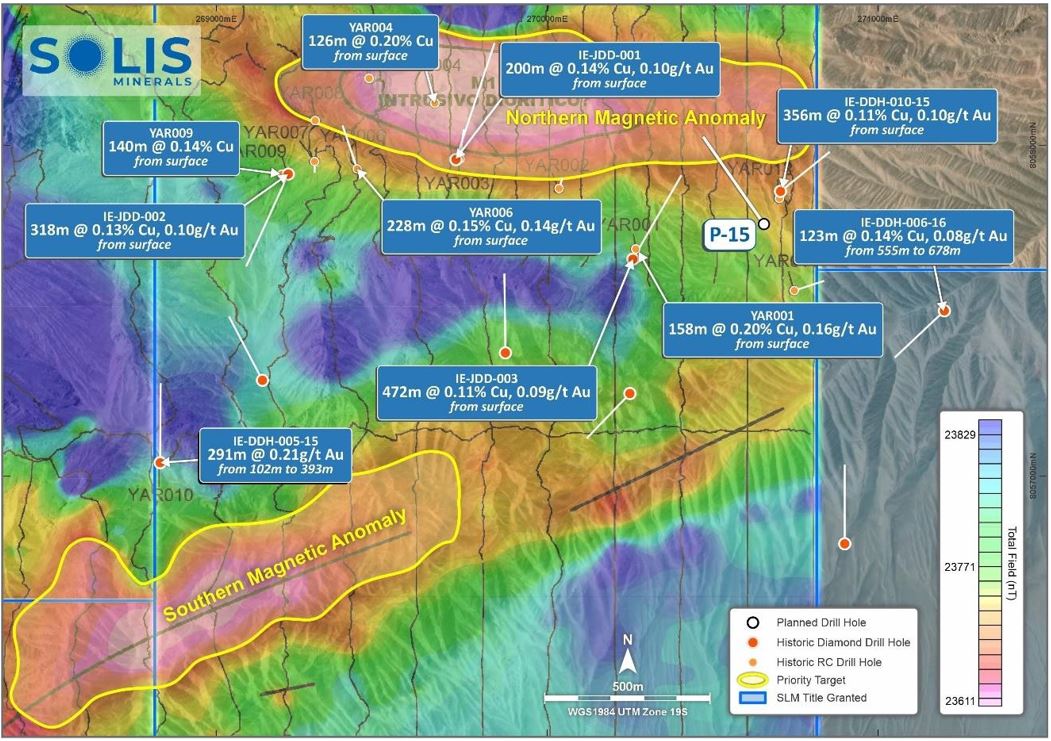
The initial diamond drilling program will comprise approximately 5,000 metres and is designed to follow up on historical intercepts of broad porphyry-style copper-gold mineralisation1. Drilling has commenced in the north-east of the Ilo Este project area targeting a northern magnetic anomaly before mobilising to the southern magnetic anomaly (Figure 2). The program will also test newly defined targets generated through recent mapping, surface sampling and reinterpretation of historical geophysics2.
The Ilo Este project is located in a prolific copper district that hosts several major international copper mining companies in production or with advanced projects including Southern Copper, Teck and Anglo American. The Company's targets (Figure 2) are analogous to AusQuest Limited's (ASX: AQD) Cangallo exploration prospect in southern Peru, where wide zones of copper mineralisation have been discovered3.
Chief Executive Officer, Mitch Thomas, commented:
"We are very excited to commence drilling at Ilo Este. This project represents a compelling exploration opportunity in a highly prospective geological setting.
The existence of historical drilling, including YAR0014 with an intersection of 158 metres @ 0.20% copper and 0.16 g/t gold from surface5 and IE-DDH-005-15 with an intersection of 291 metres @ 0.21 g/t gold from 102 metres, highlight the attractive prospectivity of the Ilo Este project. Technical studies completed over the past 24 months have identified additional untested attractive targets.
Our team has worked diligently to refine a five thousand metre work programme and secure all necessary approvals, and we look forward to updating shareholders as results become available."
1 Refer to ASX: SLM announcement from 22 April 2025 Corporate Presentation. Refer to ASX: LRS announcement from 29 April 2014 Latin Defines Significant Copper-Gold Porphyry System at Ilo Este With Multiple Drill Targets. 2 Refer to ASX: SLM announcement from 13 December 2023 Anomaly confirms drill target zone during IP study at Ilo Este. 3 Refer to ASX: AQD announcement from 21 July 2025 Cangallo porphyry copper discovery grows. 4 Refer to the Note at end of this release. 5 Please refer to the note commencing on page four in relation to non-JORC compliant historical exploration results.
Figure 2: Ilo Este, Peru concession area showing location of drill hole one (P-15) targeting the northern magnetic anomaly labelled. Please refer to the Note on page four in relation to non-JORC compliant historical exploration results.
Solis Minerals is an emerging exploration company, focused on unlocking the potential of its South American copper portfolio. The Company is building a significant copper portfolio around its core tenements of Ilo Este and Ilo Norte and elsewhere in the Southern Coastal Belt of Peru.
The Company is led by a highly-credentialled and proven team with excellent experience across the mining lifecycle in South America. Solis Minerals is actively considering a range of copper opportunities. South America is a key player in the global export market for copper and Solis Minerals, under its leadership team, is strategically positioned to capitalise on growth the opportunities within this mineral-rich region.
Forward-Looking Statements
This news release contains certain forward-looking statements that relate to future events or performance and reflect management's current expectations and assumptions. Such forward- looking statements reflect management's current beliefs and are based on assumptions made and information currently available to the Company. Readers are cautioned that these forward-looking statements are neither promises nor guarantees and are subject to risks and uncertainties that may cause future results to differ materially from those expected, including, but not limited to, market conditions, availability of financing, actual results of the Company's exploration and other activities, environmental risks, future metal prices, operating risks, accidents, labour issues, delays in obtaining governmental approvals and permits, and other risks in the mining industry. All the forward-looking statements made in this news release are qualified by these cautionary statements and those in our continuous disclosure filings. These forward-looking statements are made as of the date hereof, and the Company does not assume any obligation to update or revise them to reflect new events or circumstances save as required by applicable law.
Qualified Person Statement
The technical information in this news release was reviewed by Michael Parker, a Fellow of the Australian institute of Mining and Metallurgy (AusIMM), a qualified person as defined by National Instrument 43-101 (NI 43-101). Michael Parker is Technical Director of the Company.
Competent Person Statement
The information in this ASX release concerning Geological Information and Exploration Results is based on and fairly represents information compiled by Mr Michael Parker, a Competent Person who is a Fellow of the Australasian Institute of Mining and Metallurgy. Mr Parker is a contractor to Solis Minerals Ltd. and has sufficient experience which is relevant to the style of mineralisation and types of deposit under consideration and to the exploration activities undertaken to qualify as a Competent Person as defined in the 2012 Edition of the "Australian Code for Reporting of Mineral Resources and Ore Reserves". Mr Parker consents to the inclusion in this report of the matters based on information in the form and context in which it appears. Mr Parker has provided his prior written consent regarding the form and context in which the Geological Information and Exploration Results and supporting information are presented in this Announcement.
Disclaimer
In relying on the above mentioned ASX announcement and pursuant to ASX Listing Rule 5.23.2, the Company confirms that it is not aware of any new information or data that materially affects the information included in the above-mentioned announcement.
Note:
Some of the historical Exploration Results above have been previously reported by Latin Resources Limited as noted in the footnotes. Due to historical data recently being sourced from digital archives, additional drillhole data from Rio Tinto Limited ("Rio Tinto") has been presented that has not been previously reported.
As noted, some historic exploration was undertaken and reported in the 2000's. Specifically, drilling was completed by Rio Tinto Exploration in the year 2000, and Latin Resources and its JV partner Zahena between 2014 and 2016. No results from the Rio Tinto drilling have been located in the public domain.
Solis is unable to determine the accuracy of all drilling results from Rio Tinto, however Solis is of the opinion that drilling undertaken in 2000 should be reliable under current standards. Rio Tinto completed 12 RC holes for a total of 2,128 metres of varying depths. All RC collars have been located and verified by Solis personnel in the field, including the QP.
Solis has not identified any additional exploration results or data relevant to understanding these Exploration Results.
Solis Minerals intends to complete several diamond drillholes in proximity to prior exploration by Rio Tinto to, where possible, validate the historic results noted above. Detailed hole location surveys will be completed for new holes undertaken by Solis and will include historical collars.. All new activities undertaken by Solis will be reported in accordance with the JORC Code 2012.
Solis intends to undertake the proposed exploration work in the second half of 2025.
Solis cautions that these reported Exploration Results are historical estimates and:
Have not been reported in accordance with the JORC Code 2012;
A Competent Person has not done sufficient work to disclose the Exploration Results in accordance with the JORC Code 2012;
It is possible that following further evaluation and/or exploration work that the Exploration Results will be able to be reported as mineral resources or ore reserves under the JORC Code 2012;
Nothing has come to the attention of Solis that causes it to question the accuracy or reliability of former Exploration Results; but
Solis has not independently validated former Exploration Results and therefore is not to be regarded as reporting, adopting or endorsing those results.
Refer to Appendix 1 for more detailed information on the Historical Exploration Results.
APPENDIX 1 - HISTORICAL EXPLORATION RESULTS
There has been a relatively small amount of exploration work before Peruvian Latin Resources Ltd obtained for the concessions. Rio Tinto undertook mapping sampling and a small amount of reverse circulation drilling at Ilo Este in 2000. The centre point of the Ilo Este Project is located at 268,080 mE and 8,059,075 mN in the southern Zone 19S of PSAD56 UTM system.
The Ilo Este project has had three drilling campaigns completed. One 2,128 metres reverse circulation program in 2000 by Rio Tinto, one 2,073 metres diamond drilling program between 2014 - 2015 and a final diamond drilling program of 5,322 metres in 2015 - 2016 both completed by Latin Resources Limited and its JV partner Zahena. Latin Resources drilling has been referenced in the current and previous news releases.
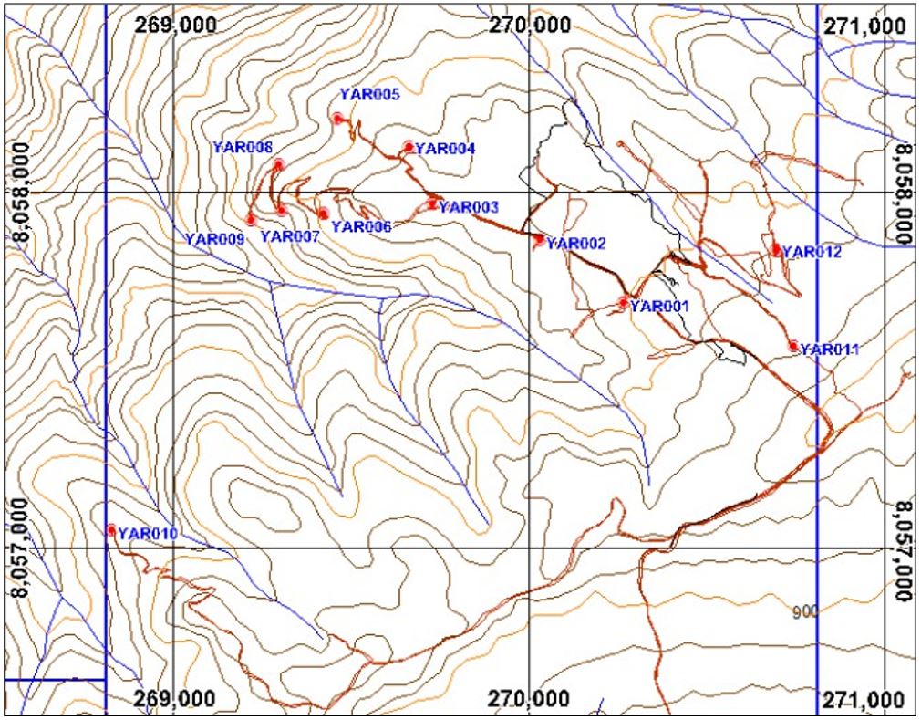
The Rio Tinto results presented in Figure 2 (YAR001, YAR004, YAR006 and YAR009) have been derived from graphs and should be regarded as indicative. Drill platforms and collars, shown in Figure 3, have been independently surveyed during the 2014 ground magnetometry program and their existence confirmed by the Solis QP in the field. Hole localities from Rio Tinto are presented in Table 1 and significant indicative mineralisation intersections are presented in Table 2.
Table 1: Rio Tinto RC drillhole data. Material results are presented in Figure 2
HOLE ID
EAST_WGS84
NORTH_WGS84
RL
Azimuth
Dip
DEPTH
Hole Type
YAR001
270268
8057686
896
200
-70
158
RC
YAR002
270037
8057869
747
25
-80
204
RC
YAR003
269734
8057960
897
10
-60
198
RC
YAR004
269661
8058128
892
340
-70
164
RC
YAR005
269465
8058200
801
285
-70
168
RC
YAR006
269428
8057929
834
340
-60
228
RC
YAR007
269299
8057952
777
175
-80
216
RC
YAR008
269302
8058073
770
0
-90
78
RC
YAR009
269218
8057913
914
240
-75
198
RC
YAR010
268828
8057040
884
180
-65
198
RC
YAR011
270747
8057561
929
60
-60
194
RC
YAR012
270702
9057840
904
230
-60
114
RC
Table 2: Indicative Au and Cu composite results from YAR RC holes (significant intersections). Material results are presented in Figure 2
RC HOLE
FROM (m)
TO (m)
INTERESECTION (m)
Au g/t
Cu %
YAR001
0
158
158
0.16
0.20
YAR002
60
84
24
0.12
0.10
94
196
102
0.24
0.18
YAR003
30
198
168
0.10
0.16
YAR004
0
126
126
Illegible
0.20
YAR005
30
54
24
0.13
0.14
YAR006
0
228
228
0.14
0.15
YAR007
8
80
72
Illegible
0.10
YAR008
50
74
24
Illegible
0.10
YAR009
0
140
140
Illegible
0.14
YAR010
0
198
198
Illegible
Illegible
YAR011
58
90
32
Illegible
0.11
YAR012
0
18
18
Illegible
0.10
Figure 3: Location of the Rio Tinto RC holes from the 2000 program
Nature and quality of sampling (e.g. cut channels, random chips, or specific specialised industry standard measurement tools appropriate to the minerals under investigation, such as down hole gamma sondes, or handheld XRF instruments, etc). These examples should not be taken as limiting the broad meaning of sampling.
Include reference to measures taken to ensure sample representativity and the appropriate calibration of any measurement tools or systems used.
Aspects of the determination of mineralisation that are Material to the Public Report. In cases where 'industry standard' work has been done this would be relatively simple (e.g. 'reverse circulation drilling was used to obtain 1 m samples from which 3 kg was pulverised to produce a30 g charge for fire assay'). In other cases more explanation may be required, such as where there is coarse gold that has inherent sampling problems. Unusual commodities or mineralisation types (e.g. submarine nodules) may warrant disclosure of detailed information.
Wire-line diamond drilling is being used to obtain core samples for sampling and assaying purposes.
Zones with visible economic minerals or otherwise considered to be of importance will be sampled at 1m core intervals.
Zones considered to be background to mineralisation will be sampled at 2m core intervals.
Cores will be sawn and half cores sent to laboratory for crushing and splitting. A 250g pulp will be prepared for analysis. Coarse rejects will be returned to the company for possible further compositing and analysis etc.
Appropriate standard reference materials and blanks will be inserted into the sample line, as well as duplicates consisting of quarter cores etc.
Drilling techniques
Drill type (e.g. core, reverse circulation, open-hole hammer, rotary air blast, auger, Bangka, sonic, etc) and details (e.g. core diameter, triple or standard tube, depth of diamond tails, face- sampling bit or other type, whether core is oriented and if so, by what method, etc).
Wire-line diamond drilling. HQ diameter core from surface to initiate.
Non-orientated core (orientation not considered necessary for type of mineralisation expected).
Drillsample recovery
Method of recording and assessing core and chip sample recoveries and results assessed.
Measures taken to maximise sample recovery and ensure representative nature of the samples.
Whether a relationship exists between sample recovery and grade and whether sample bias may have occurred due to preferential loss/gain of fine/coarse material.
Coring advance and depths will be recorded and verified against physical core.
Recovery will be maximised by appropriate drill methods. (frequency of core pulls, additives etc.).
Nature of rocks has not resulted in any sample bias due to grain-size aspects.
Logging
Whether core and chip samples have been geologically and geotechnically logged to a level of detail to support appropriate Mineral Resource estimation, mining studies and metallurgical studies.
Whether logging is qualitative or quantitative in nature. Core (or costean, channel, etc) photography.
The total length and percentage of the relevant intersections logged.
Core samples will be subject to detailed geological logging and rock quality analysis (RQD) sufficient for Mineral Resource estimation etc.
Logging to note presence of geology, alteration, and of economic minerals of interest (if visible). Core photographed.
Sub-sampling techniques and sample preparation
If core, whether cut or sawn and whether quarter, half or all core taken.
Ifnon-core,whetherriffled,tube sampled, rotary split, etc and whether sampled wet or dry.
For all sample types, the nature, quality and appropriateness of the sample preparation technique.
Quality control procedures adopted for all sub-sampling stages to maximise representativity of samples.
Measures taken to ensure that the sampling is representative of the in-situ material collected, including for instance results for field duplicate/second-half sampling.
Whether sample sizes are appropriate to the grain size of the material being sampled.
Core samples will be sawn. Half-core taken for analysis.
Crush to 70 % passing 2mm, riffle split off 250g, pulverise split to better than 85% passing 75 microns. Methods considered appropriate for type of mineralisation being tested. Equipment cleaned with compressed air between each sample and with clean rock between each batch.
Appropriate certified reference material and coarse blanks will be inserted. Each batch of 20 samples will have a quarter core duplicate inserted.
Sample size appropriate for type of visual mineralisation intersected.
Criteria
JORC Code explanation
Commentary
Quality of assay data and laboratory tests
The nature, quality and appropriateness of the assaying and laboratory procedures used and whether the technique is considered partial or total.
For geophysical tools, spectrometres, handheld XRF instruments, etc, the parametres used in determining the analysis including instrument make and model, reading times, calibrations factors applied and their derivation, etc.
Nature of quality control procedures adopted (e.g. standards, blanks, duplicates, external laboratory checks) and whether acceptable levels of accuracy (i.e. lack of bias) and precision have been established.
All rock chips will be assayed by ALS in Lima. Methods intended to use:
Preparation PREP31
Analysis Au-AA23 and ME-ICP61
Cu OG-62 for overlimit Cu >1%
Pb OG-62 for overlimit Pb >1%
Zn OG-62 for overlimit Zn >1%
Ag OG-62 for overlimit Ag >100ppm
OREAS standards, blanks, and field duplicates will be inserted at appropriate intervals.
Verification of Sampling and assaying
The verification of significant intersections by either independent or alternative company personnel.
The use of twinned holes.
Documentation of primary data, data entry procedures, data verification, data storage (physical and electronic) protocols.
Discuss any adjustment to assay data.
Intersections will be validated by two company geologists with sufficient experience.
Sampling and logging will be carried out in dedicated warehouse area.
Data is being documented and stored on company digital media to industry standards.
Location of data points
Accuracy and quality of surveys used to locate drill holes (collar and down-hole surveys), trenches, mine workings and other locations used in Mineral Resource estimation.
Specification of the grid system used.
Quality and adequacy of topographic control.
Hole collar and set out done using conventional GPS and compass methods. Holes will be picked up by qualified surveyor at end of drill campaign.
Hole will be down-hole surveyed.
Grid system used is industry standard in area: WGS84 19S.
Dataspacing and distribution
Data spacing for reporting of Exploration Results.
Whether the data spacing and distribution is sufficient to establish the degree of geological and grade continuity appropriate for the Mineral Resource and Ore Reserve estimation procedure(s) and classifications applied.
Whether sample compositing has been applied.
The drill campaign is investigating geophysical anomalies of several hundred metres size.
Initial drilling is focusing on core areas in the anomalies and may be followed up by smaller spaced grid drilling.
Samples will be composited to 2m length if no visible mineralisation. No compositing is envisaged between drillholes.
Orientation of data in relation to geological structure
Whether the orientation of sampling achieves unbiased sampling of possible structures and the extent to which this is known, considering the deposit type.
If the relationship between the drilling orientation and the orientation of key mineralised structures is considered to have introduced a sampling bias, this should be assessed and reported if material.
The drilling is designed to intersect geophysical anomalies at a high angle to local structures.
Given the initiation of first drill-hole, it is not considered necessary to draw sections at this juncture.
Criteria
JORC Code explanation
Commentary
Sample security
The measures taken to ensure sample security.
Samples will be received at the rig by authorised company personnel and will remain under the chain of custody of the company until the samples are physically delivered to ALS laboratories.
Auditsor reviews
The results of any audits or reviews of sampling techniques and data.
Standard sampling techniques employed with necessary oversight. No historical data.
Section 2 Reporting of Exploration Results (Criteria listed in the preceding section also apply to this section)
Criteria
JORC Code explanation
Commentary
Mineral tenementand landtenure status
Type, reference name/number, location and ownership including agreements or material issues with third parties such as joint ventures, partnerships, overriding royalties, native title interests, historical sites, wilderness or national park and environmental settings.
The security of the tenure held at the time of reporting along with any known impediments to obtaining a licence to operate in the area.
The Ilo Este project is located in three 100% owned exploration concessions of the company.
The current drilling is being carried out on state land..
Renewal payments for the tenements are due at the end of June annually. Tenements in good standing.
There are no known impediments to obtaining a licence to operate in the current drill area and all exploration permits have been granted.
Exploration done by other parties
Acknowledgmentandappraisalof exploration by other parties.
This release includes the incorporation into the company's exploration reporting of 12 RC holes drilled on the Yaral (Ilo Este) project in 2000 by Rio Tinto. This program had a total of 2128m and 1064 samples were collected at 2m intervals.
Despite the technical limitations listed below, the company considers that the data derived from this program is suitable for INDICATIVE commentary on previous exploration that may assist the company's current exploration programs. The results are non-JORC compliant and are not being considered as material due to their unverified nature.
The collar position of the holes is tabulated in Table 1 of this release.
The QP has verified the existing drillpads of this drilling from detailed satellite photography, and has visited every drillpad in the field. Evidence of drilling was found at each site although some drill markers have been disturbed by vehicular traffic.
The only assay data available for this drill program are assay strip logs that graphically display grades of Au (ppb), Cu (ppm), Fe (%), Mo (ppm), Zn (ppm), Ca (%), K (%), Na (%), and As (ppm).
There is no QA/QC verification, nor assay certificate database for this program. There are no coarse rejects available. Results are non-JORC compliant, unverified, and indicative.
Au and Cu values have been transposed into estimated, indicative values in a tabulated form and shown in Table 2. Down-hole intercept length, true width not known.
Due to colour issues on the strip logs some 586 Au samples were not visible to read.
All of hole YAR010 was not visible to read for Au and Cu due to colour issues (Au) and a missing scale bar (Cu).
Geology
Deposit type, geological setting and style of mineralisation.
The Ilo Este area is situated in an area of two intrusive belts of Jurassic and Cretaceous age - known locally as the Coastal Belt. Porphyry mineralisation (Cu/Au) has been observed and previously drilled at Ilo Este.
Drillhole Information
A summary of all information material to the understanding of the exploration results including a tabulation of the following information for all Material drill holes:
easting and northing of the drill hole collar
elevation or RL (Reduced Level - elevation above sea level in metres) of the drill hole collar
dip and azimuth of the hole
hole length
If the exclusion of this information is justified on the basis that the information is not Material and this exclusion does not detract from the understanding of the report, the Competent Person should clearly explain why this is the case.
The drillhole collar and data of current drilling is tabulated in the body of the release.
Drillhole section will be drawn subsequent to completion of second hole if feasible.
Criteria
JORC Code explanation
Commentary
Data aggregation methods
In reporting Exploration Results, weighting averaging techniques, maximum and/or minimum grade truncations (e.g. cutting of high grades) and cut-off grades are usually Material and should be stated.
Where aggregate intercepts incorporate short lengths of high-grade results and longer lengths of low-grade results, the procedure used for such aggregation should be stated and some typical examples of such aggregations should be shown in detail.
The assumptions used for any reporting of metal equivalent values should be clearly stated.
Intersections will be tabulated where appropriate after reception of results.
Relationship between mineralisation widthsand intercept lengths
These relationships are particularly important in the reporting of Exploration Results.
If the geometry of the mineralisation with respect to the drill hole angle is known, its nature should be reported.
If it is not known and only the down hole lengths are reported, there should be a clear statement to this effect (e.g. 'down hole length, true width not known').
No current data to hand as yet.
Historical (RC data) has no geology logs. Intercepts reported do not reflect true width (that is unknown).
Diagrams
Appropriate maps and sections (with scales) and tabulations of intercepts should be included for any significant discovery being reported These should include, but not be limited to a plan view of drill hole collar locations and appropriate sectional views.
Section will be provided after drilling of the second hole if practical.
Balanced reporting
Where comprehensive reporting of all Exploration Results is not practicable, representative reporting of both low and high grades and/or widths should be practiced avoiding misleading reporting of Exploration Results.
Will be applied to current drilling if appropriate.
Other substantive exploration data
Other exploration data, if meaningful and material, should be reported including (but not limited to): geological observations; geophysical survey results; geochemical survey results; bulk samples - size and method of treatment; metallurgical test results; bulk density, groundwater, geotechnical and rock characteristics; potential deleterious or contaminating substances.
.
Drilling is being carried out on magnetic anomalies and in a previously drilled area that has guided design of current program.
Further work
The nature and scale of planned further work (e.g. tests for lateral extensions or depth extensions or large-scale step-out drilling).
Diagrams clearly highlighting the areas of possible extensions, including the main geological interpretations and future drilling areas, provided this information is not commercially sensitive.
A second hole in is planned 200m south of initial hole.
A general figure in the news release shows the main geophysical anomalies and previous drilling used for drill targeting.
What is the size of Solis Minerals' (SLMFF) new drilling program at Ilo Este?
Solis Minerals has commenced a 5,000-metre diamond drilling program at the Ilo Este copper-gold project in Peru.
What were the historical drilling results at Solis Minerals' Ilo Este project?
Historical drilling revealed intersections of 158 metres @ 0.20% copper and 0.16 g/t gold from surface, and 291 metres @ 0.21 g/t gold from 102 metres.
Where is the Ilo Este copper-gold project located?
The Ilo Este project is located in southern Peru in a prolific copper district near major mining operations by Southern Copper, Teck, and Anglo American.
What is Solis Minerals' ownership stake in the Ilo Este project?
Solis Minerals has 100% ownership of the Ilo Este copper-gold project in Peru.
What are the initial drilling targets at Ilo Este?
Initial drilling is targeting a northern magnetic anomaly before moving to the southern magnetic anomaly, along with newly defined targets from recent mapping, surface sampling, and geophysics reinterpretation.