
NordX Metals Moves to Expand Ground Around Norr Döttern as New Radon Cup Anomalies Highlight Greater Prospectivity
New core assays confirm uranium mineralization but average 24% below historical values, while radon surveys identify additional targets.
Sentiment and the balance of points
Rhea-AI Sentiment reads the wording of the document, how positive or negative its language is on a 1 to 5 scale. The balance of points shown with the takes weighs what the document actually discloses, so the two can disagree, for example when a trial that missed its main goal is described in upbeat language.
Rhea-AI Summary
NordX Metals (NRDMF) has applied for a 34,459-hectare exploration licence to expand its Norr Döttern uranium project in northern Sweden. The proposed Norr Döttern 102 licence adjoins existing ground to the north and south.
Resampling historical Långträsk core returned 4.4 m at 1,305 parts per million (ppm) U3O8, including 1 m at 2,034 ppm. Other intervals included 6.2 m at 471 ppm and 53 m at 131 ppm. Mineralization remains open in all directions, but new assays averaged 24% below historical values.
Radon gas surveys confirmed historical targets and identified new anomalies at Norr Döttern and Flistjärn. Damp or wet soil at all survey stations may have reduced readings; moisture inside some cups may also have affected measurements. The southeastern Långträsk anomaly may partly reflect uranium-rich boulders rather than underlying mineralization.
How this balance works
Rhea-AI gives every point it takes from this document a weight. Minor counts 1, Moderate 3 and Major 9, so one Major point outweighs several Minor ones. The bar adds up the weights on each side, and when neither side holds more than 65% of the total the balance reads Mixed.
It reads the document as published, with the same rules for every company, and it does not look at what the market expected or at how the stock traded, so a point can be objectively good on a day the stock falls.
Rhea-AI Sentiment measures something else, the tone of the wording.
Positive
- Moderate pointNorr Döttern expansion application covers 34,459 hectares adjoining existing ground to the north and south.
- Minor pointLAT84004 returned 4.4 m at 1,305 ppm U3O8 from 77.3 m, including 1 m at 2,034 ppm.
- Minor pointLAT84006 returned 6.2 m at 471 ppm U3O8 from 82.3 m, including 1.6 m at 1,027 ppm.
- Minor pointLAT84004 also returned 3 m at 394 ppm U3O8 from 63 m.
- Minor pointLAT84011 returned 53 m at 131 ppm U3O8 from 29 m, across previously unassayed core.
6 minor points
- Minor pointLångträsk mineralization remains open in all directions.
- Minor pointFlistjärn survey identified anomalies along faults, consistent with July/August 2026 rock-chip results.
- Minor pointLångträsk radon anomalies suggest possible extensions north and southeast of historically drilled mineralization.
- Minor pointVästra Liessetjåkke survey identified multiple anomalous zones along parallel northeast-striking trends.
- Minor pointNorr Döttern 2 survey identified anomalies west of the trench and approximately 600 m southwest.
- Minor pointKikkejaure Västra survey identified two anomalies, supporting follow-up northwest and southwest of the drilled area.
Negative
- Minor pointNorr Döttern 102 remains a licence application, rather than granted exploration ground.
- Minor pointNew Långträsk assays averaged 24% below historical values; the 2026 ALS results are considered valid where datasets differ.
- Minor pointAll 175 Flistjärn and 192 Norr Döttern stations had damp or wet soil, potentially reducing radon readings.
- Minor pointMoisture inside 116 of 367 cups may have impeded radon capture by the charcoal.
- Minor pointLångträsk’s southeastern anomaly may be caused or amplified by uranium-rich boulders, limiting interpretation as a bedrock target.
AI-generated analysis. How Rhea-AI works. Not financial advice.




Resampled historical core at Långträsk returns 4.4 m at 1,305 ppm U3O8, including 1 m at 2,034 ppm U3O8
Vancouver, British Columbia--(Newsfile Corp. - October 15, 2026) - NordX Metals Corp. (CSE: NRDX) (OTCQB: NRDMF) (FSE: 0UL0) ("NordX" or the "Company") has applied for a new 34,459 hectare ("ha") exploration licence to extend its Norr Döttern uranium project in northern Sweden ("Norr Döttern") to the north and south, after radon cup surveys at Norr Döttern and its Flistjärn project ("Flistjärn") confirmed historical targets and outlined new anomalies. The Company has also received assay results for 140 samples of resampled historical core from the Långträsk prospect at Norr Döttern.
Highlights:
- Ground expansion: Application filed for Norr Döttern 102 (34,459 ha), contiguous to the existing Norr Döttern 101 licence to the north and south, covering similar lithology along the known fertile structures of the Arvidsjaur-Arjeplog uranium province.
- High-grade core confirmed: 4.4 metres ("m") at 1,305 ppm U3O8 from 77.3 m in hole LAT84004 (including 1 m at 2,034 ppm U3O8) and 6.2 m at 471 ppm U3O8 from 82.3 m in hole LAT84006 (including 1.6 m at 1,027 ppm U3O8).
- Broad mineralized interval: 53 m at 131 ppm U3O8 from 29 m in hole LAT84011 (individual samples 25 to 301 ppm U3O8); Långträsk remains open in all directions.
- New radon targets: Radon cup surveys at both projects confirmed the historical targets and identified new anomalies, consistent with NordX's July/August 2026 rock chip results (see NordX news release dated September 22, 2026) and indicating structurally controlled mineralization.
Jon Franklin, President and Director of NordX commented, "Rock chips, core relogging, boulder sampling and now radon are all pointing the same way; Norr Döttern has district-scale potential, and historical work tested only part of a larger system. The radon results back up what we found at surface this summer and bring us a step closer to drill testing new targets at both Flistjärn and Norr Döttern. That's why we have moved to extend our ground along the main structures running from known mineralization within the Arvidsjaur-Arjeplog uranium province."
Norr Döttern 102 Licence Application
Norr Döttern 102 (Figure 1) covers 34,459 ha contiguous to Norr Döttern 101 to the north and south, with similar lithology along the same NNE-striking structural trend within the Arvidsjaur-Arjeplog uranium province. It borders the Långträsk mineralization and is adjacent to the historically documented Rävaberget uranium mineralization on the property immediately to the south, held
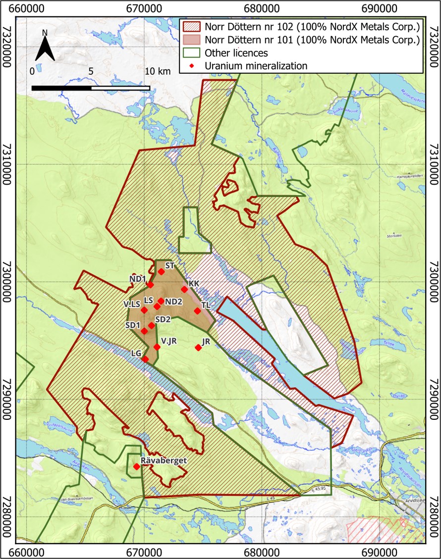
Figure 1. Map showing the exploration licence application Norr Döttern nr. 102 (hatched area), submitted by NordX, contiguous to the existing Norr Döttern nr. 101 licence in the Arvidsjaur-Arjeplog uranium province. Red diamonds represent known U occurrences (ND1 - Norr Döttern 1, ND2 - Norr Döttern 2, KK - Kikkejaure Västra, LG - Långträsk, LS - Liessetjåkke, V.LS - Västra Liessetjåkke, SR1 - Sör Döttern 1, SR2 - Sör Döttern 2, ST - Störbacken, V.JR - Västra Järntjärnbacken, JR - Järntjärnbacken).
To view an enhanced version of this graphic, please visit:
https://images.newsfilecorp.com/files/11951/318996_b4bd3bd5d4aec94a_001full.jpg
Långträsk Historical Core: Mineralization confirmed and open
ALS Global assayed 140 samples from three historical Långträsk drillholes (LAT84004, LAT84006 and LAT84011) using the multi-element ME-MS61 method (Table 1). The samples re-tested historically assayed intervals but also covered intervals never previously assayed. Sixty-seven samples returned more than 100 ppm U3O8, up to 2,034 ppm U3O8. Mineralization remains open in all directions (Figure 2). The new assays confirm the historical mineralized intervals but average
Best Intercepts:
- LAT84004: 4.4 m at 1,305 ppm U3O8 (from 77.3 m), including 1 m at 2,034 ppm U3O8 (from 79.3 m)
- LAT84006: 6.2 m at 471 ppm U3O8 (from 82.3 m), including 1.6 m at 1,027 ppm U3O8 (from 82.3 m)
- LAT84004: 3 m at 394 ppm U3O8 (from 63 m)
- LAT84011: 53 m at 131 ppm U3O8 (from 29 m)
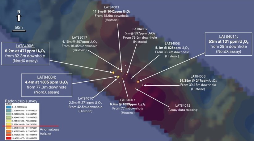
Figure 2. Map showing the collars of historical drillholes at Långträsk (all holes were drilled vertically). NordX resampling assay results are shown in white boxes and historical assay figures with no outline. Historical assay results shown have not been independently verified by a Qualified Person and should not be relied upon. The coloured contour map beneath shows the results of the radon cup survey.
To view an enhanced version of this graphic, please visit:
https://images.newsfilecorp.com/files/11951/318996_b4bd3bd5d4aec94a_002full.jpg
Flistjärn Radon Cup Survey
A total of 175 radon cups were deployed on an approximate 100 x 50 m grid (Figure 3). Anomalous values follow a NW-striking overthrust and younger NE-striking faults, indicating structurally controlled mineralization consistent with mineralization documented in outcrop during NordX's July/August 2026 rock chip program (see NordX news release dated September 22, 2026). Soil at all 175 stations was damp (148) or wet (27), which the radon service provider advises can reduce soil permeability to radon gas, suggesting values should be considered minimums relative to dry conditions.
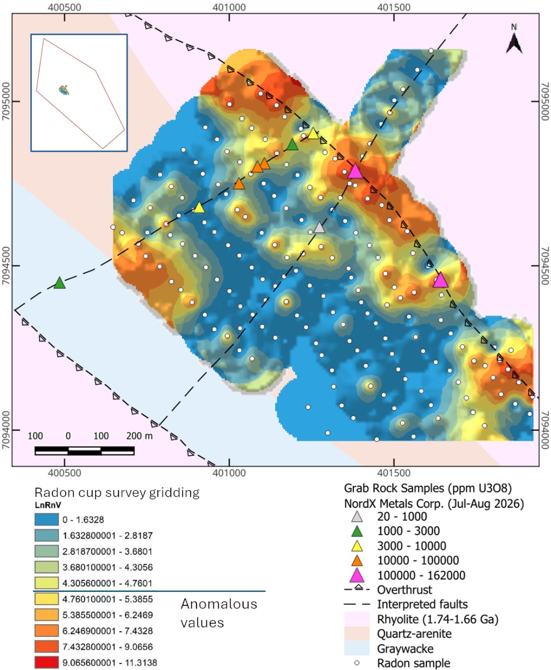
Figure 3. Map showing the results of the radon cup survey over the main target in the Flistjärn project. In upper-left corner, a detail showing the location of the surveyed area close to the centre of the exploration perimeter.
To view an enhanced version of this graphic, please visit:
https://images.newsfilecorp.com/files/11951/318996_b4bd3bd5d4aec94a_003full.jpg
Norr Döttern Radon Cup Survey
A total of 192 radon cups were deployed across four prospects (Figure 4) on lines spaced 100 m or 200 m apart, with 50 m station spacing (100 m on the SE line at Norr Döttern 2):
- Långträsk (LG, 2 lines): Historically drilled mineralization confirmed; anomalous radon suggests extensions to the N and SE. The SE anomaly may also be caused and/or amplified by a uranium-rich boulder train in the same area.
- Västra Liessetjåkke (V.LS, 3 lines): Multiple anomalous zones follow parallel NE-striking, most likely structurally controlled trends, consistent with July/August 2026 field results (see NordX news release dated September 22, 2026).
- Norr Döttern 2 (ND2, 3 lines): A significant anomaly W of the known ND2 mineralized trench - suggesting a source for the mineralized episyenite boulders found down-ice to the SE - and a second approximately 600 m SW of the trench on the same line.
- Kikkejaure Västra (KK, 2 lines): Two significant anomalies, one SW of the historically drilled area and one overlapping the historical boulder train, further suggesting the drilled area is not the boulder source. Follow-up should focus up-ice, to the NW and SW of the drilled area.
Soil at all 192 stations was damp (186) or wet (6); as at Flistjärn, values should be considered minimums relative to dry conditions.
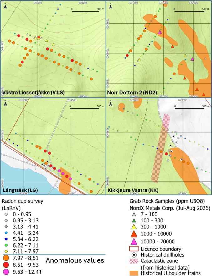
Figure 4. Map showing the results of the radon cup orientation survey over four prospects within the Norr Döttern nr. 101 exploration licence.
To view an enhanced version of this graphic, please visit:
https://images.newsfilecorp.com/files/11951/318996_nordx4.jpg
About the Norr Döttern Project
The Norr Döttern licence in Norrbotten County covers an 8 km NNE-SSW structural corridor explored by the Geological Survey of Sweden ("SGU") and Sveriges Geologiska AB ("SGAB") between 1971 and 1985, when 35 diamond holes were drilled across three historically identified prospect areas. Historical drilling intercepted up to 11.9 m grading
About the Flistjärn Project
Flistjärn is an approved exploration licence in Jämtland County, Sweden, along a 20 km uranium-anomalous corridor in the Olden tectonic window. Mineralization is considered to be granite-related and structurally controlled. SGU (1976-1985) and Mawson Resources (2005-2011) mapped the corridor, but its documented uranium occurrences and anomalies have never been drilled.
Sampling, Analytical Method and Quality Control
Remote Exploration Services (Pty) Ltd ("RES") carried out a RadonX™ survey to NordX's design. The method relies on radon (222Rn), a gaseous uranium-decay product, migrating to surface through permeable cover via porosity and/or structures (faults and fractures). Measuring gamma emission from radon's daughter products bismuth (214Bi) and lead (214Pb) excludes thoron (220Rn) derived from thorium in the bedrock. Plastic cups containing active charcoal were buried at 30-40 cm depth for 10 days, and the charcoal cartridges were measured with a portable RadonX™ unit (a gamma scintillometer in a custom lead shield to reduce background radiation) using a 2-minute counting period. RES quality control included a humidity- and radon-free cartridge-loading environment at all times, consistent charcoal weights, weighing of loaded cartridges, and regular in-sequence analysis of unexposed control cartridges to establish average background counts, which were subtracted from field measurements. Counts per second were converted to Radon Value (RnV) and transformed to its natural logarithm (LnRnV) for visualisation. Anomalous values were defined as 0.5 standard deviations above the mean: LnRnV ≥ 4.645 at Flistjärn and ≥ 7.975 at Norr Döttern. On retrieval, moisture was recorded in 116 of the 367 cups deployed (4 at Norr Döttern, 112 at Flistjärn), which may have impeded radon adsorption by the charcoal; this is separate from the station soil moisture reported above.
Historical Långträsk core was marked for cutting by NordX personnel at the SGU core archive in Malå, Sweden, and transported under chain-of-custody protocols to ALS Global in Piteå, Sweden, an internationally recognized ISO/IEC 17025-accredited laboratory. Samples were dried, crushed and pulverised to industry-standard specifications before multi-element analysis by ME-MS61.
Twelve NordX sample intervals correspond directly to intervals assayed by SGAB in 1984. The two datasets correlate strongly (Pearson correlation coefficient of 0.94), confirming the presence and relative tenor of uranium mineralization at the same depths, including the highest-grade interval in LAT84004 (79.3 m to 80.3 m), which returned 2,034 ppm U3O8 against a historical equivalent of 2,699 ppm U3O8. The new assays are, however, systematically lower, averaging
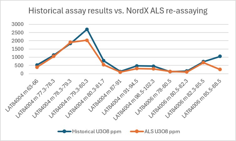
Figure 5. Graphic showing the strong correlation between the historical assay results and the recent assay results from ALS Global.
To view an enhanced version of this graphic, please visit:
https://images.newsfilecorp.com/files/11951/318996_b4bd3bd5d4aec94a_006full.jpg
Control samples made up
U3O8 values are converted from laboratory-reported elemental uranium (U) using U3O8 = U × 1.17924. All intervals are downhole lengths; true widths are not yet known, as no structural measurements of the historical core were available.
Table 1. ALS Global assay results for the Långträsk historical core.
| Drillhole ID | Sample ID | From (m) | To (m) | Interval (m) | U3O8 (ppm) |
| LAT84004 | LAT0726001 | 10.8 | 12.3 | 1.5 | 79 |
| LAT84004 | LAT0726002 | 13.3 | 14.8 | 1.5 | 144 |
| LAT84004 | LAT0726004 | 14.8 | 16 | 1.2 | 75 |
| LAT84004 | LAT0726005 | 16 | 18 | 2 | 55 |
| LAT84004 | LAT0726006 | 18 | 20 | 2 | 72 |
| LAT84004 | LAT0726007 | 20 | 22 | 2 | 64 |
| LAT84004 | LAT0726008 | 22 | 24 | 2 | 79 |
| LAT84004 | LAT0726009 | 24 | 25 | 1 | 51 |
| LAT84004 | LAT0726010 | 25 | 26 | 1 | 103 |
| LAT84004 | LAT0726012 | 32.5 | 33.5 | 1 | 95 |
| LAT84004 | LAT0726013 | 33.5 | 35.5 | 2 | 12 |
| LAT84004 | LAT0726014 | 35.5 | 36.5 | 1 | 26 |
| LAT84004 | LAT0726015 | 38 | 39 | 1 | 41 |
| LAT84004 | LAT0726016 | 39 | 41 | 2 | 12 |
| LAT84004 | LAT0726017 | 41 | 43 | 2 | 11 |
| LAT84004 | LAT0726018 | 43 | 45 | 2 | 9 |
| LAT84004 | LAT0726020 | 45 | 47 | 2 | 7 |
| LAT84004 | LAT0726021 | 59.4 | 61.5 | 2.1 | 44 |
| LAT84004 | LAT0726022 | 63 | 64 | 1 | 282 |
| LAT84004 | LAT0726023 | 64 | 65 | 1 | 526 |
| LAT84004 | LAT0726024 | 65 | 66 | 1 | 374 |
| LAT84004 | LAT0726025 | 66 | 67.5 | 1.5 | 92 |
| LAT84004 | LAT0726026 | 67.5 | 69 | 1.5 | 121 |
| LAT84004 | LAT0726028 | 69 | 70 | 1 | 174 |
| LAT84004 | LAT0726029 | 70 | 71 | 1 | 87 |
| LAT84004 | LAT0726030 | 71 | 73 | 2 | 75 |
| LAT84004 | LAT0726031 | 73 | 75 | 2 | 74 |
| LAT84004 | LAT0726032 | 75 | 76.3 | 1.3 | 134 |
| LAT84004 | LAT0726033 | 76.3 | 77.3 | 1 | 144 |
| LAT84004 | LAT0726034 | 77.3 | 78.3 | 1 | 1050 |
| LAT84004 | LAT0726036 | 78.3 | 79.3 | 1 | 1910 |
| LAT84004 | LAT0726037 | 79.3 | 80.3 | 1 | 2034 |
| LAT84004 | LAT0726038 | 80.3 | 81.7 | 1.4 | 535 |
| LAT84004 | LAT0726039 | 81.7 | 82.5 | 0.8 | 108 |
| LAT84004 | LAT0726040 | 82.5 | 84 | 1.5 | 70 |
| LAT84004 | LAT0726041 | 84 | 85.5 | 1.5 | 42 |
| LAT84004 | LAT0726042 | 85.5 | 87 | 1.5 | 29 |
| LAT84004 | LAT0726044 | 87 | 88 | 1 | 38 |
| LAT84004 | LAT0726045 | 88 | 89.5 | 1.5 | 104 |
| LAT84004 | LAT0726046 | 89.5 | 91 | 1.5 | 123 |
| LAT84004 | LAT0726047 | 91 | 92 | 1 | 337 |
| LAT84004 | LAT0726048 | 92 | 93 | 1 | 393 |
| LAT84004 | LAT0726049 | 93 | 94.5 | 1.5 | 235 |
| LAT84004 | LAT0726050 | 98.5 | 99.5 | 1 | 156 |
| LAT84004 | LAT0726052 | 99.5 | 100.5 | 1 | 250 |
| LAT84004 | LAT0726053 | 100.5 | 102.3 | 1.8 | 393 |
| LAT84004 | LAT0726054 | 102.3 | 104 | 1.7 | 16 |
| LAT84004 | LAT0726055 | 104 | 106 | 2 | 51 |
| LAT84004 | LAT0726056 | 106 | 108.1 | 2.1 | 14 |
| LAT84004 | LAT0726057 | 108.1 | 109.1 | 1 | 9 |
| LAT84004 | LAT0726058 | 114.1 | 115.1 | 1 | 76 |
| LAT84004 | LAT0726060 | 115.1 | 117.2 | 2.1 | 22 |
| LAT84004 | LAT0726061 | 117.2 | 118.7 | 1.5 | 14 |
| LAT84004 | LAT0726062 | 118.7 | 119.7 | 1 | 53 |
| LAT84004 | LAT0726063 | 119.7 | 120.7 | 1 | 37 |
| LAT84006 | LAT0726064 | 78 | 80.5 | 2.5 | 128 |
| LAT84006 | LAT0726065 | 80.5 | 82.3 | 1.8 | 98 |
| LAT84006 | LAT0726066 | 82.3 | 83.9 | 1.6 | 1,027 |
| LAT84006 | LAT0726068 | 83.9 | 85.5 | 1.6 | 316 |
| LAT84006 | LAT0726069 | 85.5 | 87 | 1.5 | 120 |
| LAT84006 | LAT0726070 | 87 | 88.5 | 1.5 | 393 |
| LAT84006 | LAT0726071 | 88.5 | 89.5 | 1 | 66 |
| LAT84006 | LAT0726072 | 89.5 | 90.5 | 1 | 42 |
| LAT84006 | LAT0726073 | 90.5 | 91.5 | 1 | 43 |
| LAT84006 | LAT0726074 | 91.5 | 92.5 | 1 | 54 |
| LAT84006 | LAT0726076 | 92.5 | 93.5 | 1 | 40 |
| LAT84006 | LAT0726077 | 93.5 | 94.5 | 1 | 53 |
| LAT84006 | LAT0726078 | 94.5 | 95.5 | 1 | 18 |
| LAT84006 | LAT0726079 | 95.5 | 96.5 | 1 | 59 |
| LAT84006 | LAT0726080 | 96.5 | 97.5 | 1 | 39 |
| LAT84006 | LAT0726081 | 97.5 | 99 | 1.5 | 40 |
| LAT84006 | LAT0726082 | 99 | 100.5 | 1.5 | 36 |
| LAT84006 | LAT0726084 | 100.5 | 102 | 1.5 | 25 |
| LAT84011 | LAT0726085 | 9.1 | 10.2 | 1.1 | 162 |
| LAT84011 | LAT0726086 | 10.2 | 11.2 | 1 | 198 |
| LAT84011 | LAT0726087 | 11.2 | 12.2 | 1 | 250 |
| LAT84011 | LAT0726088 | 12.2 | 13.2 | 1 | 200 |
| LAT84011 | LAT0726089 | 13.2 | 14.2 | 1 | 169 |
| LAT84011 | LAT0726090 | 19.7 | 20.5 | 0.8 | 45 |
| LAT84011 | LAT0726092 | 20.5 | 21.5 | 1 | 34 |
| LAT84011 | LAT0726093 | 21.5 | 23 | 1.5 | 38 |
| LAT84011 | LAT0726094 | 23 | 24.5 | 1.5 | 77 |
| LAT84011 | LAT0726095 | 24.5 | 26 | 1.5 | 67 |
| LAT84011 | LAT0726096 | 26 | 27.5 | 1.5 | 20 |
| LAT84011 | LAT0726097 | 27.5 | 29 | 1.5 | 28 |
| LAT84011 | LAT0726098 | 29 | 30 | 1 | 174 |
| LAT84011 | LAT0726100 | 30 | 31 | 1 | 36 |
| LAT84011 | LAT0726101 | 31 | 32 | 1 | 157 |
| LAT84011 | LAT0726102 | 32 | 33 | 1 | 117 |
| LAT84011 | LAT0726103 | 33 | 34 | 1 | 171 |
| LAT84011 | LAT0726104 | 34 | 35 | 1 | 136 |
| LAT84011 | LAT0726105 | 35 | 36 | 1 | 98 |
| LAT84011 | LAT0726106 | 36 | 37 | 1 | 117 |
| LAT84011 | LAT0726108 | 37 | 38 | 1 | 129 |
| LAT84011 | LAT0726109 | 38 | 39 | 1 | 45 |
| LAT84011 | LAT0726110 | 39 | 40 | 1 | 55 |
| LAT84011 | LAT0726111 | 40 | 41 | 1 | 60 |
| LAT84011 | LAT0726112 | 41 | 42 | 1 | 57 |
| LAT84011 | LAT0726113 | 42 | 44 | 2 | 25 |
| LAT84011 | LAT0726114 | 44 | 45 | 1 | 52 |
| LAT84011 | LAT0726116 | 45 | 46 | 1 | 159 |
| LAT84011 | LAT0726117 | 46 | 47 | 1 | 218 |
| LAT84011 | LAT0726118 | 47 | 48 | 1 | 232 |
| LAT84011 | LAT0726119 | 48 | 49 | 1 | 172 |
| LAT84011 | LAT0726120 | 49 | 50 | 1 | 63 |
| LAT84011 | LAT0726121 | 50 | 51 | 1 | 129 |
| LAT84011 | LAT0726122 | 51 | 52 | 1 | 150 |
| LAT84011 | LAT0726124 | 52 | 52.85 | 0.85 | 116 |
| LAT84011 | LAT0726125 | 52.85 | 53.9 | 1.05 | 42 |
| LAT84011 | LAT0726126 | 53.9 | 55 | 1.1 | 118 |
| LAT84011 | LAT0726127 | 55 | 56 | 1 | 140 |
| LAT84011 | LAT0726128 | 56 | 57 | 1 | 206 |
| LAT84011 | LAT0726129 | 57 | 58 | 1 | 179 |
| LAT84011 | LAT0726130 | 58 | 59 | 1 | 246 |
| LAT84011 | LAT0726132 | 59 | 60 | 1 | 204 |
| LAT84011 | LAT0726133 | 60 | 61 | 1 | 56 |
| LAT84011 | LAT0726134 | 61 | 62 | 1 | 106 |
| LAT84011 | LAT0726135 | 62 | 63 | 1 | 137 |
| LAT84011 | LAT0726136 | 63 | 64 | 1 | 61 |
| LAT84011 | LAT0726137 | 64 | 65 | 1 | 55 |
| LAT84011 | LAT0726138 | 65 | 66 | 1 | 74 |
| LAT84011 | LAT0726140 | 66 | 67 | 1 | 230 |
| LAT84011 | LAT0726141 | 67 | 68 | 1 | 221 |
| LAT84011 | LAT0726142 | 68 | 69 | 1 | 301 |
| LAT84011 | LAT0726143 | 69 | 70 | 1 | 212 |
| LAT84011 | LAT0726144 | 70 | 71 | 1 | 54 |
| LAT84011 | LAT0726145 | 71 | 72 | 1 | 67 |
| LAT84011 | LAT0726146 | 72 | 73 | 1 | 85 |
| LAT84011 | LAT0726148 | 73 | 74 | 1 | 146 |
| LAT84011 | LAT0726149 | 74 | 75 | 1 | 151 |
| LAT84011 | LAT0726150 | 75 | 76 | 1 | 177 |
| LAT84011 | LAT0726151 | 76 | 77 | 1 | 162 |
| LAT84011 | LAT0726152 | 77 | 78 | 1 | 135 |
| LAT84011 | LAT0726153 | 78 | 79 | 1 | 173 |
| LAT84011 | LAT0726154 | 79 | 80 | 1 | 129 |
| LAT84011 | LAT0726156 | 80 | 81 | 1 | 183 |
| LAT84011 | LAT0726157 | 81 | 82 | 1 | 180 |
| LAT84011 | LAT0726158 | 84 | 85 | 1 | 46 |
| LAT84011 | LAT0726159 | 85 | 86 | 1 | 86 |
| LAT84011 | LAT0726160 | 86 | 87 | 1 | 59 |
Qualified Person
The Company's Qualified Person ("QP") is Avrom E. Howard, MSc, PGeo (Ontario), Principal Geologist at Nebu Consulting, LLC, an independent US-based mineral exploration consulting firm. Mr. Howard is independent of NordX and is a Qualified Person as defined by National Instrument 43-101. The Company's technical team reviewed for Mr. Howard its sampling procedure, QA/QC protocol and results for the historical Långträsk core, and the RadonX™ survey data and methodology provided by RES and presented him with the ALS Global analytical data for comparison with the results reported in this news release. Mr. Howard approves the technical contents of this news release; however, he has not verified the historical drilling and assay results referenced herein, which are historical in nature and should not be relied upon.
About NordX Metals Corp.
NordX is an exploration and development company advancing uranium, lithium, and rare earth projects in politically stable jurisdictions with the infrastructure to support rapid, cost-effective exploration, development, and production.
The Company's consolidated financial statements and related management's discussion and analysis are available on the Company's website at https://nordxmetals.com or under its profile on SEDAR+ at www.sedarplus.ca.
On Behalf of NordX Metals Corp.
"Andrew Bowering"
Interim Chief Executive Officer
Telephone: +1-604-428-6128
Email: ir@nordxmetals.com
The Canadian Securities Exchange has not approved nor disapproved the contents of this news release and does not accept responsibility for the adequacy or accuracy of this release.
Forward-Looking Statements
This news release includes "forward-looking statements" and "forward-looking information" within the meaning of Canadian securities legislation. All statements included in this news release, other than statements of historical fact, are forward-looking statements, including, without limitation, statements regarding the grant, timing, scope and terms of the Norr Döttern 102 exploration licence application; the Company's interpretation of the radon cup orientation survey results at Flistjärn and Norr Döttern, including the inference of structural control of mineralization and of bedrock sources for mineralized boulder trains; the district-scale potential of Norr Döttern; the Company's interpretation of historical drilling and geochemical data at Norr Döttern and Flistjärn; the Company's expectations regarding the significance of the historical core assay results disclosed in this news release and the potential for the Långträsk mineralization to remain open in all directions; and the timing, scope and results of the Company's current and future exploration and drilling programs at Norr Döttern and Flistjärn, including its plans to advance the radon and surface anomalies disclosed in this news release to drill-ready targets. Forward-looking statements are often identified by the use of words such as "anticipate", "believe", "plan", "estimate", "expect", "potential", "target", "budget" and "intend" and statements that an event or result "may", "will", "should", "could" or "might" occur or be achieved and other similar expressions, including the negatives thereof.
Forward-looking statements are based on the reasonable assumptions, estimates, analysis and opinions of management made in light of its experience, current conditions and expected developments, as well as other factors management believes to be appropriate in the circumstances. Such statements are subject to known and unknown risks, uncertainties and other factors that may cause actual results or events to differ materially from those expressed or implied by such forward-looking statements. These risks and uncertainties include, but are not limited to, the risk that the Norr Döttern 102 exploration licence application is not granted, is granted on different terms, or is subsequently challenged; the risk that radon anomalies do not reflect underlying uranium mineralization, and that soil moisture, overburden thickness and permeability may materially affect radon measurements; the risk that historical drill and assay results, which have not been independently verified by a Qualified Person, are inaccurate or cannot be reproduced; the risk that boulder (float) samples may not be sourced from or proximal to a bedrock source and that drilling may not locate in-situ mineralization; permit title, transfer, validity and renewal risk; changes in Swedish government policy or legislation relating to uranium exploration and mining; survey and drilling timing and results; risks associated with mineral exploration and development; metal and mineral prices; availability of capital and financing; changes in market conditions; regulatory approvals; environmental and permitting risks; operational and technical difficulties; title matters; competition; fluctuations in interest and exchange rates; and general economic, market and business conditions.
Although the Company believes the assumptions and expectations reflected in the forward-looking statements are reasonable, there can be no assurance that such statements will prove to be accurate. Actual results and future events could differ materially from those anticipated in such statements. Accordingly, readers should not place undue reliance on forward-looking statements. The forward-looking information contained herein is made as of the date of this news release, and the Company does not undertake to update any forward-looking information except in accordance with applicable securities laws.

To view the source version of this press release, please visit https://www.newsfilecorp.com/release/318996
FAQ
AI-generated questions and answers. How Rhea-AI works. Not financial advice.
How much ground is NordX Metals seeking to add at Norr Döttern?
NordX Metals has applied for 34,459 hectares through the Norr Döttern 102 exploration licence application. The proposed ground is contiguous with Norr Döttern 101 to the north and south, covering similar rock types along the same north-northeast structural trend.
What were NordX Metals’ best Långträsk core resampling results?
Hole LAT84004 returned 4.4 m at 1,305 ppm U3O8 from 77.3 m, including 1 m at 2,034 ppm U3O8. LAT84006 returned 6.2 m at 471 ppm U3O8 from 82.3 m, while LAT84011 returned 53 m at 131 ppm U3O8 from 29 m.
Why were NordX Metals’ new Långträsk assays lower than historical results?
NordX attributes the differences to different analytical methods, sampling the core remaining after the original sampling, and uneven mineralization concentrated along fractures. Twelve directly comparable intervals showed a correlation coefficient of 0.94, but new assays averaged 24% lower. The historical assays have not been independently verified by a Qualified Person and should not be relied upon.