Powermax Announces Plans for Phase 1 Exploration Program for the Pinard Project
Rhea-AI Summary
Powermax (OTCQB: PWMXF) announced a Phase 1 exploration program for the recently optioned Pinard REE Project in northern Ontario on December 5, 2025. The 5,178 ha property lies ~70 km NNE of Kapuskasing and comprises 255 contiguous claims with all-weather road access.
The program will integrate historical datasets with new fieldwork and includes: desktop GIS compilation, prospecting and mapping, rock/soil/stream geochemical sampling, handheld radiometric surveys, and a helicopter-borne magnetic and gamma-ray survey to refine and prioritize targets for trenching and potential drilling.
AI-generated analysis. How Rhea-AI works. Not financial advice.
Positive
- None.
Negative
- None.
News Market Reaction – PWMXF
On the day this news was published, PWMXF gained 2.94%, reflecting a moderate positive market reaction.
Data tracked by StockTitan Argus on the day of publication.
Key Figures
Historical Context
| Date | Event | Sentiment | 24h Move | Catalyst |
|---|---|---|---|---|
| Dec 05 | Phase 1 plan | Positive | +2.9% | Announced systematic Phase 1 exploration at newly optioned Pinard REE project. |
| Nov 25 | Fieldwork completion | Positive | +1.1% | Completed Phase 2 field program at Cameron REE Project with samples submitted. |
| Nov 18 | Geophysical survey | Positive | -1.7% | Completed high-resolution airborne MAG/RAD survey at Atikokan REE Property. |
| Nov 13 | Option payments | Positive | +4.8% | Made initial option payments and shares to acquire Pinard REE project. |
| Nov 10 | Target definition | Positive | -4.3% | Identified high-priority REE targets at Atikokan based on integrated study. |
24h Move is the share-price change in the day after each event; other market factors may also have contributed.
News on new exploration phases and project milestones has often seen modest positive alignment, though technical updates at other properties have sometimes led to negative reactions.
Over the past months, Powermax issued several project-focused updates. On Nov 10 and Nov 18, technical work at the Atikokan REE Property, including targeting and airborne surveys, saw mixed price reactions. On Nov 13, initial milestone payments to option the Pinard REE project were completed. Subsequent Cameron REE Phase 2 exploration and completion updates in late November supported incremental gains. Today’s Pinard Phase 1 plan extends this sequence by outlining systematic early-stage work on the newly optioned property.
Key Terms
peralkalic medical
pegmatite technical
geochemical sampling technical
radiometric surveys technical
scintillometer technical
gamma-ray spectrometric survey technical
national instrument 43-101 regulatory
AI-generated analysis. How Rhea-AI works. Not financial advice.
Toronto, Ontario--(Newsfile Corp. - December 5, 2025) - Powermax Minerals Inc. (CSE: PMAX) (OTCQB: PWMXF) (FWB: T23) ("Powermax" or the "Company") is pleased to announce its plans for Phase 1 exploration program for its recently optioned Pinard Project (the "Project"). The Phase 1 program has been designed to integrate historical data with new fieldwork to advance target generation and prioritize areas for follow-up exploration.
The Pinard REE Property is located in northern Ontario, Canada, roughly 70 km north-northeast of the town of Kapuskasing, and is defined by 255 contiguous mining claims spanning a total of 5178 ha. The mining claims and patents can be easily accessed via all-weather access road.
The Pinard Intrusive Complex is an alkalic to peralkalic igneous body, comprising syenitic to granitic phases consistent with other alkaline plutonic systems in the southern Archean Superior Province. Alkaline complexes of this type commonly form in extensional tectonic environments, including rift zones or deep-seated fault structures. Although the Kapuskasing Structural Zone is dominated by exhumed high-grade Archean basement, several alkaline intrusions including Pinard occur within its broader influence. Regionally, the Pinard Complex shares tectonomagmatic similarities with the nearby Clay-Howells Alkaline Complex, located approximately 20 km to the southwest, which hosts a known niobium-REE mineralized system.
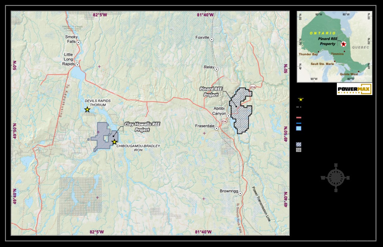
Figure 1: Pinard REE Property Location Map
To view an enhanced version of this graphic, please visit:
https://images.newsfilecorp.com/files/11633/277023_0b949132a4224b23_001full.jpg
The Proposed Phase 1 program at the Property will consist of the following components:
Desktop Data Compilation & GIS Modeling
Powermax plans to complete a comprehensive compilation and analysis of all available historical geological, geophysical, and geochemical datasets. These datasets would be integrated into a modern GIS-based exploration platform to refine exploration targets using advanced spatial analysis and radiometric interpretation techniques.
Field Prospecting & Geological Mapping
Systematic field prospecting and detailed geological mapping will be conducted across priority target areas to identify and characterize pegmatite zones, mineralized structures, lithological contacts, and alteration patterns.
Geochemical Sampling
The Phase 1 program will include multi-media geochemical sampling, including:
- Rock sampling of outcrops and mineralized occurrences
- Soil sampling across defined target grids
- Stream sediment sampling within key drainage catchments
Sampling results will be used to vector toward areas of potential mineralization and refine exploration targets.
Radiometric Surveys
Handheld scintillometer surveys will be conducted across target areas to detect radiometric anomalies and associated pathfinder elements in support of target delineation.
Airborne Geophysical Survey
Powermax is planning a high-resolution helicopter-borne magnetic and gamma-ray spectrometric survey over key portions of the Project area. The airborne survey is expected to assist in identifying structural trends, lithological boundaries, and radiometric anomalies associated with prospective mineralization.
"The Phase 1 program at Pinard is designed to rapidly advance our technical understanding of the Project by combining historical datasets with modern exploration techniques," said Paul Gorman, CEO of Powermax. "This systematic approach will allow us to efficiently identify and prioritize high-quality targets for follow-up work."
The Phase 1 exploration program is intended to integrate historical and newly acquired field data to generate and rank priority targets for subsequent advanced exploration programs, including trenching and potential drilling.
Qualified Person
The technical information contained in this news release has been reviewed and approved by Afzaal Pirzada, P.Geo., who is a director of the Company and a Qualified Person under National Instrument 43-101 - Standards of Disclosure for Mineral Projects.
On Behalf of the Board of Directors
Paul Gorman, CEO & Director
Email: info@powermaxminerals.com
Website: www.powermaxminerals.com
Tel: (416) 768-6101
About Powermax Minerals Inc.
Powermax Minerals Inc. is a Canadian mineral exploration company focused on advancing rare earth element projects. The Company holds an option to acquire the Cameron REE Property, comprising three mineral claims totaling approximately 2,984 hectares in British Columbia. Powermax also optioned to acquire the Atikokan REE Property, consisting of 455 unpatented mining claims in NW Ontario. Powermax also optioned to acquire the 5178 hectare Pinard REE in Northern Ontario. Powermax also owns a
Forward-Looking Statements
This news release may contain 'forward-looking statements' within the meaning of applicable Canadian securities legislation. Forward-looking statements are based on current expectations and assumptions of management and are subject to known and unknown risks, uncertainties, and other factors that may cause actual results, performance, or achievements to differ materially from those expressed or implied. Such statements include, but are not limited to, statements regarding potential mineralization, exploration plans, timing of activities, and future exploration results. Readers are cautioned not to place undue reliance on these forward-looking statements. Powermax Minerals Inc. disclaims any intention or obligation to update or revise any forward-looking statements whether as a result of new information, future events, or otherwise, except as required by applicable securities laws.
Neither the Canadian Securities Exchange nor its Market Regulator (as defined in CSE policies) accepts responsibility for the adequacy or accuracy of this news release.
![]()
To view the source version of this press release, please visit https://www.newsfilecorp.com/release/277023